Bridge Statistics for Lake Heritage, Pennsylvania (PA)
Condition, Traffic, Stress, Structural Evaluation, Project Costs
- National Bridge Inventory (NBI) Statistics
- 13Number of bridges
- 49ft / 15.0mTotal length
- $110,000Total costs
- 90,785Total average daily traffic
- 14,105Total average daily truck traffic
- National Bridge Inventory (NBI) Registered Bridges for Lake Heritage
- No street view available for this location
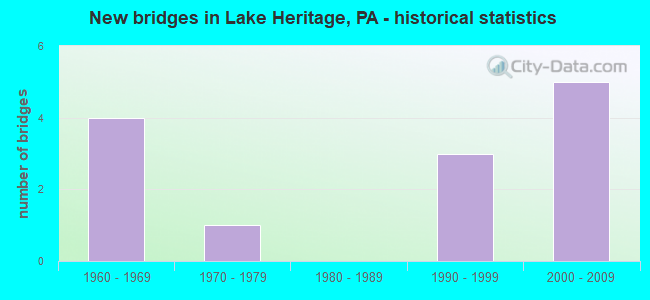
- New bridges - historical statistics
- 41960-1969
- 11970-1979
- 31990-1999
- 52000-2009


- Bridge Condition - Deck
- 66.7%Good
- 33.3%Fair

- Bridge Condition - Superstructure
- 16.7%Very good
- 83.3%Good

- Bridge Condition - Channel
- 40.0%Good
- 60.0%Fair
Find on map >> Show street view
Structure Number: 1, Location: S OF GETTYSBURG (Lat: 39.786936, Lng: -77.217014), Route carried "on" structure: State highway , Year Built: 1963, Status: Open, Structure Length: 1.40m (4.59ft), Average Daily Traffic: 151 (year 2022), Truck Traffic: 7%, Average Future Daily Traffic: 188 (year 2032), Design Load: HS 20, Features Intersected: US 15 SB; SR 0015, Facility Carried by Structure: T-417; SACH'S RD
Minimum Vertical Clearance: 30+ m (98+ ft), Kilometerpoint: 0.000, Lanes on structure: 2, Lanes under structure: 2, Owner: State Highway Agency, Approaching Roadway Width: 5.2m (17.1ft), Material/Design: Prestressed concrete, Design/Construction: Box Beam or Girders - Single/Spread, Number Of Spans In Main Unit: 1, Length of Maximum Span: 12.8m (42.0ft), Curb or Sidewalk Widths: Left: 0.5m (1.6ft), Right: 0.5m (1.6ft), Curb-To-Curb Width: 9.1m (29.9ft), Out-to-Out Width: 11.0m (36.1ft)
Condition: Deck: Fair, Superstructure: Good, Substructure: Good, Operating Rating: 72.6 metric tons, Method Used To Determine Operating Rating: Load Factor (LF), Inventory Rating: 29.9 metric tons, Method Used To Determine Inventory Rating: Load Factor (LF), Structural Evaluation: Better than present minimum criteria, Deck Geometry: Equal to present minimum criteria, Underclear: Meets minimum limits, Approach Roadway Alignment: Equal to present desirable criteria, Designated Inspection Frequency: Every 24 months, Inspection Date: January 2021, Deck Structure Type: Concrete Cast-file-Place, Wearing Surface/Protective System: Wearing Surface: Bituminous
Find on map >> Show street view
Structure Number: 13, Location: S OF GETTYSBURG (Lat: 39.792489, Lng: -77.207911), Route carried "on" structure: US 15, Year Built: 1963, Status: Open, Structure Length: 4.69m (15.39ft), Average Daily Traffic: 9,627 (year 2022), Truck Traffic: 22%, Average Future Daily Traffic: 12,732 (year 2032), Design Load: HS 20, Features Intersected: ROCK CREEK
Minimum Vertical Clearance: 30+ m (98+ ft), Kilometerpoint: 12.114, Lanes on structure: 2, Base Highway Network: Yes, Owner: State Highway Agency, Approaching Roadway Width: 12.2m (40.0ft), Skew: 13 degrees, Material/Design: Prestressed concrete, Design/Construction: Stringer/Multi-beam, Number Of Spans In Main Unit: 2, Length of Maximum Span: 22.9m (75.1ft), Curb or Sidewalk Widths: Left: 0.2m (0.7ft), Right: 0.2m (0.7ft), Curb-To-Curb Width: 12.2m (40.0ft), Out-to-Out Width: 13.9m (45.6ft)
Condition: Deck: Fair, Superstructure: Good, Substructure: Good, Channel: Good, Operating Rating: 65.3 metric tons, Method Used To Determine Operating Rating: Load Factor (LF), Inventory Rating: 26.3 metric tons, Method Used To Determine Inventory Rating: Load Factor (LF), Structural Evaluation: Equal to present minimum criteria, Deck Geometry: Better than present minimum criteria, Waterway Adequacy: Superior to present desirable criteria, Approach Roadway Alignment: Equal to present desirable criteria, Designated Inspection Frequency: Every 24 months, Inspection Date: January 2021, Deck Structure Type: Concrete Cast-file-Place, Wearing Surface/Protective System: Wearing Surface: Latex Concrete
Find on map >> Show street view
Structure Number: 456, Location: 3.5 SE GBURG/LITTLES RUN (Lat: 39.781900, Lng: -77.195300), Route carried "on" structure: City street , Year Built: 1978, Status: Open, Structure Length: 1.13m (3.71ft), Average Daily Traffic: 300 (year 2009), Truck Traffic: 1%, Average Future Daily Traffic: 420 (year 2030), Design Load: HS 20, Features Intersected: LITTLES RUN, Facility Carried by Structure: WHITE CHURCH ROAD
Minimum Vertical Clearance: 30+ m (98+ ft), Kilometerpoint: 0.000, Lanes on structure: 2, Owner: County Highway Agency, Approaching Roadway Width: 6.1m (20.0ft), Skew: 1 degrees, Material/Design: Prestressed concrete, Design/Construction: Box Beam or Girders - Multiple, Number Of Spans In Main Unit: 1, Length of Maximum Span: 11.0m (36.1ft), Curb or Sidewalk Widths: Left: 0.2m (0.7ft), Right: 0.2m (0.7ft), Curb-To-Curb Width: 9.1m (29.9ft), Out-to-Out Width: 10.2m (33.5ft)
Condition: Deck: Good, Superstructure: Good, Substructure: Good, Channel: Fair, Operating Rating: 59.0 metric tons, Method Used To Determine Operating Rating: Load and Resistance Factor (LRFR), Inventory Rating: 29.9 metric tons, Method Used To Determine Inventory Rating: Load and Resistance Factor (LRFR), Structural Evaluation: Better than present minimum criteria, Deck Geometry: Equal to present minimum criteria, Waterway Adequacy: Somewhat better than minimum adequacy, Approach Roadway Alignment: Equal to present desirable criteria, Length Of Structure Improvement: 1.70m (5.58ft), Designated Inspection Frequency: Every 24 months, Inspection Date: May 2021, Deck Structure Type: Other, Wearing Surface/Protective System: Wearing Surface: Bituminous
Find on map >> Show street view
Structure Number: 40971, Location: 2.5 MI S.E. OF GETTYSBURG (Lat: 39.799297, Lng: -77.200817), Route carried "on" structure: State highway 97, Year Built: 2000, Status: Open, Structure Length: 4.36m (14.30ft), Average Daily Traffic: 8,124 (year 2022), Truck Traffic: 6%, Average Future Daily Traffic: 12,156 (year 2032), Design Load: HS 25 or greater, Features Intersected: US 15; SR 0015
Minimum Vertical Clearance: 30+ m (98+ ft), Kilometerpoint: 15.023, Lanes on structure: 5, Lanes under structure: 4, Base Highway Network: Yes, Owner: State Highway Agency, Approaching Roadway Width: 18.9m (62.0ft), Material/Design: Prestressed concrete, Design/Construction: Box Beam or Girders - Single/Spread, Number Of Spans In Main Unit: 2, Length of Maximum Span: 21.3m (69.9ft), Curb or Sidewalk Widths: Left: 1.5m (4.9ft), Right: 0.2m (0.7ft), Curb-To-Curb Width: 18.9m (62.0ft), Out-to-Out Width: 21.6m (70.9ft)
Condition: Deck: Good, Superstructure: Good, Substructure: Good, Operating Rating: 89.8 metric tons, Method Used To Determine Operating Rating: Load Factor (LF), Inventory Rating: 39.0 metric tons, Method Used To Determine Inventory Rating: Load Factor (LF), Structural Evaluation: Better than present minimum criteria, Deck Geometry: Meets minimum limits, Underclear: High priority of corrective action, Approach Roadway Alignment: Equal to present desirable criteria, Length Of Structure Improvement: 5.30m (17.39ft), Designated Inspection Frequency: Every 24 months, Inspection Date: March 2021, Deck Structure Type: Concrete Cast-file-Place, Wearing Surface/Protective System: Wearing Surface: Monolithic Concrete, Deck Protection: Epoxy Coated Reinforcing
Find on map >> Show street view
Structure Number: 42356, Location: S.E.OF GETTYSBURG (Lat: 39.795986, Lng: -77.197133), Route carried "on" structure: State highway 97, Year Built: 2003, Status: Open, Structure Length: 1.49m (4.89ft), Average Daily Traffic: 8,124 (year 2022), Truck Traffic: 6%, Average Future Daily Traffic: 12,156 (year 2032), Design Load: HL 93, Features Intersected: WHITE RUN
Minimum Vertical Clearance: 30+ m (98+ ft), Kilometerpoint: 13.916, Lanes on structure: 2, Base Highway Network: Yes, Owner: State Highway Agency, Approaching Roadway Width: 10.7m (35.1ft), Material/Design: Prestressed concrete, Design/Construction: Box Beam or Girders - Single/Spread, Number Of Spans In Main Unit: 1, Length of Maximum Span: 14.0m (45.9ft), Curb or Sidewalk Widths: Left: 2.0m (6.6ft), Right: 0.2m (0.7ft), Curb-To-Curb Width: 12.2m (40.0ft), Out-to-Out Width: 14.9m (48.9ft)
Condition: Deck: Good, Superstructure: Good, Substructure: Good, Channel: Good, Operating Rating: 55.3 metric tons, Method Used To Determine Operating Rating: Load and Resistance Factor (LRFR), Inventory Rating: 42.6 metric tons, Method Used To Determine Inventory Rating: Load and Resistance Factor (LRFR), Structural Evaluation: Better than present minimum criteria, Deck Geometry: Somewhat better than minimum adequacy, Waterway Adequacy: Equal to present minimum criteria, Approach Roadway Alignment: Equal to present desirable criteria, Length Of Structure Improvement: 2.20m (7.22ft), Designated Inspection Frequency: Every 24 months, Inspection Date: March 2021, Bridge Improvement Cost: $8,000, Roadway Improvement Cost: $24,000, Total Project Cost: $110,000, Deck Structure Type: Concrete Cast-file-Place, Wearing Surface/Protective System: Wearing Surface: Monolithic Concrete, Deck Protection: Epoxy Coated Reinforcing
Find on map >> Show street view
Structure Number: 44145, Location: South East of Gettysburg (Lat: 39.778158, Lng: -77.165142), Route carried "on" structure: State highway 97, Year Built: 2007, Status: Open, Structure Length: 1.28m (4.20ft), Average Daily Traffic: 6,906 (year 2020), Truck Traffic: 13%, Average Future Daily Traffic: 11,270 (year 2032), Design Load: HL 93, Features Intersected: LITTLE RUN
Minimum Vertical Clearance: 30+ m (98+ ft), Kilometerpoint: 11.051, Lanes on structure: 2, Base Highway Network: Yes, Owner: State Highway Agency, Approaching Roadway Width: 12.6m (41.3ft), Skew: 1 degrees, Material/Design: Prestressed concrete, Design/Construction: Box Beam or Girders - Single/Spread, Number Of Spans In Main Unit: 1, Length of Maximum Span: 11.9m (39.0ft), Curb or Sidewalk Widths: Left: 0.9m (3.0ft), Right: 0.0m, Curb-To-Curb Width: 12.2m (40.0ft), Out-to-Out Width: 13.2m (43.3ft)
Condition: Deck: Good, Superstructure: Very good, Substructure: Good, Channel: Fair, Operating Rating: 61.7 metric tons, Method Used To Determine Operating Rating: Load and Resistance Factor (LRFR), Inventory Rating: 47.2 metric tons, Method Used To Determine Inventory Rating: Load and Resistance Factor (LRFR), Structural Evaluation: Better than present minimum criteria, Deck Geometry: Somewhat better than minimum adequacy, Waterway Adequacy: Equal to present minimum criteria, Approach Roadway Alignment: Equal to present desirable criteria, Designated Inspection Frequency: Every 48 months, Inspection Date: June 2019, Deck Structure Type: Concrete Cast-file-Place, Wearing Surface/Protective System: Wearing Surface: Monolithic Concrete, Deck Protection: Epoxy Coated Reinforcing
Find on map >> Show street view
Structure Number: 57539, Location: WILLOW ROAD BRIDGE (Lat: 39.804350, Lng: -77.172964), Route carried "on" structure: City street , Year Built: 1993, Status: Open, Structure Length: 0.67m (2.20ft), Average Daily Traffic: 100 (year 2020), Truck Traffic: 1%, Average Future Daily Traffic: 125 (year 2040), Features Intersected: WHITE RUN, Facility Carried by Structure: WILLOW ROAD
Minimum Vertical Clearance: 30+ m (98+ ft), Kilometerpoint: 0.000, Lanes on structure: 2, Owner: Town or Township Highway Agency, Approaching Roadway Width: 6.1m (20.0ft), Material/Design: Concrete, Design/Construction: Culvert, Number Of Spans In Main Unit: 1, Length of Maximum Span: 6.1m (20.0ft), Curb-To-Curb Width: 7.0m (23.0ft), Out-to-Out Width: 10.1m (33.1ft)
Condition: Channel: Fair, Culverts: Good, Operating Rating: 81.6 metric tons, Method Used To Determine Operating Rating: Field evaluation and documented engineering judgment, Inventory Rating: 49.0 metric tons, Method Used To Determine Inventory Rating: Field evaluation and documented engineering judgment, Structural Evaluation: Better than present minimum criteria, Deck Geometry: Somewhat better than minimum adequacy, Waterway Adequacy: Equal to present minimum criteria, Approach Roadway Alignment: Equal to present desirable criteria, Designated Inspection Frequency: Every 24 months, Inspection Date: August 2020
Find on map >> Show street view
Structure Number: 8, Location: SOUTH OF GETTYSBURG (Lat: 39.786631, Lng: -77.216575), Route carried "under" structure: US 15, Year Built: 1990, Structure Length: 0. m, Average Daily Traffic: 10,335 (year 2022), Truck Traffic: 22%, Features Intersected: US 15 NB; SR 0015, Facility Carried by Structure: T-417; SACH'S RD
Minimum Vertical Clearance: 4.72m (15.49ft), Kilometerpoint: 10.709, Lanes on structure: 2, Lanes under structure: 2, Material/Design: Prestressed concrete, Design/Construction: Stringer/Multi-beam, Length of Maximum Span: 26.5m (86.9ft)
Find on map >> Show street view
Structure Number: 1, Location: S OF GETTYSBURG (Lat: 39.786936, Lng: -77.217014), Route carried "under" structure: US 15, Year Built: 1963, Structure Length: 0. m, Average Daily Traffic: 9,627 (year 2022), Truck Traffic: 22%, Features Intersected: US 15 SB; SR 0015, Facility Carried by Structure: T-417; SACH'S RD
Minimum Vertical Clearance: 4.65m (15.26ft), Kilometerpoint: 10.741, Lanes on structure: 2, Lanes under structure: 2, Material/Design: Prestressed concrete, Design/Construction: Box Beam or Girders - Single/Spread, Length of Maximum Span: 12.8m (42.0ft)
Find on map >> Show street view
Structure Number: 14, Location: US15 & PA 116 INTERCHANGE (Lat: 39.824617, Lng: -77.198053), Route carried "under" structure: State highway 116, Year Built: 1990, Structure Length: 0. m, Average Daily Traffic: 7,582 (year 2020), Truck Traffic: 9%, Features Intersected: PA 116; SR 0116, Facility Carried by Structure: US 15 NB; SR 0015
Minimum Vertical Clearance: 4.52m (14.83ft), Kilometerpoint: 22.248, Lanes on structure: 2, Lanes under structure: 2, Material/Design: Prestressed concrete, Design/Construction: Box Beam or Girders - Single/Spread, Length of Maximum Span: 12.8m (42.0ft)
Find on map >> Show street view
Structure Number: 15, Location: 2 MI. E. OF GETTYSBURG (Lat: 39.824722, Lng: -77.198400), Route carried "under" structure: State highway 116, Year Built: 1963, Structure Length: 0. m, Average Daily Traffic: 7,582 (year 2020), Truck Traffic: 9%, Features Intersected: PA 116; SR 0116, Facility Carried by Structure: US 15 SB; SR 0015
Minimum Vertical Clearance: 4.90m (16.08ft), Kilometerpoint: 22.248, Lanes on structure: 2, Lanes under structure: 2, Material/Design: Prestressed concrete, Design/Construction: Box Beam or Girders - Single/Spread, Length of Maximum Span: 12.8m (42.0ft)
Find on map >> Show street view
Structure Number: 40971, Location: 2.5 MI S.E. OF GETTYSBURG (Lat: 39.799297, Lng: -77.200817), Route carried "under" structure: US 15, Year Built: 2000, Structure Length: 0. m, Average Daily Traffic: 11,478 (year 2022), Truck Traffic: 19%, Features Intersected: US 15; SR 0015, Facility Carried by Structure: PA 97; SR 0097
Minimum Vertical Clearance: 4.55m (14.93ft), Kilometerpoint: 13.113, Lanes on structure: 5, Lanes under structure: 2, Material/Design: Prestressed concrete, Design/Construction: Box Beam or Girders - Single/Spread, Length of Maximum Span: 21.3m (69.9ft)
Find on map >> Show street view
Structure Number: 40971, Location: 2.5 MI S.E. OF GETTYSBURG (Lat: 39.799297, Lng: -77.200817), Route carried "under" structure: US 15, Year Built: 2000, Structure Length: 0. m, Average Daily Traffic: 10,849 (year 2022), Truck Traffic: 20%, Features Intersected: US 15; SR 0015, Facility Carried by Structure: PA 97; SR 0097
Minimum Vertical Clearance: 4.62m (15.16ft), Kilometerpoint: 13.081, Lanes on structure: 5, Lanes under structure: 2, Material/Design: Prestressed concrete, Design/Construction: Box Beam or Girders - Single/Spread, Length of Maximum Span: 21.3m (69.9ft)