Bridge Statistics for Lake Fenton, Michigan (MI)
Condition, Traffic, Stress, Structural Evaluation, Project Costs
- National Bridge Inventory (NBI) Statistics
- 12Number of bridges
- 108ft / 32.5mTotal length
- $612,000Total costs
- 233,199Total average daily traffic
- 19,445Total average daily truck traffic
- National Bridge Inventory (NBI) Registered Bridges for Lake Fenton
- No street view available for this location
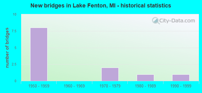
- New bridges - historical statistics
- 81950-1959
- 21970-1979
- 11980-1989
- 11990-1999


- Bridge Condition - Deck
- 25.0%Good
- 25.0%Satisfactory
- 25.0%Fair
- 25.0%Poor

- Bridge Condition - Superstructure
- 25.0%Good
- 75.0%Fair

- Bridge Condition - Substructure
- 25.0%Good
- 75.0%Satisfactory

- Bridge Condition - Channel
- 25.0%Good
- 75.0%Satisfactory

- Bridge Condition - Culverts
- 25.0%Good
- 50.0%Satisfactory
- 25.0%Fair
Find on map >> Show street view
Structure Number: 2478, Location: 1.6 MI N OF FENTON (Lat: 42.841039, Lng: -83.736244), Route carried "on" structure: County highway , Year Built: 1957, Year Reconstructed: 1994, Status: Open, Structure Length: 7.25m (23.79ft), Average Daily Traffic: 2,669 (year 1994), Truck Traffic: 2%, Average Future Daily Traffic: 4,800 (year 2016), Design Load: H 15, Features Intersected: US-23, Facility Carried by Structure: LAHRING RD
Minimum Vertical Clearance: 30.48m (100.00ft), Kilometerpoint: 15.486, Lanes on structure: 2, Lanes under structure: 4, Owner: State Highway Agency, Approaching Roadway Width: 10.9m (35.8ft), Skew: 1 degrees, Material/Design: Steel, Design/Construction: Stringer/Multi-beam, Number Of Spans In Main Unit: 4, Length of Maximum Span: 19.2m (63.0ft), Curb or Sidewalk Widths: Left: 0.7m (2.3ft), Right: 0.7m (2.3ft), Curb-To-Curb Width: 7.9m (25.9ft), Out-to-Out Width: 10.1m (33.1ft)
Condition: Deck: Good, Superstructure: Good, Substructure: Good, Operating Rating: 62.2 metric tons, Method Used To Determine Operating Rating: Load Factor (LF) rating reported by rating factor (RF) method using MS18 loading, Inventory Rating: 32.4 metric tons, Method Used To Determine Inventory Rating: Load Factor (LF) rating reported by rating factor (RF) method using MS18 loading, Structural Evaluation: Better than present minimum criteria, Deck Geometry: High priority of corrective action, Underclear: High priority of replacement, Approach Roadway Alignment: Equal to present minimum criteria, Length Of Structure Improvement: 7.26m (23.82ft), Designated Inspection Frequency: Every 24 months, Inspection Date: August 2021, Bridge Improvement Cost: $1,129,000, Roadway Improvement Cost: $8,000, Total Project Cost: $97,000, Deck Structure Type: Concrete Cast-file-Place, Wearing Surface/Protective System: Wearing Surface: Monolithic Concrete, Deck Protection: Epoxy Coated Reinforcing
Find on map >> Show street view
Structure Number: 2479, Location: 3.2 MI N OF FENTON (Lat: 42.863019, Lng: -83.739678), Route carried "on" structure: County highway 2541, Year Built: 1957, Status: Open, Structure Length: 6.82m (22.38ft), Average Daily Traffic: 9,650 (year 1996), Truck Traffic: 5%, Average Future Daily Traffic: 17,430 (year 2016), Design Load: H 15, Features Intersected: US-23, Facility Carried by Structure: THOMPSON RD
Minimum Vertical Clearance: 30.48m (100.00ft), Kilometerpoint: 2.787, Lanes on structure: 2, Lanes under structure: 6, Owner: State Highway Agency, Approaching Roadway Width: 11.5m (37.7ft), Material/Design: Steel, Design/Construction: Stringer/Multi-beam, Number Of Spans In Main Unit: 4, Length of Maximum Span: 18.2m (59.7ft), Curb or Sidewalk Widths: Left: 0.7m (2.3ft), Right: 0.7m (2.3ft), Curb-To-Curb Width: 7.9m (25.9ft), Out-to-Out Width: 10.1m (33.1ft)
Condition: Deck: Fair, Superstructure: Fair, Substructure: Satisfactory, Operating Rating: 52.5 metric tons, Method Used To Determine Operating Rating: Load Factor (LF) rating reported by rating factor (RF) method using MS18 loading, Inventory Rating: 31.4 metric tons, Method Used To Determine Inventory Rating: Load Factor (LF) rating reported by rating factor (RF) method using MS18 loading, Structural Evaluation: Somewhat better than minimum adequacy, Deck Geometry: High priority of corrective action, Underclear: Meets minimum limits, Approach Roadway Alignment: Somewhat better than minimum adequacy, Length Of Structure Improvement: 6.83m (22.41ft), Designated Inspection Frequency: Every 8 months, Inspection Date: Febuary 2022, Bridge Improvement Cost: $1,062,000, Roadway Improvement Cost: $14,000, Total Project Cost: $167,000, Deck Structure Type: Concrete Cast-file-Place, Wearing Surface/Protective System: Wearing Surface: Bituminous
Find on map >> Show street view
Structure Number: 248, Location: 5.0 MI N OF FENTON (Lat: 42.885172, Lng: -83.738808), Route carried "on" structure: County highway 2524, Year Built: 1957, Status: Open, Structure Length: 5.48m (17.98ft), Average Daily Traffic: 3,655 (year 1996), Truck Traffic: 3%, Average Future Daily Traffic: 6,620 (year 2016), Design Load: H 15, Features Intersected: US-23, Facility Carried by Structure: BALDWIN RD
Minimum Vertical Clearance: 30.48m (100.00ft), Kilometerpoint: 15.424, Lanes on structure: 2, Lanes under structure: 4, Owner: State Highway Agency, Approaching Roadway Width: 11.8m (38.7ft), Material/Design: Steel, Design/Construction: Stringer/Multi-beam, Number Of Spans In Main Unit: 4, Length of Maximum Span: 18.2m (59.7ft), Curb or Sidewalk Widths: Left: 0.7m (2.3ft), Right: 0.7m (2.3ft), Curb-To-Curb Width: 7.9m (25.9ft), Out-to-Out Width: 10.1m (33.1ft)
Condition: Deck: Satisfactory, Superstructure: Fair, Substructure: Satisfactory, Operating Rating: 46.7 metric tons, Method Used To Determine Operating Rating: Load Factor (LF) rating reported by rating factor (RF) method using MS18 loading, Inventory Rating: 27.9 metric tons, Method Used To Determine Inventory Rating: Load Factor (LF) rating reported by rating factor (RF) method using MS18 loading, Structural Evaluation: Somewhat better than minimum adequacy, Deck Geometry: High priority of corrective action, Underclear: Somewhat better than minimum adequacy, Approach Roadway Alignment: Equal to present desirable criteria, Length Of Structure Improvement: 5.49m (18.01ft), Designated Inspection Frequency: Every 24 months, Inspection Date: Febuary 2022, Bridge Improvement Cost: $172,000, Roadway Improvement Cost: $9,000, Total Project Cost: $102,000, Deck Structure Type: Concrete Cast-file-Place, Wearing Surface/Protective System: Wearing Surface: Latex Concrete
Find on map >> Show street view
Structure Number: 2481, Location: 6.3 MI N OF FENTON (Lat: 42.902722, Lng: -83.730083), Route carried "on" structure: County highway 2541, Year Built: 1957, Status: Open, Structure Length: 9.68m (31.76ft), Average Daily Traffic: 5,326 (year 1996), Truck Traffic: 3%, Average Future Daily Traffic: 9,620 (year 2016), Design Load: H 20, Features Intersected: US-23, Facility Carried by Structure: TORREY RD
Minimum Vertical Clearance: 30.48m (100.00ft), Kilometerpoint: 10.984, Lanes on structure: 2, Lanes under structure: 6, Owner: State Highway Agency, Approaching Roadway Width: 12.2m (40.0ft), Skew: 4 degrees, Material/Design: Steel, Design/Construction: Stringer/Multi-beam, Number Of Spans In Main Unit: 4, Length of Maximum Span: 25.5m (83.7ft), Curb-To-Curb Width: 7.9m (25.9ft), Out-to-Out Width: 10.2m (33.5ft)
Condition: Deck: Poor, Superstructure: Fair, Substructure: Satisfactory, Operating Rating: 75.2 metric tons, Method Used To Determine Operating Rating: Load Factor (LF) rating reported by rating factor (RF) method using MS18 loading, Inventory Rating: 45.0 metric tons, Method Used To Determine Inventory Rating: Load Factor (LF) rating reported by rating factor (RF) method using MS18 loading, Structural Evaluation: Somewhat better than minimum adequacy, Deck Geometry: High priority of corrective action, Underclear: Somewhat better than minimum adequacy, Approach Roadway Alignment: Somewhat better than minimum adequacy, Length Of Structure Improvement: 9.70m (31.82ft), Designated Inspection Frequency: Every 24 months, Inspection Date: November 2021, Bridge Improvement Cost: $1,508,000, Roadway Improvement Cost: $21,000, Total Project Cost: $246,000, Deck Structure Type: Concrete Cast-file-Place, Wearing Surface/Protective System: Wearing Surface: Bituminous, Membrane: Preformed Fabric
Find on map >> Show street view
Structure Number: 2745, Location: SOUTH OF COOK ROAD (Lat: 42.900042, Lng: -83.691775), Route carried "on" structure: County highway 2002, Year Built: 1981, Status: Open, Structure Length: 0.85m (2.79ft), Average Daily Traffic: 8,961 (year 2007), Truck Traffic: 5%, Average Future Daily Traffic: 16,185 (year 2027), Design Load: HS 20+Mod, Features Intersected: SWARTZ CREEK, Facility Carried by Structure: FENTON ROAD
Minimum Vertical Clearance: 30.48m (100.00ft), Kilometerpoint: 12.064, Lanes on structure: 4, Owner: County Highway Agency, Approaching Roadway Width: 14.9m (48.9ft), Skew: 4 degrees, Material/Design: Steel, Design/Construction: Culvert, Number Of Spans In Main Unit: 2, Length of Maximum Span: 3.6m (11.8ft), Curb-To-Curb Width: 15.5m (50.9ft), Out-to-Out Width: 16.0m (52.5ft)
Condition: Channel: Satisfactory, Culverts: Satisfactory, Operating Rating: 59.0 metric tons, Method Used To Determine Operating Rating: Load Factor (LF) rating reported by rating factor (RF) method using MS18 loading, Inventory Rating: 35.3 metric tons, Method Used To Determine Inventory Rating: Load Factor (LF) rating reported by rating factor (RF) method using MS18 loading, Structural Evaluation: Equal to present minimum criteria, Deck Geometry: Meets minimum limits, Waterway Adequacy: Superior to present desirable criteria, Approach Roadway Alignment: Superior to present desirable criteria, Designated Inspection Frequency: Every 24 months, Inspection Date: October 2020
Find on map >> Show street view
Structure Number: 2805, Location: 0.6 MI. E. OF TORREY RD. (Lat: 42.900175, Lng: -83.718236), Route carried "on" structure: County highway , Year Built: 1979, Status: Open, Structure Length: 0.82m (2.69ft), Average Daily Traffic: 389 (year 2009), Truck Traffic: 2%, Average Future Daily Traffic: 703 (year 2029), Design Load: HS 20+Mod, Features Intersected: INDIAN CREEK, Facility Carried by Structure: COOK ROAD
Minimum Vertical Clearance: 30.48m (100.00ft), Kilometerpoint: 0.959, Lanes on structure: 2, Owner: County Highway Agency, Approaching Roadway Width: 7.9m (25.9ft), Material/Design: Steel, Design/Construction: Culvert, Number Of Spans In Main Unit: 2, Length of Maximum Span: 3.6m (11.8ft), Curb-To-Curb Width: 7.9m (25.9ft), Out-to-Out Width: 18.2m (59.7ft)
Condition: Channel: Satisfactory, Culverts: Satisfactory, Operating Rating: 52.2 metric tons, Method Used To Determine Operating Rating: Load Factor (LF) rating reported by rating factor (RF) method using MS18 loading, Inventory Rating: 46.0 metric tons, Method Used To Determine Inventory Rating: Load Factor (LF) rating reported by rating factor (RF) method using MS18 loading, Structural Evaluation: Equal to present minimum criteria, Deck Geometry: Somewhat better than minimum adequacy, Waterway Adequacy: Equal to present minimum criteria, Approach Roadway Alignment: Better than present minimum criteria, Designated Inspection Frequency: Every 24 months, Inspection Date: October 2020
Find on map >> Show street view
Structure Number: 8199, Location: SOUTH OF KURTZ (Lat: 42.841706, Lng: -83.688578), Route carried "on" structure: County highway , Year Built: 1979, Status: Open, Structure Length: 0.82m (2.69ft), Average Daily Traffic: 304 (year 1997), Truck Traffic: 5%, Average Future Daily Traffic: 500 (year 2017), Design Load: HS 20+Mod, Features Intersected: SWARTZ CREEK, Facility Carried by Structure: GAGE RD
Minimum Vertical Clearance: 30.48m (100.00ft), Kilometerpoint: 0.055, Lanes on structure: 2, Owner: County Highway Agency, Approaching Roadway Width: 7.9m (25.9ft), Skew: 1 degrees, Material/Design: Steel, Design/Construction: Culvert, Number Of Spans In Main Unit: 2, Length of Maximum Span: 3.6m (11.8ft), Curb or Sidewalk Widths: Left: 0.9m (3.0ft), Right: 0.9m (3.0ft), Out-to-Out Width: 11.5m (37.7ft)
Condition: Channel: Satisfactory, Culverts: Fair, Operating Rating: 62.5 metric tons, Method Used To Determine Operating Rating: Load Factor (LF) rating reported by rating factor (RF) method using MS18 loading, Inventory Rating: 57.7 metric tons, Method Used To Determine Inventory Rating: Load Factor (LF) rating reported by rating factor (RF) method using MS18 loading, Structural Evaluation: Somewhat better than minimum adequacy, Waterway Adequacy: Equal to present desirable criteria, Approach Roadway Alignment: Equal to present minimum criteria, Designated Inspection Frequency: Every 24 months, Inspection Date: June 2020
Find on map >> Show street view
Structure Number: 12832, Location: 0.2 MI. E. OF TORREY RD. (Lat: 42.900069, Lng: -83.725900), Route carried "on" structure: County highway , Year Built: 1998, Status: Open, Structure Length: 0.79m (2.59ft), Average Daily Traffic: 389 (year 2009), Truck Traffic: 2%, Average Future Daily Traffic: 703 (year 2029), Features Intersected: DAWE DRAIN, Facility Carried by Structure: COOK ROAD
Minimum Vertical Clearance: 30.48m (100.00ft), Kilometerpoint: 0.333, Lanes on structure: 2, Owner: County Highway Agency, Approaching Roadway Width: 9.1m (29.9ft), Skew: 4 degrees, Material/Design: Concrete, Design/Construction: Culvert, Number Of Spans In Main Unit: 1, Length of Maximum Span: 7.3m (24.0ft), Curb-To-Curb Width: 8.5m (27.9ft), Out-to-Out Width: 8.6m (28.2ft)
Condition: Channel: Good, Culverts: Good, Operating Rating: 67.4 metric tons, Method Used To Determine Operating Rating: Load Factor (LF) rating reported by rating factor (RF) method using MS18 loading, Inventory Rating: 40.5 metric tons, Method Used To Determine Inventory Rating: Load Factor (LF) rating reported by rating factor (RF) method using MS18 loading, Structural Evaluation: Better than present minimum criteria, Deck Geometry: Equal to present minimum criteria, Waterway Adequacy: Better than present minimum criteria, Approach Roadway Alignment: Equal to present desirable criteria, Designated Inspection Frequency: Every 24 months, Inspection Date: October 2020, Wearing Surface/Protective System: Wearing Surface: Other, Membrane: Other
Find on map >> Show street view
Structure Number: 2478, Location: 1.6 MI N OF FENTON (Lat: 42.841039, Lng: -83.736244), Route carried "under" structure: US 23, Year Built: 1957, Structure Length: 0. m, Average Daily Traffic: 47,154 (year 2007), Truck Traffic: 9%, Features Intersected: US-23, Facility Carried by Structure: LAHRING RD
Minimum Vertical Clearance: 4.39m (14.40ft), Kilometerpoint: 7.031, Lanes on structure: 2, Lanes under structure: 4, Material/Design: Steel, Design/Construction: Stringer/Multi-beam, Length of Maximum Span: 19.2m (63.0ft)
Find on map >> Show street view
Structure Number: 2479, Location: 3.2 MI N OF FENTON (Lat: 42.863019, Lng: -83.739678), Route carried "under" structure: US 23, Year Built: 1957, Structure Length: 0. m, Average Daily Traffic: 48,826 (year 2007), Truck Traffic: 9%, Features Intersected: US-23, Facility Carried by Structure: THOMPSON RD
Minimum Vertical Clearance: 5.00m (16.40ft), Kilometerpoint: 9.513, Lanes on structure: 2, Lanes under structure: 6, Material/Design: Steel, Design/Construction: Stringer/Multi-beam, Length of Maximum Span: 18.2m (59.7ft)
Find on map >> Show street view
Structure Number: 248, Location: 5.0 MI N OF FENTON (Lat: 42.885172, Lng: -83.738808), Route carried "under" structure: US 23, Year Built: 1957, Structure Length: 0. m, Average Daily Traffic: 48,826 (year 2007), Truck Traffic: 9%, Features Intersected: US-23, Facility Carried by Structure: BALDWIN RD
Minimum Vertical Clearance: 4.95m (16.24ft), Kilometerpoint: 11.977, Lanes on structure: 2, Lanes under structure: 4, Material/Design: Steel, Design/Construction: Stringer/Multi-beam, Length of Maximum Span: 18.2m (59.7ft)
Find on map >> Show street view
Structure Number: 2481, Location: 6.3 MI N OF FENTON (Lat: 42.902722, Lng: -83.730083), Route carried "under" structure: US 23, Year Built: 1957, Structure Length: 0. m, Average Daily Traffic: 57,050 (year 2019), Truck Traffic: 9%, Features Intersected: US-23, Facility Carried by Structure: TORREY RD
Minimum Vertical Clearance: 5.13m (16.83ft), Kilometerpoint: 14.182, Lanes on structure: 2, Lanes under structure: 6, Material/Design: Steel, Design/Construction: Stringer/Multi-beam, Length of Maximum Span: 25.5m (83.7ft)