Bridge Statistics for Lake City, Michigan (MI)
Condition, Traffic, Stress, Structural Evaluation, Project Costs
- National Bridge Inventory (NBI) Statistics
- 13Number of bridges
- 69ft / 20.8mTotal length
- $189,000Total costs
- 50,421Total average daily traffic
- 3,369Total average daily truck traffic
- 67,575Total future (year 2018) average daily traffic
- National Bridge Inventory (NBI) Registered Bridges for Lake City
- No street view available for this location
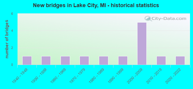
- New bridges - historical statistics
- 11940-1949
- 11950-1959
- 11960-1969
- 11970-1979
- 11980-1989
- 11990-1999
- 52000-2009
- 12010-2019
- 12020-2022


- Bridge Condition - Deck
- 18.2%Very good
- 45.5%Good
- 36.4%Satisfactory

- Bridge Condition - Superstructure
- 36.4%Very good
- 36.4%Good
- 27.3%Satisfactory

- Bridge Condition - Substructure
- 27.3%Very good
- 45.5%Good
- 27.3%Satisfactory

- Bridge Condition - Channel
- 7.7%Very good
- 38.5%Good
- 46.2%Satisfactory
- 7.7%Fair
Find on map >> Show street view
Structure Number: 99, Location: AT JCT OF US-31SB&I-196WB (Lat: 42.730444, Lng: -86.148583), Route carried "on" structure: Interstate 196, Year Built: 2021, Status: Open, Structure Length: 0.91m (2.99ft), Average Daily Traffic: 13,120 (year 2007), Truck Traffic: 8%, Average Future Daily Traffic: 12,792 (year 2018), Design Load: Greater than HL93, Features Intersected: KUIPERS DRAIN
Minimum Vertical Clearance: 30.48m (100.00ft), Kilometerpoint: 2.710, Lanes on structure: 4, Base Highway Network: Yes (Inventory Route: 79, Subroute: 4), Owner: State Highway Agency, Approaching Roadway Width: 20.1m (65.9ft), Skew: 2 degrees, Material/Design: Concrete, Design/Construction: Culvert, Number Of Spans In Main Unit: 1, Length of Maximum Span: 9.1m (29.9ft)
Condition: Channel: Very good, Culverts: Very good, Operating Rating: 68.4 metric tons, Method Used To Determine Operating Rating: Load and Resistance Factor Rating (LRFR) rating reported by rating factor(RF) method using HL-93 loadings, Inventory Rating: 52.8 metric tons, Method Used To Determine Inventory Rating: Load and Resistance Factor Rating (LRFR) rating reported by rating factor(RF) method using HL-93 loadings, Structural Evaluation: Equal to present desirable criteria, Waterway Adequacy: Better than present minimum criteria, Approach Roadway Alignment: Equal to present desirable criteria, Designated Inspection Frequency: Every 24 months, Inspection Date: December 2021, Wearing Surface/Protective System: Wearing Surface: Low Slump Concrete
Find on map >> Show street view
Structure Number: 7059, Location: SECTION 21/22 T22N R7W (Lat: 44.288361, Lng: -85.154997), Route carried "on" structure: County highway , Year Built: 2003, Status: Open, Structure Length: 0.67m (2.20ft), Average Daily Traffic: 56 (year 2007), Average Future Daily Traffic: 100 (year 2027), Design Load: HS 20+Mod, Features Intersected: MOSQUITO CREEK, Facility Carried by Structure: BURKETT ROAD
Minimum Vertical Clearance: 30.48m (100.00ft), Kilometerpoint: 5.169, Lanes on structure: 2, Owner: County Highway Agency, Approaching Roadway Width: 4.9m (16.1ft), Material/Design: Wood or Timber, Design/Construction: Slab, Number Of Spans In Main Unit: 1, Length of Maximum Span: 6.4m (21.0ft), Curb-To-Curb Width: 5.5m (18.0ft), Out-to-Out Width: 7.3m (24.0ft)
Condition: Deck: Very good, Superstructure: Very good, Substructure: Very good, Channel: Good, Operating Rating: 53.8 metric tons, Method Used To Determine Operating Rating: Allowable Stress (AS) rating reported by rating factor (RF) method using MS18 loading, Inventory Rating: 38.6 metric tons, Method Used To Determine Inventory Rating: Allowable Stress (AS) rating reported by rating factor (RF) method using MS18 loading, Structural Evaluation: Equal to present desirable criteria, Deck Geometry: Meets minimum limits, Waterway Adequacy: Better than present minimum criteria, Approach Roadway Alignment: Equal to present desirable criteria, Designated Inspection Frequency: Every 24 months, Inspection Date: May 2021, Deck Structure Type: Wood or Timber, Wearing Surface/Protective System: Wearing Surface: Wood or Timber
Find on map >> Show street view
Structure Number: 9896, Location: 0.3 MI N OF MACOMB COL (Lat: 42.900992, Lng: -82.769425), Route carried "on" structure: State highway 19, Year Built: 2005, Status: Open, Structure Length: 2.80m (9.19ft), Average Daily Traffic: 7,305 (year 2007), Truck Traffic: 6%, Average Future Daily Traffic: 9,774 (year 2018), Design Load: HS 25 or greater, Features Intersected: BELLE RIVER
Minimum Vertical Clearance: 30.48m (100.00ft), Kilometerpoint: 0.499, Lanes on structure: 4, Base Highway Network: Yes (Inventory Route: 96, Subroute: 7), Owner: State Highway Agency, Approaching Roadway Width: 12.2m (40.0ft), Material/Design: Prestressed concrete, Design/Construction: Stringer/Multi-beam, Number Of Spans In Main Unit: 1, Length of Maximum Span: 26.2m (86.0ft), Curb or Sidewalk Widths: Left: 1.8m (5.9ft), Right: 1.8m (5.9ft), Curb-To-Curb Width: 12.2m (40.0ft), Out-to-Out Width: 16.6m (54.5ft)
Condition: Deck: Good, Superstructure: Good, Substructure: Good, Channel: Fair, Operating Rating: 91.0 metric tons, Method Used To Determine Operating Rating: Load Factor (LF) rating reported by rating factor (RF) method using MS18 loading, Inventory Rating: 41.1 metric tons, Method Used To Determine Inventory Rating: Load Factor (LF) rating reported by rating factor (RF) method using MS18 loading, Structural Evaluation: Better than present minimum criteria, Deck Geometry: High priority of replacement, Waterway Adequacy: Equal to present desirable criteria, Approach Roadway Alignment: Equal to present minimum criteria, Designated Inspection Frequency: Every 24 months, Inspection Date: May 2020, Deck Structure Type: Concrete Cast-file-Place, Wearing Surface/Protective System: Wearing Surface: Monolithic Concrete, Deck Protection: Epoxy Coated Reinforcing
Find on map >> Show street view
Structure Number: 9901, Location: 1.7 MI N OF M-21 (Lat: 43.020800, Lng: -82.762147), Route carried "on" structure: State highway 19, Year Built: 1987, Status: Open, Structure Length: 1.28m (4.20ft), Average Daily Traffic: 3,977 (year 2007), Truck Traffic: 10%, Average Future Daily Traffic: 8,954 (year 2018), Design Load: HS 25 or greater, Features Intersected: SULLIVAN DRAIN
Minimum Vertical Clearance: 30.48m (100.00ft), Kilometerpoint: 12.230, Lanes on structure: 2, Base Highway Network: Yes (Inventory Route: 96, Subroute: 5), Owner: State Highway Agency, Approaching Roadway Width: 12.2m (40.0ft), Material/Design: Prestressed concrete, Design/Construction: Stringer/Multi-beam, Number Of Spans In Main Unit: 1, Length of Maximum Span: 12.0m (39.4ft), Curb-To-Curb Width: 14.6m (47.9ft), Out-to-Out Width: 15.6m (51.2ft)
Condition: Deck: Satisfactory, Superstructure: Very good, Substructure: Satisfactory, Channel: Good, Operating Rating: 53.1 metric tons, Method Used To Determine Operating Rating: Load Factor (LF) rating reported by rating factor (RF) method using MS18 loading, Inventory Rating: 32.4 metric tons, Method Used To Determine Inventory Rating: Load Factor (LF) rating reported by rating factor (RF) method using MS18 loading, Structural Evaluation: Equal to present minimum criteria, Deck Geometry: Superior to present desirable criteria, Waterway Adequacy: Equal to present desirable criteria, Approach Roadway Alignment: Equal to present desirable criteria, Designated Inspection Frequency: Every 24 months, Inspection Date: November 2021, Deck Structure Type: Concrete Cast-file-Place, Wearing Surface/Protective System: Wearing Surface: Epoxy Overlay, Deck Protection: Epoxy Coated Reinforcing
Find on map >> Show street view
Structure Number: 9902, Location: 2.8 MI N OF M-21 (Lat: 43.034594, Lng: -82.762911), Route carried "on" structure: State highway 19, Year Built: 2008, Status: Open, Structure Length: 0.73m (2.40ft), Average Daily Traffic: 3,977 (year 2007), Truck Traffic: 8%, Average Future Daily Traffic: 6,160 (year 2028), Design Load: HS 25 or greater, Features Intersected: PINE RIVER
Minimum Vertical Clearance: 30.48m (100.00ft), Kilometerpoint: 13.762, Lanes on structure: 2, Base Highway Network: Yes (Inventory Route: 96, Subroute: 5), Owner: State Highway Agency, Approaching Roadway Width: 13.4m (44.0ft), Material/Design: Concrete, Design/Construction: Culvert, Number Of Spans In Main Unit: 1, Length of Maximum Span: 7.3m (24.0ft), Curb-To-Curb Width: 14.0m (45.9ft), Out-to-Out Width: 14.9m (48.9ft)
Condition: Channel: Satisfactory, Culverts: Very good, Operating Rating: 66.8 metric tons, Method Used To Determine Operating Rating: Load Factor (LF), Inventory Rating: 40.0 metric tons, Method Used To Determine Inventory Rating: Load Factor (LF), Structural Evaluation: Equal to present desirable criteria, Deck Geometry: Superior to present desirable criteria, Waterway Adequacy: Equal to present desirable criteria, Approach Roadway Alignment: Equal to present desirable criteria, Designated Inspection Frequency: Every 24 months, Inspection Date: November 2021, Deck Structure Type: Concrete Precast Panels
Find on map >> Show street view
Structure Number: 9903, Location: 0.1 MI S OF M-136 (Lat: 43.072939, Lng: -82.765614), Route carried "on" structure: State highway 19, Year Built: 2008, Status: Open, Structure Length: 3.44m (11.29ft), Average Daily Traffic: 3,977 (year 2007), Truck Traffic: 8%, Average Future Daily Traffic: 6,160 (year 2028), Design Load: HL 93, Features Intersected: MILL CREEK
Minimum Vertical Clearance: 30.48m (100.00ft), Kilometerpoint: 18.062, Lanes on structure: 2, Base Highway Network: Yes (Inventory Route: 96, Subroute: 5), Owner: State Highway Agency, Approaching Roadway Width: 13.4m (44.0ft), Material/Design: Prestressed concrete, Design/Construction: Stringer/Multi-beam, Number Of Spans In Main Unit: 1, Length of Maximum Span: 33.6m (110.2ft), Curb-To-Curb Width: 13.4m (44.0ft), Out-to-Out Width: 14.1m (46.3ft)
Condition: Deck: Very good, Superstructure: Very good, Substructure: Good, Channel: Good, Operating Rating: 91.7 metric tons, Method Used To Determine Operating Rating: Load and Resistance Factor Rating (LRFR) rating reported by rating factor(RF) method using HL-93 loadings, Inventory Rating: 47.0 metric tons, Method Used To Determine Inventory Rating: Load and Resistance Factor Rating (LRFR) rating reported by rating factor(RF) method using HL-93 loadings, Structural Evaluation: Better than present minimum criteria, Deck Geometry: Better than present minimum criteria, Waterway Adequacy: Equal to present desirable criteria, Approach Roadway Alignment: Equal to present desirable criteria, Designated Inspection Frequency: Every 24 months, Inspection Date: November 2021, Deck Structure Type: Concrete Cast-file-Place, Wearing Surface/Protective System: Wearing Surface: Monolithic Concrete, Deck Protection: Epoxy Coated Reinforcing
Find on map >> Show street view
Structure Number: 10258, Location: IN PORT HURON (Lat: 43.023903, Lng: -82.434381), Route carried "on" structure: City street 2012, Year Built: 1955, Status: Open, Structure Length: 1.64m (5.38ft), Average Daily Traffic: 9,072 (year 2012), Truck Traffic: 8%, Average Future Daily Traffic: 10,000 (year 2032), Design Load: HS 20, Features Intersected: CANAL, Facility Carried by Structure: GRATIOT
Minimum Vertical Clearance: 30.48m (100.00ft), Kilometerpoint: 2.870, Lanes on structure: 2, Owner: City or Municipal Highway Agency, Approaching Roadway Width: 11.0m (36.1ft), Material/Design: Steel, Design/Construction: Stringer/Multi-beam, Number Of Spans In Main Unit: 1, Length of Maximum Span: 15.8m (51.8ft), Curb or Sidewalk Widths: Left: 1.5m (4.9ft), Right: 1.5m (4.9ft), Curb-To-Curb Width: 13.4m (44.0ft), Out-to-Out Width: 17.2m (56.4ft)
Condition: Deck: Good, Superstructure: Good, Substructure: Good, Channel: Good, Operating Rating: 97.2 metric tons, Method Used To Determine Operating Rating: Load Factor (LF) rating reported by rating factor (RF) method using MS18 loading, Inventory Rating: 54.1 metric tons, Method Used To Determine Inventory Rating: Load Factor (LF) rating reported by rating factor (RF) method using MS18 loading, Structural Evaluation: Better than present minimum criteria, Deck Geometry: Equal to present minimum criteria, Waterway Adequacy: Equal to present desirable criteria, Approach Roadway Alignment: Equal to present desirable criteria, Length Of Structure Improvement: 1.65m (5.41ft), Designated Inspection Frequency: Every 24 months, Inspection Date: October 2020, Bridge Improvement Cost: $189,000, Total Project Cost: $189,000 ( Estimate for 2015), Deck Structure Type: Concrete Cast-file-Place, Wearing Surface/Protective System: Wearing Surface: Integral Concrete
Find on map >> Show street view
Structure Number: 10259, Location: CITY OF YALE (Lat: 43.129914, Lng: -82.800864), Route carried "on" structure: Business City street , Year Built: 1940, Year Reconstructed: 1995, Status: Open, Structure Length: 1.98m (6.50ft), Average Daily Traffic: 4,157 (year 2016), Truck Traffic: 3%, Average Future Daily Traffic: 5,000 (year 2036), Design Load: HS 20, Features Intersected: MILL CREEK, Facility Carried by Structure: PARK AVENUE
Minimum Vertical Clearance: 30.48m (100.00ft), Kilometerpoint: 12.928, Lanes on structure: 2, Owner: City or Municipal Highway Agency, Approaching Roadway Width: 11.6m (38.1ft), Skew: 3 degrees, Material/Design: Prestressed concrete, Design/Construction: Tee Beam, Number Of Spans In Main Unit: 1, Length of Maximum Span: 19.2m (63.0ft), Curb-To-Curb Width: 10.7m (35.1ft), Out-to-Out Width: 11.5m (37.7ft)
Condition: Deck: Good, Superstructure: Good, Substructure: Satisfactory, Channel: Satisfactory, Operating Rating: 59.9 metric tons, Method Used To Determine Operating Rating: Load Factor (LF) rating reported by rating factor (RF) method using MS18 loading, Inventory Rating: 36.0 metric tons, Method Used To Determine Inventory Rating: Load Factor (LF) rating reported by rating factor (RF) method using MS18 loading, Structural Evaluation: Equal to present minimum criteria, Deck Geometry: Somewhat better than minimum adequacy, Waterway Adequacy: Equal to present desirable criteria, Approach Roadway Alignment: Better than present minimum criteria, Designated Inspection Frequency: Every 24 months, Inspection Date: September 2021, Deck Structure Type: Concrete Precast Panels, Wearing Surface/Protective System: Wearing Surface: Latex Concrete, Deck Protection: Epoxy Coated Reinforcing
Find on map >> Show street view
Structure Number: 10465, Location: SEC 27-34 ELLINGTON TWP (Lat: 43.511617, Lng: -83.288417), Route carried "on" structure: County highway 7966, Year Built: 1971, Status: Open, Structure Length: 0.76m (2.49ft), Average Daily Traffic: 2,095 (year 2009), Average Future Daily Traffic: 3,780 (year 2029), Design Load: HS 20, Features Intersected: BUTTERNUT CREEK DRAIN, Facility Carried by Structure: DECKERVILLE ROAD
Minimum Vertical Clearance: 30.48m (100.00ft), Kilometerpoint: 14.185, Lanes on structure: 2, Owner: County Highway Agency, Approaching Roadway Width: 10.4m (34.1ft), Material/Design: Prestressed concrete, Design/Construction: Box Beam or Girders - Multiple, Number Of Spans In Main Unit: 1, Length of Maximum Span: 7.2m (23.6ft), Curb-To-Curb Width: 10.6m (34.8ft), Out-to-Out Width: 11.1m (36.4ft)
Condition: Deck: Satisfactory, Superstructure: Good, Substructure: Satisfactory, Channel: Satisfactory, Operating Rating: 79.4 metric tons, Method Used To Determine Operating Rating: Load Factor (LF) rating reported by rating factor (RF) method using MS18 loading, Inventory Rating: 47.6 metric tons, Method Used To Determine Inventory Rating: Load Factor (LF) rating reported by rating factor (RF) method using MS18 loading, Structural Evaluation: Equal to present minimum criteria, Deck Geometry: Somewhat better than minimum adequacy, Waterway Adequacy: Better than present minimum criteria, Approach Roadway Alignment: Equal to present desirable criteria, Designated Inspection Frequency: Every 24 months, Inspection Date: June 2021, Deck Structure Type: Concrete Precast Panels, Wearing Surface/Protective System: Wearing Surface: Bituminous
Find on map >> Show street view
Structure Number: 10466, Location: SEC 26-35 ELLINGTON TWP (Lat: 43.512139, Lng: -83.261461), Route carried "on" structure: County highway 7966, Year Built: 1993, Status: Open, Structure Length: 1.83m (6.00ft), Average Daily Traffic: 1,920 (year 2009), Average Future Daily Traffic: 3,470 (year 2029), Design Load: HS 20, Features Intersected: SOUTH BR WHITE CREEK, Facility Carried by Structure: DECKERVILLE ROAD
Minimum Vertical Clearance: 30.48m (100.00ft), Kilometerpoint: 16.364, Lanes on structure: 2, Owner: County Highway Agency, Approaching Roadway Width: 9.8m (32.2ft), Skew: 1 degrees, Material/Design: Prestressed concrete, Design/Construction: Box Beam or Girders - Multiple, Number Of Spans In Main Unit: 1, Length of Maximum Span: 17.8m (58.4ft), Curb-To-Curb Width: 12.5m (41.0ft), Out-to-Out Width: 13.3m (43.6ft)
Condition: Deck: Satisfactory, Superstructure: Satisfactory, Substructure: Good, Channel: Satisfactory, Operating Rating: 57.3 metric tons, Method Used To Determine Operating Rating: Load Factor (LF) rating reported by rating factor (RF) method using MS18 loading, Inventory Rating: 34.3 metric tons, Method Used To Determine Inventory Rating: Load Factor (LF) rating reported by rating factor (RF) method using MS18 loading, Structural Evaluation: Equal to present minimum criteria, Deck Geometry: Better than present minimum criteria, Waterway Adequacy: Better than present minimum criteria, Approach Roadway Alignment: Equal to present desirable criteria, Designated Inspection Frequency: Every 24 months, Inspection Date: June 2021, Deck Structure Type: Concrete Precast Panels, Wearing Surface/Protective System: Wearing Surface: Bituminous, Membrane: Preformed Fabric, Deck Protection: Epoxy Coated Reinforcing
Find on map >> Show street view
Structure Number: 10638, Location: SEC 20 NOVESTA TWP (Lat: 43.531997, Lng: -83.200675), Route carried "on" structure: ServiceCounty highway , Year Built: 2001, Status: Open, Structure Length: 1.86m (6.10ft), Average Daily Traffic: 70 (year 2009), Average Future Daily Traffic: 125 (year 2029), Design Load: HS 20, Features Intersected: WHITE CREEK I/C DRAIN, Facility Carried by Structure: MC ARTHUR ROAD
Minimum Vertical Clearance: 30.48m (100.00ft), Kilometerpoint: 0.486, Lanes on structure: 2, Owner: County Highway Agency, Approaching Roadway Width: 7.3m (24.0ft), Material/Design: Prestressed concrete, Design/Construction: Box Beam or Girders - Multiple, Number Of Spans In Main Unit: 1, Length of Maximum Span: 18.1m (59.4ft), Curb-To-Curb Width: 8.7m (28.5ft), Out-to-Out Width: 9.5m (31.2ft)
Condition: Deck: Satisfactory, Superstructure: Satisfactory, Substructure: Very good, Channel: Satisfactory, Operating Rating: 66.7 metric tons, Method Used To Determine Operating Rating: Load Factor (LF) rating reported by rating factor (RF) method using MS18 loading, Inventory Rating: 40.2 metric tons, Method Used To Determine Inventory Rating: Load Factor (LF) rating reported by rating factor (RF) method using MS18 loading, Structural Evaluation: Equal to present minimum criteria, Deck Geometry: Better than present minimum criteria, Waterway Adequacy: Equal to present desirable criteria, Approach Roadway Alignment: Equal to present desirable criteria, Designated Inspection Frequency: Every 24 months, Inspection Date: July 2021, Deck Structure Type: Concrete Precast Panels, Wearing Surface/Protective System: Wearing Surface: Bituminous, Membrane: Preformed Fabric, Deck Protection: Epoxy Coated Reinforcing
Find on map >> Show street view
Structure Number: 10639, Location: SEC 22-23 NOVESTA TWP (Lat: 43.533872, Lng: -83.151083), Route carried "on" structure: ServiceCounty highway , Year Built: 1962, Status: Open, Structure Length: 1.07m (3.51ft), Average Daily Traffic: 525 (year 2009), Average Future Daily Traffic: 950 (year 2029), Design Load: H 15, Features Intersected: WHITE CREEK I/C DRAIN, Facility Carried by Structure: ENGLEHART ROAD
Minimum Vertical Clearance: 30.48m (100.00ft), Kilometerpoint: 6.962, Lanes on structure: 2, Owner: County Highway Agency, Approaching Roadway Width: 7.9m (25.9ft), Material/Design: Steel, Design/Construction: Stringer/Multi-beam, Number Of Spans In Main Unit: 1, Length of Maximum Span: 9.8m (32.2ft), Curb-To-Curb Width: 7.8m (25.6ft), Out-to-Out Width: 8.3m (27.2ft)
Condition: Deck: Good, Superstructure: Satisfactory, Substructure: Good, Channel: Satisfactory, Operating Rating: 37.6 metric tons, Method Used To Determine Operating Rating: Load Factor (LF) rating reported by rating factor (RF) method using MS18 loading, Inventory Rating: 22.7 metric tons, Method Used To Determine Inventory Rating: Load Factor (LF) rating reported by rating factor (RF) method using MS18 loading, Structural Evaluation: Equal to present minimum criteria, Deck Geometry: Meets minimum limits, Waterway Adequacy: Better than present minimum criteria, Approach Roadway Alignment: Equal to present desirable criteria, Bridge Posting: Required (Relationship of Operating Rating to Maximum Legal Load: 20.0 - 29.9% below), Designated Inspection Frequency: Every 24 months, Inspection Date: July 2021, Deck Structure Type: Concrete Cast-file-Place, Wearing Surface/Protective System: Wearing Surface: Monolithic Concrete
Find on map >> Show street view
Structure Number: 10669, Location: SEC 32 WISNER TWP (Lat: 43.575419, Lng: -83.682950), Route carried "on" structure: ServiceCounty highway , Year Built: 2010, Status: Open, Structure Length: 1.80m (5.91ft), Average Daily Traffic: 170 (year 2010), Average Future Daily Traffic: 310 (year 2030), Design Load: HS 20+Mod, Features Intersected: NORTHWEST DRAIN OUTLET 1, Facility Carried by Structure: OLD STATE ROAD
Minimum Vertical Clearance: 30.48m (100.00ft), Kilometerpoint: 1.337, Lanes on structure: 2, Owner: County Highway Agency, Approaching Roadway Width: 9.1m (29.9ft), Skew: 2 degrees, Material/Design: Prestressed concrete, Design/Construction: Box Beam or Girders - Multiple, Number Of Spans In Main Unit: 1, Length of Maximum Span: 17.6m (57.7ft), Curb-To-Curb Width: 8.7m (28.5ft), Out-to-Out Width: 9.5m (31.2ft)
Condition: Deck: Good, Superstructure: Very good, Substructure: Very good, Channel: Good, Operating Rating: 88.5 metric tons, Method Used To Determine Operating Rating: Load and Resistance Factor Rating (LRFR) rating reported by rating factor(RF) method using HL-93 loadings, Inventory Rating: 68.4 metric tons, Method Used To Determine Inventory Rating: Load and Resistance Factor Rating (LRFR) rating reported by rating factor(RF) method using HL-93 loadings, Structural Evaluation: Equal to present desirable criteria, Deck Geometry: Equal to present minimum criteria, Waterway Adequacy: Meets minimum limits, Approach Roadway Alignment: Meets minimum limits, Designated Inspection Frequency: Every 24 months, Inspection Date: October 2020, Deck Structure Type: Concrete Precast Panels, Wearing Surface/Protective System: Wearing Surface: Bituminous, Membrane: Preformed Fabric