Bridge Statistics for Lake Arthur Estates, Pennsylvania (PA)
Condition, Traffic, Stress, Structural Evaluation, Project Costs
- National Bridge Inventory (NBI) Statistics
- 35Number of bridges
- 279ft / 84.6mTotal length
- $5,742,000Total costs
- 228,110Total average daily traffic
- 30,783Total average daily truck traffic
- National Bridge Inventory (NBI) Registered Bridges for Lake Arthur Estates
- No street view available for this location
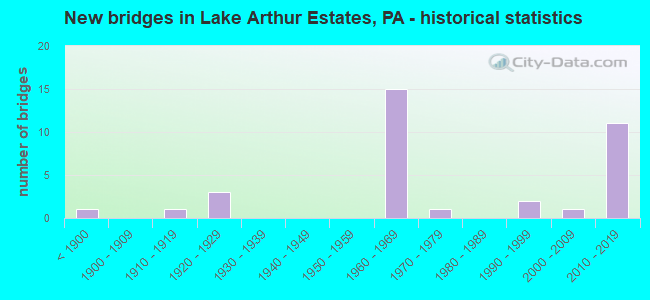
- New bridges - historical statistics
- 1Before 1900
- 11910-1919
- 31920-1929
- 151960-1969
- 11970-1979
- 21990-1999
- 12000-2009
- 112010-2019


- Bridge Condition - Deck
- 27.8%Very good
- 33.3%Good
- 11.1%Satisfactory
- 22.2%Fair
- 5.6%Failed

- Bridge Condition - Superstructure
- 33.3%Very good
- 16.7%Good
- 22.2%Satisfactory
- 5.6%Fair
- 11.1%Poor
- 11.1%Serious

- Bridge Condition - Substructure
- 22.2%Very good
- 27.8%Good
- 16.7%Satisfactory
- 27.8%Fair
- 5.6%Poor

- Bridge Condition - Channel
- 20.0%Very good
- 46.7%Good
- 33.3%Satisfactory
Find on map >> Show street view
Structure Number: 8121, Location: WEST PARK RD NO.2 (Lat: 40.944972, Lng: -80.141936), Route carried "on" structure: State highway , Year Built: 1969, Year Reconstructed: 2010, Status: Open, Structure Length: 4.57m (14.99ft), Average Daily Traffic: 1,584 (year 2021), Truck Traffic: 2%, Average Future Daily Traffic: 1,481 (year 2032), Design Load: HS 20, Features Intersected: SR0422 EB&WB, Facility Carried by Structure: SR4007
Minimum Vertical Clearance: 30+ m (98+ ft), Kilometerpoint: 0.055, Lanes on structure: 2, Lanes under structure: 4, Owner: State Highway Agency, Approaching Roadway Width: 6.4m (21.0ft), Skew: 1 degrees, Material/Design: Prestressed concrete, Design/Construction: Box Beam or Girders - Multiple, Number Of Spans In Main Unit: 1, Number Of Approach Spans: 2, Length of Maximum Span: 25.0m (82.0ft), Curb-To-Curb Width: 9.6m (31.5ft), Out-to-Out Width: 10.2m (33.5ft)
Condition: Deck: Good, Superstructure: Satisfactory, Substructure: Satisfactory, Operating Rating: 64.4 metric tons, Method Used To Determine Operating Rating: Load Factor (LF), Inventory Rating: 35.4 metric tons, Method Used To Determine Inventory Rating: Load Factor (LF), Structural Evaluation: Equal to present minimum criteria, Deck Geometry: Somewhat better than minimum adequacy, Underclear: Meets minimum limits, Approach Roadway Alignment: Equal to present desirable criteria, Length Of Structure Improvement: 9.10m (29.86ft), Designated Inspection Frequency: Every 24 months, Inspection Date: April 2020, Bridge Improvement Cost: $28,000, Roadway Improvement Cost: $81,000, Total Project Cost: $372,000, Deck Structure Type: Concrete Cast-file-Place, Wearing Surface/Protective System: Wearing Surface: Monolithic Concrete, Deck Protection: Epoxy Coated Reinforcing
Find on map >> Show street view
Structure Number: 8122, Location: WEST PARK RD NO.3 (Lat: 40.962875, Lng: -80.130875), Route carried "on" structure: State highway , Year Built: 1969, Year Reconstructed: 2010, Status: Open, Structure Length: 7.41m (24.31ft), Average Daily Traffic: 1,584 (year 2021), Truck Traffic: 2%, Average Future Daily Traffic: 1,481 (year 2032), Design Load: HS 20, Features Intersected: MUDDY CREEK, Facility Carried by Structure: SR4007
Minimum Vertical Clearance: 30+ m (98+ ft), Kilometerpoint: 0.101, Lanes on structure: 2, Owner: State Highway Agency, Approaching Roadway Width: 6.7m (22.0ft), Skew: 2 degrees, Material/Design: Prestressed concrete, Design/Construction: Stringer/Multi-beam, Number Of Spans In Main Unit: 3, Length of Maximum Span: 29.3m (96.1ft), Curb-To-Curb Width: 8.5m (27.9ft), Out-to-Out Width: 9.4m (30.8ft)
Condition: Deck: Good, Superstructure: Satisfactory, Substructure: Satisfactory, Channel: Good, Operating Rating: 75.3 metric tons, Method Used To Determine Operating Rating: Load Factor (LF), Inventory Rating: 16.3 metric tons, Method Used To Determine Inventory Rating: Load Factor (LF), Structural Evaluation: Meets minimum limits, Deck Geometry: Somewhat better than minimum adequacy, Waterway Adequacy: Superior to present desirable criteria, Approach Roadway Alignment: Equal to present desirable criteria, Length Of Structure Improvement: 9.10m (29.86ft), Designated Inspection Frequency: Every 24 months, Inspection Date: April 2020, Bridge Improvement Cost: $172,000, Roadway Improvement Cost: $506,000, Total Project Cost: $2,320,000 ( Estimate for 2020), Deck Structure Type: Concrete Cast-file-Place, Wearing Surface/Protective System: Wearing Surface: Monolithic Concrete, Deck Protection: Epoxy Coated Reinforcing
Find on map >> Show street view
Structure Number: 8124, Location: WEST PARK RD NO.5 (Lat: 40.980028, Lng: -80.130047), Route carried "on" structure: State highway , Year Built: 1965, Year Reconstructed: 2010, Status: Open, Structure Length: 8.14m (26.71ft), Average Daily Traffic: 597 (year 2022), Truck Traffic: 7%, Average Future Daily Traffic: 971 (year 2032), Design Load: HS 20, Features Intersected: SR0079 NB&SB, Facility Carried by Structure: SR4007
Minimum Vertical Clearance: 30+ m (98+ ft), Kilometerpoint: 0.179, Lanes on structure: 2, Lanes under structure: 4, Owner: State Highway Agency, Approaching Roadway Width: 8.5m (27.9ft), Skew: 3 degrees, Material/Design: Steel continuous, Design/Construction: Stringer/Multi-beam, Number Of Spans In Main Unit: 5, Length of Maximum Span: 22.6m (74.1ft), Curb or Sidewalk Widths: Left: 0.2m (0.7ft), Right: 0.2m (0.7ft), Curb-To-Curb Width: 8.5m (27.9ft), Out-to-Out Width: 9.6m (31.5ft)
Condition: Deck: Good, Superstructure: Satisfactory, Substructure: Good, Operating Rating: 70.8 metric tons, Method Used To Determine Operating Rating: Load Factor (LF), Inventory Rating: 42.6 metric tons, Method Used To Determine Inventory Rating: Load Factor (LF), Structural Evaluation: Equal to present minimum criteria, Deck Geometry: Somewhat better than minimum adequacy, Underclear: High priority of corrective action, Approach Roadway Alignment: Equal to present desirable criteria, Length Of Structure Improvement: 15.20m (49.87ft), Designated Inspection Frequency: Every 48 months, Inspection Date: August 2020, Bridge Improvement Cost: $26,000, Roadway Improvement Cost: $76,000, Total Project Cost: $349,000, Deck Structure Type: Concrete Cast-file-Place, Wearing Surface/Protective System: Wearing Surface: Monolithic Concrete, Deck Protection: Epoxy Coated Reinforcing
Find on map >> Show street view
Structure Number: 8125, Location: WEST PARK RD NO.6 (Lat: 40.992056, Lng: -80.127261), Route carried "on" structure: State highway , Year Built: 1964, Status: Open, Structure Length: 6.92m (22.70ft), Average Daily Traffic: 597 (year 2022), Truck Traffic: 7%, Average Future Daily Traffic: 971 (year 2032), Design Load: HS 20, Features Intersected: SR0079 NB&SB, Facility Carried by Structure: SR4007
Minimum Vertical Clearance: 30+ m (98+ ft), Kilometerpoint: 0.259, Lanes on structure: 2, Lanes under structure: 4, Owner: State Highway Agency, Approaching Roadway Width: 6.4m (21.0ft), Skew: 1 degrees, Material/Design: Steel continuous, Design/Construction: Stringer/Multi-beam, Number Of Spans In Main Unit: 5, Length of Maximum Span: 18.9m (62.0ft), Curb or Sidewalk Widths: Left: 0.5m (1.6ft), Right: 0.5m (1.6ft), Curb-To-Curb Width: 8.5m (27.9ft), Out-to-Out Width: 10.2m (33.5ft)
Condition: Deck: Fair, Superstructure: Fair, Substructure: Fair, Operating Rating: 55.3 metric tons, Method Used To Determine Operating Rating: Load Factor (LF), Inventory Rating: 32.7 metric tons, Method Used To Determine Inventory Rating: Load Factor (LF), Structural Evaluation: Somewhat better than minimum adequacy, Deck Geometry: Somewhat better than minimum adequacy, Underclear: Meets minimum limits, Approach Roadway Alignment: Equal to present desirable criteria, Length Of Structure Improvement: 12.20m (40.03ft), Designated Inspection Frequency: Every 24 months, Inspection Date: August 2020, Bridge Improvement Cost: $59,000, Roadway Improvement Cost: $174,000, Total Project Cost: $797,000, Deck Structure Type: Concrete Cast-file-Place, Wearing Surface/Protective System: Wearing Surface: Bituminous, Membrane: Preformed Fabric
Find on map >> Show street view
Structure Number: 8268, Location: 0.22 MI N OF T-369 (Lat: 40.972172, Lng: -80.151489), Route carried "on" structure: City street , Year Built: 1925, Status: Posted for load, Structure Length: 1.71m (5.61ft), Average Daily Traffic: 100 (year 2015), Truck Traffic: 9%, Average Future Daily Traffic: 120 (year 2035), Features Intersected: MUDDY CREEK, Facility Carried by Structure: T-348 BOOK ROAD
Minimum Vertical Clearance: 30+ m (98+ ft), Kilometerpoint: 0.000, Lanes on structure: 1, Owner: County Highway Agency, Approaching Roadway Width: 4.3m (14.1ft), Material/Design: Steel, Design/Construction: Truss - Thru, Number Of Spans In Main Unit: 1, Length of Maximum Span: 15.8m (51.8ft), Curb-To-Curb Width: 4.7m (15.4ft), Out-to-Out Width: 5.1m (16.7ft)
Condition: Deck: Good, Superstructure: Poor, Substructure: Fair, Channel: Satisfactory, Operating Rating: 15.4 metric tons, Method Used To Determine Operating Rating: Load Factor (LF), Inventory Rating: 9.1 metric tons, Method Used To Determine Inventory Rating: Load Factor (LF), Structural Evaluation: High priority of replacement, Deck Geometry: Better than present minimum criteria, Waterway Adequacy: Better than present minimum criteria, Approach Roadway Alignment: Better than present minimum criteria, Bridge Posting: Required (Relationship of Operating Rating to Maximum Legal Load: > 39.9% below), Length Of Structure Improvement: 1.70m (5.58ft), Designated Inspection Frequency: Every 24 months, Critical Feature Inspection Frequency: Every 12 months, Other Special Inspection Frequency: Every 12 months, Inspection Date: November 2019, Critical Feature Inspection Date: November 2020, Other Special Inspection Date: November 2020, Bridge Improvement Cost: $28,000, Roadway Improvement Cost: $100,000, Total Project Cost: $380,000, Deck Structure Type: Open Grating
Find on map >> Show street view
Structure Number: 833, Location: 3/4 MI NE OF SR 4007 (Lat: 40.975900, Lng: -80.125600), Route carried "on" structure: State lands road , Year Built: 1972, Status: Open, Structure Length: 0.64m (2.10ft), Average Daily Traffic: 100 (year 2012), Average Future Daily Traffic: 150 (year 2032), Features Intersected: MONINOT RUN, Facility Carried by Structure: NORTH SHORE DRIVE
Minimum Vertical Clearance: 30+ m (98+ ft), Kilometerpoint: 0.000, Lanes on structure: 2, Owner: State Park, Forest, or Reservation Agency, Approaching Roadway Width: 6.1m (20.0ft), Material/Design: Steel, Design/Construction: Culvert, Number Of Spans In Main Unit: 1, Length of Maximum Span: 6.4m (21.0ft), Curb or Sidewalk Widths: Left: 0.2m (0.7ft), Right: 0.2m (0.7ft), Curb-To-Curb Width: 10.2m (33.5ft), Out-to-Out Width: 11.1m (36.4ft)
Condition: Channel: Satisfactory, Culverts: Satisfactory, Operating Rating: 43.5 metric tons, Method Used To Determine Operating Rating: Field evaluation and documented engineering judgment, Inventory Rating: 32.7 metric tons, Method Used To Determine Inventory Rating: Field evaluation and documented engineering judgment, Structural Evaluation: Equal to present minimum criteria, Deck Geometry: Superior to present desirable criteria, Waterway Adequacy: Equal to present desirable criteria, Approach Roadway Alignment: Equal to present desirable criteria, Length Of Structure Improvement: 0.80m (2.62ft), Designated Inspection Frequency: Every 24 months, Inspection Date: July 2020, Bridge Improvement Cost: $25,000, Roadway Improvement Cost: $15,000, Total Project Cost: $50,000
Find on map >> Show street view
Structure Number: 2219, Location: SR 0019 OVER MUDDY CREEK (Lat: 40.981742, Lng: -80.169869), Route carried "on" structure: US 19, Year Built: 1990, Status: Open, Structure Length: 3.11m (10.20ft), Average Daily Traffic: 3,907 (year 2022), Truck Traffic: 11%, Average Future Daily Traffic: 4,930 (year 2032), Design Load: HS 20, Features Intersected: MUDDY CREEK, Facility Carried by Structure: PERRY HW
Minimum Vertical Clearance: 30+ m (98+ ft), Kilometerpoint: 1.368, Lanes on structure: 2, Base Highway Network: Yes, Owner: State Highway Agency, Approaching Roadway Width: 12.2m (40.0ft), Skew: 3 degrees, Material/Design: Prestressed concrete, Design/Construction: Stringer/Multi-beam, Number Of Spans In Main Unit: 1, Length of Maximum Span: 30.2m (99.1ft), Curb or Sidewalk Widths: Left: 0.2m (0.7ft), Right: 0.2m (0.7ft), Curb-To-Curb Width: 12.2m (40.0ft), Out-to-Out Width: 13.4m (44.0ft)
Condition: Deck: Good, Superstructure: Very good, Substructure: Good, Channel: Very good, Inventory Rating: 36.3 metric tons, Method Used To Determine Inventory Rating: Load Factor (LF), Structural Evaluation: Better than present minimum criteria, Deck Geometry: Equal to present minimum criteria, Waterway Adequacy: Superior to present desirable criteria, Approach Roadway Alignment: Equal to present desirable criteria, Length Of Structure Improvement: 3.90m (12.80ft), Designated Inspection Frequency: Every 24 months, Inspection Date: June 2020, Deck Structure Type: Concrete Cast-file-Place, Wearing Surface/Protective System: Wearing Surface: Monolithic Concrete, Deck Protection: Epoxy Coated Reinforcing
Find on map >> Show street view
Structure Number: 22388, Location: 1580' NORTH OF SR 1012 (Lat: 40.995211, Lng: -80.189856), Route carried "on" structure: State highway , Year Built: 1961, Status: Open, Structure Length: 0.79m (2.59ft), Average Daily Traffic: 154 (year 2020), Truck Traffic: 4%, Average Future Daily Traffic: 275 (year 2032), Design Load: HS 20, Features Intersected: BRANCH SLIPPERY ROCK CR., Facility Carried by Structure: HARLANSBURG ROAD
Minimum Vertical Clearance: 30+ m (98+ ft), Kilometerpoint: 0.000, Lanes on structure: 2, Owner: State Highway Agency, Approaching Roadway Width: 6.7m (22.0ft), Skew: 3 degrees, Material/Design: Concrete, Design/Construction: Slab, Number Of Spans In Main Unit: 1, Length of Maximum Span: 7.0m (23.0ft), Curb or Sidewalk Widths: Left: 0.5m (1.6ft), Right: 0.5m (1.6ft), Curb-To-Curb Width: 9.8m (32.2ft), Out-to-Out Width: 11.4m (37.4ft)
Condition: Deck: Satisfactory, Superstructure: Good, Substructure: Satisfactory, Channel: Satisfactory, Operating Rating: 49.9 metric tons, Method Used To Determine Operating Rating: Load Factor (LF), Inventory Rating: 29.9 metric tons, Method Used To Determine Inventory Rating: Load Factor (LF), Structural Evaluation: Equal to present minimum criteria, Deck Geometry: Better than present minimum criteria, Waterway Adequacy: Better than present minimum criteria, Approach Roadway Alignment: Equal to present desirable criteria, Length Of Structure Improvement: 0.80m (2.62ft), Designated Inspection Frequency: Every 24 months, Inspection Date: August 2020, Deck Structure Type: Concrete Cast-file-Place, Wearing Surface/Protective System: Wearing Surface: Bituminous
Find on map >> Show street view
Structure Number: 22561, Location: 037020 SLIPPERY ROCK TWP (Lat: 40.952928, Lng: -80.170292), Route carried "on" structure: City street , Year Built: 1875, Status: Posted for load, Structure Length: 3.05m (10.01ft), Average Daily Traffic: 150 (year 2006), Truck Traffic: 5%, Average Future Daily Traffic: 150 (year 2026), Features Intersected: SLIPPERY ROCK CREEK, Facility Carried by Structure: MCCONNELS MILL RD
Minimum Vertical Clearance: 3.83m (12.57ft), Kilometerpoint: 0.000, Lanes on structure: 2, Owner: County Highway Agency, Approaching Roadway Width: 4.3m (14.1ft), Material/Design: Steel, Design/Construction: Girder and Floorbeam System, Number Of Spans In Main Unit: 1, Length of Maximum Span: 27.7m (90.9ft), Curb or Sidewalk Widths: Left: 0.2m (0.7ft), Right: 0.2m (0.7ft), Curb-To-Curb Width: 3.9m (12.8ft), Out-to-Out Width: 4.3m (14.1ft)
Condition: Deck: Fair, Superstructure: Poor, Substructure: Fair, Channel: Good, Operating Rating: 11.8 metric tons, Method Used To Determine Operating Rating: Load Factor (LF), Inventory Rating: 6.4 metric tons, Method Used To Determine Inventory Rating: Load Factor (LF), Structural Evaluation: High priority of corrective action, Deck Geometry: High priority of replacement, Waterway Adequacy: Equal to present desirable criteria, Approach Roadway Alignment: High priority of corrective action, Bridge Posting: Required (Relationship of Operating Rating to Maximum Legal Load: > 39.9% below), Length Of Structure Improvement: 2.90m (9.51ft), Designated Inspection Frequency: Every 24 months, Critical Feature Inspection Frequency: Every 24 months, Other Special Inspection Frequency: Every 12 months, Inspection Date: September 2020, Critical Feature Inspection Date: September 2020, Other Special Inspection Date: September 2021, Bridge Improvement Cost: $5,000, Roadway Improvement Cost: $15,000, Total Project Cost: $70,000, Deck Structure Type: Wood or Timber, Wearing Surface/Protective System: Wearing Surface: Wood or Timber
Find on map >> Show street view
Structure Number: 22562, Location: 037019 SLIPPERY ROCK TWP (Lat: 40.949947, Lng: -80.170325), Route carried "on" structure: City street , Year Built: 1918, Status: Open, Structure Length: 2.19m (7.19ft), Average Daily Traffic: 100 (year 2005), Truck Traffic: 1%, Average Future Daily Traffic: 150 (year 2025), Design Load: HS 20, Features Intersected: UNNAMED STREAM, Facility Carried by Structure: KENNEDY RD
Minimum Vertical Clearance: 30+ m (98+ ft), Kilometerpoint: 0.000, Lanes on structure: 2, Owner: County Highway Agency, Approaching Roadway Width: 5.5m (18.0ft), Material/Design: Steel, Design/Construction: Stringer/Multi-beam, Number Of Spans In Main Unit: 1, Length of Maximum Span: 21.3m (69.9ft), Curb or Sidewalk Widths: Left: 0.2m (0.7ft), Right: 0.2m (0.7ft), Curb-To-Curb Width: 5.5m (18.0ft), Out-to-Out Width: 6.4m (21.0ft)
Condition: Deck: Fair, Superstructure: Satisfactory, Substructure: Fair, Channel: Very good, Operating Rating: 68.9 metric tons, Method Used To Determine Operating Rating: Load Factor (LF), Inventory Rating: 41.7 metric tons, Method Used To Determine Inventory Rating: Load Factor (LF), Structural Evaluation: Somewhat better than minimum adequacy, Deck Geometry: Meets minimum limits, Waterway Adequacy: Superior to present desirable criteria, Approach Roadway Alignment: Meets minimum limits, Length Of Structure Improvement: 2.20m (7.22ft), Designated Inspection Frequency: Every 24 months, Inspection Date: August 2021, Bridge Improvement Cost: $39,000, Roadway Improvement Cost: $114,000, Total Project Cost: $523,000, Deck Structure Type: Concrete Cast-file-Place, Wearing Surface/Protective System: Wearing Surface: Monolithic Concrete
Find on map >> Show street view
Structure Number: 22563, Location: 250' W OF MUDDY CREEK RD (Lat: 40.971567, Lng: -80.181897), Route carried "on" structure: City street , Year Built: 1920, Status: Closed, Structure Length: 5.79m (19.00ft), Features Intersected: SLIPPERY ROCK CREEK, Facility Carried by Structure: OLD ROUTE 422 RT
Minimum Vertical Clearance: 4.27m (14.01ft), Kilometerpoint: 0.000, Lanes on structure: 2, Owner: Town or Township Highway Agency, Approaching Roadway Width: 5.5m (18.0ft), Material/Design: Steel, Design/Construction: Truss - Thru, Number Of Spans In Main Unit: 1, Length of Maximum Span: 56.4m (185.0ft), Curb or Sidewalk Widths: Left: 2.1m (6.9ft), Right: 0.2m (0.7ft), Curb-To-Curb Width: 7.0m (23.0ft), Out-to-Out Width: 7.6m (24.9ft)
Condition: Deck: Failed, Superstructure: Serious, Substructure: Poor, Channel: Good, Waterway Adequacy: Superior to present desirable criteria, Approach Roadway Alignment: Better than present minimum criteria, Bridge Posting: Required (Relationship of Operating Rating to Maximum Legal Load: > 39.9% below), Length Of Structure Improvement: 5.80m (19.03ft), Designated Inspection Frequency: Every 24 months, Inspection Date: June 2020, Bridge Improvement Cost: $57,000, Roadway Improvement Cost: $166,000, Total Project Cost: $764,000, Deck Structure Type: Concrete Cast-file-Place, Wearing Surface/Protective System: Wearing Surface: Bituminous
Find on map >> Show street view
Structure Number: 39531, Location: 50 FT N.W. OF TWP RD 487 (Lat: 41.011397, Lng: -80.177761), Route carried "on" structure: US 19, Year Built: 1997, Status: Open, Structure Length: 7.01m (23.00ft), Average Daily Traffic: 3,808 (year 2022), Truck Traffic: 11%, Average Future Daily Traffic: 4,154 (year 2032), Design Load: HS 20, Features Intersected: SLIPPERY ROCK CREEK, Facility Carried by Structure: PERRY HW
Minimum Vertical Clearance: 30+ m (98+ ft), Kilometerpoint: 4.738, Lanes on structure: 2, Base Highway Network: Yes, Owner: State Highway Agency, Approaching Roadway Width: 9.1m (29.9ft), Skew: 3 degrees, Material/Design: Prestressed concrete continuous, Design/Construction: Stringer/Multi-beam, Number Of Spans In Main Unit: 2, Length of Maximum Span: 34.1m (111.9ft), Curb or Sidewalk Widths: Left: 0.2m (0.7ft), Right: 0.2m (0.7ft), Curb-To-Curb Width: 12.2m (40.0ft), Out-to-Out Width: 13.3m (43.6ft)
Condition: Deck: Satisfactory, Superstructure: Very good, Substructure: Good, Channel: Satisfactory, Operating Rating: 57.2 metric tons, Method Used To Determine Operating Rating: Load and Resistance Factor (LRFR), Inventory Rating: 43.5 metric tons, Method Used To Determine Inventory Rating: Load and Resistance Factor (LRFR), Structural Evaluation: Better than present minimum criteria, Deck Geometry: Equal to present minimum criteria, Waterway Adequacy: Superior to present desirable criteria, Approach Roadway Alignment: Equal to present desirable criteria, Length Of Structure Improvement: 7.00m (22.97ft), Designated Inspection Frequency: Every 48 months, Inspection Date: July 2018, Deck Structure Type: Concrete Cast-file-Place, Wearing Surface/Protective System: Wearing Surface: Monolithic Concrete, Membrane: Other, Deck Protection: Epoxy Coated Reinforcing
Find on map >> Show street view
Structure Number: 41936, Location: 275' NORTH OF SR 422 (Lat: 40.969486, Lng: -80.187003), Route carried "on" structure: City street 7212, Year Built: 1921, Status: Posted for load, Structure Length: 1.13m (3.71ft), Average Daily Traffic: 300 (year 2019), Truck Traffic: 1%, Average Future Daily Traffic: 500 (year 2039), Design Load: HS 25 or greater, Features Intersected: TRIB SLIPPERY ROCK CREEK, Facility Carried by Structure: T741 Old Route 422
Minimum Vertical Clearance: 30+ m (98+ ft), Kilometerpoint: 0.000, Lanes on structure: 2, Owner: Town or Township Highway Agency, Approaching Roadway Width: 5.8m (19.0ft), Material/Design: Concrete, Design/Construction: Tee Beam, Number Of Spans In Main Unit: 1, Length of Maximum Span: 11.0m (36.1ft), Curb-To-Curb Width: 7.3m (24.0ft), Out-to-Out Width: 7.9m (25.9ft)
Condition: Deck: Fair, Superstructure: Serious, Substructure: Fair, Channel: Satisfactory, Operating Rating: 14.5 metric tons, Method Used To Determine Operating Rating: Load Factor (LF), Inventory Rating: 9.1 metric tons, Method Used To Determine Inventory Rating: Load Factor (LF), Structural Evaluation: High priority of corrective action, Deck Geometry: Somewhat better than minimum adequacy, Waterway Adequacy: Superior to present desirable criteria, Approach Roadway Alignment: Equal to present desirable criteria, Bridge Posting: Required (Relationship of Operating Rating to Maximum Legal Load: > 39.9% below), Length Of Structure Improvement: 1.40m (4.59ft), Designated Inspection Frequency: Every 24 months, Other Special Inspection Frequency: Every 12 months, Inspection Date: June 2020, Other Special Inspection Date: June 2021, Bridge Improvement Cost: $9,000, Roadway Improvement Cost: $25,000, Total Project Cost: $117,000, Deck Structure Type: Concrete Cast-file-Place, Wearing Surface/Protective System: Wearing Surface: Bituminous
Find on map >> Show street view
Structure Number: 44235, Location: 1.0 MI W OF SR 0019 (Lat: 40.991881, Lng: -80.184400), Route carried "on" structure: State highway , Year Built: 2007, Status: Open, Structure Length: 4.27m (14.01ft), Average Daily Traffic: 329 (year 2022), Truck Traffic: 3%, Average Future Daily Traffic: 480 (year 2032), Design Load: HS 20, Features Intersected: SLIPPERY ROCK CREEK, Facility Carried by Structure: FREW MILL ROAD
Minimum Vertical Clearance: 30+ m (98+ ft), Kilometerpoint: 11.156, Lanes on structure: 2, Owner: State Highway Agency, Approaching Roadway Width: 8.2m (26.9ft), Material/Design: Steel, Design/Construction: Stringer/Multi-beam, Number Of Spans In Main Unit: 1, Length of Maximum Span: 41.1m (134.8ft), Curb or Sidewalk Widths: Left: 0.1m (0.3ft), Right: 0.1m (0.3ft), Curb-To-Curb Width: 7.3m (24.0ft), Out-to-Out Width: 8.3m (27.2ft)
Condition: Deck: Very good, Superstructure: Very good, Substructure: Very good, Channel: Very good, Operating Rating: 70.8 metric tons, Method Used To Determine Operating Rating: Load Factor (LF), Inventory Rating: 41.7 metric tons, Method Used To Determine Inventory Rating: Load Factor (LF), Structural Evaluation: Equal to present desirable criteria, Deck Geometry: Somewhat better than minimum adequacy, Waterway Adequacy: Superior to present desirable criteria, Approach Roadway Alignment: Meets minimum limits, Designated Inspection Frequency: Every 48 months, Inspection Date: August 2020, Deck Structure Type: Concrete Cast-file-Place, Wearing Surface/Protective System: Wearing Surface: Monolithic Concrete, Deck Protection: Epoxy Coated Reinforcing
Find on map >> Show street view
Structure Number: 46494, Location: 1.4mi West of SR 0079 (Lat: 40.967631, Lng: -80.162133), Route carried "on" structure: US 19, Year Built: 2011, Status: Open, Structure Length: 3.51m (11.52ft), Average Daily Traffic: 5,530 (year 2022), Truck Traffic: 12%, Average Future Daily Traffic: 3,372 (year 2032), Design Load: HL 93, Features Intersected: SR 0422 EB & WB
Minimum Vertical Clearance: 30+ m (98+ ft), Kilometerpoint: 34.512, Lanes on structure: 2, Lanes under structure: 4, Base Highway Network: Yes, Owner: State Highway Agency, Approaching Roadway Width: 18.3m (60.0ft), Skew: 3 degrees, Material/Design: Prestressed concrete, Design/Construction: Stringer/Multi-beam, Number Of Spans In Main Unit: 1, Length of Maximum Span: 34.4m (112.9ft), Curb or Sidewalk Widths: Left: 0.2m (0.7ft), Right: 0.2m (0.7ft), Curb-To-Curb Width: 17.1m (56.1ft), Out-to-Out Width: 18.1m (59.4ft)
Condition: Deck: Very good, Superstructure: Good, Substructure: Good, Operating Rating: 69.3 metric tons, Method Used To Determine Operating Rating: Assigned ratings based on Load and Resistance Factor Design (LRFD) reported by rating factor (RF) using HL93 loadings, Inventory Rating: 37.9 metric tons, Method Used To Determine Inventory Rating: Assigned ratings based on Load and Resistance Factor Design (LRFD) reported by rating factor (RF) using HL93 loadings, Structural Evaluation: Better than present minimum criteria, Deck Geometry: Superior to present desirable criteria, Underclear: Equal to present minimum criteria, Approach Roadway Alignment: Equal to present desirable criteria, Designated Inspection Frequency: Every 48 months, Inspection Date: July 2020, Deck Structure Type: Concrete Cast-file-Place, Wearing Surface/Protective System: Wearing Surface: Monolithic Concrete, Deck Protection: Epoxy Coated Reinforcing
Find on map >> Show street view
Structure Number: 47496, Location: 0.4 MI FROM INT W/SR0422 (Lat: 40.969994, Lng: -80.144092), Route carried "on" structure: City street T318, Year Built: 2012, Status: Open, Structure Length: 1.77m (5.81ft), Average Daily Traffic: 100 (year 2014), Truck Traffic: 1%, Average Future Daily Traffic: 125 (year 2034), Design Load: HL 93, Features Intersected: MUDDY CREEK, Facility Carried by Structure: T-318 CURRIE RD
Minimum Vertical Clearance: 30+ m (98+ ft), Kilometerpoint: 0.000, Lanes on structure: 2, Owner: County Highway Agency, Approaching Roadway Width: 7.3m (24.0ft), Material/Design: Prestressed concrete, Design/Construction: Box Beam or Girders - Multiple, Number Of Spans In Main Unit: 1, Length of Maximum Span: 17.1m (56.1ft), Curb-To-Curb Width: 7.5m (24.6ft), Out-to-Out Width: 8.6m (28.2ft)
Condition: Deck: Good, Superstructure: Very good, Substructure: Good, Channel: Good, Operating Rating: 69.7 metric tons, Method Used To Determine Operating Rating: Assigned ratings based on Load and Resistance Factor Design (LRFD) reported by rating factor (RF) using HL93 loadings, Inventory Rating: 43.7 metric tons, Method Used To Determine Inventory Rating: Assigned ratings based on Load and Resistance Factor Design (LRFD) reported by rating factor (RF) using HL93 loadings, Structural Evaluation: Better than present minimum criteria, Deck Geometry: Equal to present minimum criteria, Waterway Adequacy: Better than present minimum criteria, Approach Roadway Alignment: Somewhat better than minimum adequacy, Designated Inspection Frequency: Every 24 months, Inspection Date: October 2020, Deck Structure Type: Concrete Cast-file-Place, Wearing Surface/Protective System: Wearing Surface: Bituminous, Deck Protection: Epoxy Coated Reinforcing
Find on map >> Show street view
Structure Number: 48068, Location: AT SR 79 NB & SR 422 INT. (Lat: 40.962506, Lng: -80.134569), Route carried "on" structure: Interstate 79, Year Built: 2013, Status: Open, Structure Length: 9.02m (29.59ft), Average Daily Traffic: 15,558 (year 2021), Truck Traffic: 14%, Average Future Daily Traffic: 16,140 (year 2032), Design Load: HL 93, Features Intersected: SR 422 EB & WB, MUDDY CR
Minimum Vertical Clearance: 30+ m (98+ ft), Kilometerpoint: 34.482, Lanes on structure: 3, Lanes under structure: 6, Base Highway Network: Yes, Owner: State Highway Agency, Approaching Roadway Width: 13.7m (44.9ft), Material/Design: Steel continuous, Design/Construction: Stringer/Multi-beam, Number Of Spans In Main Unit: 2, Length of Maximum Span: 50.3m (165.0ft), Curb or Sidewalk Widths: Left: 0.2m (0.7ft), Right: 0.2m (0.7ft), Curb-To-Curb Width: 13.7m (44.9ft), Out-to-Out Width: 17.5m (57.4ft)
Condition: Deck: Very good, Superstructure: Good, Substructure: Very good, Channel: Good, Operating Rating: 59.0 metric tons, Method Used To Determine Operating Rating: Assigned ratings based on Load and Resistance Factor Design (LRFD) reported by rating factor (RF) using HL93 loadings, Inventory Rating: 41.1 metric tons, Method Used To Determine Inventory Rating: Assigned ratings based on Load and Resistance Factor Design (LRFD) reported by rating factor (RF) using HL93 loadings, Structural Evaluation: Better than present minimum criteria, Deck Geometry: Meets minimum limits, Underclear: High priority of corrective action, Waterway Adequacy: Equal to present desirable criteria, Approach Roadway Alignment: Equal to present desirable criteria, Designated Inspection Frequency: Every 48 months, Inspection Date: July 2021, Deck Structure Type: Concrete Cast-file-Place, Wearing Surface/Protective System: Wearing Surface: Epoxy Overlay, Membrane: Epoxy, Deck Protection: Epoxy Coated Reinforcing
Find on map >> Show street view
Structure Number: 48763, Location: Intersect. I79 & SR 422 (Lat: 40.962597, Lng: -80.134972), Route carried "on" structure: Interstate 79, Year Built: 2014, Status: Open, Structure Length: 9.02m (29.59ft), Average Daily Traffic: 15,719 (year 2021), Truck Traffic: 14%, Average Future Daily Traffic: 16,243 (year 2032), Design Load: HL 93, Features Intersected: SR 422 EB & WB, MUDDY CR
Minimum Vertical Clearance: 30+ m (98+ ft), Kilometerpoint: 34.506, Lanes on structure: 3, Lanes under structure: 6, Base Highway Network: Yes, Owner: State Highway Agency, Approaching Roadway Width: 13.7m (44.9ft), Skew: 10 degrees, Material/Design: Steel continuous, Design/Construction: Stringer/Multi-beam, Number Of Spans In Main Unit: 2, Length of Maximum Span: 50.3m (165.0ft), Curb or Sidewalk Widths: Left: 0.2m (0.7ft), Right: 0.2m (0.7ft), Curb-To-Curb Width: 13.7m (44.9ft), Out-to-Out Width: 17.5m (57.4ft)
Condition: Deck: Very good, Superstructure: Very good, Substructure: Very good, Channel: Good, Operating Rating: 59.0 metric tons, Method Used To Determine Operating Rating: Assigned ratings based on Load and Resistance Factor Design (LRFD) reported by rating factor (RF) using HL93 loadings, Inventory Rating: 41.1 metric tons, Method Used To Determine Inventory Rating: Assigned ratings based on Load and Resistance Factor Design (LRFD) reported by rating factor (RF) using HL93 loadings, Structural Evaluation: Equal to present desirable criteria, Deck Geometry: Meets minimum limits, Underclear: High priority of corrective action, Waterway Adequacy: Equal to present desirable criteria, Approach Roadway Alignment: Equal to present desirable criteria, Designated Inspection Frequency: Every 48 months, Inspection Date: July 2021, Deck Structure Type: Concrete Cast-file-Place, Wearing Surface/Protective System: Wearing Surface: Epoxy Overlay, Membrane: Epoxy, Deck Protection: Epoxy Coated Reinforcing
Find on map >> Show street view
Structure Number: 5574, Location: 750ft N SR 422 Intersect. (Lat: 40.963111, Lng: -80.129361), Route carried "on" structure: State highway , Year Built: 2018, Status: Open, Structure Length: 4.57m (14.99ft), Average Daily Traffic: 643 (year 2021), Truck Traffic: 5%, Average Future Daily Traffic: 480 (year 2032), Design Load: HL 93, Features Intersected: Muddy Creek, Facility Carried by Structure: SR 4017
Minimum Vertical Clearance: 30+ m (98+ ft), Kilometerpoint: 0.000, Lanes on structure: 2, Owner: State Highway Agency, Approaching Roadway Width: 4.6m (15.1ft), Material/Design: Prestressed concrete, Design/Construction: Stringer/Multi-beam, Number Of Spans In Main Unit: 1, Length of Maximum Span: 44.8m (147.0ft), Curb or Sidewalk Widths: Left: 0.2m (0.7ft), Right: 0.2m (0.7ft), Curb-To-Curb Width: 9.1m (29.9ft), Out-to-Out Width: 10.2m (33.5ft)
Condition: Deck: Very good, Superstructure: Very good, Substructure: Very good, Channel: Good, Operating Rating: 54.8 metric tons, Method Used To Determine Operating Rating: Assigned ratings based on Load and Resistance Factor Design (LRFD) reported by rating factor (RF) using HL93 loadings, Inventory Rating: 33.4 metric tons, Method Used To Determine Inventory Rating: Assigned ratings based on Load and Resistance Factor Design (LRFD) reported by rating factor (RF) using HL93 loadings, Structural Evaluation: Equal to present desirable criteria, Deck Geometry: Equal to present minimum criteria, Waterway Adequacy: Better than present minimum criteria, Approach Roadway Alignment: Equal to present desirable criteria, Designated Inspection Frequency: Every 24 months, Inspection Date: May 2020, Deck Structure Type: Concrete Cast-file-Place, Wearing Surface/Protective System: Wearing Surface: Monolithic Concrete, Deck Protection: Epoxy Coated Reinforcing
Find on map >> Show street view
Structure Number: 7879, Location: BURNSIDE ROAD (Lat: 40.957083, Lng: -80.138003), Route carried "under" structure: Interstate 79, Year Built: 1964, Structure Length: 0. m, Average Daily Traffic: 16,201 (year 2021), Truck Traffic: 14%, Features Intersected: SR0079 NB&SB, Facility Carried by Structure: SR3044 (T-365)
Minimum Vertical Clearance: 5.11m (16.77ft), Kilometerpoint: 33.865, Lanes on structure: 2, Lanes under structure: 2, Material/Design: Prestressed concrete, Design/Construction: Box Beam or Girders - Multiple, Length of Maximum Span: 21.9m (71.9ft)
Find on map >> Show street view
Structure Number: 7879, Location: BURNSIDE ROAD (Lat: 40.957083, Lng: -80.138003), Route carried "under" structure: Interstate 79, Year Built: 1964, Structure Length: 0. m, Average Daily Traffic: 17,025 (year 2021), Truck Traffic: 13%, Features Intersected: SR0079 NB&SB, Facility Carried by Structure: SR3044 (T-365)
Minimum Vertical Clearance: 5.13m (16.83ft), Kilometerpoint: 33.674, Lanes on structure: 2, Lanes under structure: 2, Material/Design: Prestressed concrete, Design/Construction: Box Beam or Girders - Multiple, Length of Maximum Span: 21.9m (71.9ft)
Find on map >> Show street view
Structure Number: 812, Location: WEST PARK RD NO.1 (Lat: 40.944817, Lng: -80.141842), Route carried "under" structure: Interstate 79, Year Built: 1964, Structure Length: 0. m, Average Daily Traffic: 16,201 (year 2021), Truck Traffic: 14%, Features Intersected: SR0079 NB&SB, Facility Carried by Structure: SR4007
Minimum Vertical Clearance: 5.08m (16.67ft), Kilometerpoint: 32.018, Lanes on structure: 2, Lanes under structure: 2, Material/Design: Steel continuous, Design/Construction: Girder and Floorbeam System, Length of Maximum Span: 26.8m (87.9ft)
Find on map >> Show street view
Structure Number: 812, Location: WEST PARK RD NO.1 (Lat: 40.944817, Lng: -80.141842), Route carried "under" structure: Interstate 79, Year Built: 1964, Structure Length: 0. m, Average Daily Traffic: 17,025 (year 2021), Truck Traffic: 13%, Features Intersected: SR0079 NB&SB, Facility Carried by Structure: SR4007
Minimum Vertical Clearance: 5.00m (16.40ft), Kilometerpoint: 31.992, Lanes on structure: 2, Lanes under structure: 2, Material/Design: Steel continuous, Design/Construction: Girder and Floorbeam System, Length of Maximum Span: 26.8m (87.9ft)
Find on map >> Show street view
Structure Number: 8121, Location: WEST PARK RD NO.2 (Lat: 40.944972, Lng: -80.141936), Route carried "under" structure: US 422, Year Built: 1969, Structure Length: 0. m, Average Daily Traffic: 5,717 (year 2022), Truck Traffic: 15%, Features Intersected: SR0422 EB&WB, Facility Carried by Structure: SR4007
Minimum Vertical Clearance: 4.86m (15.94ft), Kilometerpoint: 2.691, Lanes on structure: 2, Lanes under structure: 2, Material/Design: Prestressed concrete, Design/Construction: Box Beam or Girders - Multiple, Length of Maximum Span: 25.0m (82.0ft)
Find on map >> Show street view
Structure Number: 8121, Location: WEST PARK RD NO.2 (Lat: 40.944972, Lng: -80.141936), Route carried "under" structure: US 422, Year Built: 1969, Structure Length: 0. m, Average Daily Traffic: 5,549 (year 2022), Truck Traffic: 15%, Features Intersected: SR0422 EB&WB, Facility Carried by Structure: SR4007
Minimum Vertical Clearance: 4.53m (14.86ft), Kilometerpoint: 2.691, Lanes on structure: 2, Lanes under structure: 2, Material/Design: Prestressed concrete, Design/Construction: Box Beam or Girders - Multiple, Length of Maximum Span: 25.0m (82.0ft)
Find on map >> Show street view
Structure Number: 8124, Location: WEST PARK RD NO.5 (Lat: 40.980028, Lng: -80.130047), Route carried "under" structure: Interstate 79, Year Built: 1965, Structure Length: 0. m, Average Daily Traffic: 15,558 (year 2021), Truck Traffic: 14%, Features Intersected: SR0079 NB&SB, Facility Carried by Structure: SR4007
Minimum Vertical Clearance: 4.98m (16.34ft), Kilometerpoint: 37.718, Lanes on structure: 2, Lanes under structure: 2, Material/Design: Steel continuous, Design/Construction: Stringer/Multi-beam, Length of Maximum Span: 22.6m (74.1ft)
Find on map >> Show street view
Structure Number: 8124, Location: WEST PARK RD NO.5 (Lat: 40.980028, Lng: -80.130047), Route carried "under" structure: Interstate 79, Year Built: 1965, Structure Length: 0. m, Average Daily Traffic: 15,719 (year 2021), Truck Traffic: 14%, Features Intersected: SR0079 NB&SB, Facility Carried by Structure: SR4007
Minimum Vertical Clearance: 5.18m (16.99ft), Kilometerpoint: 37.712, Lanes on structure: 2, Lanes under structure: 2, Material/Design: Steel continuous, Design/Construction: Stringer/Multi-beam, Length of Maximum Span: 22.6m (74.1ft)
Find on map >> Show street view
Structure Number: 8125, Location: WEST PARK RD NO.6 (Lat: 40.992056, Lng: -80.127261), Route carried "under" structure: Interstate 79, Year Built: 1964, Structure Length: 0. m, Average Daily Traffic: 15,558 (year 2021), Truck Traffic: 14%, Features Intersected: SR0079 NB&SB, Facility Carried by Structure: SR4007
Minimum Vertical Clearance: 4.97m (16.31ft), Kilometerpoint: 40.045, Lanes on structure: 2, Lanes under structure: 2, Material/Design: Steel continuous, Design/Construction: Stringer/Multi-beam, Length of Maximum Span: 18.9m (62.0ft)
Find on map >> Show street view
Structure Number: 8125, Location: WEST PARK RD NO.6 (Lat: 40.992056, Lng: -80.127261), Route carried "under" structure: Interstate 79, Year Built: 1964, Structure Length: 0. m, Average Daily Traffic: 15,719 (year 2021), Truck Traffic: 14%, Features Intersected: SR0079 NB&SB, Facility Carried by Structure: SR4007
Minimum Vertical Clearance: 5.10m (16.73ft), Kilometerpoint: 40.032, Lanes on structure: 2, Lanes under structure: 2, Material/Design: Steel continuous, Design/Construction: Stringer/Multi-beam, Length of Maximum Span: 18.9m (62.0ft)
Find on map >> Show street view
Structure Number: 46494, Location: 1.4mi West of SR 0079 (Lat: 40.967631, Lng: -80.162133), Route carried "under" structure: US 422, Year Built: 2011, Structure Length: 0. m, Average Daily Traffic: 6,206 (year 2021), Truck Traffic: 16%, Features Intersected: SR 0422 EB & WB, Facility Carried by Structure: SR 0019 NB & SB
Minimum Vertical Clearance: 5.22m (17.13ft), Kilometerpoint: 0.000, Lanes on structure: 2, Lanes under structure: 2, Material/Design: Prestressed concrete, Design/Construction: Stringer/Multi-beam, Length of Maximum Span: 34.4m (112.9ft)
Find on map >> Show street view
Structure Number: 46494, Location: 1.4mi West of SR 0079 (Lat: 40.967631, Lng: -80.162133), Route carried "under" structure: US 422, Year Built: 2011, Structure Length: 0. m, Average Daily Traffic: 8,240 (year 2022), Truck Traffic: 11%, Features Intersected: SR 0422 EB & WB, Facility Carried by Structure: SR 0019 NB & SB
Minimum Vertical Clearance: 5.38m (17.65ft), Kilometerpoint: 0.000, Lanes on structure: 2, Lanes under structure: 2, Material/Design: Prestressed concrete, Design/Construction: Stringer/Multi-beam, Length of Maximum Span: 34.4m (112.9ft)
Find on map >> Show street view
Structure Number: 48068, Location: AT SR 79 NB & SR 422 INT. (Lat: 40.962506, Lng: -80.134569), Route carried "under" structure: US 422, Year Built: 2013, Structure Length: 0. m, Average Daily Traffic: 5,717 (year 2022), Truck Traffic: 15%, Features Intersected: SR 422 EB & WB, MUDDY CR, Facility Carried by Structure: SR 0079 NB
Minimum Vertical Clearance: 5.05m (16.57ft), Kilometerpoint: 2.102, Lanes on structure: 3, Lanes under structure: 3, Material/Design: Steel continuous, Design/Construction: Stringer/Multi-beam, Length of Maximum Span: 50.3m (165.0ft)
Find on map >> Show street view
Structure Number: 48068, Location: AT SR 79 NB & SR 422 INT. (Lat: 40.962506, Lng: -80.134569), Route carried "under" structure: US 422, Year Built: 2013, Structure Length: 0. m, Average Daily Traffic: 5,549 (year 2022), Truck Traffic: 15%, Features Intersected: SR 422 EB & WB, MUDDY CR, Facility Carried by Structure: SR 0079 NB
Minimum Vertical Clearance: 5.21m (17.09ft), Kilometerpoint: 2.102, Lanes on structure: 3, Lanes under structure: 3, Material/Design: Steel continuous, Design/Construction: Stringer/Multi-beam, Length of Maximum Span: 50.3m (165.0ft)
Find on map >> Show street view
Structure Number: 48763, Location: Intersect. I79 & SR 422 (Lat: 40.962597, Lng: -80.134972), Route carried "under" structure: US 422, Year Built: 2014, Structure Length: 0. m, Average Daily Traffic: 5,717 (year 2022), Truck Traffic: 15%, Features Intersected: SR 422 EB & WB, MUDDY CR, Facility Carried by Structure: SR 0079 SB
Minimum Vertical Clearance: 5.05m (16.57ft), Kilometerpoint: 2.102, Lanes on structure: 3, Lanes under structure: 3, Material/Design: Steel continuous, Design/Construction: Stringer/Multi-beam, Length of Maximum Span: 50.3m (165.0ft)
Find on map >> Show street view
Structure Number: 48763, Location: Intersect. I79 & SR 422 (Lat: 40.962597, Lng: -80.134972), Route carried "under" structure: US 422, Year Built: 2014, Structure Length: 0. m, Average Daily Traffic: 5,549 (year 2022), Truck Traffic: 15%, Features Intersected: SR 422 EB & WB, MUDDY CR, Facility Carried by Structure: SR 0079 SB
Minimum Vertical Clearance: 5.13m (16.83ft), Kilometerpoint: 2.102, Lanes on structure: 3, Lanes under structure: 3, Material/Design: Steel continuous, Design/Construction: Stringer/Multi-beam, Length of Maximum Span: 50.3m (165.0ft)