Bridge Statistics for Laguna Beach, California (CA)
Condition, Traffic, Stress, Structural Evaluation, Project Costs
- National Bridge Inventory (NBI) Statistics
- 25Number of bridges
- 420ft / 128mTotal length
- $626,000Total costs
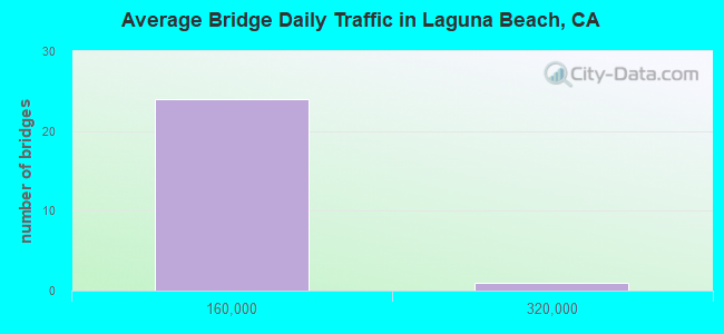
- 880,724Total average daily traffic
- 24,742Total average daily truck traffic
- National Bridge Inventory (NBI) Registered Bridges for Laguna Beach
- No street view available for this location
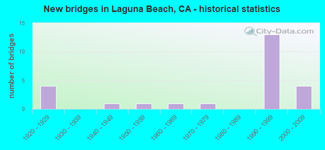
- New bridges - historical statistics
- 41920-1929
- 11940-1949
- 11950-1959
- 11960-1969
- 11970-1979
- 131990-1999
- 42000-2009
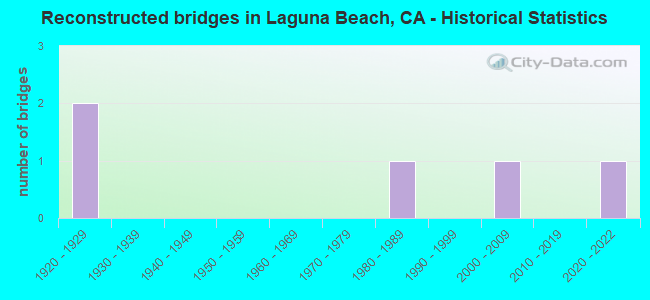
- Reconstructed bridges - Historical Statistics
- 21920-1929
- 01930-1939
- 01940-1949
- 01950-1959
- 01960-1969
- 01970-1979
- 11980-1989
- 01990-1999
- 12000-2009
- 02010-2019
- 12020-2022
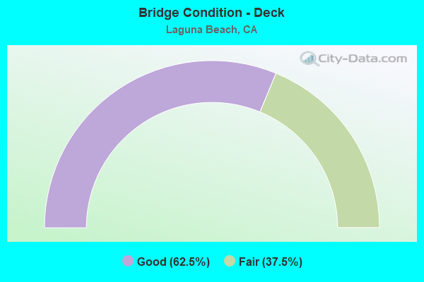
- Bridge Condition - Deck
- 62.5%Good
- 37.5%Fair
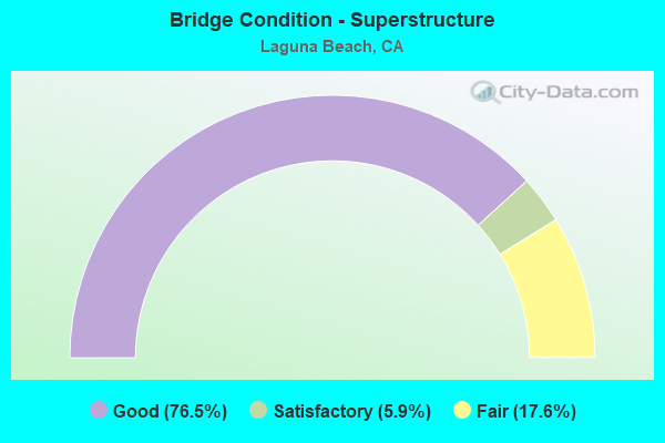
- Bridge Condition - Superstructure
- 76.5%Good
- 5.9%Satisfactory
- 17.6%Fair
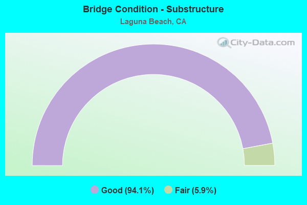
- Bridge Condition - Substructure
- 94.1%Good
- 5.9%Fair
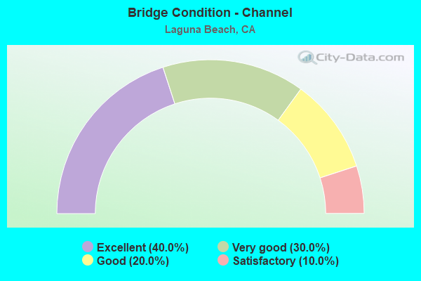
- Bridge Condition - Channel
- 40.0%Excellent
- 30.0%Very good
- 20.0%Good
- 10.0%Satisfactory
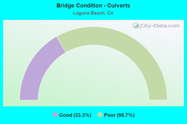
- Bridge Condition - Culverts
- 33.3%Good
- 66.7%Poor
Find on map >> Show street view
Structure Number: 55 0003, Location: 12-ORA-001-6.49-LGNB (Lat: 33.511144, Lng: -117.752367), Route carried "on" structure: State highway 1, Year Built: 1926, Year Reconstructed: 1932, Status: Open, Structure Length: 3.96m (12.99ft), Average Daily Traffic: 36,000 (year 2012), Truck Traffic: 2%, Average Future Daily Traffic: 46,100 (year 2040), Design Load: H 15, Features Intersected: ALISO CREEK
Minimum Vertical Clearance: 30+ m (98+ ft), Kilometerpoint: 6.490, Lanes on structure: 4, Base Highway Network: Yes (, Subroute: 1), Owner: State Highway Agency, Approaching Roadway Width: 18.3m (60.0ft), Skew: 2 degrees, Material/Design: Concrete, Design/Construction: Stringer/Multi-beam, Number Of Spans In Main Unit: 4, Length of Maximum Span: 10.7m (35.1ft), Curb or Sidewalk Widths: Left: 1.6m (5.2ft), Right: 1.6m (5.2ft), Curb-To-Curb Width: 18.3m (60.0ft), Out-to-Out Width: 21.9m (71.9ft)
Condition: Deck: Fair, Superstructure: Fair, Substructure: Fair, Channel: Satisfactory, Operating Rating: 80.7 metric tons, Method Used To Determine Operating Rating: Load Factor (LF), Inventory Rating: 48.6 metric tons, Method Used To Determine Inventory Rating: Load Factor (LF), Structural Evaluation: Somewhat better than minimum adequacy, Deck Geometry: Somewhat better than minimum adequacy, Waterway Adequacy: Better than present minimum criteria, Approach Roadway Alignment: Equal to present desirable criteria, Designated Inspection Frequency: Every 24 months, Inspection Date: June 2021, Deck Structure Type: Concrete Cast-file-Place, Wearing Surface/Protective System: Wearing Surface: Bituminous
Find on map >> Show street view
Structure Number: 55 0026, Location: 12-ORA-055-R9.52-SA (Lat: 33.727472, Lng: -117.834233), Route carried "on" structure: State highway 55, Year Built: 1964, Year Reconstructed: 1988, Status: Open, Structure Length: 5.33m (17.49ft), Average Daily Traffic: 295,000 (year 2017), Truck Traffic: 7%, Average Future Daily Traffic: 375,000 (year 2038), Design Load: HS 20+Mod, Features Intersected: BNSF RY,AMTRAK,METROLINK
Minimum Vertical Clearance: 30+ m (98+ ft), Kilometerpoint: 9.520, Lanes on structure: 12, Base Highway Network: Yes (, Subroute: 1), Owner: State Highway Agency, Approaching Roadway Width: 55.5m (182.1ft), Skew: 32 degrees, Material/Design: Concrete continuous, Design/Construction: Box Beam or Girders - Multiple, Number Of Spans In Main Unit: 3, Length of Maximum Span: 26.5m (86.9ft), Curb or Sidewalk Widths: Left: 0.0m, Right: 0.6m (2.0ft), Curb-To-Curb Width: 55.5m (182.1ft), Out-to-Out Width: 57.3m (188.0ft)
Condition: Deck: Fair, Superstructure: Good, Substructure: Good, Channel: Very good, Operating Rating: 71.3 metric tons, Method Used To Determine Operating Rating: Load Factor (LF), Inventory Rating: 43.1 metric tons, Method Used To Determine Inventory Rating: Load Factor (LF), Structural Evaluation: Better than present minimum criteria, Deck Geometry: Superior to present desirable criteria, Underclear: Better than present minimum criteria, Waterway Adequacy: Better than present minimum criteria, Approach Roadway Alignment: Equal to present desirable criteria, Designated Inspection Frequency: Every 24 months, Inspection Date: March 2020, Deck Structure Type: Concrete Cast-file-Place
Find on map >> Show street view
Structure Number: 55 0119, Location: 12-ORA-001-11.90-LGNB (Lat: 33.560744, Lng: -117.821614), Route carried "on" structure: State highway 1, Year Built: 1924, Year Reconstructed: 1932, Status: Open, Structure Length: 0.70m (2.30ft), Average Daily Traffic: 37,250 (year 2012), Average Future Daily Traffic: 47,687 (year 2040), Design Load: HS 15, Features Intersected: MORO CREEK
Minimum Vertical Clearance: 30+ m (98+ ft), Kilometerpoint: 11.900, Lanes on structure: 4, Base Highway Network: Yes (, Subroute: 1), Owner: State Highway Agency, Approaching Roadway Width: 24.1m (79.1ft), Skew: 2 degrees, Material/Design: Concrete, Design/Construction: Arch - Deck, Number Of Spans In Main Unit: 1, Length of Maximum Span: 6.7m (22.0ft), Curb-To-Curb Width: 24.1m (79.1ft), Out-to-Out Width: 25.5m (83.7ft)
Condition: Superstructure: Fair, Substructure: Good, Channel: Good, Operating Rating: 34.3 metric tons, Method Used To Determine Operating Rating: Field evaluation and documented engineering judgment, Inventory Rating: 20.7 metric tons, Method Used To Determine Inventory Rating: Field evaluation and documented engineering judgment, Structural Evaluation: Somewhat better than minimum adequacy, Deck Geometry: Superior to present desirable criteria, Waterway Adequacy: Better than present minimum criteria, Approach Roadway Alignment: Equal to present desirable criteria, Designated Inspection Frequency: Every 24 months, Inspection Date: June 2021
Find on map >> Show street view
Structure Number: 55 0283, Location: 12-ORA-001-11.35-LGNB (Lat: 33.555850, Lng: -117.814131), Route carried "on" structure: State highway 1, Year Built: 1956, Status: Open, Structure Length: 1.22m (4.00ft), Average Daily Traffic: 31,000 (year 2009), Average Future Daily Traffic: 35,587 (year 2037), Design Load: HS 20, Features Intersected: IRVINE COVE DR
Minimum Vertical Clearance: 30+ m (98+ ft), Kilometerpoint: 11.350, Lanes on structure: 4, Lanes under structure: 2, Base Highway Network: Yes (, Subroute: 1), Owner: State Highway Agency, Approaching Roadway Width: 24.2m (79.4ft), Skew: 21 degrees, Material/Design: Concrete, Design/Construction: Slab, Number Of Spans In Main Unit: 1, Length of Maximum Span: 10.7m (35.1ft), Curb or Sidewalk Widths: Left: 1.2m (3.9ft), Right: 0.0m, Curb-To-Curb Width: 24.2m (79.4ft), Out-to-Out Width: 27.4m (89.9ft)
Condition: Deck: Good, Superstructure: Good, Substructure: Good, Operating Rating: 54.1 metric tons, Method Used To Determine Operating Rating: Assigned rating based on Load Factor Design (LFD) reported in metric tons, Inventory Rating: 32.4 metric tons, Method Used To Determine Inventory Rating: Assigned rating based on Load Factor Design (LFD) reported in metric tons, Structural Evaluation: Better than present minimum criteria, Deck Geometry: Superior to present desirable criteria, Underclear: High priority of corrective action, Approach Roadway Alignment: Equal to present desirable criteria, Designated Inspection Frequency: Every 48 months, Inspection Date: June 2019, Deck Structure Type: Concrete Cast-file-Place, Wearing Surface/Protective System: Wearing Surface: Bituminous
Find on map >> Show street view
Structure Number: 55 0730R, Location: 12-ORA-073-16.25-LGNB (Lat: 33.590808, Lng: -117.749550), Route carried "on" structure: State highway 73, Year Built: 1996, Status: Open, Structure Length: 20.90m (68.57ft), Average Daily Traffic: 30,500 (year 2010), Truck Traffic: 1%, Average Future Daily Traffic: 35,400 (year 2040), Design Load: HS 20+Mod, Features Intersected: EL TORO ROAD
Minimum Vertical Clearance: 30+ m (98+ ft), Kilometerpoint: 16.250, Lanes on structure: 4, Lanes under structure: 4, Base Highway Network: Yes (, Subroute: 1), Toll: On toll road, Owner: State Highway Agency, Approaching Roadway Width: 20.8m (68.2ft), Skew: 4 degrees, Material/Design: Prestressed concrete continuous, Design/Construction: Box Beam or Girders - Multiple, Number Of Spans In Main Unit: 4, Length of Maximum Span: 57.0m (187.0ft), Curb-To-Curb Width: 20.8m (68.2ft), Out-to-Out Width: 21.8m (71.5ft)
Condition: Deck: Good, Superstructure: Good, Substructure: Good, Operating Rating: 54.1 metric tons, Method Used To Determine Operating Rating: Assigned rating based on Load Factor Design (LFD) reported in metric tons, Inventory Rating: 32.4 metric tons, Method Used To Determine Inventory Rating: Assigned rating based on Load Factor Design (LFD) reported in metric tons, Structural Evaluation: Better than present minimum criteria, Deck Geometry: Equal to present minimum criteria, Underclear: Meets minimum limits, Approach Roadway Alignment: Equal to present desirable criteria, Designated Inspection Frequency: Every 24 months, Inspection Date: July 2020, Deck Structure Type: Concrete Cast-file-Place
Find on map >> Show street view
Structure Number: 55 0745L, Location: 12-ORA-073-16.75-LGNB (Lat: 33.591792, Lng: -117.758358), Route carried "on" structure: State highway 73, Year Built: 1996, Status: Open, Structure Length: 28.50m (93.50ft), Average Daily Traffic: 30,500 (year 2010), Truck Traffic: 1%, Average Future Daily Traffic: 35,400 (year 2040), Design Load: HS 20+Mod, Features Intersected: LAGUNA CANYON ROAD
Minimum Vertical Clearance: 30+ m (98+ ft), Kilometerpoint: 16.750, Lanes on structure: 5, Lanes under structure: 5, Base Highway Network: Yes (, Subroute: 1), Toll: On toll road, Owner: State Highway Agency, Approaching Roadway Width: 29.0m (95.1ft), Skew: 39 degrees, Material/Design: Prestressed concrete continuous, Design/Construction: Box Beam or Girders - Multiple, Number Of Spans In Main Unit: 6, Length of Maximum Span: 55.0m (180.4ft), Curb-To-Curb Width: 29.0m (95.1ft), Out-to-Out Width: 30.6m (100.4ft)
Condition: Deck: Good, Superstructure: Good, Substructure: Good, Operating Rating: 54.1 metric tons, Method Used To Determine Operating Rating: Assigned rating based on Load Factor Design (LFD) reported in metric tons, Inventory Rating: 32.4 metric tons, Method Used To Determine Inventory Rating: Assigned rating based on Load Factor Design (LFD) reported in metric tons, Structural Evaluation: Better than present minimum criteria, Deck Geometry: Superior to present desirable criteria, Underclear: Meets minimum limits, Approach Roadway Alignment: Equal to present desirable criteria, Designated Inspection Frequency: Every 24 months, Inspection Date: August 2020, Deck Structure Type: Concrete Cast-file-Place
Find on map >> Show street view
Structure Number: 55 0745R, Location: 12-ORA-073-16.75-LGNB (Lat: 33.592406, Lng: -117.758447), Route carried "on" structure: State highway 73, Year Built: 1996, Status: Open, Structure Length: 28.40m (93.18ft), Average Daily Traffic: 30,500 (year 2010), Truck Traffic: 1%, Average Future Daily Traffic: 35,400 (year 2040), Design Load: HS 20+Mod, Features Intersected: LAGUNA CANYON ROAD
Minimum Vertical Clearance: 30+ m (98+ ft), Kilometerpoint: 16.750, Lanes on structure: 5, Lanes under structure: 5, Base Highway Network: Yes (, Subroute: 1), Toll: On toll road, Owner: State Highway Agency, Approaching Roadway Width: 29.0m (95.1ft), Skew: 39 degrees, Material/Design: Prestressed concrete continuous, Design/Construction: Box Beam or Girders - Multiple, Number Of Spans In Main Unit: 6, Length of Maximum Span: 58.0m (190.3ft), Curb-To-Curb Width: 29.0m (95.1ft), Out-to-Out Width: 30.6m (100.4ft)
Condition: Deck: Fair, Superstructure: Good, Substructure: Good, Operating Rating: 54.1 metric tons, Method Used To Determine Operating Rating: Assigned rating based on Load Factor Design (LFD) reported in metric tons, Inventory Rating: 32.4 metric tons, Method Used To Determine Inventory Rating: Assigned rating based on Load Factor Design (LFD) reported in metric tons, Structural Evaluation: Better than present minimum criteria, Deck Geometry: Superior to present desirable criteria, Underclear: Equal to present minimum criteria, Approach Roadway Alignment: Better than present minimum criteria, Designated Inspection Frequency: Every 24 months, Inspection Date: August 2020, Deck Structure Type: Concrete Cast-file-Place
Find on map >> Show street view
Structure Number: 55 0758L, Location: 12-ORA-073-19.50-LGNB (Lat: 33.607106, Lng: -117.800942), Route carried "on" structure: State highway 73, Year Built: 1996, Status: Open, Structure Length: 7.80m (25.59ft), Average Daily Traffic: 34,500 (year 2010), Average Future Daily Traffic: 42,450 (year 2040), Design Load: HS 20+Mod, Features Intersected: SAND CANYON AVE (FUTURE)
Minimum Vertical Clearance: 30+ m (98+ ft), Kilometerpoint: 19.500, Lanes on structure: 4, Base Highway Network: Yes (, Subroute: 1), Toll: On toll road, Owner: State Highway Agency, Approaching Roadway Width: 24.4m (80.1ft), Material/Design: Prestressed concrete continuous, Design/Construction: Box Beam or Girders - Multiple, Number Of Spans In Main Unit: 3, Length of Maximum Span: 32.0m (105.0ft), Curb-To-Curb Width: 24.4m (80.1ft), Out-to-Out Width: 25.4m (83.3ft)
Condition: Deck: Fair, Superstructure: Good, Substructure: Good, Operating Rating: 54.1 metric tons, Method Used To Determine Operating Rating: Assigned rating based on Load Factor Design (LFD) reported in metric tons, Inventory Rating: 32.4 metric tons, Method Used To Determine Inventory Rating: Assigned rating based on Load Factor Design (LFD) reported in metric tons, Structural Evaluation: Better than present minimum criteria, Deck Geometry: Superior to present desirable criteria, Approach Roadway Alignment: Equal to present desirable criteria, Designated Inspection Frequency: Every 24 months, Inspection Date: August 2020, Deck Structure Type: Concrete Cast-file-Place
Find on map >> Show street view
Structure Number: 55 0758R, Location: 12-ORA-073-19.50-LGNB (Lat: 33.607706, Lng: -117.800647), Route carried "on" structure: State highway 73, Year Built: 1996, Status: Open, Structure Length: 6.30m (20.67ft), Average Daily Traffic: 34,500 (year 2010), Average Future Daily Traffic: 42,450 (year 2040), Design Load: HS 20+Mod, Features Intersected: SAND CANYON AVE (FUTURE)
Minimum Vertical Clearance: 30+ m (98+ ft), Kilometerpoint: 19.500, Lanes on structure: 4, Base Highway Network: Yes (, Subroute: 1), Toll: On toll road, Owner: State Highway Agency, Approaching Roadway Width: 20.8m (68.2ft), Material/Design: Prestressed concrete continuous, Design/Construction: Box Beam or Girders - Multiple, Number Of Spans In Main Unit: 3, Length of Maximum Span: 32.0m (105.0ft), Curb-To-Curb Width: 20.8m (68.2ft), Out-to-Out Width: 21.8m (71.5ft)
Condition: Deck: Good, Superstructure: Good, Substructure: Good, Operating Rating: 54.1 metric tons, Method Used To Determine Operating Rating: Assigned rating based on Load Factor Design (LFD) reported in metric tons, Inventory Rating: 32.4 metric tons, Method Used To Determine Inventory Rating: Assigned rating based on Load Factor Design (LFD) reported in metric tons, Structural Evaluation: Better than present minimum criteria, Deck Geometry: Equal to present minimum criteria, Approach Roadway Alignment: Equal to present desirable criteria, Designated Inspection Frequency: Every 24 months, Inspection Date: August 2020, Deck Structure Type: Concrete Cast-file-Place
Find on map >> Show street view
Structure Number: 55 0861L, Location: 12-ORA-073-18.32-LGNB (Lat: 33.601647, Lng: -117.782400), Route carried "on" structure: State highway 73, Year Built: 1996, Status: Open, Structure Length: 3.00m (9.84ft), Average Daily Traffic: 34,500 (year 2010), Average Future Daily Traffic: 42,450 (year 2040), Design Load: HS 20+Mod, Features Intersected: WILDLIFE PATHWAY
Minimum Vertical Clearance: 30+ m (98+ ft), Kilometerpoint: 18.320, Lanes on structure: 4, Base Highway Network: Yes (, Subroute: 1), Toll: On toll road, Owner: State Highway Agency, Approaching Roadway Width: 20.8m (68.2ft), Material/Design: Prestressed concrete, Design/Construction: Box Beam or Girders - Multiple, Number Of Spans In Main Unit: 1, Length of Maximum Span: 29.0m (95.1ft), Curb-To-Curb Width: 20.8m (68.2ft), Out-to-Out Width: 21.8m (71.5ft)
Condition: Deck: Good, Superstructure: Good, Substructure: Good, Operating Rating: 54.1 metric tons, Method Used To Determine Operating Rating: Assigned rating based on Load Factor Design (LFD) reported in metric tons, Inventory Rating: 32.4 metric tons, Method Used To Determine Inventory Rating: Assigned rating based on Load Factor Design (LFD) reported in metric tons, Structural Evaluation: Better than present minimum criteria, Deck Geometry: Equal to present minimum criteria, Approach Roadway Alignment: Equal to present desirable criteria, Designated Inspection Frequency: Every 48 months, Inspection Date: August 2020, Deck Structure Type: Concrete Cast-file-Place
Find on map >> Show street view
Structure Number: 55 0861R, Location: 12-ORA-073-18.32-LGNB (Lat: 33.602114, Lng: -117.782186), Route carried "on" structure: State highway 73, Year Built: 1996, Status: Open, Structure Length: 3.00m (9.84ft), Average Daily Traffic: 34,500 (year 2010), Average Future Daily Traffic: 42,450 (year 2040), Design Load: HS 20+Mod, Features Intersected: WILDLIFE PATHWAY
Minimum Vertical Clearance: 30+ m (98+ ft), Kilometerpoint: 18.320, Lanes on structure: 4, Base Highway Network: Yes (, Subroute: 1), Toll: On toll road, Owner: State Highway Agency, Approaching Roadway Width: 20.9m (68.6ft), Material/Design: Prestressed concrete, Design/Construction: Box Beam or Girders - Multiple, Number Of Spans In Main Unit: 1, Length of Maximum Span: 29.0m (95.1ft), Curb-To-Curb Width: 20.9m (68.6ft), Out-to-Out Width: 21.9m (71.9ft)
Condition: Deck: Good, Superstructure: Good, Substructure: Good, Operating Rating: 54.1 metric tons, Method Used To Determine Operating Rating: Assigned rating based on Load Factor Design (LFD) reported in metric tons, Inventory Rating: 32.4 metric tons, Method Used To Determine Inventory Rating: Assigned rating based on Load Factor Design (LFD) reported in metric tons, Structural Evaluation: Better than present minimum criteria, Deck Geometry: Better than present minimum criteria, Approach Roadway Alignment: Equal to present desirable criteria, Designated Inspection Frequency: Every 48 months, Inspection Date: August 2020, Deck Structure Type: Concrete Cast-file-Place
Find on map >> Show street view
Structure Number: 55 0862L, Location: 12-ORA-073-20.86-LGNB (Lat: 33.616711, Lng: -117.819478), Route carried "on" structure: State highway 73, Year Built: 1996, Status: Open, Structure Length: 2.70m (8.86ft), Average Daily Traffic: 34,500 (year 2010), Average Future Daily Traffic: 42,450 (year 2040), Design Load: HS 20+Mod, Features Intersected: WILDLIFE PATHWAY
Minimum Vertical Clearance: 30+ m (98+ ft), Kilometerpoint: 20.860, Lanes on structure: 4, Base Highway Network: Yes (, Subroute: 1), Toll: On toll road, Owner: State Highway Agency, Approaching Roadway Width: 20.8m (68.2ft), Material/Design: Prestressed concrete, Design/Construction: Box Beam or Girders - Multiple, Number Of Spans In Main Unit: 1, Length of Maximum Span: 26.0m (85.3ft), Curb-To-Curb Width: 20.8m (68.2ft), Out-to-Out Width: 21.8m (71.5ft)
Condition: Deck: Fair, Superstructure: Good, Substructure: Good, Operating Rating: 54.1 metric tons, Method Used To Determine Operating Rating: Assigned rating based on Load Factor Design (LFD) reported in metric tons, Inventory Rating: 32.4 metric tons, Method Used To Determine Inventory Rating: Assigned rating based on Load Factor Design (LFD) reported in metric tons, Structural Evaluation: Better than present minimum criteria, Deck Geometry: Equal to present minimum criteria, Approach Roadway Alignment: Equal to present desirable criteria, Designated Inspection Frequency: Every 24 months, Inspection Date: August 2020, Deck Structure Type: Concrete Cast-file-Place
Find on map >> Show street view
Structure Number: 55 0862R, Location: 12-ORA-073-20.86-LGNB (Lat: 33.616875, Lng: -117.819025), Route carried "on" structure: State highway 73, Year Built: 1996, Year Reconstructed: 2011, Status: Open, Structure Length: 2.70m (8.86ft), Average Daily Traffic: 34,500 (year 2010), Average Future Daily Traffic: 42,450 (year 2040), Design Load: HS 20+Mod, Features Intersected: WILDLIFE PATHWAY
Minimum Vertical Clearance: 30+ m (98+ ft), Kilometerpoint: 20.860, Lanes on structure: 4, Base Highway Network: Yes (, Subroute: 1), Toll: On toll road, Owner: State Highway Agency, Approaching Roadway Width: 25.5m (83.7ft), Material/Design: Prestressed concrete, Design/Construction: Box Beam or Girders - Multiple, Number Of Spans In Main Unit: 1, Length of Maximum Span: 26.0m (85.3ft), Curb-To-Curb Width: 25.5m (83.7ft), Out-to-Out Width: 26.6m (87.3ft)
Condition: Deck: Good, Superstructure: Good, Substructure: Good, Operating Rating: 54.1 metric tons, Method Used To Determine Operating Rating: Assigned rating based on Load Factor Design (LFD) reported in metric tons, Inventory Rating: 32.4 metric tons, Method Used To Determine Inventory Rating: Assigned rating based on Load Factor Design (LFD) reported in metric tons, Structural Evaluation: Better than present minimum criteria, Deck Geometry: Superior to present desirable criteria, Approach Roadway Alignment: Equal to present desirable criteria, Designated Inspection Frequency: Every 48 months, Inspection Date: August 2020, Deck Structure Type: Concrete Cast-file-Place
Find on map >> Show street view
Structure Number: 55 0998L, Location: 12-ORA-133-M5.20 (Lat: 33.607797, Lng: -117.761019), Route carried "on" structure: State highway 133, Year Built: 2004, Status: Open, Structure Length: 3.58m (11.75ft), Average Daily Traffic: 17,250 (year 2009), Truck Traffic: 2%, Average Future Daily Traffic: 10,696 (year 2037), Design Load: HS 20+Mod, Features Intersected: LITTLE SYCAMORE CREEK
Minimum Vertical Clearance: 30+ m (98+ ft), Kilometerpoint: 5.200, Lanes on structure: 2, Base Highway Network: Yes, Owner: State Highway Agency, Approaching Roadway Width: 11.1m (36.4ft), Skew: 2 degrees, Material/Design: Concrete continuous, Design/Construction: Box Beam or Girders - Multiple, Number Of Spans In Main Unit: 2, Length of Maximum Span: 20.4m (66.9ft), Curb-To-Curb Width: 11.1m (36.4ft), Out-to-Out Width: 12.3m (40.4ft)
Condition: Deck: Good, Superstructure: Good, Substructure: Good, Channel: Excellent, Operating Rating: 54.1 metric tons, Method Used To Determine Operating Rating: Assigned rating based on Load Factor Design (LFD) reported in metric tons, Inventory Rating: 32.4 metric tons, Method Used To Determine Inventory Rating: Assigned rating based on Load Factor Design (LFD) reported in metric tons, Structural Evaluation: Better than present minimum criteria, Deck Geometry: Equal to present minimum criteria, Waterway Adequacy: Equal to present desirable criteria, Approach Roadway Alignment: Equal to present desirable criteria, Designated Inspection Frequency: Every 48 months, Inspection Date: November 2018, Deck Structure Type: Concrete Cast-file-Place
Find on map >> Show street view
Structure Number: 55 0998R, Location: 12-ORA-133-M5.18 (Lat: 33.607683, Lng: -117.760381), Route carried "on" structure: State highway 133, Year Built: 2004, Status: Open, Structure Length: 3.46m (11.35ft), Average Daily Traffic: 17,250 (year 2009), Average Future Daily Traffic: 10,696 (year 2037), Design Load: HS 20+Mod, Features Intersected: LITTLE SYCAMORE CREEK
Minimum Vertical Clearance: 30+ m (98+ ft), Kilometerpoint: 5.180, Lanes on structure: 3, Base Highway Network: Yes, Owner: State Highway Agency, Approaching Roadway Width: 14.8m (48.6ft), Material/Design: Concrete continuous, Design/Construction: Box Beam or Girders - Multiple, Number Of Spans In Main Unit: 2, Length of Maximum Span: 19.6m (64.3ft), Curb-To-Curb Width: 14.8m (48.6ft), Out-to-Out Width: 15.8m (51.8ft)
Condition: Deck: Good, Superstructure: Satisfactory, Substructure: Good, Channel: Excellent, Operating Rating: 54.1 metric tons, Method Used To Determine Operating Rating: Assigned rating based on Load Factor Design (LFD) reported in metric tons, Inventory Rating: 32.4 metric tons, Method Used To Determine Inventory Rating: Assigned rating based on Load Factor Design (LFD) reported in metric tons, Structural Evaluation: Equal to present minimum criteria, Deck Geometry: Equal to present minimum criteria, Waterway Adequacy: Equal to present desirable criteria, Approach Roadway Alignment: Equal to present desirable criteria, Designated Inspection Frequency: Every 48 months, Inspection Date: November 2018, Deck Structure Type: Concrete Cast-file-Place
Find on map >> Show street view
Structure Number: 55 1059L, Location: 12-ORA-133-M4.29 (Lat: 33.595250, Lng: -117.760603), Route carried "on" structure: State highway 133, Year Built: 2008, Status: Open, Structure Length: 1.97m (6.46ft), Average Daily Traffic: 8,750 (year 2009), Truck Traffic: 2%, Average Future Daily Traffic: 11,362 (year 2037), Design Load: HS 20+Mod, Features Intersected: LAGUNA CANYON CREEK
Minimum Vertical Clearance: 30+ m (98+ ft), Kilometerpoint: 4.290, Lanes on structure: 2, Base Highway Network: Yes, Owner: State Highway Agency, Approaching Roadway Width: 11.1m (36.4ft), Skew: 5 degrees, Material/Design: Concrete, Design/Construction: Slab, Number Of Spans In Main Unit: 1, Length of Maximum Span: 19.7m (64.6ft), Curb-To-Curb Width: 11.1m (36.4ft), Out-to-Out Width: 12.2m (40.0ft)
Condition: Deck: Good, Superstructure: Good, Substructure: Good, Channel: Excellent, Operating Rating: 54.1 metric tons, Method Used To Determine Operating Rating: Assigned rating based on Load Factor Design (LFD) reported in metric tons, Inventory Rating: 32.4 metric tons, Method Used To Determine Inventory Rating: Assigned rating based on Load Factor Design (LFD) reported in metric tons, Structural Evaluation: Better than present minimum criteria, Deck Geometry: Equal to present minimum criteria, Waterway Adequacy: Equal to present desirable criteria, Approach Roadway Alignment: Equal to present desirable criteria, Designated Inspection Frequency: Every 48 months, Inspection Date: November 2018, Deck Structure Type: Concrete Cast-file-Place
Find on map >> Show street view
Structure Number: 55 1059R, Location: 12-ORA-133-M4.31 (Lat: 33.595547, Lng: -117.760494), Route carried "on" structure: State highway 133, Year Built: 2008, Status: Open, Structure Length: 1.97m (6.46ft), Average Daily Traffic: 18,050 (year 2019), Truck Traffic: 2%, Average Future Daily Traffic: 21,000 (year 2037), Design Load: HS 20+Mod, Features Intersected: LAGUNA CANYON CREEK
Minimum Vertical Clearance: 30+ m (98+ ft), Kilometerpoint: 4.310, Lanes on structure: 2, Base Highway Network: Yes, Owner: State Highway Agency, Approaching Roadway Width: 11.1m (36.4ft), Skew: 5 degrees, Material/Design: Concrete, Design/Construction: Slab, Number Of Spans In Main Unit: 1, Length of Maximum Span: 19.7m (64.6ft), Curb-To-Curb Width: 11.1m (36.4ft), Out-to-Out Width: 12.2m (40.0ft)
Condition: Deck: Fair, Superstructure: Fair, Substructure: Good, Channel: Excellent, Operating Rating: 54.1 metric tons, Method Used To Determine Operating Rating: Assigned rating based on Load Factor Design (LFD) reported in metric tons, Inventory Rating: 32.4 metric tons, Method Used To Determine Inventory Rating: Assigned rating based on Load Factor Design (LFD) reported in metric tons, Structural Evaluation: Somewhat better than minimum adequacy, Deck Geometry: Equal to present minimum criteria, Waterway Adequacy: Equal to present desirable criteria, Approach Roadway Alignment: Equal to present desirable criteria, Designated Inspection Frequency: Every 24 months, Inspection Date: November 2020, Deck Structure Type: Concrete Cast-file-Place
Find on map >> Show street view
Structure Number: 55 1106, Location: 12-ORA-001-9.39-LGNB (Lat: 33.542661, Lng: -117.785003), Route carried "on" structure: State highway 1, Year Built: 1928, Status: Open, Structure Length: 0.75m (2.46ft), Average Daily Traffic: 36,000 (year 2012), Truck Traffic: 1%, Average Future Daily Traffic: 44,285 (year 2040), Design Load: H 10, Features Intersected: LAGUNA CANYON CHANNEL
Minimum Vertical Clearance: 30+ m (98+ ft), Kilometerpoint: 9.390, Lanes on structure: 4, Base Highway Network: Yes (, Subroute: 1), Owner: State Highway Agency, Approaching Roadway Width: 18.3m (60.0ft), Skew: 1 degrees, Material/Design: Concrete continuous, Design/Construction: Culvert, Number Of Spans In Main Unit: 2, Length of Maximum Span: 3.6m (11.8ft), Curb or Sidewalk Widths: Left: 3.0m (9.8ft), Right: 3.0m (9.8ft), Curb-To-Curb Width: 18.3m (60.0ft), Out-to-Out Width: 18.7m (61.4ft)
Condition: Channel: Good, Culverts: Poor, Operating Rating: 24.0 metric tons, Method Used To Determine Operating Rating: Field evaluation and documented engineering judgment, Inventory Rating: 14.3 metric tons, Method Used To Determine Inventory Rating: Field evaluation and documented engineering judgment, Structural Evaluation: High priority of replacement, Deck Geometry: Somewhat better than minimum adequacy, Waterway Adequacy: Better than present minimum criteria, Approach Roadway Alignment: Equal to present desirable criteria, Length Of Structure Improvement: 2.47m (8.10ft), Designated Inspection Frequency: Every 24 months, Inspection Date: June 2021, Bridge Improvement Cost: $209,000, Roadway Improvement Cost: $41,000, Total Project Cost: $351,000 ( Estimate for 2017)
Find on map >> Show street view
Structure Number: 55C0491, Location: .2 MI E/O MARGUERITE PKWY (Lat: 33.615889, Lng: -117.650214), Route carried "on" structure: City street , Year Built: 1973, Status: Open, Structure Length: 0.79m (2.59ft), Average Daily Traffic: 3,062 (year 2020), Truck Traffic: 1%, Average Future Daily Traffic: 3,186 (year 2041), Features Intersected: OSO CREEK, Facility Carried by Structure: CASTA DEL SOL
Minimum Vertical Clearance: 30+ m (98+ ft), Kilometerpoint: 0.000, Lanes on structure: 2, Owner: City or Municipal Highway Agency, Approaching Roadway Width: 14.6m (47.9ft), Skew: 33 degrees, Material/Design: Steel, Design/Construction: Culvert, Number Of Spans In Main Unit: 1, Length of Maximum Span: 7.3m (24.0ft), Curb or Sidewalk Widths: Left: 1.5m (4.9ft), Right: 1.5m (4.9ft), Curb-To-Curb Width: 14.6m (47.9ft), Out-to-Out Width: 44.2m (145.0ft)
Condition: Channel: Very good, Culverts: Poor, Structural Evaluation: Meets minimum limits, Deck Geometry: Superior to present desirable criteria, Waterway Adequacy: Superior to present desirable criteria, Approach Roadway Alignment: Equal to present desirable criteria, Length Of Structure Improvement: 0.79m (2.59ft), Designated Inspection Frequency: Every 24 months, Inspection Date: May 2020, Bridge Improvement Cost: $164,000, Roadway Improvement Cost: $32,000, Total Project Cost: $275,000 ( Estimate for 2018)
Find on map >> Show street view
Structure Number: 55C0498, Location: 100 FT EAST OF BROAD WAY (Lat: 33.543944, Lng: -117.783417), Route carried "on" structure: City street , Year Built: 1940, Year Reconstructed: 2020, Status: Open, Structure Length: 0.67m (2.20ft), Average Daily Traffic: 6,612 (year 2011), Truck Traffic: 1%, Average Future Daily Traffic: 11,120 (year 2039), Design Load: H 10, Features Intersected: LAGUNA CANYON CHANNEL, Facility Carried by Structure: BEACH STREET
Minimum Vertical Clearance: 30+ m (98+ ft), Kilometerpoint: 0.000, Lanes on structure: 2, Owner: City or Municipal Highway Agency, Approaching Roadway Width: 14.6m (47.9ft), Material/Design: Concrete, Design/Construction: Culvert, Number Of Spans In Main Unit: 2, Length of Maximum Span: 3.0m (9.8ft), Curb or Sidewalk Widths: Left: 1.8m (5.9ft), Right: 0.0m, Curb-To-Curb Width: 14.6m (47.9ft), Out-to-Out Width: 18.3m (60.0ft)
Condition: Channel: Very good, Culverts: Good, Operating Rating: 27.2 metric tons, Method Used To Determine Operating Rating: Field evaluation and documented engineering judgment, Inventory Rating: 16.2 metric tons, Method Used To Determine Inventory Rating: Field evaluation and documented engineering judgment, Structural Evaluation: Meets minimum limits, Deck Geometry: Superior to present desirable criteria, Waterway Adequacy: Equal to present desirable criteria, Approach Roadway Alignment: Equal to present desirable criteria, Designated Inspection Frequency: Every 24 months, Inspection Date: July 2021, Deck Structure Type: Concrete Cast-file-Place, Wearing Surface/Protective System: Wearing Surface: Bituminous
Find on map >> Show street view
Structure Number: 55 0027, Location: 12-ORA-001-6.56-LGNB (Lat: 33.511869, Lng: -117.753675), Route carried "under" structure: State highway 1, Year Built: 1929, Structure Length: 0. m, Average Daily Traffic: 36,000 (year 2009), Truck Traffic: 2%, Features Intersected: STATE ROUTE 1, Facility Carried by Structure: PEDESTRIAN WALKWAY
Minimum Vertical Clearance: 5.20m (17.06ft), Kilometerpoint: 6.560, Lanes under structure: 5, Material/Design: Steel, Design/Construction: Girder and Floorbeam System, Length of Maximum Span: 22.9m (75.1ft)
Find on map >> Show street view
Structure Number: 55 0730L, Location: 12-ORA-073-16.25-LGNB (Lat: 33.590447, Lng: -117.750061), Route carried "under" structure: City street W455, Year Built: 1996, Structure Length: 0. m, Average Daily Traffic: 10,000 (year 2010), Truck Traffic: 1%, Features Intersected: EL TORO ROAD, Facility Carried by Structure: SR 73 SB
Minimum Vertical Clearance: 5.28m (17.32ft), Kilometerpoint: 0.000, Lanes on structure: 3, Lanes under structure: 4, Material/Design: Prestressed concrete continuous, Design/Construction: Box Beam or Girders - Multiple, Length of Maximum Span: 58.0m (190.3ft)
Find on map >> Show street view
Structure Number: 55 0730R, Location: 12-ORA-073-16.25-LGNB (Lat: 33.590808, Lng: -117.749550), Route carried "under" structure: City street W455, Year Built: 1996, Structure Length: 0. m, Average Daily Traffic: 10,000 (year 2010), Truck Traffic: 1%, Features Intersected: EL TORO ROAD, Facility Carried by Structure: SR 73 NB
Minimum Vertical Clearance: 6.14m (20.14ft), Kilometerpoint: 0.000, Lanes on structure: 4, Lanes under structure: 4, Material/Design: Prestressed concrete continuous, Design/Construction: Box Beam or Girders - Multiple, Length of Maximum Span: 57.0m (187.0ft)
Find on map >> Show street view
Structure Number: 55 0745L, Location: 12-ORA-073-16.75-LGNB (Lat: 33.591792, Lng: -117.758358), Route carried "under" structure: City street , Year Built: 1996, Structure Length: 0. m, Average Daily Traffic: 10,000 (year 2010), Truck Traffic: 1%, Features Intersected: LAGUNA CANYON ROAD, Facility Carried by Structure: SR 73 SB
Minimum Vertical Clearance: 7.03m (23.06ft), Kilometerpoint: 0.000, Lanes on structure: 5, Lanes under structure: 5, Material/Design: Prestressed concrete continuous, Design/Construction: Box Beam or Girders - Multiple, Length of Maximum Span: 55.0m (180.4ft)
Find on map >> Show street view
Structure Number: 55 0745R, Location: 12-ORA-073-16.75-LGNB (Lat: 33.592406, Lng: -117.758447), Route carried "under" structure: City street , Year Built: 1996, Structure Length: 0. m, Average Daily Traffic: 10,000 (year 2010), Truck Traffic: 1%, Features Intersected: LAGUNA CANYON ROAD, Facility Carried by Structure: SR 73 NB
Minimum Vertical Clearance: 7.62m (25.00ft), Kilometerpoint: 0.000, Lanes on structure: 5, Lanes under structure: 5, Material/Design: Prestressed concrete continuous, Design/Construction: Box Beam or Girders - Multiple, Length of Maximum Span: 58.0m (190.3ft)