Bridge Statistics for Lackawanna, New York (NY)
Condition, Traffic, Stress, Structural Evaluation, Project Costs
- National Bridge Inventory (NBI) Statistics
- 27Number of bridges
- 213ft / 65.2mTotal length
- $94,393,000Total costs
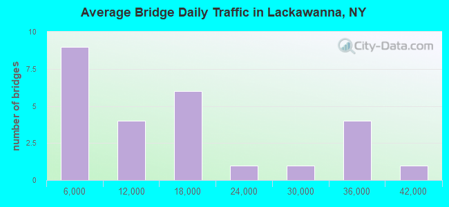
- 351,582Total average daily traffic
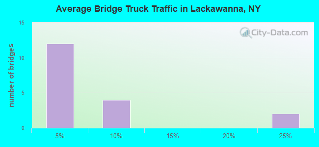
- 19,224Total average daily truck traffic
- National Bridge Inventory (NBI) Registered Bridges for Lackawanna
- No street view available for this location
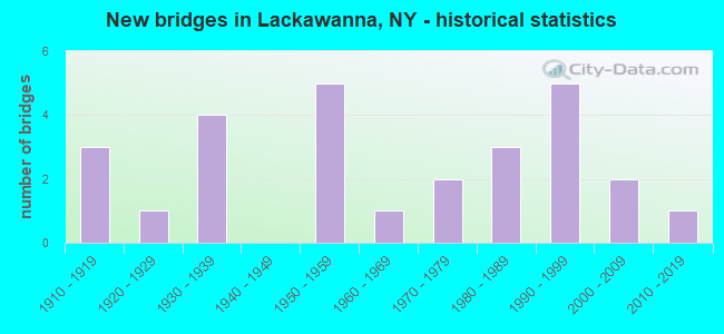
- New bridges - historical statistics
- 31910-1919
- 11920-1929
- 41930-1939
- 51950-1959
- 11960-1969
- 21970-1979
- 31980-1989
- 51990-1999
- 22000-2009
- 12010-2019
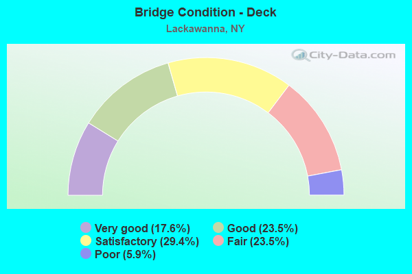
- Bridge Condition - Deck
- 17.6%Very good
- 23.5%Good
- 29.4%Satisfactory
- 23.5%Fair
- 5.9%Poor
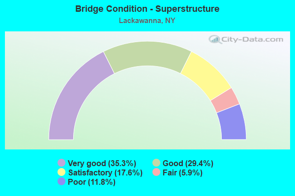
- Bridge Condition - Superstructure
- 35.3%Very good
- 29.4%Good
- 17.6%Satisfactory
- 5.9%Fair
- 11.8%Poor
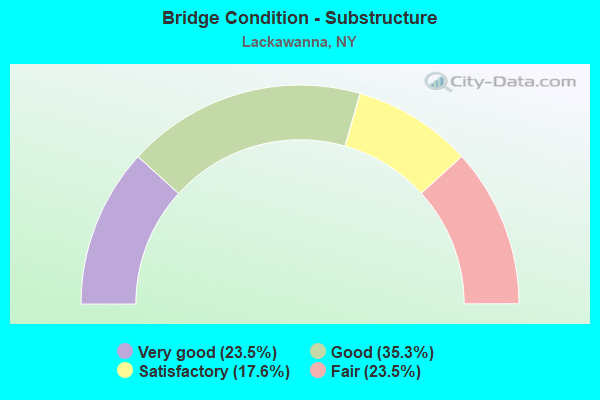
- Bridge Condition - Substructure
- 23.5%Very good
- 35.3%Good
- 17.6%Satisfactory
- 23.5%Fair
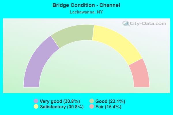
- Bridge Condition - Channel
- 30.8%Very good
- 23.1%Good
- 30.8%Satisfactory
- 15.4%Fair
Find on map >> Show street view
Structure Number: 100149, Location: 1.6 MI N JCT RTS 5 + 179 (Lat: 42.812833, Lng: -78.845453), Route carried "on" structure: State highway 5, Year Built: 2001, Status: Open, Structure Length: 2.87m (9.42ft), Average Daily Traffic: 30,436 (year 2019), Truck Traffic: 7%, Average Future Daily Traffic: 30,579 (year 2040), Design Load: HS 25 or greater, Features Intersected: SMOKES CREEK
Minimum Vertical Clearance: 30+ m (98+ ft), Kilometerpoint: 36.492, Lanes on structure: 5, Base Highway Network: Yes, Owner: State Highway Agency, Approaching Roadway Width: 24.7m (81.0ft), Skew: 2 degrees, Material/Design: Steel, Design/Construction: Stringer/Multi-beam, Number Of Spans In Main Unit: 1, Length of Maximum Span: 28.0m (91.9ft), Curb or Sidewalk Widths: Left: 0.0m, Right: 1.5m (4.9ft), Curb-To-Curb Width: 24.6m (80.7ft), Out-to-Out Width: 26.9m (88.3ft)
Condition: Deck: Satisfactory, Superstructure: Very good, Substructure: Very good, Channel: Very good, Operating Rating: 89.8 metric tons, Method Used To Determine Operating Rating: Load Factor (LF), Inventory Rating: 53.5 metric tons, Method Used To Determine Inventory Rating: Load Factor (LF), Structural Evaluation: Equal to present desirable criteria, Deck Geometry: Superior to present desirable criteria, Waterway Adequacy: Equal to present minimum criteria, Approach Roadway Alignment: Equal to present desirable criteria, Length Of Structure Improvement: 2.86m (9.38ft), Designated Inspection Frequency: Every 24 months, Inspection Date: September 2021, Bridge Improvement Cost: $3,132,000, Roadway Improvement Cost: $1,834,000, Total Project Cost: $4,967,000 ( Estimate for 2021), Deck Structure Type: Concrete Cast-file-Place, Wearing Surface/Protective System: Wearing Surface: Monolithic Concrete, Deck Protection: Epoxy Coated Reinforcing
Find on map >> Show street view
Structure Number: 107426, Location: 2.6 MI N JCT SH 5 & SH179 (Lat: 42.827781, Lng: -78.850767), Route carried "on" structure: State highway 5, Year Built: 1991, Status: Open, Structure Length: 3.11m (10.20ft), Average Daily Traffic: 21,487 (year 2019), Truck Traffic: 5%, Average Future Daily Traffic: 24,899 (year 2040), Design Load: HS 20, Features Intersected: RIDGE ROAD
Minimum Vertical Clearance: 30+ m (98+ ft), Kilometerpoint: 38.214, Lanes on structure: 4, Lanes under structure: 3, Base Highway Network: Yes, Owner: State Highway Agency, Approaching Roadway Width: 24.4m (80.1ft), Skew: 21 degrees, Material/Design: Prestressed concrete, Design/Construction: Box Beam or Girders - Multiple, Number Of Spans In Main Unit: 1, Length of Maximum Span: 30.4m (99.7ft), Curb-To-Curb Width: 24.0m (78.7ft), Out-to-Out Width: 25.8m (84.6ft)
Condition: Deck: Satisfactory, Superstructure: Satisfactory, Substructure: Good, Operating Rating: 89.8 metric tons, Method Used To Determine Operating Rating: Load Factor (LF), Inventory Rating: 69.9 metric tons, Method Used To Determine Inventory Rating: Load Factor (LF), Structural Evaluation: Equal to present minimum criteria, Deck Geometry: Superior to present desirable criteria, Underclear: Meets minimum limits, Approach Roadway Alignment: Equal to present desirable criteria, Length Of Structure Improvement: 3.10m (10.17ft), Designated Inspection Frequency: Every 24 months, Inspection Date: July 2021, Bridge Improvement Cost: $2,618,000, Roadway Improvement Cost: $1,533,000, Total Project Cost: $4,151,000 ( Estimate for 2021), Wearing Surface/Protective System: Wearing Surface: Integral Concrete
Find on map >> Show street view
Structure Number: 202828, Location: 1.6MI N JCT RTS 162 & 179 (Lat: 42.812489, Lng: -78.823944), Route carried "on" structure: US 62, Year Built: 1991, Status: Open, Structure Length: 2.01m (6.59ft), Average Daily Traffic: 10,118 (year 2018), Truck Traffic: 4%, Average Future Daily Traffic: 10,165 (year 2040), Design Load: HS 20, Features Intersected: S BR SMOKES CRK
Minimum Vertical Clearance: 30+ m (98+ ft), Kilometerpoint: 43.475, Lanes on structure: 2, Base Highway Network: Yes, Owner: City or Municipal Highway Agency, Approaching Roadway Width: 12.8m (42.0ft), Skew: 3 degrees, Material/Design: Prestressed concrete, Design/Construction: Box Beam or Girders - Multiple, Number Of Spans In Main Unit: 1, Length of Maximum Span: 18.5m (60.7ft), Curb or Sidewalk Widths: Left: 1.5m (4.9ft), Right: 1.5m (4.9ft), Curb-To-Curb Width: 12.8m (42.0ft), Out-to-Out Width: 16.5m (54.1ft)
Condition: Deck: Satisfactory, Superstructure: Good, Substructure: Good, Channel: Good, Operating Rating: 80.7 metric tons, Method Used To Determine Operating Rating: Load Factor (LF), Inventory Rating: 32.7 metric tons, Method Used To Determine Inventory Rating: Load Factor (LF), Structural Evaluation: Better than present minimum criteria, Deck Geometry: Somewhat better than minimum adequacy, Waterway Adequacy: Superior to present desirable criteria, Approach Roadway Alignment: Equal to present desirable criteria, Length Of Structure Improvement: 2.01m (6.59ft), Designated Inspection Frequency: Every 24 months, Inspection Date: May 2021, Bridge Improvement Cost: $1,405,000, Roadway Improvement Cost: $823,000, Total Project Cost: $2,228,000 ( Estimate for 2021), Deck Structure Type: Concrete Cast-file-Place, Wearing Surface/Protective System: Wearing Surface: Integral Concrete, Deck Protection: Epoxy Coated Reinforcing
Find on map >> Show street view
Structure Number: 202829, Location: .3 MI S JCT US62 & CR 137 (Lat: 42.819878, Lng: -78.824003), Route carried "on" structure: US 62, Year Built: 1991, Status: Open, Structure Length: 2.56m (8.40ft), Average Daily Traffic: 10,118 (year 2018), Truck Traffic: 4%, Average Future Daily Traffic: 10,165 (year 2040), Design Load: HS 20, Features Intersected: N BR SMOKES CREEK
Minimum Vertical Clearance: 30+ m (98+ ft), Kilometerpoint: 44.296, Lanes on structure: 2, Base Highway Network: Yes, Owner: City or Municipal Highway Agency, Approaching Roadway Width: 12.8m (42.0ft), Material/Design: Prestressed concrete, Design/Construction: Box Beam or Girders - Multiple, Number Of Spans In Main Unit: 1, Length of Maximum Span: 24.3m (79.7ft), Curb or Sidewalk Widths: Left: 1.5m (4.9ft), Right: 1.5m (4.9ft), Curb-To-Curb Width: 12.8m (42.0ft), Out-to-Out Width: 16.5m (54.1ft)
Condition: Deck: Satisfactory, Superstructure: Good, Substructure: Good, Channel: Good, Operating Rating: 88.0 metric tons, Method Used To Determine Operating Rating: Load Factor (LF), Inventory Rating: 32.7 metric tons, Method Used To Determine Inventory Rating: Load Factor (LF), Structural Evaluation: Better than present minimum criteria, Deck Geometry: Somewhat better than minimum adequacy, Waterway Adequacy: Superior to present desirable criteria, Approach Roadway Alignment: Equal to present desirable criteria, Length Of Structure Improvement: 2.56m (8.40ft), Designated Inspection Frequency: Every 24 months, Inspection Date: May 2021, Bridge Improvement Cost: $1,558,000, Roadway Improvement Cost: $912,000, Total Project Cost: $2,470,000 ( Estimate for 2021), Deck Structure Type: Concrete Cast-file-Place, Wearing Surface/Protective System: Wearing Surface: Integral Concrete, Deck Protection: Epoxy Coated Reinforcing
Find on map >> Show street view
Structure Number: 22553, Location: 1.5 MI N JCT 62'SMOKES CK (Lat: 42.828881, Lng: -78.820092), Route carried "on" structure: City street , Year Built: 1974, Status: Open, Structure Length: 1.25m (4.10ft), Average Daily Traffic: 3,534 (year 2020), Truck Traffic: 2%, Average Future Daily Traffic: 3,731 (year 2040), Features Intersected: BUFFALO & PITTSBG, Facility Carried by Structure: MCKINLEY PARKWAY
Minimum Vertical Clearance: 30+ m (98+ ft), Kilometerpoint: 0.338, Lanes on structure: 2, Owner: City or Municipal Highway Agency, Approaching Roadway Width: 15.2m (49.9ft), Material/Design: Steel, Design/Construction: Stringer/Multi-beam, Number Of Spans In Main Unit: 1, Length of Maximum Span: 11.2m (36.7ft), Curb or Sidewalk Widths: Left: 1.2m (3.9ft), Right: 1.2m (3.9ft), Curb-To-Curb Width: 15.3m (50.2ft), Out-to-Out Width: 18.4m (60.4ft)
Condition: Deck: Fair, Superstructure: Satisfactory, Substructure: Satisfactory, Operating Rating: 36.9 metric tons, Method Used To Determine Operating Rating: Load and Resistance Factor Rating (LRFR) rating reported by rating factor(RF) method using HL-93 loadings, Inventory Rating: 28.5 metric tons, Method Used To Determine Inventory Rating: Load and Resistance Factor Rating (LRFR) rating reported by rating factor(RF) method using HL-93 loadings, Structural Evaluation: Equal to present minimum criteria, Deck Geometry: Superior to present desirable criteria, Underclear: High priority of corrective action, Approach Roadway Alignment: Equal to present desirable criteria, Length Of Structure Improvement: 1.24m (4.07ft), Designated Inspection Frequency: Every 24 months, Inspection Date: December 2020, Bridge Improvement Cost: $2,417,000, Roadway Improvement Cost: $1,415,000, Total Project Cost: $3,833,000 ( Estimate for 2021), Deck Structure Type: Concrete Cast-file-Place, Wearing Surface/Protective System: Wearing Surface: Bituminous
Find on map >> Show street view
Structure Number: 2255729, Location: 2.4 MI W EXIT 55 OF I90 (Lat: 42.826508, Lng: -78.837728), Route carried "on" structure: City street , Year Built: 2010, Status: Open, Structure Length: 29.05m (95.31ft), Average Daily Traffic: 9,992 (year 2018), Truck Traffic: 5%, Average Future Daily Traffic: 10,038 (year 2040), Design Load: HS 20, Features Intersected: BUFFALO PITTSBURGH, CSX, Facility Carried by Structure: RIDGE ROAD
Minimum Vertical Clearance: 30+ m (98+ ft), Kilometerpoint: 1.046, Lanes on structure: 4, Owner: City or Municipal Highway Agency, Approaching Roadway Width: 16.5m (54.1ft), Skew: 1 degrees, Material/Design: Steel continuous, Design/Construction: Stringer/Multi-beam, Number Of Spans In Main Unit: 6, Length of Maximum Span: 61.9m (203.1ft), Curb or Sidewalk Widths: Left: 1.7m (5.6ft), Right: 1.7m (5.6ft), Curb-To-Curb Width: 16.5m (54.1ft), Out-to-Out Width: 22.0m (72.2ft)
Condition: Deck: Very good, Superstructure: Very good, Substructure: Very good, Operating Rating: 65.3 metric tons, Method Used To Determine Operating Rating: Load Factor (LF), Inventory Rating: 39.0 metric tons, Method Used To Determine Inventory Rating: Load Factor (LF), Structural Evaluation: Equal to present desirable criteria, Deck Geometry: Meets minimum limits, Underclear: Meets minimum limits, Approach Roadway Alignment: Equal to present desirable criteria, Length Of Structure Improvement: 29.04m (95.28ft), Designated Inspection Frequency: Every 24 months, Inspection Date: December 2020, Bridge Improvement Cost: $22,936,000, Roadway Improvement Cost: $13,432,000, Total Project Cost: $36,368,000 ( Estimate for 2021), Deck Structure Type: Concrete Cast-file-Place, Wearing Surface/Protective System: Wearing Surface: Integral Concrete, Deck Protection: Epoxy Coated Reinforcing
Find on map >> Show street view
Structure Number: 226027, Location: 0.4 MI E SE END SOUTHPARK (Lat: 42.827133, Lng: -78.817417), Route carried "on" structure: City street , Year Built: 1920, Year Reconstructed: 2015, Status: Open, Structure Length: 1.28m (4.20ft), Average Daily Traffic: 12,108 (year 2020), Truck Traffic: 7%, Average Future Daily Traffic: 12,164 (year 2040), Design Load: HL 93, Features Intersected: BUFF & PITTSBURGH, Facility Carried by Structure: RIDGE ROAD
Minimum Vertical Clearance: 30+ m (98+ ft), Kilometerpoint: 2.848, Lanes on structure: 4, Owner: City or Municipal Highway Agency, Approaching Roadway Width: 13.7m (44.9ft), Skew: 2 degrees, Material/Design: Prestressed concrete, Design/Construction: Box Beam or Girders - Multiple, Number Of Spans In Main Unit: 1, Length of Maximum Span: 12.2m (40.0ft), Curb or Sidewalk Widths: Left: 1.5m (4.9ft), Right: 1.5m (4.9ft), Curb-To-Curb Width: 13.7m (44.9ft), Out-to-Out Width: 17.8m (58.4ft)
Condition: Deck: Good, Superstructure: Very good, Substructure: Good, Operating Rating: 65.1 metric tons, Method Used To Determine Operating Rating: Load and Resistance Factor Rating (LRFR) rating reported by rating factor(RF) method using HL-93 loadings, Inventory Rating: 50.2 metric tons, Method Used To Determine Inventory Rating: Load and Resistance Factor Rating (LRFR) rating reported by rating factor(RF) method using HL-93 loadings, Structural Evaluation: Better than present minimum criteria, Deck Geometry: High priority of replacement, Underclear: Meets minimum limits, Approach Roadway Alignment: Equal to present desirable criteria, Length Of Structure Improvement: 1.28m (4.20ft), Designated Inspection Frequency: Every 24 months, Inspection Date: December 2020, Bridge Improvement Cost: $1,693,000, Roadway Improvement Cost: $991,000, Total Project Cost: $2,685,000 ( Estimate for 2021), Deck Structure Type: Concrete Cast-file-Place, Wearing Surface/Protective System: Wearing Surface: Integral Concrete, Deck Protection: Galvanized Reinforcing
Find on map >> Show street view
Structure Number: 226033, Location: CENTER OF LACKAWANNA (Lat: 42.819228, Lng: -78.827936), Route carried "on" structure: City street , Year Built: 1930, Status: Open, Structure Length: 1.40m (4.59ft), Average Daily Traffic: 3,438 (year 2017), Truck Traffic: 2%, Average Future Daily Traffic: 4,813 (year 2037), Features Intersected: SMOKES CREEK, Facility Carried by Structure: ELECTRIC AVENUE
Minimum Vertical Clearance: 30+ m (98+ ft), Kilometerpoint: 1.561, Lanes on structure: 2, Owner: City or Municipal Highway Agency, Approaching Roadway Width: 12.2m (40.0ft), Material/Design: Steel, Design/Construction: Stringer/Multi-beam, Number Of Spans In Main Unit: 1, Length of Maximum Span: 12.8m (42.0ft), Curb or Sidewalk Widths: Left: 1.8m (5.9ft), Right: 1.9m (6.2ft), Curb-To-Curb Width: 12.1m (39.7ft), Out-to-Out Width: 16.6m (54.5ft)
Condition: Deck: Fair, Superstructure: Fair, Substructure: Fair, Channel: Satisfactory, Operating Rating: 43.7 metric tons, Method Used To Determine Operating Rating: Load and Resistance Factor Rating (LRFR) rating reported by rating factor(RF) method using HL-93 loadings, Inventory Rating: 33.7 metric tons, Method Used To Determine Inventory Rating: Load and Resistance Factor Rating (LRFR) rating reported by rating factor(RF) method using HL-93 loadings, Structural Evaluation: Somewhat better than minimum adequacy, Deck Geometry: Somewhat better than minimum adequacy, Waterway Adequacy: Better than present minimum criteria, Approach Roadway Alignment: Equal to present desirable criteria, Length Of Structure Improvement: 1.40m (4.59ft), Designated Inspection Frequency: Every 24 months, Inspection Date: May 2020, Bridge Improvement Cost: $1,266,000, Roadway Improvement Cost: $741,000, Total Project Cost: $2,007,000 ( Estimate for 2021), Deck Structure Type: Concrete Cast-file-Place, Wearing Surface/Protective System: Wearing Surface: Bituminous
Find on map >> Show street view
Structure Number: 226034, Location: CENTER OF LACKAWANNA (Lat: 42.816753, Lng: -78.830547), Route carried "on" structure: ServiceCity street , Year Built: 1988, Status: Open, Structure Length: 1.89m (6.20ft), Average Daily Traffic: 825 (year 2020), Truck Traffic: 2%, Average Future Daily Traffic: 1,155 (year 2040), Design Load: HS 20, Features Intersected: SMOKES CREEK, Facility Carried by Structure: KIRBY AVENUE
Minimum Vertical Clearance: 30+ m (98+ ft), Kilometerpoint: 0.515, Lanes on structure: 2, Owner: City or Municipal Highway Agency, Approaching Roadway Width: 9.1m (29.9ft), Skew: 3 degrees, Material/Design: Prestressed concrete, Design/Construction: Box Beam or Girders - Multiple, Number Of Spans In Main Unit: 1, Length of Maximum Span: 18.2m (59.7ft), Curb or Sidewalk Widths: Left: 2.0m (6.6ft), Right: 2.0m (6.6ft), Curb-To-Curb Width: 9.8m (32.2ft), Out-to-Out Width: 14.3m (46.9ft)
Condition: Deck: Good, Superstructure: Very good, Substructure: Good, Channel: Very good, Operating Rating: 56.2 metric tons, Method Used To Determine Operating Rating: Load Factor (LF), Inventory Rating: 33.6 metric tons, Method Used To Determine Inventory Rating: Load Factor (LF), Structural Evaluation: Better than present minimum criteria, Deck Geometry: Equal to present minimum criteria, Waterway Adequacy: Equal to present desirable criteria, Approach Roadway Alignment: Equal to present desirable criteria, Length Of Structure Improvement: 1.88m (6.17ft), Designated Inspection Frequency: Every 24 months, Inspection Date: April 2020, Bridge Improvement Cost: $1,208,000, Roadway Improvement Cost: $707,000, Total Project Cost: $1,915,000 ( Estimate for 2021), Wearing Surface/Protective System: Wearing Surface: Monolithic Concrete
Find on map >> Show street view
Structure Number: 226035, Location: CENTER OF LACKAWANNA (Lat: 42.814919, Lng: -78.832083), Route carried "on" structure: City street , Year Built: 1930, Status: Closed, Structure Length: 1.31m (4.30ft), Average Daily Traffic: 384 (year 2019), Truck Traffic: 4%, Average Future Daily Traffic: 538 (year 2039), Features Intersected: SMOKES CREEK, Facility Carried by Structure: WARSAW AVENUE
Minimum Vertical Clearance: 30+ m (98+ ft), Kilometerpoint: 0.660, Lanes on structure: 2, Owner: City or Municipal Highway Agency, Approaching Roadway Width: 12.2m (40.0ft), Material/Design: Steel, Design/Construction: Stringer/Multi-beam, Number Of Spans In Main Unit: 1, Length of Maximum Span: 12.5m (41.0ft), Curb or Sidewalk Widths: Left: 1.9m (6.2ft), Right: 1.9m (6.2ft), Curb-To-Curb Width: 12.2m (40.0ft), Out-to-Out Width: 16.5m (54.1ft)
Condition: Deck: Fair, Superstructure: Poor, Substructure: Fair, Channel: Satisfactory, Deck Geometry: Superior to present desirable criteria, Waterway Adequacy: Equal to present desirable criteria, Approach Roadway Alignment: Meets minimum limits, Bridge Posting: Required (Relationship of Operating Rating to Maximum Legal Load: > 39.9% below), Length Of Structure Improvement: 1.31m (4.30ft), Designated Inspection Frequency: Every 12 months, Inspection Date: December 2021, Bridge Improvement Cost: $1,727,000, Roadway Improvement Cost: $1,011,000, Total Project Cost: $2,738,000 ( Estimate for 2021), Deck Structure Type: Concrete Cast-file-Place, Wearing Surface/Protective System: Wearing Surface: Bituminous
Find on map >> Show street view
Structure Number: 226036, Location: CENTER OF LACKAWANNA (Lat: 42.813650, Lng: -78.831322), Route carried "on" structure: City street , Year Built: 1967, Status: Open, Structure Length: 1.89m (6.20ft), Average Daily Traffic: 236 (year 2017), Truck Traffic: 1%, Average Future Daily Traffic: 330 (year 2037), Features Intersected: SMOKES CREEK, Facility Carried by Structure: WOOD STREET
Minimum Vertical Clearance: 30+ m (98+ ft), Kilometerpoint: 0.225, Lanes on structure: 2, Owner: City or Municipal Highway Agency, Approaching Roadway Width: 9.1m (29.9ft), Skew: 2 degrees, Material/Design: Steel, Design/Construction: Stringer/Multi-beam, Number Of Spans In Main Unit: 1, Length of Maximum Span: 18.2m (59.7ft), Curb or Sidewalk Widths: Left: 1.2m (3.9ft), Right: 1.2m (3.9ft), Curb-To-Curb Width: 9.1m (29.9ft), Out-to-Out Width: 12.0m (39.4ft)
Condition: Deck: Satisfactory, Superstructure: Good, Substructure: Fair, Channel: Fair, Operating Rating: 90.7 metric tons, Method Used To Determine Operating Rating: Load Factor (LF), Inventory Rating: 53.5 metric tons, Method Used To Determine Inventory Rating: Load Factor (LF), Structural Evaluation: Somewhat better than minimum adequacy, Deck Geometry: Equal to present minimum criteria, Waterway Adequacy: Meets minimum limits, Approach Roadway Alignment: Equal to present desirable criteria, Length Of Structure Improvement: 1.88m (6.17ft), Designated Inspection Frequency: Every 24 months, Inspection Date: August 2020, Bridge Improvement Cost: $1,812,000, Roadway Improvement Cost: $1,061,000, Total Project Cost: $2,873,000 ( Estimate for 2021), Deck Structure Type: Concrete Cast-file-Place, Wearing Surface/Protective System: Wearing Surface: Bituminous
Find on map >> Show street view
Structure Number: 226037, Location: 0.2 MI W RTE 62'SMOKES CK (Lat: 42.812367, Lng: -78.828306), Route carried "on" structure: City street , Year Built: 1930, Status: Open, Structure Length: 1.77m (5.81ft), Average Daily Traffic: 2,637 (year 2017), Truck Traffic: 3%, Average Future Daily Traffic: 3,692 (year 2037), Features Intersected: S BR SMOKES CRK., Facility Carried by Structure: ELECTRIC AVENUE
Minimum Vertical Clearance: 30+ m (98+ ft), Kilometerpoint: 0.805, Lanes on structure: 2, Owner: City or Municipal Highway Agency, Approaching Roadway Width: 9.8m (32.2ft), Skew: 3 degrees, Material/Design: Steel, Design/Construction: Stringer/Multi-beam, Number Of Spans In Main Unit: 1, Length of Maximum Span: 16.4m (53.8ft), Curb or Sidewalk Widths: Left: 1.8m (5.9ft), Right: 1.8m (5.9ft), Curb-To-Curb Width: 12.2m (40.0ft), Out-to-Out Width: 16.5m (54.1ft)
Condition: Deck: Poor, Superstructure: Poor, Substructure: Fair, Channel: Satisfactory, Operating Rating: 86.2 metric tons, Method Used To Determine Operating Rating: Load Factor (LF), Inventory Rating: 51.7 metric tons, Method Used To Determine Inventory Rating: Load Factor (LF), Structural Evaluation: Meets minimum limits, Deck Geometry: Equal to present minimum criteria, Waterway Adequacy: Better than present minimum criteria, Approach Roadway Alignment: Equal to present desirable criteria, Length Of Structure Improvement: 1.76m (5.77ft), Designated Inspection Frequency: Every 24 months, Critical Feature Inspection Frequency: Every 12 months, Inspection Date: May 2021, Critical Feature Inspection Date: May 2021, Bridge Improvement Cost: $1,980,000, Roadway Improvement Cost: $1,159,000, Total Project Cost: $3,139,000 ( Estimate for 2021), Deck Structure Type: Concrete Cast-file-Place, Wearing Surface/Protective System: Wearing Surface: Bituminous
Find on map >> Show street view
Structure Number: 226039, Location: NE QUAD OF LACKAWANNA (Lat: 42.820544, Lng: -78.810125), Route carried "on" structure: City street , Year Built: 2006, Status: Open, Structure Length: 2.19m (7.19ft), Average Daily Traffic: 2,583 (year 2017), Truck Traffic: 1%, Average Future Daily Traffic: 3,616 (year 2037), Design Load: HS 25 or greater, Features Intersected: N BR SMOKES CREEK, Facility Carried by Structure: SOUTH SHORE BLVD.
Minimum Vertical Clearance: 30+ m (98+ ft), Kilometerpoint: 1.271, Lanes on structure: 2, Owner: City or Municipal Highway Agency, Approaching Roadway Width: 12.2m (40.0ft), Skew: 1 degrees, Material/Design: Prestressed concrete, Design/Construction: Box Beam or Girders - Multiple, Number Of Spans In Main Unit: 1, Length of Maximum Span: 21.0m (68.9ft), Curb or Sidewalk Widths: Left: 1.8m (5.9ft), Right: 1.8m (5.9ft), Curb-To-Curb Width: 12.2m (40.0ft), Out-to-Out Width: 16.4m (53.8ft)
Condition: Deck: Very good, Superstructure: Very good, Substructure: Very good, Channel: Very good, Operating Rating: 98.0 metric tons, Method Used To Determine Operating Rating: Load Factor (LF), Inventory Rating: 49.9 metric tons, Method Used To Determine Inventory Rating: Load Factor (LF), Structural Evaluation: Equal to present desirable criteria, Deck Geometry: Equal to present minimum criteria, Waterway Adequacy: Equal to present desirable criteria, Approach Roadway Alignment: Equal to present desirable criteria, Length Of Structure Improvement: 2.19m (7.19ft), Designated Inspection Frequency: Every 24 months, Inspection Date: April 2020, Bridge Improvement Cost: $1,024,000, Roadway Improvement Cost: $599,000, Total Project Cost: $1,623,000 ( Estimate for 2021), Deck Structure Type: Concrete Cast-file-Place, Wearing Surface/Protective System: Wearing Surface: Monolithic Concrete, Deck Protection: Galvanized Reinforcing
Find on map >> Show street view
Structure Number: 332742, Location: .2 MI S JCT CR 4 & CR 137 (Lat: 42.822531, Lng: -78.802469), Route carried "on" structure: County highway , Year Built: 1990, Status: Open, Structure Length: 2.19m (7.19ft), Average Daily Traffic: 12,091 (year 2020), Truck Traffic: 2%, Average Future Daily Traffic: 12,768 (year 2040), Design Load: HS 20+Mod, Features Intersected: SMOKES CREEK, Facility Carried by Structure: ABBOTT ROAD
Minimum Vertical Clearance: 30+ m (98+ ft), Kilometerpoint: 9.300, Lanes on structure: 4, Owner: County Highway Agency, Approaching Roadway Width: 13.4m (44.0ft), Skew: 1 degrees, Material/Design: Steel, Design/Construction: Stringer/Multi-beam, Number Of Spans In Main Unit: 1, Length of Maximum Span: 21.3m (69.9ft), Curb or Sidewalk Widths: Left: 1.8m (5.9ft), Right: 1.1m (3.6ft), Curb-To-Curb Width: 14.0m (45.9ft), Out-to-Out Width: 17.7m (58.1ft)
Condition: Deck: Good, Superstructure: Good, Substructure: Good, Channel: Satisfactory, Operating Rating: 87.5 metric tons, Method Used To Determine Operating Rating: Load and Resistance Factor Rating (LRFR) rating reported by rating factor(RF) method using HL-93 loadings, Inventory Rating: 67.4 metric tons, Method Used To Determine Inventory Rating: Load and Resistance Factor Rating (LRFR) rating reported by rating factor(RF) method using HL-93 loadings, Structural Evaluation: Better than present minimum criteria, Deck Geometry: High priority of replacement, Waterway Adequacy: Equal to present minimum criteria, Approach Roadway Alignment: Equal to present desirable criteria, Length Of Structure Improvement: 2.19m (7.19ft), Designated Inspection Frequency: Every 24 months, Inspection Date: April 2021, Bridge Improvement Cost: $2,234,000, Roadway Improvement Cost: $1,308,000, Total Project Cost: $3,542,000 ( Estimate for 2021), Deck Structure Type: Concrete Cast-file-Place, Wearing Surface/Protective System: Wearing Surface: Integral Concrete, Deck Protection: Epoxy Coated Reinforcing
Find on map >> Show street view
Structure Number: 3327539, Location: .1 MI S JCT I90&SMOKES CK (Lat: 42.804636, Lng: -78.809794), Route carried "on" structure: County highway , Year Built: 1981, Status: Open, Structure Length: 1.65m (5.41ft), Average Daily Traffic: 4,593 (year 2017), Truck Traffic: 2%, Average Future Daily Traffic: 4,850 (year 2040), Design Load: HS 20, Features Intersected: S BR SMOKES CREEK, Facility Carried by Structure: WILLET ROAD
Minimum Vertical Clearance: 30+ m (98+ ft), Kilometerpoint: 0.016, Lanes on structure: 2, Owner: County Highway Agency, Approaching Roadway Width: 11.6m (38.1ft), Skew: 22 degrees, Material/Design: Steel, Design/Construction: Stringer/Multi-beam, Number Of Spans In Main Unit: 1, Length of Maximum Span: 15.5m (50.9ft), Curb or Sidewalk Widths: Left: 1.4m (4.6ft), Right: 1.4m (4.6ft), Curb-To-Curb Width: 11.6m (38.1ft), Out-to-Out Width: 15.5m (50.9ft)
Condition: Deck: Fair, Superstructure: Good, Substructure: Satisfactory, Channel: Good, Operating Rating: 90.4 metric tons, Method Used To Determine Operating Rating: Load and Resistance Factor Rating (LRFR) rating reported by rating factor(RF) method using HL-93 loadings, Inventory Rating: 69.7 metric tons, Method Used To Determine Inventory Rating: Load and Resistance Factor Rating (LRFR) rating reported by rating factor(RF) method using HL-93 loadings, Structural Evaluation: Equal to present minimum criteria, Deck Geometry: Somewhat better than minimum adequacy, Waterway Adequacy: Somewhat better than minimum adequacy, Approach Roadway Alignment: Equal to present desirable criteria, Length Of Structure Improvement: 1.64m (5.38ft), Designated Inspection Frequency: Every 24 months, Inspection Date: July 2020, Bridge Improvement Cost: $1,603,000, Roadway Improvement Cost: $939,000, Total Project Cost: $2,542,000 ( Estimate for 2021), Deck Structure Type: Concrete Cast-file-Place, Wearing Surface/Protective System: Wearing Surface: Integral Concrete, Deck Protection: Epoxy Coated Reinforcing
Find on map >> Show street view
Structure Number: 332755, Location: 1 MILE EAST OF BLASDELL (Lat: 42.796814, Lng: -78.803936), Route carried "on" structure: County highway , Year Built: 1972, Status: Open, Structure Length: 1.40m (4.59ft), Average Daily Traffic: 6,880 (year 2017), Truck Traffic: 4%, Average Future Daily Traffic: 7,265 (year 2040), Features Intersected: S BR SMOKES CREEK, Facility Carried by Structure: LAKE AVENUE
Minimum Vertical Clearance: 30+ m (98+ ft), Kilometerpoint: 3.524, Lanes on structure: 4, Owner: County Highway Agency, Approaching Roadway Width: 15.8m (51.8ft), Material/Design: Steel, Design/Construction: Stringer/Multi-beam, Number Of Spans In Main Unit: 1, Length of Maximum Span: 12.8m (42.0ft), Curb or Sidewalk Widths: Left: 1.2m (3.9ft), Right: 1.2m (3.9ft), Curb-To-Curb Width: 15.8m (51.8ft), Out-to-Out Width: 18.9m (62.0ft)
Condition: Deck: Very good, Superstructure: Very good, Substructure: Very good, Channel: Very good, Operating Rating: 39.5 metric tons, Method Used To Determine Operating Rating: Load and Resistance Factor Rating (LRFR) rating reported by rating factor(RF) method using HL-93 loadings, Inventory Rating: 30.5 metric tons, Method Used To Determine Inventory Rating: Load and Resistance Factor Rating (LRFR) rating reported by rating factor(RF) method using HL-93 loadings, Structural Evaluation: Better than present minimum criteria, Deck Geometry: Meets minimum limits, Waterway Adequacy: Equal to present desirable criteria, Approach Roadway Alignment: Equal to present desirable criteria, Length Of Structure Improvement: 1.40m (4.59ft), Designated Inspection Frequency: Every 24 months, Inspection Date: April 2020, Bridge Improvement Cost: $1,816,000, Roadway Improvement Cost: $1,063,000, Total Project Cost: $2,879,000 ( Estimate for 2021), Deck Structure Type: Concrete Cast-file-Place, Wearing Surface/Protective System: Wearing Surface: Bituminous
Find on map >> Show street view
Structure Number: 551175, Location: 1.1 MI SE EXIT 55 ON I-90 (Lat: 42.805803, Lng: -78.810256), Route carried "on" structure: Interstate 90, Year Built: 1956, Status: Open, Structure Length: 2.16m (7.09ft), Average Daily Traffic: 30,919 (year 2017), Truck Traffic: 21%, Average Future Daily Traffic: 34,650 (year 2040), Design Load: HS 20+Mod, Features Intersected: S BR SMOKE CREEK
Minimum Vertical Clearance: 30+ m (98+ ft), Kilometerpoint: 36.959, Lanes on structure: 4, Base Highway Network: Yes, Toll: On Interstate toll segment, Owner: State Toll Authority, Approaching Roadway Width: 24.4m (80.1ft), Skew: 34 degrees, Material/Design: Concrete, Design/Construction: Culvert, Number Of Spans In Main Unit: 3, Length of Maximum Span: 6.4m (21.0ft)
Condition: Channel: Fair, Culverts: Satisfactory, Structural Evaluation: Equal to present minimum criteria, Waterway Adequacy: Superior to present desirable criteria, Approach Roadway Alignment: Equal to present desirable criteria, Length Of Structure Improvement: 2.16m (7.09ft), Designated Inspection Frequency: Every 24 months, Inspection Date: May 2021, Bridge Improvement Cost: $2,509,000, Roadway Improvement Cost: $1,469,000, Total Project Cost: $3,978,000 ( Estimate for 2021)
Find on map >> Show street view
Structure Number: 5512149, Location: 1.0 MI SW JCT I90(Lat: 42.810953, Lng: -78.799189), Route carried "on" structure: Interstate 90, Year Built: 1956, Status: Open, Structure Length: 5.18m (16.99ft), Average Daily Traffic: 30,919 (year 2017), Truck Traffic: 21%, Average Future Daily Traffic: 34,650 (year 2040), Design Load: HS 25 or greater, Features Intersected: ABBOTT RD
Minimum Vertical Clearance: 30+ m (98+ ft), Kilometerpoint: 38.021, Lanes on structure: 6, Lanes under structure: 5, Base Highway Network: Yes, Toll: On Interstate toll segment, Owner: State Toll Authority, Approaching Roadway Width: 32.9m (107.9ft), Skew: 21 degrees, Material/Design: Steel, Design/Construction: Stringer/Multi-beam, Number Of Spans In Main Unit: 3, Length of Maximum Span: 23.2m (76.1ft), Curb-To-Curb Width: 32.6m (107.0ft), Out-to-Out Width: 34.4m (112.9ft)
Condition: Deck: Good, Superstructure: Satisfactory, Substructure: Satisfactory, Operating Rating: 46.0 metric tons, Method Used To Determine Operating Rating: Load and Resistance Factor Rating (LRFR) rating reported by rating factor(RF) method using HL-93 loadings, Inventory Rating: 35.3 metric tons, Method Used To Determine Inventory Rating: Load and Resistance Factor Rating (LRFR) rating reported by rating factor(RF) method using HL-93 loadings, Structural Evaluation: Equal to present minimum criteria, Deck Geometry: Superior to present desirable criteria, Underclear: High priority of corrective action, Approach Roadway Alignment: Equal to present desirable criteria, Length Of Structure Improvement: 5.18m (16.99ft), Designated Inspection Frequency: Every 24 months, Inspection Date: November 2020, Bridge Improvement Cost: $6,593,000, Roadway Improvement Cost: $3,861,000, Total Project Cost: $10,455,000 ( Estimate for 2021), Deck Structure Type: Concrete Cast-file-Place, Wearing Surface/Protective System: Wearing Surface: Monolithic Concrete
Structure Number: 5512149, Location: 1.0 MI SW JCT I90
Minimum Vertical Clearance: 30+ m (98+ ft), Kilometerpoint: 38.021, Lanes on structure: 6, Lanes under structure: 5, Base Highway Network: Yes, Toll: On Interstate toll segment, Owner: State Toll Authority, Approaching Roadway Width: 32.9m (107.9ft), Skew: 21 degrees, Material/Design: Steel, Design/Construction: Stringer/Multi-beam, Number Of Spans In Main Unit: 3, Length of Maximum Span: 23.2m (76.1ft), Curb-To-Curb Width: 32.6m (107.0ft), Out-to-Out Width: 34.4m (112.9ft)
Condition: Deck: Good, Superstructure: Satisfactory, Substructure: Satisfactory, Operating Rating: 46.0 metric tons, Method Used To Determine Operating Rating: Load and Resistance Factor Rating (LRFR) rating reported by rating factor(RF) method using HL-93 loadings, Inventory Rating: 35.3 metric tons, Method Used To Determine Inventory Rating: Load and Resistance Factor Rating (LRFR) rating reported by rating factor(RF) method using HL-93 loadings, Structural Evaluation: Equal to present minimum criteria, Deck Geometry: Superior to present desirable criteria, Underclear: High priority of corrective action, Approach Roadway Alignment: Equal to present desirable criteria, Length Of Structure Improvement: 5.18m (16.99ft), Designated Inspection Frequency: Every 24 months, Inspection Date: November 2020, Bridge Improvement Cost: $6,593,000, Roadway Improvement Cost: $3,861,000, Total Project Cost: $10,455,000 ( Estimate for 2021), Deck Structure Type: Concrete Cast-file-Place, Wearing Surface/Protective System: Wearing Surface: Monolithic Concrete
Find on map >> Show street view
Structure Number: 107426, Location: 2.6 MI N JCT SH 5 & SH179 (Lat: 42.827781, Lng: -78.850767), Route carried "under" structure: City street , Year Built: 1991, Structure Length: 0. m, Average Daily Traffic: 1,000 (year 2021), Features Intersected: RIDGE ROAD, Facility Carried by Structure: RTE 5
Minimum Vertical Clearance: 4.57m (14.99ft), Kilometerpoint: 0.000, Lanes on structure: 4, Lanes under structure: 3, Material/Design: Prestressed concrete, Design/Construction: Box Beam or Girders - Multiple, Length of Maximum Span: 30.4m (99.7ft)
Find on map >> Show street view
Structure Number: 5512149, Location: 1.0 MI SW JCT I90(Lat: 42.810953, Lng: -78.799189), Route carried "under" structure: County highway , Year Built: 1956, Structure Length: 0. m, Average Daily Traffic: 17,300 (year 2021), Features Intersected: ABBOTT RD, Facility Carried by Structure: RTE I90
Minimum Vertical Clearance: 4.57m (14.99ft), Kilometerpoint: 0.000, Lanes on structure: 6, Lanes under structure: 5, Material/Design: Steel, Design/Construction: Stringer/Multi-beam, Length of Maximum Span: 23.2m (76.1ft)
Structure Number: 5512149, Location: 1.0 MI SW JCT I90
Minimum Vertical Clearance: 4.57m (14.99ft), Kilometerpoint: 0.000, Lanes on structure: 6, Lanes under structure: 5, Material/Design: Steel, Design/Construction: Stringer/Multi-beam, Length of Maximum Span: 23.2m (76.1ft)
Find on map >> Show street view
Structure Number: 7001461, Location: 1 MI N JCT SH 5 & SH 179 (Lat: 42.804133, Lng: -78.846256), Route carried "under" structure: State highway 5, Year Built: 1930, Structure Length: 0. m, Average Daily Traffic: 35,895 (year 1998), Features Intersected: RTE 5, Facility Carried by Structure: SOUTH BUFFALO RR
Minimum Vertical Clearance: 4.41m (14.47ft), Kilometerpoint: 32.325, Lanes under structure: 5, Material/Design: Steel, Design/Construction: Girder and Floorbeam System, Length of Maximum Span: 20.7m (67.9ft)
Find on map >> Show street view
Structure Number: 7001462, Location: 1 MI N JCT SH 5 & SH 179 (Lat: 42.804078, Lng: -78.846261), Route carried "under" structure: State highway 5, Year Built: 1916, Structure Length: 0. m, Average Daily Traffic: 39,669 (year 1998), Features Intersected: RTE 5, Facility Carried by Structure: SOUTH BUFFALO RR
Minimum Vertical Clearance: 4.41m (14.47ft), Kilometerpoint: 35.543, Lanes under structure: 5, Material/Design: Steel, Design/Construction: Girder and Floorbeam System, Length of Maximum Span: 23.1m (75.8ft)
Find on map >> Show street view
Structure Number: 70283, Location: 2.9 MI N JCT RTS 62 & 179 (Lat: 42.831300, Lng: -78.823908), Route carried "under" structure: Alternate US 62, Year Built: 1915, Structure Length: 0. m, Average Daily Traffic: 12,200 (year 1979), Features Intersected: RTE 62, 62 X, Facility Carried by Structure: BUFF & PITTSBURGH
Minimum Vertical Clearance: 4.22m (13.85ft), Kilometerpoint: 2.961, Lanes under structure: 4, Material/Design: Steel, Design/Construction: Girder and Floorbeam System, Length of Maximum Span: 28.3m (92.8ft)
Find on map >> Show street view
Structure Number: 70283, Location: 2.9 MI N JCT RTS 62 & 179 (Lat: 42.831300, Lng: -78.823908), Route carried "under" structure: City street , Year Built: 1915, Structure Length: 0. m, Average Daily Traffic: 12,200 (year 1979), Features Intersected: RTE 62, 62 X, Facility Carried by Structure: BUFF & PITTSBURGH
Minimum Vertical Clearance: 4.19m (13.75ft), Kilometerpoint: 2.961, Lanes under structure: 4, Material/Design: Steel, Design/Construction: Girder and Floorbeam System, Length of Maximum Span: 28.3m (92.8ft)
Find on map >> Show street view
Structure Number: 770768, Location: 0.5 MI W JCT RTS 219 &I90 (Lat: 42.813831, Lng: -78.800050), Route carried "under" structure: County highway , Year Built: 1981, Structure Length: 0. m, Average Daily Traffic: 14,820 (year 1980), Features Intersected: ABBOTT ROAD,CR52A, Facility Carried by Structure: NORFOLK SOUTHERN
Minimum Vertical Clearance: 4.47m (14.67ft), Kilometerpoint: 1.078, Lanes under structure: 4, Material/Design: Steel, Design/Construction: Girder and Floorbeam System, Length of Maximum Span: 32.0m (105.0ft)
Find on map >> Show street view
Structure Number: 771457, Location: 2 MI SW JCT I190 & US 219 (Lat: 42.808067, Lng: -78.805808), Route carried "under" structure: Interstate 90, Year Built: 1956, Structure Length: 0. m, Average Daily Traffic: 25,200 (year 1977), Features Intersected: 90IX EB, RTE I90, Facility Carried by Structure: BUFFALO & PITTSBUR
Minimum Vertical Clearance: 4.42m (14.50ft), Kilometerpoint: 693.833, Lanes under structure: 2, Toll: On Interstate toll segment, Material/Design: Steel continuous, Design/Construction: Stringer/Multi-beam, Length of Maximum Span: 18.3m (60.0ft)
Find on map >> Show street view
Structure Number: 771457, Location: 2 MI SW JCT I190 & US 219 (Lat: 42.808067, Lng: -78.805808), Route carried "under" structure: Interstate , Year Built: 1956, Structure Length: 0. m, Features Intersected: 90IX EB, RTE I90, Facility Carried by Structure: BUFFALO & PITTSBUR
Minimum Vertical Clearance: 4.42m (14.50ft), Kilometerpoint: 693.833, Lanes under structure: 2, Toll: On Interstate toll segment, Material/Design: Steel continuous, Design/Construction: Stringer/Multi-beam, Length of Maximum Span: 18.3m (60.0ft)