Bridge Statistics for La Veta, Colorado (CO)
Condition, Traffic, Stress, Structural Evaluation, Project Costs
- National Bridge Inventory (NBI) Statistics
- 10Number of bridges
- 39ft / 12.2mTotal length
- $1,210,000Total costs
- 10,226Total average daily traffic
- 911Total average daily truck traffic
- 12,806Total future (year 2038) average daily traffic
- National Bridge Inventory (NBI) Registered Bridges for La Veta
- No street view available for this location
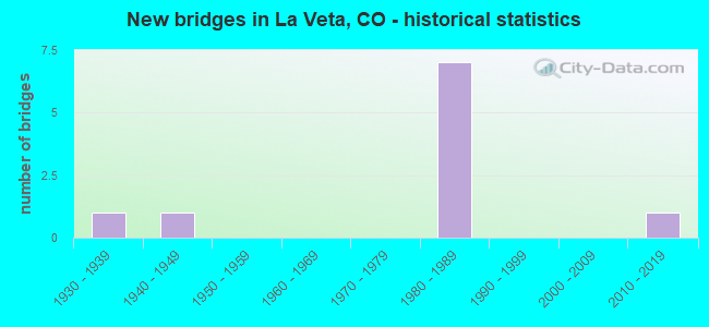
- New bridges - historical statistics
- 11930-1939
- 11940-1949
- 71980-1989
- 12010-2019


- Bridge Condition - Deck
- 14.3%Very good
- 14.3%Good
- 57.1%Satisfactory
- 14.3%Fair

- Bridge Condition - Superstructure
- 14.3%Very good
- 28.6%Good
- 42.9%Satisfactory
- 14.3%Fair

- Bridge Condition - Substructure
- 14.3%Very good
- 57.1%Good
- 14.3%Fair
- 14.3%Serious

- Bridge Condition - Channel
- 20.0%Very good
- 50.0%Good
- 10.0%Satisfactory
- 10.0%Fair
- 10.0%Poor

- Bridge Condition - Culverts
- 33.3%Very good
- 33.3%Good
- 33.3%Satisfactory
Find on map >> Show street view
Structure Number: HU350-S3.4-S16, Location: 2.3 MI NE OF LA VETA (Lat: 37.527544, Lng: -104.973792), Route carried "on" structure: County highway , Year Built: 1986, Status: Open, Structure Length: 0.76m (2.49ft), Average Daily Traffic: 103 (year 2018), Average Future Daily Traffic: 149 (year 2038), Features Intersected: WAHATOYA CREEK, Facility Carried by Structure: COUNTY ROAD 350
Minimum Vertical Clearance: 30+ m (98+ ft), Kilometerpoint: 3.166, Lanes on structure: 2, Owner: County Highway Agency, Approaching Roadway Width: 6.4m (21.0ft), Material/Design: Steel, Design/Construction: Stringer/Multi-beam, Number Of Spans In Main Unit: 1, Length of Maximum Span: 6.1m (20.0ft), Curb-To-Curb Width: 6.4m (21.0ft), Out-to-Out Width: 6.8m (22.3ft)
Condition: Deck: Satisfactory, Superstructure: Good, Substructure: Fair, Channel: Fair, Structural Evaluation: Somewhat better than minimum adequacy, Deck Geometry: Meets minimum limits, Waterway Adequacy: Equal to present desirable criteria, Approach Roadway Alignment: Equal to present minimum criteria, Designated Inspection Frequency: Every 24 months, Inspection Date: January 2021, Deck Structure Type: Concrete Cast-file-Place, Wearing Surface/Protective System: Wearing Surface: Monolithic Concrete
Find on map >> Show street view
Structure Number: HU360-2.3-S12, Location: 0.6 MI W OF CR 362 (Lat: 37.481308, Lng: -104.991583), Route carried "on" structure: County highway , Year Built: 1986, Status: Open, Structure Length: 0.80m (2.62ft), Average Daily Traffic: 63 (year 2018), Average Future Daily Traffic: 91 (year 2038), Features Intersected: WAHATOYA CREEK, Facility Carried by Structure: COUNTY ROAD 360
Minimum Vertical Clearance: 30+ m (98+ ft), Kilometerpoint: 8.165, Lanes on structure: 2, Owner: County Highway Agency, Approaching Roadway Width: 5.5m (18.0ft), Material/Design: Steel, Design/Construction: Stringer/Multi-beam, Number Of Spans In Main Unit: 1, Length of Maximum Span: 6.2m (20.3ft), Curb-To-Curb Width: 6.0m (19.7ft), Out-to-Out Width: 6.7m (22.0ft)
Condition: Deck: Satisfactory, Superstructure: Satisfactory, Substructure: Serious, Channel: Poor, Structural Evaluation: High priority of corrective action, Deck Geometry: Meets minimum limits, Waterway Adequacy: Equal to present minimum criteria, Approach Roadway Alignment: Somewhat better than minimum adequacy, Length Of Structure Improvement: 1.46m (4.79ft), Designated Inspection Frequency: Every 12 months, Inspection Date: January 2022, Bridge Improvement Cost: $770,000, Roadway Improvement Cost: $77,000, Total Project Cost: $847,000 ( Estimate for 2020), Deck Structure Type: Concrete Cast-file-Place, Wearing Surface/Protective System: Wearing Surface: Gravel
Find on map >> Show street view
Structure Number: HU450-3.3-S160A, Location: 0.5 MI NW OF LA VETA (Lat: 37.513414, Lng: -105.016472), Route carried "on" structure: County highway , Year Built: 1988, Status: Open, Structure Length: 1.89m (6.20ft), Average Daily Traffic: 278 (year 2018), Truck Traffic: 2%, Average Future Daily Traffic: 401 (year 2038), Features Intersected: MIDDLE CREEK, Facility Carried by Structure: COUNTY ROAD 450
Minimum Vertical Clearance: 30+ m (98+ ft), Kilometerpoint: 5.374, Lanes on structure: 2, Owner: County Highway Agency, Approaching Roadway Width: 6.7m (22.0ft), Material/Design: Steel, Design/Construction: Stringer/Multi-beam, Number Of Spans In Main Unit: 1, Length of Maximum Span: 17.4m (57.1ft), Curb-To-Curb Width: 9.7m (31.8ft), Out-to-Out Width: 9.8m (32.2ft)
Condition: Deck: Fair, Superstructure: Fair, Substructure: Good, Channel: Good, Operating Rating: 52.5 metric tons, Method Used To Determine Operating Rating: Load Factor (LF), Inventory Rating: 31.5 metric tons, Method Used To Determine Inventory Rating: Load Factor (LF), Structural Evaluation: Somewhat better than minimum adequacy, Deck Geometry: Equal to present minimum criteria, Waterway Adequacy: Equal to present desirable criteria, Approach Roadway Alignment: Better than present minimum criteria, Designated Inspection Frequency: Every 24 months, Inspection Date: January 2021, Deck Structure Type: Corrugated Steel, Wearing Surface/Protective System: Wearing Surface: Bituminous
Find on map >> Show street view
Structure Number: LA VETA-1-A, Location: 200 FT W OF OAK ST (Lat: 37.509086, Lng: -105.012142), Route carried "on" structure: City street , Year Built: 2018, Status: Open, Structure Length: 1.67m (5.48ft), Average Daily Traffic: 843 (year 2018), Truck Traffic: 2%, Average Future Daily Traffic: 1,214 (year 2038), Design Load: HL 93, Features Intersected: CUCHARAS RIVER, Facility Carried by Structure: TOWN ST RYUS AVE.
Minimum Vertical Clearance: 30+ m (98+ ft), Kilometerpoint: 0.343, Lanes on structure: 2, Owner: Town or Township Highway Agency, Approaching Roadway Width: 9.8m (32.2ft), Material/Design: Concrete, Design/Construction: Arch - Deck, Number Of Spans In Main Unit: 1, Length of Maximum Span: 15.2m (49.9ft), Curb or Sidewalk Widths: Left: 0.0m, Right: 1.5m (4.9ft), Curb-To-Curb Width: 9.8m (32.2ft), Out-to-Out Width: 12.2m (40.0ft)
Condition: Deck: Very good, Superstructure: Very good, Substructure: Very good, Channel: Very good, Operating Rating: 36.3 metric tons, Method Used To Determine Operating Rating: Field evaluation and documented engineering judgment, Inventory Rating: 32.7 metric tons, Method Used To Determine Inventory Rating: Field evaluation and documented engineering judgment, Structural Evaluation: Equal to present desirable criteria, Deck Geometry: Equal to present minimum criteria, Waterway Adequacy: Equal to present desirable criteria, Approach Roadway Alignment: Better than present minimum criteria, Designated Inspection Frequency: Every 24 months, Inspection Date: January 2021, Deck Structure Type: Other, Wearing Surface/Protective System: Wearing Surface: Bituminous
Find on map >> Show street view
Structure Number: LA VETA-2-A, Location: 0.1 MI W OF OAK STREET (Lat: 37.508033, Lng: -105.012203), Route carried "on" structure: City street , Year Built: 1988, Status: Open, Structure Length: 1.16m (3.81ft), Average Daily Traffic: 187 (year 2018), Truck Traffic: 2%, Average Future Daily Traffic: 269 (year 2038), Design Load: HS 20+Mod, Features Intersected: CUCHARAS RIVER, Facility Carried by Structure: FRANCISCO ST.
Minimum Vertical Clearance: 30+ m (98+ ft), Kilometerpoint: 0.328, Lanes on structure: 2, Owner: Town or Township Highway Agency, Approaching Roadway Width: 5.5m (18.0ft), Skew: 2 degrees, Material/Design: Wood or Timber, Design/Construction: Slab, Number Of Spans In Main Unit: 1, Length of Maximum Span: 11.0m (36.1ft), Curb-To-Curb Width: 7.3m (24.0ft), Out-to-Out Width: 7.7m (25.3ft)
Condition: Deck: Satisfactory, Superstructure: Satisfactory, Substructure: Good, Channel: Good, Operating Rating: 48.2 metric tons, Method Used To Determine Operating Rating: Allowable Stress (AS), Inventory Rating: 32.9 metric tons, Method Used To Determine Inventory Rating: Allowable Stress (AS), Structural Evaluation: Equal to present minimum criteria, Deck Geometry: Somewhat better than minimum adequacy, Waterway Adequacy: Equal to present desirable criteria, Approach Roadway Alignment: Equal to present desirable criteria, Designated Inspection Frequency: Every 24 months, Inspection Date: January 2021, Deck Structure Type: Wood or Timber, Wearing Surface/Protective System: Wearing Surface: Bituminous
Find on map >> Show street view
Structure Number: LA VETA-3-A, Location: .1 MI W OF OAK STREET (Lat: 37.505839, Lng: -105.012861), Route carried "on" structure: City street , Year Built: 1988, Status: Open, Structure Length: 0.98m (3.22ft), Average Daily Traffic: 152 (year 2018), Average Future Daily Traffic: 219 (year 2038), Design Load: HS 20+Mod, Features Intersected: CUCHARAS RIVER, Facility Carried by Structure: WEST VIRGINIA ST
Minimum Vertical Clearance: 30+ m (98+ ft), Kilometerpoint: 0.148, Lanes on structure: 2, Owner: Town or Township Highway Agency, Approaching Roadway Width: 6.1m (20.0ft), Skew: 2 degrees, Material/Design: Wood or Timber, Design/Construction: Slab, Number Of Spans In Main Unit: 1, Length of Maximum Span: 9.1m (29.9ft), Curb-To-Curb Width: 7.3m (24.0ft), Out-to-Out Width: 7.7m (25.3ft)
Condition: Deck: Satisfactory, Superstructure: Satisfactory, Substructure: Good, Channel: Good, Operating Rating: 47.4 metric tons, Method Used To Determine Operating Rating: Allowable Stress (AS), Inventory Rating: 32.9 metric tons, Method Used To Determine Inventory Rating: Allowable Stress (AS), Structural Evaluation: Equal to present minimum criteria, Deck Geometry: Somewhat better than minimum adequacy, Waterway Adequacy: Equal to present desirable criteria, Approach Roadway Alignment: Equal to present desirable criteria, Designated Inspection Frequency: Every 24 months, Inspection Date: January 2021, Deck Structure Type: Wood or Timber, Wearing Surface/Protective System: Wearing Surface: Bituminous
Find on map >> Show street view
Structure Number: N-16-H, Location: 16 MI W OF WALSENBURG (Lat: 37.541064, Lng: -105.065967), Route carried "on" structure: US 160A, Year Built: 1935, Status: Open, Structure Length: 0.64m (2.10ft), Average Daily Traffic: 4,100 (year 2020), Truck Traffic: 16%, Average Future Daily Traffic: 4,961 (year 2040), Design Load: H 20, Features Intersected: DRAW, Facility Carried by Structure: US 160 ML
Minimum Vertical Clearance: 30+ m (98+ ft), Kilometerpoint: 461.845, Lanes on structure: 2, Base Highway Network: Yes, Owner: State Highway Agency, Approaching Roadway Width: 11.9m (39.0ft), Material/Design: Concrete, Design/Construction: Culvert, Number Of Spans In Main Unit: 2, Length of Maximum Span: 3.0m (9.8ft), Out-to-Out Width: 18.9m (62.0ft)
Condition: Channel: Good, Culverts: Satisfactory, Operating Rating: 36.3 metric tons, Method Used To Determine Operating Rating: Field evaluation and documented engineering judgment, Inventory Rating: 32.7 metric tons, Method Used To Determine Inventory Rating: Field evaluation and documented engineering judgment, Structural Evaluation: Equal to present minimum criteria, Waterway Adequacy: Equal to present desirable criteria, Approach Roadway Alignment: Equal to present desirable criteria, Designated Inspection Frequency: Every 24 months, Inspection Date: Febuary 2020
Find on map >> Show street view
Structure Number: N-16-O, Location: 4 MI S OF JCT US 160 (Lat: 37.517872, Lng: -105.008908), Route carried "on" structure: State highway 12A, Year Built: 1947, Status: Open, Structure Length: 2.54m (8.33ft), Average Daily Traffic: 1,300 (year 2020), Truck Traffic: 3%, Average Future Daily Traffic: 1,534 (year 2040), Design Load: H 20, Features Intersected: CUCHARAS RIVER, Facility Carried by Structure: SH 12 ML
Minimum Vertical Clearance: 30+ m (98+ ft), Kilometerpoint: 6.413, Lanes on structure: 2, Owner: State Highway Agency, Approaching Roadway Width: 9.1m (29.9ft), Skew: 3 degrees, Material/Design: Steel, Design/Construction: Stringer/Multi-beam, Number Of Spans In Main Unit: 2, Length of Maximum Span: 11.9m (39.0ft), Curb or Sidewalk Widths: Left: 0.6m (2.0ft), Right: 0.6m (2.0ft), Curb-To-Curb Width: 7.6m (24.9ft), Out-to-Out Width: 9.4m (30.8ft)
Condition: Deck: Good, Superstructure: Good, Substructure: Good, Channel: Satisfactory, Operating Rating: 33.3 metric tons, Method Used To Determine Operating Rating: Load Factor (LF), Inventory Rating: 20.0 metric tons, Method Used To Determine Inventory Rating: Load Factor (LF), Structural Evaluation: Somewhat better than minimum adequacy, Deck Geometry: Meets minimum limits, Waterway Adequacy: Equal to present desirable criteria, Approach Roadway Alignment: Equal to present desirable criteria, Designated Inspection Frequency: Every 24 months, Inspection Date: October 2020, Deck Structure Type: Concrete Cast-file-Place, Wearing Surface/Protective System: Wearing Surface: Bituminous
Find on map >> Show street view
Structure Number: O-16-G, Location: 4.2 MI SO OF LA VETA (Lat: 37.457983, Lng: -105.031783), Route carried "on" structure: State highway 12A, Year Built: 1982, Status: Open, Structure Length: 0.91m (2.99ft), Average Daily Traffic: 1,600 (year 2020), Truck Traffic: 6%, Average Future Daily Traffic: 1,984 (year 2040), Design Load: H 20, Features Intersected: CUCHARAS RIVER, Facility Carried by Structure: SH 12 ML
Minimum Vertical Clearance: 30+ m (98+ ft), Kilometerpoint: 14.183, Lanes on structure: 2, Owner: State Highway Agency, Approaching Roadway Width: 7.9m (25.9ft), Design/Construction: Culvert, Number Of Spans In Main Unit: 3, Length of Maximum Span: 2.0m (6.6ft), Out-to-Out Width: 15.5m (50.9ft)
Condition: Channel: Good, Culverts: Very good, Operating Rating: 81.0 metric tons, Method Used To Determine Operating Rating: Load and Resistance Factor Rating (LRFR) rating reported by rating factor(RF) method using HL-93 loadings, Inventory Rating: 61.6 metric tons, Method Used To Determine Inventory Rating: Load and Resistance Factor Rating (LRFR) rating reported by rating factor(RF) method using HL-93 loadings, Structural Evaluation: Equal to present desirable criteria, Waterway Adequacy: Equal to present desirable criteria, Approach Roadway Alignment: Equal to present desirable criteria, Length Of Structure Improvement: 1.58m (5.18ft), Designated Inspection Frequency: Every 24 months, Inspection Date: October 2020, Bridge Improvement Cost: $242,000, Roadway Improvement Cost: $24,000, Total Project Cost: $363,000
Find on map >> Show street view
Structure Number: O-16-H, Location: SW EDGE OF LA VETA (Lat: 37.499514, Lng: -105.016264), Route carried "on" structure: State highway 12A, Year Built: 1985, Status: Open, Structure Length: 0.83m (2.72ft), Average Daily Traffic: 1,600 (year 2020), Truck Traffic: 6%, Average Future Daily Traffic: 1,984 (year 2040), Design Load: HS 20, Features Intersected: CUCHARAS RIVER, Facility Carried by Structure: SH 12 ML
Minimum Vertical Clearance: 30+ m (98+ ft), Kilometerpoint: 9.022, Lanes on structure: 2, Owner: State Highway Agency, Approaching Roadway Width: 11.6m (38.1ft), Skew: 2 degrees, Material/Design: Concrete, Design/Construction: Culvert, Number Of Spans In Main Unit: 2, Length of Maximum Span: 4.0m (13.1ft), Out-to-Out Width: 17.4m (57.1ft)
Condition: Channel: Very good, Culverts: Good, Operating Rating: 36.3 metric tons, Method Used To Determine Operating Rating: Field evaluation and documented engineering judgment, Inventory Rating: 32.7 metric tons, Method Used To Determine Inventory Rating: Field evaluation and documented engineering judgment, Structural Evaluation: Better than present minimum criteria, Waterway Adequacy: Equal to present desirable criteria, Approach Roadway Alignment: Equal to present desirable criteria, Designated Inspection Frequency: Every 48 months, Inspection Date: September 2018