Bridge Statistics for La Verne, California (CA)
Condition, Traffic, Stress, Structural Evaluation, Project Costs
- National Bridge Inventory (NBI) Statistics
- 32Number of bridges
- 144ft / 44.3mTotal length
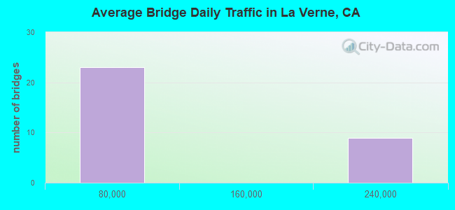
- 1,825,050Total average daily traffic
- 11,574Total average daily truck traffic
- National Bridge Inventory (NBI) Registered Bridges for La Verne
- No street view available for this location
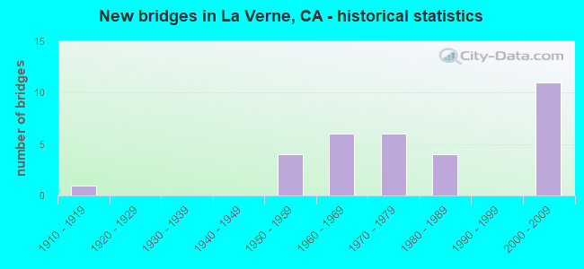
- New bridges - historical statistics
- 11910-1919
- 41950-1959
- 61960-1969
- 61970-1979
- 41980-1989
- 112000-2009
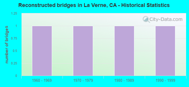
- Reconstructed bridges - Historical Statistics
- 11960-1969
- 11970-1979
- 11980-1989
- 11990-1999
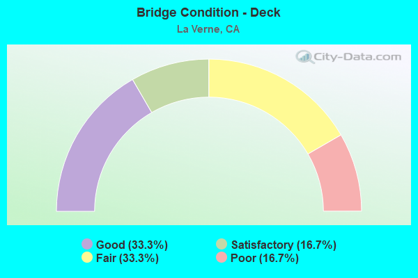
- Bridge Condition - Deck
- 33.3%Good
- 16.7%Satisfactory
- 33.3%Fair
- 16.7%Poor
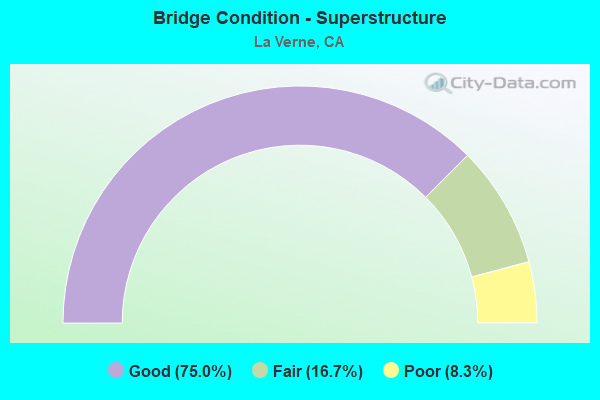
- Bridge Condition - Superstructure
- 75.0%Good
- 16.7%Fair
- 8.3%Poor
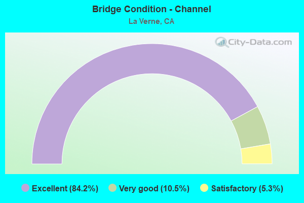
- Bridge Condition - Channel
- 84.2%Excellent
- 10.5%Very good
- 5.3%Satisfactory
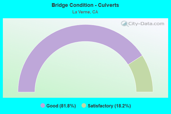
- Bridge Condition - Culverts
- 81.8%Good
- 18.2%Satisfactory
Find on map >> Show street view
Structure Number: 53 2075, Location: 07-LA-210-R46.61-LVN (Lat: 34.119875, Lng: -117.786992), Route carried "on" structure: Interstate 210, Year Built: 1970, Year Reconstructed: 1999, Status: Open, Structure Length: 4.91m (16.11ft), Average Daily Traffic: 179,000 (year 2015), Average Future Daily Traffic: 166,249 (year 2043), Design Load: HS 20, Features Intersected: STATE ROUTE 66
Minimum Vertical Clearance: 30+ m (98+ ft), Kilometerpoint: 46.610, Lanes on structure: 8, Lanes under structure: 4, Base Highway Network: Yes (Inventory Route: 2, Subroute: 1), Owner: State Highway Agency, Approaching Roadway Width: 52.6m (172.6ft), Skew: 24 degrees, Material/Design: Concrete continuous, Design/Construction: Box Beam or Girders - Multiple, Number Of Spans In Main Unit: 2, Length of Maximum Span: 24.4m (80.1ft), Curb-To-Curb Width: 52.6m (172.6ft), Out-to-Out Width: 54.1m (177.5ft)
Condition: Deck: Fair, Superstructure: Fair, Substructure: Good, Operating Rating: 54.1 metric tons, Method Used To Determine Operating Rating: Assigned rating based on Load Factor Design (LFD) reported in metric tons, Inventory Rating: 32.4 metric tons, Method Used To Determine Inventory Rating: Assigned rating based on Load Factor Design (LFD) reported in metric tons, Structural Evaluation: Somewhat better than minimum adequacy, Deck Geometry: Superior to present desirable criteria, Underclear: Meets minimum limits, Approach Roadway Alignment: Equal to present desirable criteria, Designated Inspection Frequency: Every 24 months, Inspection Date: Febuary 2021, Deck Structure Type: Concrete Cast-file-Place
Find on map >> Show street view
Structure Number: 53 2077, Location: 07-LA-210-R46.35-LVN (Lat: 34.119600, Lng: -117.791806), Route carried "on" structure: Interstate 210, Year Built: 1970, Status: Open, Structure Length: 0.73m (2.40ft), Average Daily Traffic: 31,500 (year 2015), Truck Traffic: 9%, Average Future Daily Traffic: 39,956 (year 2043), Design Load: HS 20, Features Intersected: PUDDINGSTONE CHANNEL
Minimum Vertical Clearance: 30+ m (98+ ft), Kilometerpoint: 46.350, Lanes on structure: 5, Base Highway Network: Yes (, Subroute: 1), Owner: State Highway Agency, Approaching Roadway Width: 23.1m (75.8ft), Skew: 30 degrees, Material/Design: Concrete, Design/Construction: Slab, Number Of Spans In Main Unit: 1, Length of Maximum Span: 6.4m (21.0ft), Curb-To-Curb Width: 44.8m (147.0ft), Out-to-Out Width: 61.0m (200.1ft)
Condition: Deck: Fair, Superstructure: Fair, Substructure: Good, Channel: Very good, Operating Rating: 54.1 metric tons, Method Used To Determine Operating Rating: Field evaluation and documented engineering judgment, Inventory Rating: 32.4 metric tons, Method Used To Determine Inventory Rating: Field evaluation and documented engineering judgment, Structural Evaluation: Somewhat better than minimum adequacy, Deck Geometry: Superior to present desirable criteria, Waterway Adequacy: Equal to present desirable criteria, Approach Roadway Alignment: Equal to present desirable criteria, Designated Inspection Frequency: Every 24 months, Inspection Date: Febuary 2021
Find on map >> Show street view
Structure Number: 53 2865, Location: 07-LA-210-R47.71-LVN (Lat: 34.120050, Lng: -117.768258), Route carried "on" structure: City street , Year Built: 2000, Status: Open, Structure Length: 8.18m (26.84ft), Average Daily Traffic: 800 (year 2015), Truck Traffic: 5%, Average Future Daily Traffic: 1,437 (year 2043), Design Load: HS 20+Mod, Features Intersected: INTERSTATE 210, Facility Carried by Structure: EMERALD AVE
Minimum Vertical Clearance: 30+ m (98+ ft), Kilometerpoint: 0.000, Lanes on structure: 2, Lanes under structure: 8, Owner: State Highway Agency, Approaching Roadway Width: 22.6m (74.1ft), Material/Design: Concrete continuous, Design/Construction: Box Beam or Girders - Multiple, Number Of Spans In Main Unit: 2, Length of Maximum Span: 43.0m (141.1ft), Curb or Sidewalk Widths: Left: 1.5m (4.9ft), Right: 1.5m (4.9ft), Curb-To-Curb Width: 19.6m (64.3ft), Out-to-Out Width: 23.2m (76.1ft)
Condition: Deck: Fair, Superstructure: Good, Substructure: Good, Operating Rating: 54.1 metric tons, Method Used To Determine Operating Rating: Assigned rating based on Load Factor Design (LFD) reported in metric tons, Inventory Rating: 32.4 metric tons, Method Used To Determine Inventory Rating: Assigned rating based on Load Factor Design (LFD) reported in metric tons, Structural Evaluation: Better than present minimum criteria, Deck Geometry: Superior to present desirable criteria, Underclear: Meets minimum limits, Approach Roadway Alignment: Equal to present desirable criteria, Designated Inspection Frequency: Every 24 months, Inspection Date: Febuary 2021, Deck Structure Type: Concrete Cast-file-Place
Find on map >> Show street view
Structure Number: 53 2867, Location: 07-LA-210-R48.08-LVN (Lat: 34.120000, Lng: -117.761769), Route carried "on" structure: City street L0680, Year Built: 2000, Status: Open, Structure Length: 7.35m (24.11ft), Average Daily Traffic: 1,500 (year 2012), Truck Traffic: 3%, Average Future Daily Traffic: 1,787 (year 2042), Design Load: HS 20+Mod, Features Intersected: INTERSTATE 210, Facility Carried by Structure: FRUIT STREET
Minimum Vertical Clearance: 30+ m (98+ ft), Kilometerpoint: 0.000, Lanes on structure: 4, Lanes under structure: 8, Owner: State Highway Agency, Approaching Roadway Width: 27.6m (90.6ft), Material/Design: Prestressed concrete continuous, Design/Construction: Box Beam or Girders - Single/Spread, Number Of Spans In Main Unit: 2, Length of Maximum Span: 37.3m (122.4ft), Curb or Sidewalk Widths: Left: 1.5m (4.9ft), Right: 1.5m (4.9ft), Curb-To-Curb Width: 27.6m (90.6ft), Out-to-Out Width: 31.2m (102.4ft)
Condition: Deck: Fair, Superstructure: Good, Substructure: Good, Operating Rating: 54.1 metric tons, Method Used To Determine Operating Rating: Assigned rating based on Load Factor Design (LFD) reported in metric tons, Inventory Rating: 32.4 metric tons, Method Used To Determine Inventory Rating: Assigned rating based on Load Factor Design (LFD) reported in metric tons, Structural Evaluation: Better than present minimum criteria, Deck Geometry: Superior to present desirable criteria, Underclear: Meets minimum limits, Approach Roadway Alignment: Equal to present desirable criteria, Designated Inspection Frequency: Every 24 months, Inspection Date: January 2021, Deck Structure Type: Concrete Cast-file-Place
Find on map >> Show street view
Structure Number: 53C0369, Location: 0.6MI W/O WHITE AVE (Lat: 34.098689, Lng: -117.775217), Route carried "on" structure: City street L528, Year Built: 1950, Year Reconstructed: 1969, Status: Open, Structure Length: 0.98m (3.22ft), Average Daily Traffic: 23,192 (year 2012), Truck Traffic: 5%, Average Future Daily Traffic: 27,830 (year 2041), Design Load: HS 20, Features Intersected: LIVE OAK WASH, Facility Carried by Structure: ARROW HWY
Minimum Vertical Clearance: 30+ m (98+ ft), Kilometerpoint: 0.000, Lanes on structure: 7, Owner: City or Municipal Highway Agency, Approaching Roadway Width: 24.1m (79.1ft), Material/Design: Concrete, Design/Construction: Frame, Number Of Spans In Main Unit: 1, Length of Maximum Span: 9.8m (32.2ft), Curb or Sidewalk Widths: Left: 2.5m (8.2ft), Right: 0.2m (0.7ft), Curb-To-Curb Width: 24.2m (79.4ft), Out-to-Out Width: 31.0m (101.7ft)
Condition: Deck: Good, Superstructure: Good, Substructure: Good, Channel: Excellent, Operating Rating: 56.7 metric tons, Method Used To Determine Operating Rating: Load Factor (LF), Inventory Rating: 34.0 metric tons, Method Used To Determine Inventory Rating: Load Factor (LF), Structural Evaluation: Better than present minimum criteria, Deck Geometry: High priority of replacement, Waterway Adequacy: Superior to present desirable criteria, Approach Roadway Alignment: Equal to present desirable criteria, Designated Inspection Frequency: Every 48 months, Inspection Date: October 2021, Deck Structure Type: Concrete Cast-file-Place, Wearing Surface/Protective System: Wearing Surface: Bituminous
Find on map >> Show street view
Structure Number: 53C0443, Location: 1.2MI W/O WHITE AVE (Lat: 34.100278, Lng: -117.782525), Route carried "on" structure: City street L528, Year Built: 1967, Status: Open, Structure Length: 0.79m (2.59ft), Average Daily Traffic: 22,880 (year 2012), Truck Traffic: 5%, Average Future Daily Traffic: 27,456 (year 2041), Features Intersected: MARSHALL CYN WASH, Facility Carried by Structure: ARROW HWY
Minimum Vertical Clearance: 30+ m (98+ ft), Kilometerpoint: 0.000, Lanes on structure: 6, Owner: City or Municipal Highway Agency, Approaching Roadway Width: 21.0m (68.9ft), Skew: 34 degrees, Material/Design: Concrete, Design/Construction: Culvert, Number Of Spans In Main Unit: 1, Length of Maximum Span: 5.5m (18.0ft), Curb or Sidewalk Widths: Left: 0.0m, Right: 1.6m (5.2ft)
Condition: Channel: Excellent, Culverts: Good, Operating Rating: 54.1 metric tons, Method Used To Determine Operating Rating: Field evaluation and documented engineering judgment, Inventory Rating: 32.4 metric tons, Method Used To Determine Inventory Rating: Field evaluation and documented engineering judgment, Structural Evaluation: Better than present minimum criteria, Waterway Adequacy: Superior to present desirable criteria, Approach Roadway Alignment: Equal to present desirable criteria, Designated Inspection Frequency: Every 48 months, Inspection Date: October 2021
Find on map >> Show street view
Structure Number: 53C0883, Location: 0.6MI W/O WHITE AVE (Lat: 34.102456, Lng: -117.773800), Route carried "on" structure: City street L709, Year Built: 1950, Status: Open, Structure Length: 0.79m (2.59ft), Average Daily Traffic: 12,240 (year 2012), Truck Traffic: 1%, Average Future Daily Traffic: 14,076 (year 2041), Design Load: HS 20, Features Intersected: LIVE OAK WASH, Facility Carried by Structure: BONITA AVE
Minimum Vertical Clearance: 30+ m (98+ ft), Kilometerpoint: 0.000, Lanes on structure: 3, Owner: City or Municipal Highway Agency, Approaching Roadway Width: 15.8m (51.8ft), Material/Design: Concrete, Design/Construction: Culvert, Number Of Spans In Main Unit: 1, Length of Maximum Span: 7.3m (24.0ft), Curb or Sidewalk Widths: Left: 3.6m (11.8ft), Right: 3.6m (11.8ft), Curb-To-Curb Width: 15.5m (50.9ft), Out-to-Out Width: 20.8m (68.2ft)
Condition: Channel: Excellent, Culverts: Good, Operating Rating: 54.4 metric tons, Method Used To Determine Operating Rating: Field evaluation and documented engineering judgment, Inventory Rating: 32.7 metric tons, Method Used To Determine Inventory Rating: Field evaluation and documented engineering judgment, Structural Evaluation: Better than present minimum criteria, Deck Geometry: Equal to present minimum criteria, Waterway Adequacy: Superior to present desirable criteria, Approach Roadway Alignment: Better than present minimum criteria, Designated Inspection Frequency: Every 48 months, Inspection Date: October 2021, Deck Structure Type: Concrete Cast-file-Place, Wearing Surface/Protective System: Wearing Surface: Bituminous
Find on map >> Show street view
Structure Number: 53C102, Location: 0.5MI S/O SUNSET AVE (Lat: 34.032439, Lng: -117.965850), Route carried "on" structure: City street QS86, Year Built: 1955, Status: Open, Structure Length: 1.74m (5.71ft), Average Daily Traffic: 9,308 (year 2012), Truck Traffic: 2%, Average Future Daily Traffic: 10,704 (year 2040), Design Load: HS 20, Features Intersected: PUENTE CRK, Facility Carried by Structure: NELSON AVE
Minimum Vertical Clearance: 30.47m (99.97ft), Kilometerpoint: 0.000, Lanes on structure: 2, Owner: City or Municipal Highway Agency, Approaching Roadway Width: 12.2m (40.0ft), Skew: 2 degrees, Material/Design: Concrete, Design/Construction: Slab, Number Of Spans In Main Unit: 1, Length of Maximum Span: 14.0m (45.9ft), Curb or Sidewalk Widths: Left: 1.6m (5.2ft), Right: 1.6m (5.2ft), Curb-To-Curb Width: 8.4m (27.6ft), Out-to-Out Width: 12.0m (39.4ft)
Condition: Deck: Poor, Superstructure: Poor, Substructure: Good, Channel: Excellent, Operating Rating: 74.8 metric tons, Method Used To Determine Operating Rating: Load Factor (LF), Inventory Rating: 44.7 metric tons, Method Used To Determine Inventory Rating: Load Factor (LF), Structural Evaluation: Meets minimum limits, Deck Geometry: High priority of replacement, Waterway Adequacy: Superior to present desirable criteria, Approach Roadway Alignment: Equal to present desirable criteria, Designated Inspection Frequency: Every 24 months, Inspection Date: January 2021, Deck Structure Type: Concrete Cast-file-Place, Wearing Surface/Protective System: Wearing Surface: Monolithic Concrete
Find on map >> Show street view
Structure Number: 53C1029, Location: 0.1MI W/O ARROW HWY (Lat: 34.097886, Lng: -117.775522), Route carried "on" structure: City street , Year Built: 1950, Status: Open, Structure Length: 0.70m (2.30ft), Average Daily Traffic: 667 (year 2012), Truck Traffic: 5%, Average Future Daily Traffic: 734 (year 2041), Features Intersected: LIVE OAK WASH, Facility Carried by Structure: WALNUT ST
Minimum Vertical Clearance: 30+ m (98+ ft), Kilometerpoint: 0.000, Lanes on structure: 2, Owner: City or Municipal Highway Agency, Approaching Roadway Width: 11.0m (36.1ft), Material/Design: Concrete, Design/Construction: Culvert, Number Of Spans In Main Unit: 1, Length of Maximum Span: 6.4m (21.0ft), Curb or Sidewalk Widths: Left: 0.7m (2.3ft), Right: 0.7m (2.3ft), Curb-To-Curb Width: 7.8m (25.6ft), Out-to-Out Width: 9.8m (32.2ft)
Condition: Channel: Excellent, Culverts: Good, Operating Rating: 53.5 metric tons, Method Used To Determine Operating Rating: Field evaluation and documented engineering judgment, Inventory Rating: 32.6 metric tons, Method Used To Determine Inventory Rating: Field evaluation and documented engineering judgment, Structural Evaluation: Better than present minimum criteria, Deck Geometry: Meets minimum limits, Waterway Adequacy: Superior to present desirable criteria, Approach Roadway Alignment: Equal to present desirable criteria, Designated Inspection Frequency: Every 48 months, Inspection Date: October 2021, Deck Structure Type: Concrete Cast-file-Place, Wearing Surface/Protective System: Wearing Surface: Bituminous
Find on map >> Show street view
Structure Number: 53C147, Location: 100FT W/O HACIENDA BLVD (Lat: 34.015622, Lng: -117.961256), Route carried "on" structure: City street , Year Built: 1964, Status: Open, Structure Length: 2.71m (8.89ft), Average Daily Traffic: 2,244 (year 2012), Truck Traffic: 1%, Average Future Daily Traffic: 2,468 (year 2041), Design Load: HS 20, Features Intersected: SAN JOSE CRK, Facility Carried by Structure: PARRIOT PL
Minimum Vertical Clearance: 30.47m (99.97ft), Kilometerpoint: 0.000, Lanes on structure: 2, Owner: City or Municipal Highway Agency, Approaching Roadway Width: 8.4m (27.6ft), Material/Design: Prestressed concrete, Design/Construction: Stringer/Multi-beam, Number Of Spans In Main Unit: 1, Length of Maximum Span: 26.5m (86.9ft), Curb or Sidewalk Widths: Left: 1.4m (4.6ft), Right: 0.5m (1.6ft), Curb-To-Curb Width: 8.4m (27.6ft), Out-to-Out Width: 11.0m (36.1ft)
Condition: Deck: Poor, Superstructure: Good, Substructure: Good, Channel: Excellent, Operating Rating: 67.4 metric tons, Method Used To Determine Operating Rating: Load Factor (LF), Inventory Rating: 41.1 metric tons, Method Used To Determine Inventory Rating: Load Factor (LF), Structural Evaluation: Better than present minimum criteria, Deck Geometry: High priority of corrective action, Waterway Adequacy: Superior to present desirable criteria, Approach Roadway Alignment: Better than present minimum criteria, Designated Inspection Frequency: Every 24 months, Inspection Date: June 2021, Deck Structure Type: Concrete Cast-file-Place, Wearing Surface/Protective System: Wearing Surface: Monolithic Concrete
Find on map >> Show street view
Structure Number: 53C1479, Location: 0.6MI S/O FOOTHILL BLVD (Lat: 34.106194, Lng: -117.772386), Route carried "on" structure: City street , Year Built: 1960, Status: Open, Structure Length: 0.79m (2.59ft), Average Daily Traffic: 667 (year 2012), Truck Traffic: 2%, Average Future Daily Traffic: 734 (year 2041), Features Intersected: EMERALD WASH, Facility Carried by Structure: PEYTON RD
Minimum Vertical Clearance: 30+ m (98+ ft), Kilometerpoint: 0.000, Lanes on structure: 2, Owner: City or Municipal Highway Agency, Approaching Roadway Width: 11.0m (36.1ft), Material/Design: Concrete, Design/Construction: Culvert, Number Of Spans In Main Unit: 1, Length of Maximum Span: 7.3m (24.0ft), Curb or Sidewalk Widths: Left: 1.3m (4.3ft), Right: 1.4m (4.6ft), Curb-To-Curb Width: 8.4m (27.6ft), Out-to-Out Width: 11.9m (39.0ft)
Condition: Channel: Excellent, Culverts: Satisfactory, Operating Rating: 54.5 metric tons, Method Used To Determine Operating Rating: Field evaluation and documented engineering judgment, Inventory Rating: 32.7 metric tons, Method Used To Determine Inventory Rating: Field evaluation and documented engineering judgment, Structural Evaluation: Equal to present minimum criteria, Deck Geometry: Somewhat better than minimum adequacy, Waterway Adequacy: Superior to present desirable criteria, Approach Roadway Alignment: Equal to present desirable criteria, Designated Inspection Frequency: Every 48 months, Inspection Date: October 2021
Find on map >> Show street view
Structure Number: 53C1487, Location: 0.4MI E/O SAN DMAS CYN RD (Lat: 34.094733, Lng: -117.784564), Route carried "on" structure: City street QP46, Year Built: 1967, Status: Open, Structure Length: 0.64m (2.10ft), Average Daily Traffic: 1,818 (year 2012), Truck Traffic: 2%, Average Future Daily Traffic: 2,000 (year 2041), Design Load: HS 20, Features Intersected: LIVE OAK WASH, Facility Carried by Structure: PUDDINGSTONE DR
Minimum Vertical Clearance: 30+ m (98+ ft), Kilometerpoint: 0.000, Lanes on structure: 2, Owner: City or Municipal Highway Agency, Approaching Roadway Width: 16.0m (52.5ft), Skew: 7 degrees, Material/Design: Concrete, Design/Construction: Culvert, Number Of Spans In Main Unit: 1, Length of Maximum Span: 6.4m (21.0ft), Curb or Sidewalk Widths: Left: 0.5m (1.6ft), Right: 0.5m (1.6ft), Curb-To-Curb Width: 8.4m (27.6ft), Out-to-Out Width: 10.3m (33.8ft)
Condition: Channel: Excellent, Culverts: Satisfactory, Operating Rating: 54.5 metric tons, Method Used To Determine Operating Rating: Field evaluation and documented engineering judgment, Inventory Rating: 32.7 metric tons, Method Used To Determine Inventory Rating: Field evaluation and documented engineering judgment, Structural Evaluation: Equal to present minimum criteria, Deck Geometry: Meets minimum limits, Waterway Adequacy: Superior to present desirable criteria, Approach Roadway Alignment: Equal to present desirable criteria, Designated Inspection Frequency: Every 48 months, Inspection Date: October 2021, Deck Structure Type: Concrete Cast-file-Place
Find on map >> Show street view
Structure Number: 53C155, Location: 0.1MI W/O SECO CYN RD (Lat: 34.450769, Lng: -118.536400), Route carried "on" structure: City street , Year Built: 1972, Status: Open, Structure Length: 1.34m (4.40ft), Average Daily Traffic: 5,562 (year 2014), Truck Traffic: 2%, Average Future Daily Traffic: 6,396 (year 2042), Design Load: HS 20, Features Intersected: DRY CYN CHAN, Facility Carried by Structure: PAMPLICO DR
Minimum Vertical Clearance: 30.47m (99.97ft), Kilometerpoint: 0.000, Lanes on structure: 2, Owner: City or Municipal Highway Agency, Approaching Roadway Width: 12.1m (39.7ft), Material/Design: Concrete, Design/Construction: Tee Beam, Number Of Spans In Main Unit: 1, Length of Maximum Span: 13.1m (43.0ft), Curb or Sidewalk Widths: Left: 1.5m (4.9ft), Right: 1.5m (4.9ft), Curb-To-Curb Width: 12.2m (40.0ft), Out-to-Out Width: 15.8m (51.8ft)
Condition: Deck: Good, Superstructure: Good, Substructure: Good, Channel: Excellent, Operating Rating: 50.2 metric tons, Method Used To Determine Operating Rating: Load Factor (LF), Inventory Rating: 30.1 metric tons, Method Used To Determine Inventory Rating: Load Factor (LF), Structural Evaluation: Better than present minimum criteria, Deck Geometry: Somewhat better than minimum adequacy, Waterway Adequacy: Superior to present desirable criteria, Approach Roadway Alignment: Equal to present desirable criteria, Designated Inspection Frequency: Every 24 months, Inspection Date: December 2021, Deck Structure Type: Concrete Cast-file-Place
Find on map >> Show street view
Structure Number: 53C1559, Location: 0.6MI W/O WHITE AVE (Lat: 34.101458, Lng: -117.774175), Route carried "on" structure: City street QP60, Year Built: 1973, Status: Open, Structure Length: 0.79m (2.59ft), Average Daily Traffic: 4,141 (year 2012), Truck Traffic: 2%, Average Future Daily Traffic: 4,555 (year 2041), Features Intersected: LIVE OAK WASH, Facility Carried by Structure: THIRD ST
Minimum Vertical Clearance: 30+ m (98+ ft), Kilometerpoint: 0.000, Lanes on structure: 2, Owner: City or Municipal Highway Agency, Approaching Roadway Width: 15.8m (51.8ft), Material/Design: Concrete, Design/Construction: Culvert, Number Of Spans In Main Unit: 1, Length of Maximum Span: 7.3m (24.0ft), Curb or Sidewalk Widths: Left: 1.6m (5.2ft), Right: 1.6m (5.2ft), Curb-To-Curb Width: 15.4m (50.5ft), Out-to-Out Width: 19.3m (63.3ft)
Condition: Channel: Excellent, Culverts: Good, Operating Rating: 54.4 metric tons, Method Used To Determine Operating Rating: Field evaluation and documented engineering judgment, Inventory Rating: 32.7 metric tons, Method Used To Determine Inventory Rating: Field evaluation and documented engineering judgment, Structural Evaluation: Better than present minimum criteria, Deck Geometry: Superior to present desirable criteria, Waterway Adequacy: Superior to present desirable criteria, Approach Roadway Alignment: Equal to present desirable criteria, Designated Inspection Frequency: Every 48 months, Inspection Date: October 2021, Deck Structure Type: Concrete Cast-file-Place, Wearing Surface/Protective System: Wearing Surface: Bituminous
Find on map >> Show street view
Structure Number: 53C1581, Location: 0.6MI W/O WHITE AVE (Lat: 34.099536, Lng: -117.774906), Route carried "on" structure: City street , Year Built: 1974, Status: Open, Structure Length: 0.82m (2.69ft), Average Daily Traffic: 714 (year 2012), Truck Traffic: 2%, Average Future Daily Traffic: 785 (year 2041), Features Intersected: LIVE OAK WASH, Facility Carried by Structure: 1ST ST
Minimum Vertical Clearance: 30+ m (98+ ft), Kilometerpoint: 0.000, Lanes on structure: 2, Owner: City or Municipal Highway Agency, Approaching Roadway Width: 6.1m (20.0ft), Material/Design: Concrete, Design/Construction: Culvert, Number Of Spans In Main Unit: 1, Length of Maximum Span: 7.3m (24.0ft), Curb or Sidewalk Widths: Left: 0.6m (2.0ft), Right: 0.6m (2.0ft), Curb-To-Curb Width: 7.9m (25.9ft), Out-to-Out Width: 9.8m (32.2ft)
Condition: Channel: Excellent, Culverts: Good, Operating Rating: 54.4 metric tons, Method Used To Determine Operating Rating: Field evaluation and documented engineering judgment, Inventory Rating: 32.7 metric tons, Method Used To Determine Inventory Rating: Field evaluation and documented engineering judgment, Structural Evaluation: Better than present minimum criteria, Deck Geometry: Somewhat better than minimum adequacy, Waterway Adequacy: Superior to present desirable criteria, Approach Roadway Alignment: Better than present minimum criteria, Designated Inspection Frequency: Every 48 months, Inspection Date: October 2021, Deck Structure Type: Concrete Cast-file-Place, Wearing Surface/Protective System: Wearing Surface: Bituminous
Find on map >> Show street view
Structure Number: 53C1812, Location: 0.1MI W/O KANAN RD (Lat: 34.154544, Lng: -118.759442), Route carried "on" structure: City street 7N02, Year Built: 1982, Status: Open, Structure Length: 1.71m (5.61ft), Average Daily Traffic: 14,163 (year 2012), Truck Traffic: 2%, Average Future Daily Traffic: 16,287 (year 2040), Design Load: HS 20, Features Intersected: MEDEA CRK, Facility Carried by Structure: THOUSAND OAKS BL
Minimum Vertical Clearance: 30.47m (99.97ft), Kilometerpoint: 0.000, Lanes on structure: 4, Owner: City or Municipal Highway Agency, Approaching Roadway Width: 22.3m (73.2ft), Skew: 20 degrees, Material/Design: Concrete, Design/Construction: Tee Beam, Number Of Spans In Main Unit: 1, Length of Maximum Span: 16.2m (53.1ft), Curb or Sidewalk Widths: Left: 2.2m (7.2ft), Right: 2.2m (7.2ft), Curb-To-Curb Width: 23.8m (78.1ft), Out-to-Out Width: 30.7m (100.7ft)
Condition: Deck: Satisfactory, Superstructure: Good, Substructure: Good, Channel: Excellent, Operating Rating: 93.6 metric tons, Method Used To Determine Operating Rating: Load Factor (LF), Inventory Rating: 56.1 metric tons, Method Used To Determine Inventory Rating: Load Factor (LF), Structural Evaluation: Better than present minimum criteria, Deck Geometry: Superior to present desirable criteria, Waterway Adequacy: Superior to present desirable criteria, Approach Roadway Alignment: Equal to present desirable criteria, Designated Inspection Frequency: Every 48 months, Inspection Date: April 2020, Deck Structure Type: Concrete Cast-file-Place, Wearing Surface/Protective System: Wearing Surface: Monolithic Concrete
Find on map >> Show street view
Structure Number: 53C1818, Location: 0.1MI E/O SAN DIMAS CYN R (Lat: 34.106517, Lng: -117.791753), Route carried "on" structure: City street L709, Year Built: 1984, Status: Open, Structure Length: 0.70m (2.30ft), Average Daily Traffic: 12,138 (year 2012), Truck Traffic: 1%, Average Future Daily Traffic: 13,959 (year 2041), Features Intersected: PUDDINGSTONE CHAN, Facility Carried by Structure: BONITA AVE
Minimum Vertical Clearance: 30+ m (98+ ft), Kilometerpoint: 0.000, Lanes on structure: 4, Owner: City or Municipal Highway Agency, Approaching Roadway Width: 21.9m (71.9ft), Material/Design: Concrete, Design/Construction: Culvert, Number Of Spans In Main Unit: 1, Length of Maximum Span: 6.7m (22.0ft), Curb or Sidewalk Widths: Left: 1.9m (6.2ft), Right: 1.8m (5.9ft), Curb-To-Curb Width: 22.1m (72.5ft), Out-to-Out Width: 29.2m (95.8ft)
Condition: Channel: Excellent, Culverts: Good, Operating Rating: 54.5 metric tons, Method Used To Determine Operating Rating: Field evaluation and documented engineering judgment, Inventory Rating: 32.7 metric tons, Method Used To Determine Inventory Rating: Field evaluation and documented engineering judgment, Structural Evaluation: Better than present minimum criteria, Deck Geometry: Superior to present desirable criteria, Waterway Adequacy: Superior to present desirable criteria, Approach Roadway Alignment: Equal to present desirable criteria, Designated Inspection Frequency: Every 48 months, Inspection Date: October 2021, Deck Structure Type: Concrete Cast-file-Place, Wearing Surface/Protective System: Wearing Surface: Bituminous
Find on map >> Show street view
Structure Number: 53C1857, Location: 0.1MI E/O SANDIMAS CN RD (Lat: 34.102931, Lng: -117.791333), Route carried "on" structure: City street QP50, Year Built: 1985, Status: Open, Structure Length: 0.70m (2.30ft), Average Daily Traffic: 1,224 (year 2012), Truck Traffic: 2%, Average Future Daily Traffic: 1,346 (year 2041), Features Intersected: PUDDINGSTONE CHAN, Facility Carried by Structure: PALOMARES AVE
Minimum Vertical Clearance: 30+ m (98+ ft), Kilometerpoint: 0.000, Lanes on structure: 2, Owner: City or Municipal Highway Agency, Approaching Roadway Width: 11.0m (36.1ft), Material/Design: Concrete, Design/Construction: Culvert, Number Of Spans In Main Unit: 1, Length of Maximum Span: 6.7m (22.0ft), Curb or Sidewalk Widths: Left: 1.7m (5.6ft), Right: 1.7m (5.6ft), Curb-To-Curb Width: 9.5m (31.2ft), Out-to-Out Width: 15.0m (49.2ft)
Condition: Channel: Excellent, Culverts: Good, Operating Rating: 54.5 metric tons, Method Used To Determine Operating Rating: Field evaluation and documented engineering judgment, Inventory Rating: 32.7 metric tons, Method Used To Determine Inventory Rating: Field evaluation and documented engineering judgment, Structural Evaluation: Better than present minimum criteria, Deck Geometry: Somewhat better than minimum adequacy, Waterway Adequacy: Superior to present desirable criteria, Approach Roadway Alignment: Equal to present desirable criteria, Designated Inspection Frequency: Every 48 months, Inspection Date: October 2021, Deck Structure Type: Concrete Cast-file-Place, Wearing Surface/Protective System: Wearing Surface: Bituminous
Find on map >> Show street view
Structure Number: 53C1858, Location: 0.1MI E/O SAN DIMAS CN RD (Lat: 34.110383, Lng: -117.790961), Route carried "on" structure: County highway , Year Built: 1985, Status: Open, Structure Length: 0.79m (2.59ft), Average Daily Traffic: 1,052 (year 2012), Truck Traffic: 2%, Average Future Daily Traffic: 1,157 (year 2041), Features Intersected: PUDDINGSTONE CHAN, Facility Carried by Structure: JUANITA AVE
Minimum Vertical Clearance: 4.57m (14.99ft), Kilometerpoint: 0.000, Lanes on structure: 2, Owner: County Highway Agency, Approaching Roadway Width: 12.3m (40.4ft), Material/Design: Concrete, Design/Construction: Culvert, Number Of Spans In Main Unit: 1, Length of Maximum Span: 7.6m (24.9ft), Curb or Sidewalk Widths: Left: 0.0m, Right: 1.7m (5.6ft), Curb-To-Curb Width: 11.2m (36.7ft), Out-to-Out Width: 11.2m (36.7ft)
Condition: Channel: Excellent, Culverts: Good, Operating Rating: 54.5 metric tons, Method Used To Determine Operating Rating: Field evaluation and documented engineering judgment, Inventory Rating: 32.7 metric tons, Method Used To Determine Inventory Rating: Field evaluation and documented engineering judgment, Structural Evaluation: Better than present minimum criteria, Deck Geometry: Equal to present minimum criteria, Waterway Adequacy: Superior to present desirable criteria, Approach Roadway Alignment: Better than present minimum criteria, Designated Inspection Frequency: Every 48 months, Inspection Date: October 2021
Find on map >> Show street view
Structure Number: 53C2199, Location: 0.2MI E/O BANDINI BLVD (Lat: 33.999994, Lng: -118.171933), Route carried "on" structure: City street , Year Built: 2008, Status: Open, Structure Length: 4.20m (13.78ft), Average Daily Traffic: 24,960 (year 2012), Truck Traffic: 15%, Average Future Daily Traffic: 31,800 (year 2040), Design Load: HS 20+Mod, Features Intersected: ATLANTIC BOULEVARD, Facility Carried by Structure: 26TH ST
Minimum Vertical Clearance: 30.47m (99.97ft), Kilometerpoint: 0.000, Lanes on structure: 2, Lanes under structure: 4, Owner: City or Municipal Highway Agency, Approaching Roadway Width: 14.6m (47.9ft), Skew: 23 degrees, Material/Design: Prestressed concrete, Design/Construction: Box Beam or Girders - Multiple, Number Of Spans In Main Unit: 2, Length of Maximum Span: 21.0m (68.9ft), Curb or Sidewalk Widths: Left: 0.0m, Right: 2.3m (7.5ft), Curb-To-Curb Width: 15.1m (49.5ft), Out-to-Out Width: 17.4m (57.1ft)
Condition: Deck: Satisfactory, Superstructure: Good, Substructure: Good, Operating Rating: 95.9 metric tons, Method Used To Determine Operating Rating: Load Factor (LF), Inventory Rating: 57.3 metric tons, Method Used To Determine Inventory Rating: Load Factor (LF), Structural Evaluation: Better than present minimum criteria, Deck Geometry: Superior to present desirable criteria, Underclear: Meets minimum limits, Approach Roadway Alignment: Better than present minimum criteria, Designated Inspection Frequency: Every 24 months, Inspection Date: September 2020, Deck Structure Type: Concrete Cast-file-Place
Find on map >> Show street view
Structure Number: 53C2249, Location: 2.2MI N/O BASELINE RD (Lat: 34.146208, Lng: -117.755553), Route carried "on" structure: County highway , Year Built: 1960, Status: Open, Structure Length: 1.03m (3.38ft), Average Daily Traffic: 252 (year 2012), Truck Traffic: 2%, Average Future Daily Traffic: 252 (year 2041), Features Intersected: UNNAMED WASH, Facility Carried by Structure: STEPHEN RANCH RD
Minimum Vertical Clearance: 30.47m (99.97ft), Kilometerpoint: 0.000, Lanes on structure: 2, Owner: County Highway Agency, Approaching Roadway Width: 8.3m (27.2ft), Skew: 3 degrees, Material/Design: Steel, Design/Construction: Culvert, Number Of Spans In Main Unit: 3, Length of Maximum Span: 1.8m (5.9ft), Curb-To-Curb Width: 7.9m (25.9ft), Out-to-Out Width: 12.0m (39.4ft)
Condition: Channel: Satisfactory, Culverts: Good, Operating Rating: 99.8 metric tons, Method Used To Determine Operating Rating: Load Factor (LF), Inventory Rating: 99.8 metric tons, Method Used To Determine Inventory Rating: Load Factor (LF), Structural Evaluation: Better than present minimum criteria, Deck Geometry: Somewhat better than minimum adequacy, Waterway Adequacy: Equal to present minimum criteria, Approach Roadway Alignment: Better than present minimum criteria, Designated Inspection Frequency: Every 24 months, Inspection Date: October 2021
Find on map >> Show street view
Structure Number: 53C2321, Location: 0.2 M E/O WHEELER AVE (Lat: 34.121542, Lng: -117.773703), Route carried "on" structure: City street , Year Built: 1966, Year Reconstructed: 1983, Status: Open, Structure Length: 0.88m (2.89ft), Average Daily Traffic: 24,624 (year 2015), Truck Traffic: 4%, Average Future Daily Traffic: 29,549 (year 2041), Design Load: HS 20, Features Intersected: Marshall Creek Channel, Facility Carried by Structure: Baseline Road
Minimum Vertical Clearance: 30+ m (98+ ft), Kilometerpoint: 1.000, Lanes on structure: 4, Owner: City or Municipal Highway Agency, Approaching Roadway Width: 25.1m (82.3ft), Skew: 9 degrees, Material/Design: Concrete, Design/Construction: Slab, Number Of Spans In Main Unit: 1, Length of Maximum Span: 7.9m (25.9ft), Curb or Sidewalk Widths: Left: 1.6m (5.2ft), Right: 1.6m (5.2ft), Curb-To-Curb Width: 25.0m (82.0ft), Out-to-Out Width: 29.4m (96.5ft)
Condition: Deck: Good, Superstructure: Good, Substructure: Good, Channel: Very good, Operating Rating: 54.1 metric tons, Method Used To Determine Operating Rating: Field evaluation and documented engineering judgment, Inventory Rating: 32.4 metric tons, Method Used To Determine Inventory Rating: Field evaluation and documented engineering judgment, Structural Evaluation: Better than present minimum criteria, Deck Geometry: Superior to present desirable criteria, Waterway Adequacy: Equal to present desirable criteria, Approach Roadway Alignment: Equal to present desirable criteria, Designated Inspection Frequency: Every 48 months, Inspection Date: October 2021, Deck Structure Type: Concrete Cast-file-Place, Wearing Surface/Protective System: Wearing Surface: Monolithic Concrete
Find on map >> Show street view
Structure Number: 53C2336, Location: 0.5MI N/O FOOTHILL BLVD (Lat: 34.117928, Lng: -117.750672), Route carried "on" structure: City street , Year Built: 1914, Year Reconstructed: 1991, Status: Open, Structure Length: 1.01m (3.31ft), Average Daily Traffic: 204 (year 2012), Truck Traffic: 2%, Average Future Daily Traffic: 204 (year 2039), Features Intersected: Live Oak Cyn. Channel, Facility Carried by Structure: WILLIAMS AVE.
Minimum Vertical Clearance: 30.47m (99.97ft), Kilometerpoint: 0.000, Lanes on structure: 2, Owner: City or Municipal Highway Agency, Approaching Roadway Width: 14.0m (45.9ft), Skew: 1 degrees, Material/Design: Concrete, Design/Construction: Slab, Number Of Spans In Main Unit: 1, Length of Maximum Span: 9.9m (32.5ft), Curb or Sidewalk Widths: Left: 1.7m (5.6ft), Right: 1.7m (5.6ft), Curb-To-Curb Width: 14.1m (46.3ft), Out-to-Out Width: 18.1m (59.4ft)
Condition: Deck: Good, Superstructure: Good, Substructure: Good, Channel: Excellent, Operating Rating: 64.2 metric tons, Method Used To Determine Operating Rating: Load Factor (LF), Inventory Rating: 38.6 metric tons, Method Used To Determine Inventory Rating: Load Factor (LF), Structural Evaluation: Better than present minimum criteria, Deck Geometry: Superior to present desirable criteria, Waterway Adequacy: Superior to present desirable criteria, Approach Roadway Alignment: Better than present minimum criteria, Designated Inspection Frequency: Every 48 months, Inspection Date: June 2020, Deck Structure Type: Concrete Cast-file-Place, Wearing Surface/Protective System: Wearing Surface: Bituminous
Find on map >> Show street view
Structure Number: 53 2075, Location: 07-LA-210-R46.61-LVN (Lat: 34.119875, Lng: -117.786992), Route carried "under" structure: State highway 66, Year Built: 1970, Structure Length: 0. m, Average Daily Traffic: 18,200 (year 2015), Truck Traffic: 3%, Features Intersected: STATE ROUTE 66, Facility Carried by Structure: STATE ROUTE 210
Minimum Vertical Clearance: 4.85m (15.91ft), Kilometerpoint: 0.190, Lanes on structure: 8, Lanes under structure: 4, Material/Design: Concrete continuous, Design/Construction: Box Beam or Girders - Multiple, Length of Maximum Span: 24.4m (80.1ft)
Find on map >> Show street view
Structure Number: 53 2861, Location: 07-LA-210-R47.21-LVN (Lat: 34.119933, Lng: -117.777067), Route carried "under" structure: Interstate 210, Year Built: 2000, Structure Length: 0. m, Average Daily Traffic: 179,000 (year 2015), Features Intersected: INTERSTATE 210, Facility Carried by Structure: WHEELER AVENUE
Minimum Vertical Clearance: 5.26m (17.26ft), Kilometerpoint: 47.210, Lanes on structure: 4, Lanes under structure: 8, Material/Design: Prestressed concrete continuous, Design/Construction: Box Beam or Girders - Multiple, Length of Maximum Span: 37.6m (123.4ft)
Find on map >> Show street view
Structure Number: 53 2862, Location: 07-LA-210-R47.38-LVN (Lat: 34.119931, Lng: -117.773775), Route carried "under" structure: Interstate 210, Year Built: 2000, Structure Length: 0. m, Average Daily Traffic: 179,000 (year 2009), Features Intersected: INTERSTATE 210, Facility Carried by Structure: MARSHALL CRK CHNL
Minimum Vertical Clearance: 5.64m (18.50ft), Kilometerpoint: 47.380, Lanes under structure: 8, Material/Design: Concrete continuous, Design/Construction: Box Beam or Girders - Single/Spread, Length of Maximum Span: 37.5m (123.0ft)
Find on map >> Show street view
Structure Number: 53 2863, Location: 07-LA-210-R47.42-LVN (Lat: 34.119906, Lng: -117.773153), Route carried "under" structure: Interstate 210, Year Built: 2000, Structure Length: 0. m, Average Daily Traffic: 179,000 (year 2009), Features Intersected: INTERSTATE 210, Facility Carried by Structure: BIXBY DR PED WKWY
Minimum Vertical Clearance: 6.98m (22.90ft), Kilometerpoint: 47.420, Lanes under structure: 8, Material/Design: Prestressed concrete continuous, Design/Construction: Box Beam or Girders - Single/Spread, Length of Maximum Span: 40.6m (133.2ft)
Find on map >> Show street view
Structure Number: 53 2864, Location: 07-LA-210-R47.54-LVN (Lat: 34.119908, Lng: -117.771167), Route carried "under" structure: Interstate 210, Year Built: 2000, Structure Length: 0. m, Average Daily Traffic: 179,000 (year 2015), Features Intersected: INTERSTATE 210, Facility Carried by Structure: CHELSEA DR PED OC
Minimum Vertical Clearance: 6.90m (22.64ft), Kilometerpoint: 47.540, Lanes under structure: 8, Material/Design: Prestressed concrete continuous, Design/Construction: Box Beam or Girders - Single/Spread, Length of Maximum Span: 42.3m (138.8ft)
Find on map >> Show street view
Structure Number: 53 2865, Location: 07-LA-210-R47.71-LVN (Lat: 34.120050, Lng: -117.768258), Route carried "under" structure: Interstate 210, Year Built: 2000, Structure Length: 0. m, Average Daily Traffic: 179,000 (year 2015), Features Intersected: INTERSTATE 210, Facility Carried by Structure: EMERALD AVE
Minimum Vertical Clearance: 7.09m (23.26ft), Kilometerpoint: 47.710, Lanes on structure: 2, Lanes under structure: 8, Material/Design: Concrete continuous, Design/Construction: Box Beam or Girders - Multiple, Length of Maximum Span: 43.0m (141.1ft)
Find on map >> Show street view
Structure Number: 53 2866, Location: 07-LA-210-R47.77-LVN (Lat: 34.120178, Lng: -117.767039), Route carried "under" structure: Interstate 210, Year Built: 2000, Structure Length: 0. m, Average Daily Traffic: 179,000 (year 2015), Features Intersected: INTERSTATE 210, Facility Carried by Structure: FLUME & MAINT VEH
Minimum Vertical Clearance: 5.49m (18.01ft), Kilometerpoint: 47.770, Lanes under structure: 8, Material/Design: Concrete continuous, Design/Construction: Box Beam or Girders - Multiple, Length of Maximum Span: 37.5m (123.0ft)
Find on map >> Show street view
Structure Number: 53 2867, Location: 07-LA-210-R48.08-LVN (Lat: 34.120000, Lng: -117.761769), Route carried "under" structure: Interstate 210, Year Built: 2000, Structure Length: 0. m, Average Daily Traffic: 179,000 (year 2012), Features Intersected: INTERSTATE 210, Facility Carried by Structure: FRUIT STREET
Minimum Vertical Clearance: 5.41m (17.75ft), Kilometerpoint: 48.080, Lanes on structure: 4, Lanes under structure: 8, Material/Design: Prestressed concrete continuous, Design/Construction: Box Beam or Girders - Single/Spread, Length of Maximum Span: 37.3m (122.4ft)
Find on map >> Show street view
Structure Number: 53 2916, Location: 07-LA-210-R47.81-LVN (Lat: 34.120075, Lng: -117.766289), Route carried "under" structure: Interstate 210, Year Built: 2001, Structure Length: 0. m, Average Daily Traffic: 179,000 (year 2009), Features Intersected: INTERSTATE 210, Facility Carried by Structure: MILLER ST UTILITY
Minimum Vertical Clearance: 5.49m (18.01ft), Kilometerpoint: 47.810, Lanes under structure: 9, Material/Design: Concrete continuous, Design/Construction: Box Beam or Girders - Multiple, Length of Maximum Span: 41.4m (135.8ft)