Bridge Statistics for La Marque, Texas (TX)
Condition, Traffic, Stress, Structural Evaluation, Project Costs
- National Bridge Inventory (NBI) Statistics
- 45Number of bridges
- 554ft / 169mTotal length
- $645,000Total costs
- 958,333Total average daily traffic
- 44,375Total average daily truck traffic
- National Bridge Inventory (NBI) Registered Bridges for La Marque
- No street view available for this location
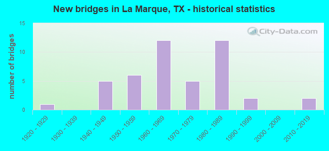
- New bridges - historical statistics
- 11920-1929
- 51940-1949
- 61950-1959
- 121960-1969
- 51970-1979
- 121980-1989
- 21990-1999
- 22010-2019
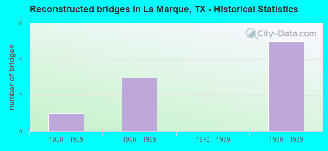
- Reconstructed bridges - Historical Statistics
- 11950-1959
- 31960-1969
- 01970-1979
- 51980-1989
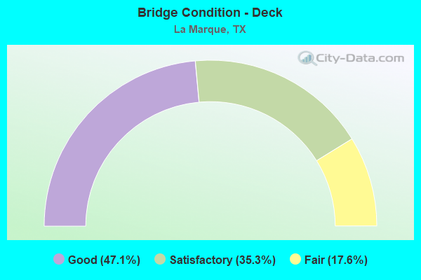
- Bridge Condition - Deck
- 47.1%Good
- 35.3%Satisfactory
- 17.6%Fair
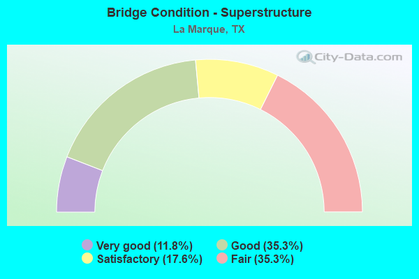
- Bridge Condition - Superstructure
- 11.8%Very good
- 35.3%Good
- 17.6%Satisfactory
- 35.3%Fair
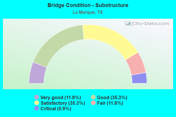
- Bridge Condition - Substructure
- 11.8%Very good
- 35.3%Good
- 35.3%Satisfactory
- 11.8%Fair
- 5.9%Critical
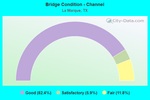
- Bridge Condition - Channel
- 82.4%Good
- 5.9%Satisfactory
- 11.8%Fair
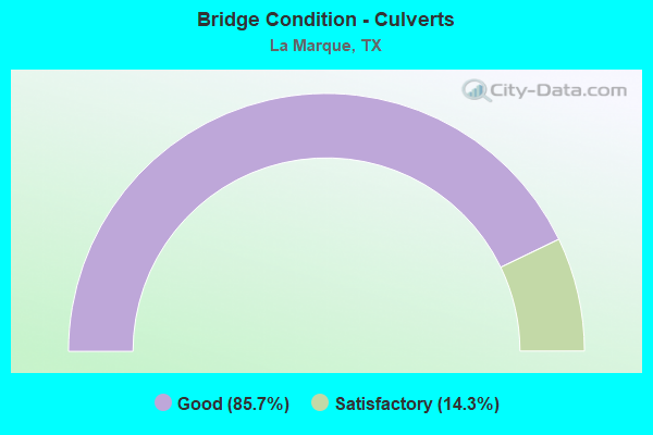
- Bridge Condition - Culverts
- 85.7%Good
- 14.3%Satisfactory
Find on map >> Show street view
Structure Number: 120850005103051, Location: 0.35 MI NW OF FM 519 (Lat: 29.362178, Lng: -94.954400), Route carried "on" structure: State highway 3, Year Built: 1993, Status: Open, Structure Length: 0.79m (2.59ft), Average Daily Traffic: 5,576 (year 2016), Truck Traffic: 6%, Average Future Daily Traffic: 5,040 (year 2033), Design Load: HS 20, Features Intersected: DRAINAGE DITCH
Minimum Vertical Clearance: 30+ m (98+ ft), Kilometerpoint: 24.522, Lanes on structure: 5, Owner: State Highway Agency, Approaching Roadway Width: 19.5m (64.0ft), Skew: 1 degrees, Material/Design: Concrete, Design/Construction: Culvert, Number Of Spans In Main Unit: 3, Length of Maximum Span: 2.1m (6.9ft), Curb-To-Curb Width: 19.4m (63.6ft), Out-to-Out Width: 23.8m (78.1ft)
Condition: Channel: Good, Culverts: Good, Operating Rating: 39.9 metric tons, Method Used To Determine Operating Rating: Load Factor (LF), Inventory Rating: 23.6 metric tons, Method Used To Determine Inventory Rating: Load Factor (LF), Structural Evaluation: Somewhat better than minimum adequacy, Deck Geometry: Meets minimum limits, Waterway Adequacy: Equal to present minimum criteria, Approach Roadway Alignment: Equal to present desirable criteria, Designated Inspection Frequency: Every 48 months, Inspection Date: September 2020, Deck Structure Type: Concrete Cast-file-Place, Wearing Surface/Protective System: Wearing Surface: Bituminous
Find on map >> Show street view
Structure Number: 120850005103071, Location: 0.70 MI NW OF LP 197 (Lat: 29.344222, Lng: -94.938417), Route carried "on" structure: State highway 3, Year Built: 1969, Status: Open, Structure Length: 11.43m (37.50ft), Average Daily Traffic: 1,600 (year 2013), Truck Traffic: 6%, Average Future Daily Traffic: 2,240 (year 2033), Design Load: HS 20, Features Intersected: SH 146
Minimum Vertical Clearance: 30+ m (98+ ft), Kilometerpoint: 26.952, Lanes on structure: 2, Lanes under structure: 5, Owner: State Highway Agency, Approaching Roadway Width: 10.4m (34.1ft), Skew: 4 degrees, Material/Design: Prestressed concrete, Design/Construction: Stringer/Multi-beam, Number Of Spans In Main Unit: 4, Number Of Approach Spans: 1, Length of Maximum Span: 27.4m (89.9ft), Curb-To-Curb Width: 10.5m (34.4ft), Out-to-Out Width: 11.6m (38.1ft)
Condition: Deck: Good, Superstructure: Satisfactory, Substructure: Good, Operating Rating: 68.0 metric tons, Method Used To Determine Operating Rating: Load Factor (LF), Inventory Rating: 34.5 metric tons, Method Used To Determine Inventory Rating: Load Factor (LF), Structural Evaluation: Equal to present minimum criteria, Deck Geometry: Somewhat better than minimum adequacy, Underclear: Equal to present minimum criteria, Approach Roadway Alignment: Equal to present desirable criteria, Designated Inspection Frequency: Every 24 months, Inspection Date: August 2020, Deck Structure Type: Concrete Cast-file-Place
Find on map >> Show street view
Structure Number: 12085001920407, Location: 0.12 MI W OF IH 45 (Lat: 29.330269, Lng: -94.935625), Route carried "on" structure: Ramp State highway 6, Year Built: 1965, Status: Open, Structure Length: 5.79m (19.00ft), Average Daily Traffic: 4,300 (year 2011), Truck Traffic: 8%, Average Future Daily Traffic: 6,020 (year 2031), Design Load: HS 20, Features Intersected: SH 6 EB TO SH 146 NB
Minimum Vertical Clearance: 30+ m (98+ ft), Kilometerpoint: 27.156, Lanes on structure: 2, Lanes under structure: 1, Owner: State Highway Agency, Approaching Roadway Width: 9.8m (32.2ft), Skew: 5 degrees, Material/Design: Prestressed concrete, Design/Construction: Stringer/Multi-beam, Number Of Spans In Main Unit: 3, Length of Maximum Span: 21.3m (69.9ft), Curb-To-Curb Width: 9.9m (32.5ft), Out-to-Out Width: 11.0m (36.1ft)
Condition: Deck: Good, Superstructure: Satisfactory, Substructure: Good, Operating Rating: 68.0 metric tons, Method Used To Determine Operating Rating: Load Factor (LF), Inventory Rating: 39.0 metric tons, Method Used To Determine Inventory Rating: Load Factor (LF), Structural Evaluation: Equal to present minimum criteria, Deck Geometry: Equal to present minimum criteria, Underclear: High priority of corrective action, Approach Roadway Alignment: Somewhat better than minimum adequacy, Length Of Structure Improvement: 5.79m (19.00ft), Designated Inspection Frequency: Every 24 months, Inspection Date: August 2020, Deck Structure Type: Concrete Cast-file-Place
Find on map >> Show street view
Structure Number: 120850019204141, Location: 0.20 MI N OF IH 45 (Lat: 29.333183, Lng: -94.931650), Route carried "on" structure: Ramp State highway 6, Year Built: 1965, Status: Open, Structure Length: 5.49m (18.01ft), Average Daily Traffic: 4,300 (year 2011), Truck Traffic: 8%, Average Future Daily Traffic: 6,020 (year 2031), Design Load: HS 20, Features Intersected: SH 146 SB
Minimum Vertical Clearance: 30+ m (98+ ft), Kilometerpoint: 27.230, Lanes on structure: 2, Lanes under structure: 2, Owner: State Highway Agency, Approaching Roadway Width: 9.8m (32.2ft), Skew: 5 degrees, Material/Design: Prestressed concrete, Design/Construction: Stringer/Multi-beam, Number Of Spans In Main Unit: 3, Length of Maximum Span: 21.3m (69.9ft), Curb-To-Curb Width: 8.5m (27.9ft), Out-to-Out Width: 10.0m (32.8ft)
Condition: Deck: Good, Superstructure: Satisfactory, Substructure: Fair, Operating Rating: 68.0 metric tons, Method Used To Determine Operating Rating: Load Factor (LF), Inventory Rating: 40.8 metric tons, Method Used To Determine Inventory Rating: Load Factor (LF), Structural Evaluation: Somewhat better than minimum adequacy, Deck Geometry: High priority of corrective action, Underclear: High priority of corrective action, Approach Roadway Alignment: Equal to present desirable criteria, Length Of Structure Improvement: 5.49m (18.01ft), Designated Inspection Frequency: Every 24 months, Inspection Date: August 2020, Bridge Improvement Cost: $10,000, Roadway Improvement Cost: $3,000, Total Project Cost: $13,000, Deck Structure Type: Concrete Cast-file-Place
Find on map >> Show street view
Structure Number: 120850050004033, Location: 0.40 MI SE OF FM 519 (Lat: 29.354894, Lng: -94.973131), Route carried "on" structure: Interstate 45, Year Built: 1948, Year Reconstructed: 1980, Status: Open, Structure Length: 1.80m (5.91ft), Average Daily Traffic: 40,876 (year 2020), Truck Traffic: 4%, Average Future Daily Traffic: 63,660 (year 2033), Design Load: H 15, Features Intersected: DRAINAGE DITCH
Minimum Vertical Clearance: 30+ m (98+ ft), Kilometerpoint: 5.573, Lanes on structure: 10, Owner: State Highway Agency, Approaching Roadway Width: 55.8m (183.1ft), Skew: 33 degrees, Material/Design: Concrete, Design/Construction: Culvert, Number Of Spans In Main Unit: 7, Length of Maximum Span: 2.1m (6.9ft)
Condition: Channel: Fair, Culverts: Satisfactory, Operating Rating: 39.9 metric tons, Method Used To Determine Operating Rating: Load Factor (LF), Inventory Rating: 23.6 metric tons, Method Used To Determine Inventory Rating: Load Factor (LF), Structural Evaluation: Somewhat better than minimum adequacy, Waterway Adequacy: Equal to present minimum criteria, Approach Roadway Alignment: Equal to present desirable criteria, Designated Inspection Frequency: Every 24 months, Inspection Date: September 2020
Find on map >> Show street view
Structure Number: 120850050004034, Location: 1.50 MI SE OF FM 519 (Lat: 29.347817, Lng: -94.957192), Route carried "on" structure: Interstate 45, Year Built: 1948, Year Reconstructed: 1980, Status: Open, Structure Length: 1.16m (3.81ft), Average Daily Traffic: 40,876 (year 2020), Truck Traffic: 4%, Average Future Daily Traffic: 63,660 (year 2033), Design Load: H 15, Features Intersected: DRAINAGE DITCH
Minimum Vertical Clearance: 30+ m (98+ ft), Kilometerpoint: 3.837, Lanes on structure: 11, Owner: State Highway Agency, Approaching Roadway Width: 59.7m (195.9ft), Skew: 30 degrees, Material/Design: Concrete, Design/Construction: Culvert, Number Of Spans In Main Unit: 6, Length of Maximum Span: 1.8m (5.9ft)
Condition: Channel: Good, Culverts: Good, Operating Rating: 39.9 metric tons, Method Used To Determine Operating Rating: Load Factor (LF), Inventory Rating: 23.6 metric tons, Method Used To Determine Inventory Rating: Load Factor (LF), Structural Evaluation: Somewhat better than minimum adequacy, Waterway Adequacy: Equal to present minimum criteria, Approach Roadway Alignment: Equal to present desirable criteria, Designated Inspection Frequency: Every 24 months, Inspection Date: September 2020
Find on map >> Show street view
Structure Number: 120850050004122, Location: 1.00 MI NW OF FM 519 (Lat: 29.366100, Lng: -94.992575), Route carried "on" structure: City street , Year Built: 1961, Status: Not yet open, Structure Length: 12.19m (39.99ft), Average Daily Traffic: 2,740 (year 2010), Average Future Daily Traffic: 2,740 (year 2030), Design Load: HS 20, Features Intersected: IH 45, Facility Carried by Structure: VAUTHIER RD
Minimum Vertical Clearance: 30+ m (98+ ft), Kilometerpoint: 0.805, Lanes on structure: 2, Lanes under structure: 10, Owner: State Highway Agency, Approaching Roadway Width: 7.3m (24.0ft), Skew: 4 degrees, Material/Design: Steel continuous, Design/Construction: Stringer/Multi-beam, Number Of Spans In Main Unit: 2, Number Of Approach Spans: 4, Length of Maximum Span: 27.4m (89.9ft), Curb or Sidewalk Widths: Left: 1.1m (3.6ft), Right: 0.0m, Curb-To-Curb Width: 8.6m (28.2ft), Out-to-Out Width: 11.0m (36.1ft)
Condition: Deck: Satisfactory, Superstructure: Fair, Substructure: Satisfactory, Operating Rating: 39.0 metric tons, Method Used To Determine Operating Rating: Load Factor (LF), Inventory Rating: 22.7 metric tons, Method Used To Determine Inventory Rating: Load Factor (LF), Structural Evaluation: Somewhat better than minimum adequacy, Deck Geometry: Meets minimum limits, Underclear: Equal to present minimum criteria, Approach Roadway Alignment: Equal to present desirable criteria, Designated Inspection Frequency: Every 24 months, Inspection Date: September 2020, Deck Structure Type: Concrete Cast-file-Place
Find on map >> Show street view
Structure Number: 120850050004134, Location: 1.3 MI NW OF SH 6 (Lat: 29.343392, Lng: -94.949350), Route carried "on" structure: Interstate 45, Year Built: 1965, Status: Open, Structure Length: 10.36m (33.99ft), Average Daily Traffic: 23,779 (year 2018), Truck Traffic: 4%, Average Future Daily Traffic: 31,830 (year 2033), Design Load: HS 20, Features Intersected: TCT RR
Minimum Vertical Clearance: 30+ m (98+ ft), Kilometerpoint: 2.895, Lanes on structure: 3, Owner: State Highway Agency, Approaching Roadway Width: 17.1m (56.1ft), Skew: 1 degrees, Material/Design: Prestressed concrete, Design/Construction: Stringer/Multi-beam, Number Of Spans In Main Unit: 3, Number Of Approach Spans: 3, Length of Maximum Span: 21.3m (69.9ft), Curb-To-Curb Width: 17.1m (56.1ft), Out-to-Out Width: 18.1m (59.4ft)
Condition: Deck: Satisfactory, Superstructure: Good, Substructure: Satisfactory, Operating Rating: 44.4 metric tons, Method Used To Determine Operating Rating: Assigned ratings based on Allowable Stress Design (ASD) reported in metric tons, Inventory Rating: 32.7 metric tons, Method Used To Determine Inventory Rating: Assigned ratings based on Allowable Stress Design (ASD) reported in metric tons, Structural Evaluation: Equal to present minimum criteria, Deck Geometry: Equal to present minimum criteria, Underclear: Better than present minimum criteria, Approach Roadway Alignment: Equal to present desirable criteria, Designated Inspection Frequency: Every 24 months, Inspection Date: October 2020, Deck Structure Type: Concrete Cast-file-Place
Find on map >> Show street view
Structure Number: 12085005000419, Location: 1.15 MI SE OF FM 1764 (Lat: 29.390192, Lng: -95.020733), Route carried "on" structure: City street , Year Built: 1979, Status: Open, Structure Length: 17.16m (56.30ft), Average Daily Traffic: 1,500 (year 2012), Truck Traffic: 2%, Average Future Daily Traffic: 2,500 (year 2032), Design Load: HS 20, Features Intersected: IH 45, Facility Carried by Structure: CENTURY BLVD
Minimum Vertical Clearance: 30+ m (98+ ft), Kilometerpoint: 0.805, Lanes on structure: 2, Lanes under structure: 10, Owner: State Highway Agency, Approaching Roadway Width: 13.4m (44.0ft), Skew: 4 degrees, Material/Design: Prestressed concrete, Design/Construction: Stringer/Multi-beam, Number Of Spans In Main Unit: 4, Number Of Approach Spans: 2, Length of Maximum Span: 34.7m (113.8ft), Curb-To-Curb Width: 13.4m (44.0ft), Out-to-Out Width: 13.9m (45.6ft)
Condition: Deck: Good, Superstructure: Good, Substructure: Satisfactory, Operating Rating: 66.2 metric tons, Method Used To Determine Operating Rating: Load Factor (LF), Inventory Rating: 28.1 metric tons, Method Used To Determine Inventory Rating: Load Factor (LF), Structural Evaluation: Equal to present minimum criteria, Deck Geometry: Equal to present desirable criteria, Underclear: Somewhat better than minimum adequacy, Approach Roadway Alignment: Equal to present desirable criteria, Designated Inspection Frequency: Every 24 months, Inspection Date: September 2020, Deck Structure Type: Concrete Cast-file-Place
Find on map >> Show street view
Structure Number: 120850050004193, Location: 2.40 MI NW OF FM 1765 (Lat: 29.402628, Lng: -95.032958), Route carried "on" structure: Interstate 45, Year Built: 1979, Status: Open, Structure Length: 9.45m (31.00ft), Average Daily Traffic: 47,565 (year 2020), Truck Traffic: 6%, Average Future Daily Traffic: 72,100 (year 2033), Design Load: HS 20, Features Intersected: FM 1764 / FM 2004
Minimum Vertical Clearance: 30+ m (98+ ft), Kilometerpoint: 13.453, Lanes on structure: 6, Lanes under structure: 8, Owner: State Highway Agency, Approaching Roadway Width: 37.2m (122.0ft), Skew: 30 degrees, Material/Design: Prestressed concrete, Design/Construction: Stringer/Multi-beam, Number Of Spans In Main Unit: 3, Length of Maximum Span: 33.5m (109.9ft), Curb-To-Curb Width: 37.1m (121.7ft), Out-to-Out Width: 38.3m (125.7ft)
Condition: Deck: Good, Superstructure: Good, Substructure: Good, Operating Rating: 54.4 metric tons, Method Used To Determine Operating Rating: Assigned rating based on Load Factor Design (LFD) reported in metric tons, Inventory Rating: 32.7 metric tons, Method Used To Determine Inventory Rating: Assigned rating based on Load Factor Design (LFD) reported in metric tons, Structural Evaluation: Better than present minimum criteria, Deck Geometry: Superior to present desirable criteria, Underclear: Equal to present minimum criteria, Approach Roadway Alignment: Equal to present desirable criteria, Designated Inspection Frequency: Every 24 months, Inspection Date: August 2020, Deck Structure Type: Concrete Cast-file-Place
Find on map >> Show street view
Structure Number: 120850050004202, Location: 0.20 MI NW OF FM 1765 (Lat: 29.378614, Lng: -95.008253), Route carried "on" structure: Interstate 45, Year Built: 1980, Status: Open, Structure Length: 1.16m (3.81ft), Average Daily Traffic: 47,565 (year 2020), Truck Traffic: 6%, Average Future Daily Traffic: 72,100 (year 2033), Design Load: HS 20, Features Intersected: DRAINAGE DITCH
Minimum Vertical Clearance: 30+ m (98+ ft), Kilometerpoint: 9.926, Lanes on structure: 13, Owner: State Highway Agency, Approaching Roadway Width: 59.1m (193.9ft), Skew: 34 degrees, Material/Design: Concrete, Design/Construction: Culvert, Number Of Spans In Main Unit: 3, Length of Maximum Span: 2.7m (8.9ft)
Condition: Channel: Satisfactory, Culverts: Good, Operating Rating: 39.9 metric tons, Method Used To Determine Operating Rating: Load Factor (LF), Inventory Rating: 23.6 metric tons, Method Used To Determine Inventory Rating: Load Factor (LF), Structural Evaluation: Somewhat better than minimum adequacy, Waterway Adequacy: Equal to present minimum criteria, Approach Roadway Alignment: Equal to present desirable criteria, Length Of Structure Improvement: 1.19m (3.90ft), Designated Inspection Frequency: Every 48 months, Inspection Date: October 2020, Bridge Improvement Cost: $59,000, Roadway Improvement Cost: $15,000, Total Project Cost: $74,000
Find on map >> Show street view
Structure Number: 120850050004219, Location: @TEX. CITY Y-INTERSECTION (Lat: 29.329083, Lng: -94.931233), Route carried "on" structure: Interstate 45, Year Built: 1951, Year Reconstructed: 1965, Status: Open, Structure Length: 6.61m (21.69ft), Average Daily Traffic: 33,950 (year 2013), Truck Traffic: 4%, Average Future Daily Traffic: 47,540 (year 2033), Design Load: HS 20, Features Intersected: SH 146 SB
Minimum Vertical Clearance: 30+ m (98+ ft), Kilometerpoint: 0.565, Lanes on structure: 4, Lanes under structure: 2, Owner: State Highway Agency, Approaching Roadway Width: 19.5m (64.0ft), Skew: 5 degrees, Material/Design: Steel continuous, Design/Construction: Stringer/Multi-beam, Number Of Spans In Main Unit: 3, Length of Maximum Span: 25.9m (85.0ft), Curb-To-Curb Width: 18.6m (61.0ft), Out-to-Out Width: 20.1m (65.9ft)
Condition: Deck: Fair, Superstructure: Fair, Substructure: Fair, Operating Rating: 49.0 metric tons, Method Used To Determine Operating Rating: Load Factor (LF), Inventory Rating: 29.0 metric tons, Method Used To Determine Inventory Rating: Load Factor (LF), Structural Evaluation: Somewhat better than minimum adequacy, Deck Geometry: Meets minimum limits, Underclear: Meets minimum limits, Approach Roadway Alignment: Equal to present desirable criteria, Length Of Structure Improvement: 6.49m (21.29ft), Designated Inspection Frequency: Every 24 months, Inspection Date: September 2020, Bridge Improvement Cost: $26,000, Roadway Improvement Cost: $7,000, Total Project Cost: $33,000, Deck Structure Type: Concrete Cast-file-Place, Wearing Surface/Protective System: Wearing Surface: Bituminous
Find on map >> Show street view
Structure Number: 12085005000422, Location: @TEX.CITY INERSECTION (Lat: 29.330550, Lng: -94.934117), Route carried "on" structure: Interstate 45, Year Built: 1951, Year Reconstructed: 1965, Status: Open, Structure Length: 7.47m (24.51ft), Average Daily Traffic: 21,538 (year 2018), Truck Traffic: 4%, Average Future Daily Traffic: 31,830 (year 2033), Design Load: HS 20, Features Intersected: SH 6 CONNECTORS
Minimum Vertical Clearance: 30+ m (98+ ft), Kilometerpoint: 0.838, Lanes on structure: 3, Lanes under structure: 4, Owner: State Highway Agency, Approaching Roadway Width: 15.9m (52.2ft), Skew: 4 degrees, Material/Design: Steel continuous, Design/Construction: Stringer/Multi-beam, Number Of Spans In Main Unit: 3, Number Of Approach Spans: 1, Length of Maximum Span: 21.3m (69.9ft), Curb-To-Curb Width: 14.6m (47.9ft), Out-to-Out Width: 16.5m (54.1ft)
Condition: Deck: Fair, Superstructure: Fair, Substructure: Satisfactory, Operating Rating: 41.7 metric tons, Method Used To Determine Operating Rating: Load Factor (LF), Inventory Rating: 24.5 metric tons, Method Used To Determine Inventory Rating: Load Factor (LF), Structural Evaluation: Somewhat better than minimum adequacy, Deck Geometry: Meets minimum limits, Underclear: High priority of corrective action, Approach Roadway Alignment: Equal to present desirable criteria, Length Of Structure Improvement: 7.47m (24.51ft), Designated Inspection Frequency: Every 24 months, Inspection Date: September 2020, Bridge Improvement Cost: $24,000, Roadway Improvement Cost: $6,000, Total Project Cost: $30,000, Deck Structure Type: Concrete Cast-file-Place, Wearing Surface/Protective System: Wearing Surface: Bituminous
Find on map >> Show street view
Structure Number: 120850050004221, Location: @TEX.CITY Y-INTERSECTION (Lat: 29.330750, Lng: -94.933331), Route carried "on" structure: Interstate 45, Year Built: 1951, Year Reconstructed: 1965, Status: Open, Structure Length: 4.63m (15.19ft), Average Daily Traffic: 22,730 (year 2013), Truck Traffic: 4%, Average Future Daily Traffic: 31,830 (year 2033), Design Load: HS 20, Features Intersected: SH 6 & SH 146
Minimum Vertical Clearance: 30+ m (98+ ft), Kilometerpoint: 0.814, Lanes on structure: 3, Lanes under structure: 3, Owner: State Highway Agency, Approaching Roadway Width: 15.9m (52.2ft), Skew: 3 degrees, Material/Design: Steel continuous, Design/Construction: Stringer/Multi-beam, Number Of Spans In Main Unit: 1, Number Of Approach Spans: 2, Length of Maximum Span: 18.3m (60.0ft), Curb-To-Curb Width: 14.6m (47.9ft), Out-to-Out Width: 16.5m (54.1ft)
Condition: Deck: Fair, Superstructure: Fair, Substructure: Satisfactory, Operating Rating: 48.1 metric tons, Method Used To Determine Operating Rating: Load Factor (LF), Inventory Rating: 28.1 metric tons, Method Used To Determine Inventory Rating: Load Factor (LF), Structural Evaluation: Somewhat better than minimum adequacy, Deck Geometry: Meets minimum limits, Underclear: High priority of corrective action, Approach Roadway Alignment: Equal to present desirable criteria, Length Of Structure Improvement: 4.54m (14.90ft), Designated Inspection Frequency: Every 24 months, Inspection Date: September 2020, Bridge Improvement Cost: $14,000, Roadway Improvement Cost: $4,000, Total Project Cost: $18,000, Deck Structure Type: Concrete Cast-file-Place, Wearing Surface/Protective System: Wearing Surface: Bituminous
Find on map >> Show street view
Structure Number: 120850050004231, Location: 2.10 MI SE OF FM 1765 (Lat: 29.357706, Lng: -94.979519), Route carried "on" structure: Interstate 45, Year Built: 1980, Status: Open, Structure Length: 9.75m (31.99ft), Average Daily Traffic: 40,876 (year 2020), Truck Traffic: 4%, Average Future Daily Traffic: 63,660 (year 2033), Design Load: HS 20, Features Intersected: FM 519
Minimum Vertical Clearance: 30+ m (98+ ft), Kilometerpoint: 6.276, Lanes on structure: 6, Lanes under structure: 8, Owner: State Highway Agency, Approaching Roadway Width: 37.8m (124.0ft), Skew: 30 degrees, Material/Design: Prestressed concrete, Design/Construction: Stringer/Multi-beam, Number Of Spans In Main Unit: 3, Length of Maximum Span: 33.5m (109.9ft), Curb-To-Curb Width: 37.1m (121.7ft), Out-to-Out Width: 38.3m (125.7ft)
Condition: Deck: Satisfactory, Superstructure: Good, Substructure: Good, Operating Rating: 44.4 metric tons, Method Used To Determine Operating Rating: Assigned rating based on Load Factor Design (LFD) reported in metric tons, Inventory Rating: 32.7 metric tons, Method Used To Determine Inventory Rating: Assigned rating based on Load Factor Design (LFD) reported in metric tons, Structural Evaluation: Better than present minimum criteria, Deck Geometry: Superior to present desirable criteria, Underclear: Meets minimum limits, Approach Roadway Alignment: Equal to present desirable criteria, Designated Inspection Frequency: Every 24 months, Inspection Date: September 2020, Deck Structure Type: Concrete Cast-file-Place
Find on map >> Show street view
Structure Number: 120850050004232, Location: 0.80 MI SE OF FM 519 (Lat: 29.352378, Lng: -94.967472), Route carried "on" structure: Interstate 45, Year Built: 1948, Year Reconstructed: 1980, Status: Open, Structure Length: 1.19m (3.90ft), Average Daily Traffic: 40,876 (year 2020), Truck Traffic: 4%, Average Future Daily Traffic: 63,660 (year 2033), Design Load: H 15, Features Intersected: DRAINAGE DITCH
Minimum Vertical Clearance: 30+ m (98+ ft), Kilometerpoint: 4.963, Lanes on structure: 12, Owner: State Highway Agency, Approaching Roadway Width: 66.4m (217.8ft), Skew: 9 degrees, Material/Design: Concrete, Design/Construction: Culvert, Number Of Spans In Main Unit: 5, Length of Maximum Span: 1.8m (5.9ft)
Condition: Channel: Good, Culverts: Good, Operating Rating: 39.9 metric tons, Method Used To Determine Operating Rating: Load Factor (LF), Inventory Rating: 23.6 metric tons, Method Used To Determine Inventory Rating: Load Factor (LF), Structural Evaluation: Somewhat better than minimum adequacy, Waterway Adequacy: Equal to present minimum criteria, Approach Roadway Alignment: Equal to present desirable criteria, Designated Inspection Frequency: Every 24 months, Inspection Date: September 2020
Find on map >> Show street view
Structure Number: 120850050004237, Location: 2.10 MI NW OF FM 519 (Lat: 29.376642, Lng: -95.005817), Route carried "on" structure: Interstate 45, Year Built: 1982, Status: Open, Structure Length: 9.45m (31.00ft), Average Daily Traffic: 59,505 (year 2019), Truck Traffic: 4%, Average Future Daily Traffic: 76,240 (year 2033), Design Load: HS 20, Features Intersected: FM 1765
Minimum Vertical Clearance: 30+ m (98+ ft), Kilometerpoint: 9.553, Lanes on structure: 6, Lanes under structure: 8, Owner: State Highway Agency, Approaching Roadway Width: 36.6m (120.1ft), Skew: 30 degrees, Material/Design: Prestressed concrete, Design/Construction: Stringer/Multi-beam, Number Of Spans In Main Unit: 3, Length of Maximum Span: 33.5m (109.9ft), Curb-To-Curb Width: 37.1m (121.7ft), Out-to-Out Width: 38.3m (125.7ft)
Condition: Deck: Satisfactory, Superstructure: Good, Substructure: Good, Operating Rating: 54.4 metric tons, Method Used To Determine Operating Rating: Assigned rating based on Load Factor Design (LFD) reported in metric tons, Inventory Rating: 32.7 metric tons, Method Used To Determine Inventory Rating: Assigned rating based on Load Factor Design (LFD) reported in metric tons, Structural Evaluation: Better than present minimum criteria, Deck Geometry: Superior to present desirable criteria, Underclear: Equal to present minimum criteria, Approach Roadway Alignment: Equal to present desirable criteria, Designated Inspection Frequency: Every 24 months, Inspection Date: September 2020, Deck Structure Type: Concrete Cast-file-Place
Find on map >> Show street view
Structure Number: 120850050004238, Location: 1.40 MI NW OF FM 519 (Lat: 29.370383, Lng: -94.997964), Route carried "on" structure: Interstate 45, Year Built: 1982, Status: Open, Structure Length: 0.98m (3.22ft), Average Daily Traffic: 59,505 (year 2019), Truck Traffic: 4%, Average Future Daily Traffic: 76,240 (year 2033), Design Load: HS 20, Features Intersected: DRAINAGE DITCH
Minimum Vertical Clearance: 30+ m (98+ ft), Kilometerpoint: 8.570, Lanes on structure: 12, Owner: State Highway Agency, Approaching Roadway Width: 64.0m (210.0ft), Material/Design: Concrete, Design/Construction: Culvert, Number Of Spans In Main Unit: 3, Length of Maximum Span: 3.0m (9.8ft)
Condition: Channel: Good, Culverts: Good, Operating Rating: 39.9 metric tons, Method Used To Determine Operating Rating: Load Factor (LF), Inventory Rating: 23.6 metric tons, Method Used To Determine Inventory Rating: Load Factor (LF), Structural Evaluation: Somewhat better than minimum adequacy, Waterway Adequacy: Equal to present minimum criteria, Approach Roadway Alignment: Equal to present desirable criteria, Designated Inspection Frequency: Every 48 months, Inspection Date: September 2020
Find on map >> Show street view
Structure Number: 12085005000429, Location: 0.30 MI NW OF FM 1764 (Lat: 29.406542, Lng: -95.036817), Route carried "on" structure: Ramp State highway 1764, Year Built: 1989, Status: Open, Structure Length: 23.32m (76.51ft), Average Daily Traffic: 15,630 (year 2013), Truck Traffic: 4%, Average Future Daily Traffic: 21,890 (year 2033), Design Load: HS 20, Features Intersected: IH 45
Minimum Vertical Clearance: 30+ m (98+ ft), Kilometerpoint: 8.304, Lanes on structure: 2, Lanes under structure: 7, Owner: State Highway Agency, Approaching Roadway Width: 11.6m (38.1ft), Skew: 9 degrees, Material/Design: Prestressed concrete, Design/Construction: Stringer/Multi-beam, Number Of Spans In Main Unit: 2, Number Of Approach Spans: 7, Length of Maximum Span: 36.6m (120.1ft), Curb-To-Curb Width: 11.3m (37.1ft), Out-to-Out Width: 12.2m (40.0ft)
Condition: Deck: Good, Superstructure: Fair, Substructure: Good, Operating Rating: 44.4 metric tons, Method Used To Determine Operating Rating: Assigned rating based on Load Factor Design (LFD) reported in metric tons, Inventory Rating: 32.7 metric tons, Method Used To Determine Inventory Rating: Assigned rating based on Load Factor Design (LFD) reported in metric tons, Structural Evaluation: Somewhat better than minimum adequacy, Deck Geometry: Superior to present desirable criteria, Underclear: High priority of corrective action, Approach Roadway Alignment: Equal to present desirable criteria, Designated Inspection Frequency: Every 24 months, Inspection Date: August 2020, Deck Structure Type: Concrete Cast-file-Place
Find on map >> Show street view
Structure Number: 120850050004322, Location: 1.10 MI SE OF FM 519 (Lat: 29.350583, Lng: -94.963422), Route carried "on" structure: Interstate 45, Year Built: 1948, Year Reconstructed: 1980, Status: Open, Structure Length: 1.16m (3.81ft), Average Daily Traffic: 40,876 (year 2020), Truck Traffic: 4%, Average Future Daily Traffic: 63,660 (year 2033), Design Load: H 15, Features Intersected: DRAINAGE DITCH
Minimum Vertical Clearance: 30+ m (98+ ft), Kilometerpoint: 4.517, Lanes on structure: 10, Owner: State Highway Agency, Approaching Roadway Width: 54.3m (178.1ft), Skew: 9 degrees, Material/Design: Concrete, Design/Construction: Culvert, Number Of Spans In Main Unit: 5, Length of Maximum Span: 1.5m (4.9ft)
Condition: Channel: Good, Culverts: Good, Operating Rating: 39.9 metric tons, Method Used To Determine Operating Rating: Load Factor (LF), Inventory Rating: 23.6 metric tons, Method Used To Determine Inventory Rating: Load Factor (LF), Structural Evaluation: Somewhat better than minimum adequacy, Waterway Adequacy: Equal to present minimum criteria, Approach Roadway Alignment: Equal to present desirable criteria, Designated Inspection Frequency: Every 24 months, Inspection Date: September 2020
Find on map >> Show street view
Structure Number: 120850050004341, Location: 1.3 MI NW OF SH 6 (Lat: 29.343256, Lng: -94.949483), Route carried "on" structure: Interstate 45, Year Built: 1965, Status: Open, Structure Length: 10.36m (33.99ft), Average Daily Traffic: 21,538 (year 2018), Truck Traffic: 4%, Average Future Daily Traffic: 31,830 (year 2033), Design Load: HS 20, Features Intersected: TCT RR
Minimum Vertical Clearance: 30+ m (98+ ft), Kilometerpoint: 2.895, Lanes on structure: 3, Owner: State Highway Agency, Approaching Roadway Width: 17.1m (56.1ft), Skew: 1 degrees, Material/Design: Prestressed concrete, Design/Construction: Stringer/Multi-beam, Number Of Spans In Main Unit: 3, Number Of Approach Spans: 3, Length of Maximum Span: 21.3m (69.9ft), Curb-To-Curb Width: 17.1m (56.1ft), Out-to-Out Width: 17.9m (58.7ft)
Condition: Deck: Satisfactory, Superstructure: Good, Substructure: Satisfactory, Operating Rating: 44.4 metric tons, Method Used To Determine Operating Rating: Assigned ratings based on Allowable Stress Design (ASD) reported in metric tons, Inventory Rating: 32.7 metric tons, Method Used To Determine Inventory Rating: Assigned ratings based on Allowable Stress Design (ASD) reported in metric tons, Structural Evaluation: Equal to present minimum criteria, Deck Geometry: Equal to present minimum criteria, Underclear: Better than present minimum criteria, Approach Roadway Alignment: Equal to present desirable criteria, Length Of Structure Improvement: 10.39m (34.09ft), Designated Inspection Frequency: Every 24 months, Inspection Date: October 2020, Bridge Improvement Cost: $321,000, Roadway Improvement Cost: $80,000, Total Project Cost: $401,000, Deck Structure Type: Concrete Cast-file-Place
Find on map >> Show street view
Structure Number: 120850068602239, Location: 0.20 MI SW OF IH 45 (Lat: 29.375600, Lng: -95.008325), Route carried "on" structure: State highway 1765, Year Built: 1982, Status: Open, Structure Length: 1.49m (4.89ft), Average Daily Traffic: 4,787 (year 2016), Truck Traffic: 8%, Average Future Daily Traffic: 4,770 (year 2033), Design Load: HS 20, Features Intersected: DRAINAGE DITCH
Minimum Vertical Clearance: 30+ m (98+ ft), Kilometerpoint: 3.879, Lanes on structure: 2, Owner: State Highway Agency, Approaching Roadway Width: 14.6m (47.9ft), Skew: 4 degrees, Material/Design: Concrete, Design/Construction: Culvert, Number Of Spans In Main Unit: 4, Length of Maximum Span: 2.4m (7.9ft)
Condition: Channel: Good, Culverts: Good, Operating Rating: 39.9 metric tons, Method Used To Determine Operating Rating: Load Factor (LF), Inventory Rating: 23.6 metric tons, Method Used To Determine Inventory Rating: Load Factor (LF), Structural Evaluation: Equal to present minimum criteria, Waterway Adequacy: Equal to present minimum criteria, Approach Roadway Alignment: Equal to present desirable criteria, Designated Inspection Frequency: Every 48 months, Inspection Date: September 2020
Find on map >> Show street view
Structure Number: 12085006860224, Location: 0.3 MI E OF FM 2004 (Lat: 29.377897, Lng: -95.026033), Route carried "on" structure: State highway 1765, Year Built: 2012, Status: Open, Structure Length: 4.21m (13.81ft), Average Daily Traffic: 4,787 (year 2016), Truck Traffic: 8%, Average Future Daily Traffic: 4,770 (year 2033), Design Load: HL 93, Features Intersected: DRAINAGE DITCH
Minimum Vertical Clearance: 30+ m (98+ ft), Kilometerpoint: 2.089, Lanes on structure: 2, Owner: State Highway Agency, Approaching Roadway Width: 7.6m (24.9ft), Material/Design: Prestressed concrete, Design/Construction: Slab, Number Of Spans In Main Unit: 3, Length of Maximum Span: 14.3m (46.9ft), Curb-To-Curb Width: 9.8m (32.2ft), Out-to-Out Width: 10.5m (34.4ft)
Condition: Deck: Good, Superstructure: Very good, Substructure: Very good, Channel: Good, Operating Rating: 54.4 metric tons, Method Used To Determine Operating Rating: Assigned ratings based on Load and Resistance Factor Design (LRFD) reported in metric tons, Inventory Rating: 32.7 metric tons, Method Used To Determine Inventory Rating: Assigned ratings based on Load and Resistance Factor Design (LRFD) reported in metric tons, Structural Evaluation: Equal to present desirable criteria, Deck Geometry: Meets minimum limits, Waterway Adequacy: Superior to present desirable criteria, Approach Roadway Alignment: Equal to present desirable criteria, Designated Inspection Frequency: Every 24 months, Inspection Date: August 2020, Deck Structure Type: Concrete Cast-file-Place
Find on map >> Show street view
Structure Number: 120850097901007, Location: 0.40 MI E OF IH 45 (Lat: 29.357992, Lng: -94.973656), Route carried "on" structure: State highway 519, Year Built: 1983, Status: Open, Structure Length: 1.13m (3.71ft), Average Daily Traffic: 7,753 (year 2020), Truck Traffic: 4%, Average Future Daily Traffic: 12,460 (year 2033), Design Load: HS 20, Features Intersected: DRAINAGE DITCH
Minimum Vertical Clearance: 30+ m (98+ ft), Kilometerpoint: 11.127, Lanes on structure: 5, Owner: State Highway Agency, Approaching Roadway Width: 17.7m (58.1ft), Material/Design: Concrete, Design/Construction: Culvert, Number Of Spans In Main Unit: 4, Length of Maximum Span: 2.4m (7.9ft), Curb or Sidewalk Widths: Left: 1.8m (5.9ft), Right: 1.8m (5.9ft), Curb-To-Curb Width: 17.7m (58.1ft), Out-to-Out Width: 24.1m (79.1ft)
Condition: Channel: Good, Culverts: Good, Operating Rating: 39.9 metric tons, Method Used To Determine Operating Rating: Load Factor (LF), Inventory Rating: 23.6 metric tons, Method Used To Determine Inventory Rating: Load Factor (LF), Structural Evaluation: Somewhat better than minimum adequacy, Deck Geometry: High priority of replacement, Waterway Adequacy: Equal to present minimum criteria, Approach Roadway Alignment: Equal to present desirable criteria, Length Of Structure Improvement: 1.13m (3.71ft), Designated Inspection Frequency: Every 48 months, Inspection Date: October 2020, Bridge Improvement Cost: $4,000, Roadway Improvement Cost: $1,000, Total Project Cost: $5,000, Deck Structure Type: Concrete Cast-file-Place, Wearing Surface/Protective System: Wearing Surface: Bituminous
Find on map >> Show street view
Structure Number: 120850097901008, Location: 1.35 MI E OF IH 45 (Lat: 29.358028, Lng: -94.957083), Route carried "on" structure: State highway 519, Year Built: 1983, Status: Open, Structure Length: 1.49m (4.89ft), Average Daily Traffic: 6,580 (year 2020), Truck Traffic: 4%, Average Future Daily Traffic: 8,840 (year 2033), Design Load: HS 20, Features Intersected: DRAINAGE DITCH
Minimum Vertical Clearance: 30+ m (98+ ft), Kilometerpoint: 12.728, Lanes on structure: 5, Owner: State Highway Agency, Approaching Roadway Width: 17.7m (58.1ft), Skew: 3 degrees, Material/Design: Concrete, Design/Construction: Culvert, Number Of Spans In Main Unit: 4, Length of Maximum Span: 2.4m (7.9ft), Curb or Sidewalk Widths: Left: 2.3m (7.5ft), Right: 2.3m (7.5ft), Curb-To-Curb Width: 17.7m (58.1ft), Out-to-Out Width: 39.6m (129.9ft)
Condition: Channel: Good, Culverts: Good, Operating Rating: 39.9 metric tons, Method Used To Determine Operating Rating: Load Factor (LF), Inventory Rating: 23.6 metric tons, Method Used To Determine Inventory Rating: Load Factor (LF), Structural Evaluation: Somewhat better than minimum adequacy, Deck Geometry: High priority of replacement, Waterway Adequacy: Equal to present minimum criteria, Approach Roadway Alignment: Equal to present desirable criteria, Length Of Structure Improvement: 1.49m (4.89ft), Designated Inspection Frequency: Every 48 months, Inspection Date: September 2020, Bridge Improvement Cost: $57,000, Roadway Improvement Cost: $14,000, Total Project Cost: $71,000, Deck Structure Type: Concrete Cast-file-Place, Wearing Surface/Protective System: Wearing Surface: Bituminous
Find on map >> Show street view
Structure Number: 120850160702019, Location: 0.7 MI W OF IH 45 (Lat: 29.395803, Lng: -95.041517), Route carried "on" structure: State highway 1764, Year Built: 1997, Status: Open, Structure Length: 1.13m (3.71ft), Average Daily Traffic: 18,390 (year 2020), Truck Traffic: 4%, Average Future Daily Traffic: 21,890 (year 2033), Design Load: HS 20, Features Intersected: DRAINAGE DITCH 8A2
Minimum Vertical Clearance: 30+ m (98+ ft), Kilometerpoint: 7.730, Lanes on structure: 5, Owner: State Highway Agency, Approaching Roadway Width: 25.3m (83.0ft), Skew: 3 degrees, Material/Design: Concrete, Design/Construction: Culvert, Number Of Spans In Main Unit: 3, Length of Maximum Span: 2.7m (8.9ft)
Condition: Channel: Good, Culverts: Good, Operating Rating: 39.9 metric tons, Method Used To Determine Operating Rating: Load Factor (LF), Inventory Rating: 23.6 metric tons, Method Used To Determine Inventory Rating: Load Factor (LF), Structural Evaluation: Somewhat better than minimum adequacy, Waterway Adequacy: Equal to present minimum criteria, Approach Roadway Alignment: Equal to present desirable criteria, Length Of Structure Improvement: 1.13m (3.71ft), Designated Inspection Frequency: Every 48 months, Inspection Date: September 2020, Deck Structure Type: Concrete Cast-file-Place, Wearing Surface/Protective System: Wearing Surface: Monolithic Concrete
Find on map >> Show street view
Structure Number: 120850191101002, Location: 0.50 MI N OF FM 1765 (Lat: 29.385947, Lng: -95.030903), Route carried "on" structure: State highway 2004, Year Built: 1941, Year Reconstructed: 1993, Status: Open, Structure Length: 0.91m (2.99ft), Average Daily Traffic: 11,323 (year 2020), Truck Traffic: 6%, Average Future Daily Traffic: 12,430 (year 2033), Design Load: H 15, Features Intersected: DRAINAGE DITCH
Minimum Vertical Clearance: 30+ m (98+ ft), Kilometerpoint: 9.873, Lanes on structure: 2, Owner: State Highway Agency, Approaching Roadway Width: 14.0m (45.9ft), Material/Design: Concrete, Design/Construction: Culvert, Number Of Spans In Main Unit: 5, Length of Maximum Span: 1.5m (4.9ft)
Condition: Channel: Good, Culverts: Satisfactory, Operating Rating: 39.9 metric tons, Method Used To Determine Operating Rating: Load Factor (LF), Inventory Rating: 23.6 metric tons, Method Used To Determine Inventory Rating: Load Factor (LF), Structural Evaluation: Somewhat better than minimum adequacy, Waterway Adequacy: Equal to present minimum criteria, Approach Roadway Alignment: Equal to present desirable criteria, Designated Inspection Frequency: Every 24 months, Inspection Date: August 2020
Find on map >> Show street view
Structure Number: 120850K01230067, Location: 0.1 MI N OF FM 519 (Lat: 29.359658, Lng: -94.974389), Route carried "on" structure: City street , Year Built: 1970, Status: Open, Structure Length: 0.73m (2.40ft), Average Daily Traffic: 190 (year 2011), Average Future Daily Traffic: 190 (year 2031), Features Intersected: HIGHLAND BAYOU TRIB, Facility Carried by Structure: EDNA ST
Minimum Vertical Clearance: 30+ m (98+ ft), Kilometerpoint: 0.161, Lanes on structure: 2, Owner: Town or Township Highway Agency, Approaching Roadway Width: 5.5m (18.0ft), Skew: 2 degrees, Material/Design: Concrete, Design/Construction: Culvert, Number Of Spans In Main Unit: 2, Length of Maximum Span: 3.0m (9.8ft), Curb-To-Curb Width: 7.3m (24.0ft), Out-to-Out Width: 8.3m (27.2ft)
Condition: Channel: Good, Culverts: Good, Operating Rating: 32.7 metric tons, Method Used To Determine Operating Rating: Field evaluation and documented engineering judgment, Inventory Rating: 24.5 metric tons, Method Used To Determine Inventory Rating: Field evaluation and documented engineering judgment, Structural Evaluation: Equal to present minimum criteria, Deck Geometry: Somewhat better than minimum adequacy, Waterway Adequacy: Better than present minimum criteria, Approach Roadway Alignment: Equal to present desirable criteria, Designated Inspection Frequency: Every 24 months, Inspection Date: December 2021, Deck Structure Type: Concrete Cast-file-Place, Wearing Surface/Protective System: Wearing Surface: Bituminous
Find on map >> Show street view
Structure Number: 120850K01236228, Location: 0.35 Mi NW of FM 519 (Lat: 29.362281, Lng: -94.953903), Route carried "on" structure: City street , Year Built: 1920, Year Reconstructed: 1950, Status: Open, Structure Length: 0.67m (2.20ft), Average Daily Traffic: 376 (year 2018), Truck Traffic: 3%, Average Future Daily Traffic: 564 (year 2038), Features Intersected: Drainage Ditch, Facility Carried by Structure: S Oak St
Minimum Vertical Clearance: 30+ m (98+ ft), Kilometerpoint: 0.555, Lanes on structure: 2, Owner: City or Municipal Highway Agency, Approaching Roadway Width: 6.4m (21.0ft), Material/Design: Concrete, Design/Construction: Tee Beam, Number Of Spans In Main Unit: 1, Length of Maximum Span: 6.1m (20.0ft), Curb-To-Curb Width: 7.9m (25.9ft), Out-to-Out Width: 8.4m (27.6ft)
Condition: Deck: Satisfactory, Superstructure: Fair, Substructure: Critical, Channel: Fair, Operating Rating: 49.9 metric tons, Method Used To Determine Operating Rating: Load Factor (LF), Inventory Rating: 29.9 metric tons, Method Used To Determine Inventory Rating: Load Factor (LF), Structural Evaluation: High priority of replacement, Deck Geometry: Somewhat better than minimum adequacy, Waterway Adequacy: Better than present minimum criteria, Approach Roadway Alignment: Equal to present desirable criteria, Designated Inspection Frequency: Every 24 months, Inspection Date: December 2021, Deck Structure Type: Concrete Cast-file-Place, Wearing Surface/Protective System: Wearing Surface: Bituminous
Find on map >> Show street view
Structure Number: 120850K01237226, Location: 0.2 Mi S of IH 45 SB FR (Lat: 29.350589, Lng: -94.971478), Route carried "on" structure: City street , Year Built: 1980, Status: Open, Structure Length: 0.82m (2.69ft), Average Daily Traffic: 376 (year 2018), Truck Traffic: 1%, Average Future Daily Traffic: 564 (year 2038), Features Intersected: Drainage Ditch, Facility Carried by Structure: Getty Road
Minimum Vertical Clearance: 30+ m (98+ ft), Kilometerpoint: 0.346, Lanes on structure: 2, Owner: City or Municipal Highway Agency, Approaching Roadway Width: 5.8m (19.0ft), Material/Design: Concrete, Design/Construction: Culvert, Number Of Spans In Main Unit: 4, Length of Maximum Span: 1.8m (5.9ft)
Condition: Channel: Good, Culverts: Good, Operating Rating: 32.7 metric tons, Method Used To Determine Operating Rating: Field evaluation and documented engineering judgment, Inventory Rating: 24.5 metric tons, Method Used To Determine Inventory Rating: Field evaluation and documented engineering judgment, Structural Evaluation: Equal to present minimum criteria, Waterway Adequacy: Better than present minimum criteria, Approach Roadway Alignment: Equal to present desirable criteria, Designated Inspection Frequency: Every 24 months, Inspection Date: December 2021
Find on map >> Show street view
Structure Number: 120850K01238227, Location: 0.3 Mi W of Delany Rd (Lat: 29.382128, Lng: -95.025925), Route carried "on" structure: City street , Year Built: 2018, Status: Open, Structure Length: 4.57m (14.99ft), Average Daily Traffic: 400 (year 2020), Truck Traffic: 3%, Average Future Daily Traffic: 600 (year 2040), Features Intersected: Drainage Ditch, Facility Carried by Structure: Meadow Lake Villag
Minimum Vertical Clearance: 30+ m (98+ ft), Kilometerpoint: 0.475, Lanes on structure: 2, Owner: City or Municipal Highway Agency, Approaching Roadway Width: 7.9m (25.9ft), Material/Design: Prestressed concrete, Design/Construction: Box Beam or Girders - Multiple, Number Of Spans In Main Unit: 3, Length of Maximum Span: 15.2m (49.9ft), Curb or Sidewalk Widths: Left: 0.0m, Right: 1.9m (6.2ft), Curb-To-Curb Width: 7.9m (25.9ft), Out-to-Out Width: 11.2m (36.7ft)
Condition: Deck: Good, Superstructure: Very good, Substructure: Very good, Channel: Good, Operating Rating: 32.7 metric tons, Method Used To Determine Operating Rating: Field evaluation and documented engineering judgment, Inventory Rating: 24.5 metric tons, Method Used To Determine Inventory Rating: Field evaluation and documented engineering judgment, Structural Evaluation: Equal to present minimum criteria, Deck Geometry: Somewhat better than minimum adequacy, Waterway Adequacy: Superior to present desirable criteria, Approach Roadway Alignment: Equal to present desirable criteria, Designated Inspection Frequency: Every 24 months, Inspection Date: December 2021, Deck Structure Type: Concrete Cast-file-Place
Find on map >> Show street view
Structure Number: 120850005103071, Location: 0.70 MI NW OF LP 197 (Lat: 29.344222, Lng: -94.938417), Route carried "under" structure: State highway 146, Year Built: 1969, Structure Length: 0. m, Average Daily Traffic: 9,090 (year 2013), Truck Traffic: 8%, Features Intersected: SH 146, Facility Carried by Structure: SH 3 SB
Minimum Vertical Clearance: 4.70m (15.42ft), Kilometerpoint: 24.465, Lanes on structure: 2, Lanes under structure: 5, Material/Design: Prestressed concrete, Design/Construction: Stringer/Multi-beam, Length of Maximum Span: 27.4m (89.9ft)
Find on map >> Show street view
Structure Number: 12085001920407, Location: 0.12 MI W OF IH 45 (Lat: 29.330269, Lng: -94.935625), Route carried "under" structure: Ramp State highway 146, Year Built: 1965, Structure Length: 0. m, Average Daily Traffic: 1,910 (year 2010), Truck Traffic: 7%, Features Intersected: SH 6 EB TO SH 146 NB
Minimum Vertical Clearance: 4.47m (14.67ft), Kilometerpoint: 26.380, Lanes on structure: 2, Lanes under structure: 1, Material/Design: Prestressed concrete, Design/Construction: Stringer/Multi-beam, Length of Maximum Span: 21.3m (69.9ft)
Find on map >> Show street view
Structure Number: 120850019204141, Location: 0.20 MI N OF IH 45 (Lat: 29.333183, Lng: -94.931650), Route carried "under" structure: State highway 146, Year Built: 1965, Structure Length: 0. m, Average Daily Traffic: 11,000 (year 2010), Truck Traffic: 7%, Features Intersected: SH 146 SB
Minimum Vertical Clearance: 4.65m (15.26ft), Kilometerpoint: 26.010, Lanes on structure: 2, Lanes under structure: 2, Material/Design: Prestressed concrete, Design/Construction: Stringer/Multi-beam, Length of Maximum Span: 21.3m (69.9ft)
Find on map >> Show street view
Structure Number: 120850050004122, Location: 1.00 MI NW OF FM 519 (Lat: 29.366100, Lng: -94.992575), Route carried "under" structure: Interstate 45, Year Built: 1961, Structure Length: 0. m, Average Daily Traffic: 54,460 (year 2013), Truck Traffic: 4%, Features Intersected: IH 45, Facility Carried by Structure: VAUTHIER RD
Minimum Vertical Clearance: 6.02m (19.75ft), Kilometerpoint: 7.854, Lanes on structure: 2, Lanes under structure: 10, Material/Design: Steel continuous, Design/Construction: Stringer/Multi-beam, Length of Maximum Span: 27.4m (89.9ft)
Find on map >> Show street view
Structure Number: 120850050004134, Location: 1.3 MI NW OF SH 6 (Lat: 29.343392, Lng: -94.949350), Route carried "under" structure: Interstate 45, Year Built: 1965, Structure Length: 0. m, Average Daily Traffic: 22,730 (year 0000), Truck Traffic: 4%, Features Intersected: TCT RR
Minimum Vertical Clearance: 30+ m (98+ ft), Kilometerpoint: 2.895, Lanes on structure: 3, Material/Design: Prestressed concrete, Design/Construction: Stringer/Multi-beam, Length of Maximum Span: 21.3m (69.9ft)
Find on map >> Show street view
Structure Number: 12085005000419, Location: 1.15 MI SE OF FM 1764 (Lat: 29.390192, Lng: -95.020733), Route carried "under" structure: Interstate 45, Year Built: 1979, Structure Length: 0. m, Average Daily Traffic: 51,500 (year 2013), Truck Traffic: 6%, Features Intersected: IH 45, Facility Carried by Structure: CENTURY BLVD
Minimum Vertical Clearance: 5.01m (16.44ft), Kilometerpoint: 11.658, Lanes on structure: 2, Lanes under structure: 10, Material/Design: Prestressed concrete, Design/Construction: Stringer/Multi-beam, Length of Maximum Span: 34.7m (113.8ft)
Find on map >> Show street view
Structure Number: 120850050004193, Location: 2.40 MI NW OF FM 1765 (Lat: 29.402628, Lng: -95.032958), Route carried "under" structure: State highway 2004, Year Built: 1979, Structure Length: 0. m, Average Daily Traffic: 17,080 (year 2013), Truck Traffic: 5%, Features Intersected: FM 1764 / FM 2004, Facility Carried by Structure: IH 45
Minimum Vertical Clearance: 5.18m (16.99ft), Kilometerpoint: 4.342, Lanes on structure: 6, Lanes under structure: 8, Material/Design: Prestressed concrete, Design/Construction: Stringer/Multi-beam, Length of Maximum Span: 33.5m (109.9ft)
Find on map >> Show street view
Structure Number: 120850050004219, Location: @TEX. CITY Y-INTERSECTION (Lat: 29.329083, Lng: -94.931233), Route carried "under" structure: State highway 146, Year Built: 1951, Structure Length: 0. m, Average Daily Traffic: 9,760 (year 2013), Truck Traffic: 8%, Features Intersected: SH 146 SB, Facility Carried by Structure: IH 45 NB
Minimum Vertical Clearance: 4.37m (14.34ft), Kilometerpoint: 26.347, Material/Design: Steel continuous, Design/Construction: Stringer/Multi-beam, Length of Maximum Span: 25.9m (85.0ft)
Find on map >> Show street view
Structure Number: 12085005000422, Location: @TEX.CITY INERSECTION (Lat: 29.330550, Lng: -94.934117), Route carried "under" structure: State highway 6, Year Built: 1951, Structure Length: 0. m, Average Daily Traffic: 8,470 (year 2013), Truck Traffic: 6%, Features Intersected: SH 6 CONNECTORS, Facility Carried by Structure: IH 45 SB
Minimum Vertical Clearance: 4.70m (15.42ft), Kilometerpoint: 27.241, Lanes on structure: 3, Lanes under structure: 4, Material/Design: Steel continuous, Design/Construction: Stringer/Multi-beam, Length of Maximum Span: 21.3m (69.9ft)
Find on map >> Show street view
Structure Number: 120850050004221, Location: @TEX.CITY Y-INTERSECTION (Lat: 29.330750, Lng: -94.933331), Route carried "under" structure: Ramp State highway 146, Year Built: 1951, Structure Length: 0. m, Average Daily Traffic: 19,100 (year 2010), Truck Traffic: 7%, Features Intersected: SH 6 & SH 146, Facility Carried by Structure: IH 45 NB
Minimum Vertical Clearance: 4.47m (14.67ft), Kilometerpoint: 26.347, Lanes on structure: 3, Lanes under structure: 3, Material/Design: Steel continuous, Design/Construction: Stringer/Multi-beam, Length of Maximum Span: 18.3m (60.0ft)
Find on map >> Show street view
Structure Number: 120850050004231, Location: 2.10 MI SE OF FM 1765 (Lat: 29.357706, Lng: -94.979519), Route carried "under" structure: State highway 519, Year Built: 1980, Structure Length: 0. m, Average Daily Traffic: 8,900 (year 2013), Truck Traffic: 4%, Features Intersected: FM 519, Facility Carried by Structure: IH 45
Minimum Vertical Clearance: 5.05m (16.57ft), Kilometerpoint: 10.651, Lanes on structure: 6, Lanes under structure: 8, Material/Design: Prestressed concrete, Design/Construction: Stringer/Multi-beam, Length of Maximum Span: 33.5m (109.9ft)
Find on map >> Show street view
Structure Number: 120850050004237, Location: 2.10 MI NW OF FM 519 (Lat: 29.376642, Lng: -95.005817), Route carried "under" structure: State highway 1765, Year Built: 1982, Structure Length: 0. m, Average Daily Traffic: 3,410 (year 2013), Truck Traffic: 8%, Features Intersected: FM 1765, Facility Carried by Structure: IH 45
Minimum Vertical Clearance: 5.16m (16.93ft), Kilometerpoint: 4.226, Lanes on structure: 6, Lanes under structure: 8, Material/Design: Prestressed concrete, Design/Construction: Stringer/Multi-beam, Length of Maximum Span: 33.5m (109.9ft)
Find on map >> Show street view
Structure Number: 12085005000429, Location: 0.30 MI NW OF FM 1764 (Lat: 29.406542, Lng: -95.036817), Route carried "under" structure: Interstate 45, Year Built: 1989, Structure Length: 0. m, Average Daily Traffic: 85,530 (year 2013), Truck Traffic: 4%, Features Intersected: IH 45
Minimum Vertical Clearance: 5.33m (17.49ft), Kilometerpoint: 14.054, Material/Design: Prestressed concrete, Design/Construction: Stringer/Multi-beam, Length of Maximum Span: 36.6m (120.1ft)
Find on map >> Show street view
Structure Number: 120850050004341, Location: 1.3 MI NW OF SH 6 (Lat: 29.343256, Lng: -94.949483), Route carried "under" structure: Interstate 45, Year Built: 1965, Structure Length: 0. m, Average Daily Traffic: 22,730 (year 0000), Truck Traffic: 4%, Features Intersected: TCT RR
Minimum Vertical Clearance: 30+ m (98+ ft), Kilometerpoint: 2.895, Lanes on structure: 3, Material/Design: Prestressed concrete, Design/Construction: Stringer/Multi-beam, Length of Maximum Span: 21.3m (69.9ft)