Bridge Statistics for Kylertown, Pennsylvania (PA)
Condition, Traffic, Stress, Structural Evaluation, Project Costs
- National Bridge Inventory (NBI) Statistics
- 17Number of bridges
- 167ft / 51.2mTotal length
- $3,654,000Total costs
- 85,430Total average daily traffic
- 54,957Total average daily truck traffic
- National Bridge Inventory (NBI) Registered Bridges for Kylertown
- No street view available for this location
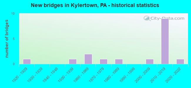
- New bridges - historical statistics
- 11920-1929
- 11950-1959
- 21960-1969
- 11970-1979
- 11980-1989
- 12000-2009
- 92010-2019
- 12020-2022


- Bridge Condition - Deck
- 36.4%Very good
- 27.3%Good
- 9.1%Satisfactory
- 27.3%Fair

- Bridge Condition - Superstructure
- 63.6%Very good
- 9.1%Good
- 27.3%Fair

- Bridge Condition - Substructure
- 45.5%Very good
- 18.2%Good
- 9.1%Satisfactory
- 27.3%Fair

- Bridge Condition - Channel
- 14.3%Very good
- 14.3%Good
- 42.9%Satisfactory
- 28.6%Fair
Find on map >> Show street view
Structure Number: 9791, Location: 1 MI S WINBURNE (Lat: 40.944522, Lng: -78.136039), Route carried "on" structure: State highway , Year Built: 1924, Status: Open, Structure Length: 0.76m (2.49ft), Average Daily Traffic: 346 (year 2022), Truck Traffic: 3%, Average Future Daily Traffic: 366 (year 2041), Design Load: H 15, Features Intersected: BLACK BEAR RUN, Facility Carried by Structure: ON TSR 958
Minimum Vertical Clearance: 30+ m (98+ ft), Kilometerpoint: 0.055, Lanes on structure: 1, Owner: State Highway Agency, Approaching Roadway Width: 5.5m (18.0ft), Material/Design: Steel, Design/Construction: Stringer/Multi-beam, Number Of Spans In Main Unit: 1, Length of Maximum Span: 7.0m (23.0ft), Curb-To-Curb Width: 4.9m (16.1ft), Out-to-Out Width: 5.5m (18.0ft)
Condition: Deck: Fair, Superstructure: Fair, Substructure: Fair, Channel: Fair, Operating Rating: 78.9 metric tons, Method Used To Determine Operating Rating: Field evaluation and documented engineering judgment, Inventory Rating: 47.2 metric tons, Method Used To Determine Inventory Rating: Field evaluation and documented engineering judgment, Structural Evaluation: Somewhat better than minimum adequacy, Deck Geometry: High priority of replacement, Waterway Adequacy: Better than present minimum criteria, Approach Roadway Alignment: Meets minimum limits, Length Of Structure Improvement: 0.80m (2.62ft), Designated Inspection Frequency: Every 24 months, Inspection Date: July 2021, Bridge Improvement Cost: $30,000, Roadway Improvement Cost: $218,000, Total Project Cost: $403,000, Deck Structure Type: Concrete Cast-file-Place, Wearing Surface/Protective System: Wearing Surface: Bituminous
Find on map >> Show street view
Structure Number: 9794, Location: WINBURNE (Lat: 40.956319, Lng: -78.139719), Route carried "on" structure: Spur State highway , Year Built: 1952, Status: Open, Structure Length: 3.47m (11.38ft), Average Daily Traffic: 386 (year 2022), Truck Traffic: 9%, Average Future Daily Traffic: 541 (year 2041), Design Load: HS 20, Features Intersected: MOSHANNON CREEK, Facility Carried by Structure: ON TSR 959
Minimum Vertical Clearance: 30+ m (98+ ft), Kilometerpoint: 0.000, Lanes on structure: 2, Owner: State Highway Agency, Approaching Roadway Width: 5.8m (19.0ft), Material/Design: Concrete, Design/Construction: Tee Beam, Number Of Spans In Main Unit: 2, Length of Maximum Span: 17.1m (56.1ft), Curb-To-Curb Width: 6.0m (19.7ft), Out-to-Out Width: 7.3m (24.0ft)
Condition: Deck: Fair, Superstructure: Fair, Substructure: Fair, Channel: Satisfactory, Operating Rating: 65.3 metric tons, Method Used To Determine Operating Rating: Field evaluation and documented engineering judgment, Inventory Rating: 39.0 metric tons, Method Used To Determine Inventory Rating: Field evaluation and documented engineering judgment, Structural Evaluation: Somewhat better than minimum adequacy, Deck Geometry: High priority of corrective action, Waterway Adequacy: Better than present minimum criteria, Approach Roadway Alignment: Somewhat better than minimum adequacy, Length Of Structure Improvement: 3.50m (11.48ft), Designated Inspection Frequency: Every 24 months, Inspection Date: July 2021, Bridge Improvement Cost: $46,000, Roadway Improvement Cost: $250,000, Total Project Cost: $618,000, Deck Structure Type: Concrete Cast-file-Place, Wearing Surface/Protective System: Wearing Surface: Bituminous
Find on map >> Show street view
Structure Number: 11667, Location: 6 MI N KYLERTOWN (Lat: 41.057336, Lng: -78.156983), Route carried "on" structure: State highway , Year Built: 1971, Status: Open, Structure Length: 15.88m (52.10ft), Average Daily Traffic: 1,046 (year 2022), Truck Traffic: 6%, Average Future Daily Traffic: 829 (year 2041), Design Load: HS 20, Features Intersected: R J CORMAN/W BR SUSQ R, Facility Carried by Structure: SR 1011
Minimum Vertical Clearance: 30+ m (98+ ft), Kilometerpoint: 8.404, Lanes on structure: 2, Owner: State Highway Agency, Approaching Roadway Width: 9.4m (30.8ft), Material/Design: Steel continuous, Design/Construction: Stringer/Multi-beam, Number Of Spans In Main Unit: 4, Length of Maximum Span: 44.8m (147.0ft), Curb or Sidewalk Widths: Left: 0.2m (0.7ft), Right: 0.2m (0.7ft), Curb-To-Curb Width: 12.8m (42.0ft), Out-to-Out Width: 14.1m (46.3ft)
Condition: Deck: Fair, Superstructure: Fair, Substructure: Fair, Channel: Fair, Operating Rating: 61.7 metric tons, Method Used To Determine Operating Rating: Load Factor (LF), Inventory Rating: 36.3 metric tons, Method Used To Determine Inventory Rating: Load Factor (LF), Structural Evaluation: Somewhat better than minimum adequacy, Deck Geometry: Better than present minimum criteria, Underclear: High priority of corrective action, Waterway Adequacy: Superior to present desirable criteria, Approach Roadway Alignment: Equal to present desirable criteria, Length Of Structure Improvement: 15.90m (52.17ft), Designated Inspection Frequency: Every 24 months, Underwater Inspection Frequency: Every 60 months, Inspection Date: May 2021, Underwater Inspection Date: August 2020, Bridge Improvement Cost: $195,000, Roadway Improvement Cost: $574,000, Total Project Cost: $2,633,000, Deck Structure Type: Concrete Cast-file-Place, Wearing Surface/Protective System: Wearing Surface: Latex Concrete
Find on map >> Show street view
Structure Number: 12166, Location: MILL HALL (Lat: 41.113181, Lng: -77.487175), Route carried "on" structure: State highway 150, Year Built: 1985, Status: Open, Structure Length: 7.62m (25.00ft), Average Daily Traffic: 11,305 (year 2021), Truck Traffic: 9%, Average Future Daily Traffic: 19,510 (year 2041), Design Load: HS 20, Features Intersected: FISHING CREEK
Minimum Vertical Clearance: 30+ m (98+ ft), Kilometerpoint: 9.902, Lanes on structure: 3, Owner: State Highway Agency, Approaching Roadway Width: 15.8m (51.8ft), Skew: 2 degrees, Material/Design: Prestressed concrete, Design/Construction: Box Beam or Girders - Multiple, Number Of Spans In Main Unit: 3, Length of Maximum Span: 25.3m (83.0ft), Curb or Sidewalk Widths: Left: 0.2m (0.7ft), Right: 0.2m (0.7ft), Curb-To-Curb Width: 15.8m (51.8ft), Out-to-Out Width: 16.9m (55.4ft)
Condition: Deck: Good, Superstructure: Good, Substructure: Satisfactory, Channel: Satisfactory, Inventory Rating: 49.9 metric tons, Method Used To Determine Inventory Rating: Load Factor (LF), Structural Evaluation: Equal to present minimum criteria, Deck Geometry: Better than present minimum criteria, Waterway Adequacy: Superior to present desirable criteria, Approach Roadway Alignment: Equal to present desirable criteria, Length Of Structure Improvement: 7.60m (24.93ft), Designated Inspection Frequency: Every 24 months, Inspection Date: May 2021, Deck Structure Type: Concrete Cast-file-Place, Wearing Surface/Protective System: Wearing Surface: Epoxy Overlay, Deck Protection: Epoxy Coated Reinforcing
Find on map >> Show street view
Structure Number: 41389, Location: 2 MI NW KYLERTOWN (Lat: 41.013836, Lng: -78.199761), Route carried "on" structure: State highway , Year Built: 2001, Status: Open, Structure Length: 1.04m (3.41ft), Average Daily Traffic: 298 (year 2021), Truck Traffic: 3%, Average Future Daily Traffic: 249 (year 2041), Design Load: H 20, Features Intersected: ALDER RUN, Facility Carried by Structure: SR 1014
Minimum Vertical Clearance: 30+ m (98+ ft), Kilometerpoint: 0.000, Lanes on structure: 2, Owner: State Highway Agency, Approaching Roadway Width: 6.1m (20.0ft), Skew: 1 degrees, Material/Design: Prestressed concrete, Design/Construction: Box Beam or Girders - Single/Spread, Number Of Spans In Main Unit: 1, Length of Maximum Span: 9.4m (30.8ft), Curb or Sidewalk Widths: Left: 0.2m (0.7ft), Right: 0.2m (0.7ft), Curb-To-Curb Width: 8.7m (28.5ft), Out-to-Out Width: 9.6m (31.5ft)
Condition: Deck: Satisfactory, Superstructure: Very good, Substructure: Good, Channel: Satisfactory, Inventory Rating: 53.5 metric tons, Method Used To Determine Inventory Rating: Load Factor (LF), Structural Evaluation: Better than present minimum criteria, Deck Geometry: Equal to present minimum criteria, Waterway Adequacy: Superior to present desirable criteria, Approach Roadway Alignment: Better than present minimum criteria, Length Of Structure Improvement: 1.70m (5.58ft), Designated Inspection Frequency: Every 24 months, Inspection Date: June 2021, Deck Structure Type: Concrete Cast-file-Place, Wearing Surface/Protective System: Wearing Surface: Monolithic Concrete, Deck Protection: Epoxy Coated Reinforcing
Find on map >> Show street view
Structure Number: 46949, Location: ONE-HALF MILE E EXIT 133 (Lat: 40.989753, Lng: -78.160933), Route carried "on" structure: Interstate 80, Year Built: 2011, Status: Open, Structure Length: 2.59m (8.50ft), Average Daily Traffic: 9,471 (year 2021), Truck Traffic: 91%, Average Future Daily Traffic: 12,806 (year 2041), Design Load: HL 93, Features Intersected: SR 2037, Facility Carried by Structure: LR 1009 WB
Minimum Vertical Clearance: 30+ m (98+ ft), Kilometerpoint: 59.345, Lanes on structure: 2, Lanes under structure: 2, Base Highway Network: Yes, Owner: State Highway Agency, Approaching Roadway Width: 12.8m (42.0ft), Skew: 10 degrees, Material/Design: Prestressed concrete, Design/Construction: Box Beam or Girders - Single/Spread, Number Of Spans In Main Unit: 1, Length of Maximum Span: 25.9m (85.0ft), Curb or Sidewalk Widths: Left: 0.2m (0.7ft), Right: 0.2m (0.7ft), Curb-To-Curb Width: 12.8m (42.0ft), Out-to-Out Width: 14.0m (45.9ft)
Condition: Deck: Very good, Superstructure: Very good, Substructure: Very good, Operating Rating: 75.2 metric tons, Method Used To Determine Operating Rating: Assigned ratings based on Load and Resistance Factor Design (LRFD) reported by rating factor (RF) using HL93 loadings, Inventory Rating: 39.5 metric tons, Method Used To Determine Inventory Rating: Assigned ratings based on Load and Resistance Factor Design (LRFD) reported by rating factor (RF) using HL93 loadings, Structural Evaluation: Equal to present desirable criteria, Deck Geometry: Equal to present desirable criteria, Underclear: Meets minimum limits, Approach Roadway Alignment: Equal to present desirable criteria, Designated Inspection Frequency: Every 24 months, Inspection Date: July 2021, Deck Structure Type: Concrete Cast-file-Place, Wearing Surface/Protective System: Wearing Surface: Epoxy Overlay, Deck Protection: Epoxy Coated Reinforcing
Find on map >> Show street view
Structure Number: 4695, Location: EXIT 133 KYLERTOWN INTER (Lat: 40.988692, Lng: -78.168533), Route carried "on" structure: Interstate 80, Year Built: 2011, Status: Open, Structure Length: 8.17m (26.80ft), Average Daily Traffic: 9,471 (year 2021), Truck Traffic: 91%, Average Future Daily Traffic: 12,806 (year 2041), Design Load: HL 93, Features Intersected: SR 53
Minimum Vertical Clearance: 30+ m (98+ ft), Kilometerpoint: 58.567, Lanes on structure: 2, Lanes under structure: 2, Base Highway Network: Yes, Owner: State Highway Agency, Approaching Roadway Width: 12.8m (42.0ft), Skew: 5 degrees, Material/Design: Steel continuous, Design/Construction: Stringer/Multi-beam, Number Of Spans In Main Unit: 3, Length of Maximum Span: 34.4m (112.9ft), Curb or Sidewalk Widths: Left: 0.2m (0.7ft), Right: 0.2m (0.7ft), Curb-To-Curb Width: 12.8m (42.0ft), Out-to-Out Width: 13.8m (45.3ft)
Condition: Deck: Good, Superstructure: Very good, Substructure: Very good, Operating Rating: 67.7 metric tons, Method Used To Determine Operating Rating: Assigned ratings based on Load and Resistance Factor Design (LRFD) reported by rating factor (RF) using HL93 loadings, Inventory Rating: 42.4 metric tons, Method Used To Determine Inventory Rating: Assigned ratings based on Load and Resistance Factor Design (LRFD) reported by rating factor (RF) using HL93 loadings, Structural Evaluation: Equal to present desirable criteria, Deck Geometry: Equal to present desirable criteria, Underclear: Superior to present desirable criteria, Approach Roadway Alignment: Equal to present desirable criteria, Designated Inspection Frequency: Every 24 months, Inspection Date: July 2021, Deck Structure Type: Concrete Cast-file-Place, Wearing Surface/Protective System: Wearing Surface: Epoxy Overlay, Deck Protection: Epoxy Coated Reinforcing
Find on map >> Show street view
Structure Number: 47503, Location: ONE-HALF MI E EXIT 133 (Lat: 40.987264, Lng: -78.159689), Route carried "on" structure: Interstate 80, Year Built: 2012, Status: Open, Structure Length: 2.59m (8.50ft), Average Daily Traffic: 10,340 (year 2021), Truck Traffic: 88%, Average Future Daily Traffic: 12,965 (year 2041), Design Load: HL 93, Features Intersected: SR 2037
Minimum Vertical Clearance: 30+ m (98+ ft), Kilometerpoint: 59.174, Lanes on structure: 2, Lanes under structure: 2, Base Highway Network: Yes, Owner: State Highway Agency, Approaching Roadway Width: 11.6m (38.1ft), Skew: 13 degrees, Material/Design: Prestressed concrete, Design/Construction: Box Beam or Girders - Single/Spread, Number Of Spans In Main Unit: 1, Length of Maximum Span: 25.9m (85.0ft), Curb or Sidewalk Widths: Left: 0.2m (0.7ft), Right: 0.2m (0.7ft), Curb-To-Curb Width: 13.0m (42.7ft), Out-to-Out Width: 14.1m (46.3ft)
Condition: Deck: Very good, Superstructure: Very good, Substructure: Very good, Operating Rating: 75.2 metric tons, Method Used To Determine Operating Rating: Assigned ratings based on Load and Resistance Factor Design (LRFD) reported by rating factor (RF) using HL93 loadings, Inventory Rating: 40.2 metric tons, Method Used To Determine Inventory Rating: Assigned ratings based on Load and Resistance Factor Design (LRFD) reported by rating factor (RF) using HL93 loadings, Structural Evaluation: Equal to present desirable criteria, Deck Geometry: Superior to present desirable criteria, Underclear: Meets minimum limits, Approach Roadway Alignment: Equal to present desirable criteria, Designated Inspection Frequency: Every 24 months, Inspection Date: July 2021, Deck Structure Type: Concrete Cast-file-Place, Wearing Surface/Protective System: Wearing Surface: Epoxy Overlay, Deck Protection: Epoxy Coated Reinforcing
Find on map >> Show street view
Structure Number: 47508, Location: EXIT 133 KYLERTOWN INTER (Lat: 40.986561, Lng: -78.171281), Route carried "on" structure: Interstate 80, Year Built: 2012, Status: Open, Structure Length: 6.71m (22.01ft), Average Daily Traffic: 10,340 (year 2021), Truck Traffic: 88%, Average Future Daily Traffic: 12,965 (year 2041), Design Load: HL 93, Features Intersected: SR 53 - PA 53
Minimum Vertical Clearance: 30+ m (98+ ft), Kilometerpoint: 58.344, Lanes on structure: 2, Lanes under structure: 2, Base Highway Network: Yes, Owner: State Highway Agency, Approaching Roadway Width: 11.6m (38.1ft), Skew: 15 degrees, Material/Design: Steel continuous, Design/Construction: Stringer/Multi-beam, Number Of Spans In Main Unit: 3, Length of Maximum Span: 28.3m (92.8ft), Curb or Sidewalk Widths: Left: 0.2m (0.7ft), Right: 0.2m (0.7ft), Curb-To-Curb Width: 12.8m (42.0ft), Out-to-Out Width: 13.8m (45.3ft)
Condition: Deck: Good, Superstructure: Very good, Substructure: Very good, Operating Rating: 68.4 metric tons, Method Used To Determine Operating Rating: Assigned ratings based on Load and Resistance Factor Design (LRFD) reported by rating factor (RF) using HL93 loadings, Inventory Rating: 42.8 metric tons, Method Used To Determine Inventory Rating: Assigned ratings based on Load and Resistance Factor Design (LRFD) reported by rating factor (RF) using HL93 loadings, Structural Evaluation: Equal to present desirable criteria, Deck Geometry: Equal to present desirable criteria, Underclear: Better than present minimum criteria, Approach Roadway Alignment: Equal to present desirable criteria, Designated Inspection Frequency: Every 24 months, Inspection Date: July 2021, Deck Structure Type: Concrete Cast-file-Place, Wearing Surface/Protective System: Wearing Surface: Epoxy Overlay, Deck Protection: Epoxy Coated Reinforcing
Find on map >> Show street view
Structure Number: 5272, Location: VILLAGE OF WINBURNE (Lat: 40.966133, Lng: -78.145642), Route carried "on" structure: State highway , Year Built: 2015, Status: Open, Structure Length: 0.85m (2.79ft), Average Daily Traffic: 412 (year 2022), Truck Traffic: 10%, Average Future Daily Traffic: 563 (year 2041), Design Load: HL 93, Features Intersected: SULPHUR RUN, Facility Carried by Structure: SR 2035
Minimum Vertical Clearance: 30+ m (98+ ft), Kilometerpoint: 6.825, Lanes on structure: 2, Owner: State Highway Agency, Approaching Roadway Width: 6.7m (22.0ft), Skew: 1 degrees, Material/Design: Prestressed concrete, Design/Construction: Slab, Number Of Spans In Main Unit: 1, Length of Maximum Span: 7.9m (25.9ft), Curb or Sidewalk Widths: Left: 0.2m (0.7ft), Right: 0.2m (0.7ft), Curb-To-Curb Width: 8.8m (28.9ft), Out-to-Out Width: 9.9m (32.5ft)
Condition: Deck: Very good, Superstructure: Very good, Substructure: Good, Channel: Good, Operating Rating: 62.9 metric tons, Method Used To Determine Operating Rating: Assigned ratings based on Load and Resistance Factor Design (LRFD) reported by rating factor (RF) using HL93 loadings, Inventory Rating: 38.6 metric tons, Method Used To Determine Inventory Rating: Assigned ratings based on Load and Resistance Factor Design (LRFD) reported by rating factor (RF) using HL93 loadings, Structural Evaluation: Better than present minimum criteria, Deck Geometry: Somewhat better than minimum adequacy, Waterway Adequacy: Equal to present desirable criteria, Approach Roadway Alignment: Somewhat better than minimum adequacy, Designated Inspection Frequency: Every 24 months, Inspection Date: May 2021, Deck Structure Type: Concrete Cast-file-Place, Wearing Surface/Protective System: Wearing Surface: Monolithic Concrete, Deck Protection: Epoxy Coated Reinforcing
Find on map >> Show street view
Structure Number: 67808, Location: 2 MI SE WINBURNE (Lat: 40.944472, Lng: -78.136278), Route carried "on" structure: State highway , Year Built: 2020, Status: Open, Structure Length: 1.55m (5.09ft), Average Daily Traffic: 346 (year 2022), Truck Traffic: 3%, Average Future Daily Traffic: 500 (year 2041), Design Load: HL 93, Features Intersected: SIX MILE RUN, Facility Carried by Structure: ON TSR 958
Minimum Vertical Clearance: 30+ m (98+ ft), Kilometerpoint: 0.063, Lanes on structure: 2, Owner: State Highway Agency, Approaching Roadway Width: 5.5m (18.0ft), Material/Design: Prestressed concrete, Design/Construction: Box Beam or Girders - Single/Spread, Number Of Spans In Main Unit: 1, Length of Maximum Span: 14.6m (47.9ft), Curb or Sidewalk Widths: Left: 0.2m (0.7ft), Right: 0.2m (0.7ft), Curb-To-Curb Width: 6.7m (22.0ft), Out-to-Out Width: 7.7m (25.3ft)
Condition: Deck: Very good, Superstructure: Very good, Substructure: Very good, Channel: Very good, Operating Rating: 47.3 metric tons, Method Used To Determine Operating Rating: Assigned ratings based on Load and Resistance Factor Design (LRFD) reported by rating factor (RF) using HL93 loadings, Inventory Rating: 33.4 metric tons, Method Used To Determine Inventory Rating: Assigned ratings based on Load and Resistance Factor Design (LRFD) reported by rating factor (RF) using HL93 loadings, Structural Evaluation: Equal to present desirable criteria, Deck Geometry: Meets minimum limits, Waterway Adequacy: Better than present minimum criteria, Approach Roadway Alignment: Meets minimum limits, Designated Inspection Frequency: Every 24 months, Inspection Date: July 2021, Deck Structure Type: Concrete Cast-file-Place, Wearing Surface/Protective System: Wearing Surface: Monolithic Concrete, Deck Protection: Epoxy Coated Reinforcing
Find on map >> Show street view
Structure Number: 11328, Location: 2 MI E EXIT 133 (Lat: 40.982139, Lng: -78.143042), Route carried "under" structure: Interstate 80, Year Built: 1968, Structure Length: 0. m, Average Daily Traffic: 10,340 (year 2021), Truck Traffic: 88%, Features Intersected: SR 80-I 80, Facility Carried by Structure: ON TSR 711
Minimum Vertical Clearance: 5.03m (16.50ft), Kilometerpoint: 60.785, Lanes on structure: 2, Lanes under structure: 2, Material/Design: Prestressed concrete, Design/Construction: Box Beam or Girders - Single/Spread, Length of Maximum Span: 18.3m (60.0ft)
Find on map >> Show street view
Structure Number: 11329, Location: 2 MI E EXIT 133 (Lat: 40.982931, Lng: -78.142733), Route carried "under" structure: Interstate 80, Year Built: 1968, Structure Length: 0. m, Average Daily Traffic: 9,471 (year 2021), Truck Traffic: 91%, Features Intersected: SR 80-I 80, Facility Carried by Structure: ON TSR 711
Minimum Vertical Clearance: 5.09m (16.70ft), Kilometerpoint: 61.084, Lanes on structure: 2, Lanes under structure: 2, Material/Design: Prestressed concrete, Design/Construction: Box Beam or Girders - Single/Spread, Length of Maximum Span: 18.3m (60.0ft)
Find on map >> Show street view
Structure Number: 46949, Location: ONE-HALF MILE E EXIT 133 (Lat: 40.989753, Lng: -78.160933), Route carried "under" structure: State highway , Year Built: 2011, Structure Length: 0. m, Average Daily Traffic: 787 (year 2021), Truck Traffic: 7%, Features Intersected: SR 2037, Facility Carried by Structure: LR 1009 WB
Minimum Vertical Clearance: 4.61m (15.12ft), Kilometerpoint: 3.867, Lanes on structure: 2, Lanes under structure: 2, Material/Design: Prestressed concrete, Design/Construction: Box Beam or Girders - Single/Spread, Length of Maximum Span: 25.9m (85.0ft)
Find on map >> Show street view
Structure Number: 4695, Location: EXIT 133 KYLERTOWN INTER (Lat: 40.988692, Lng: -78.168533), Route carried "under" structure: State highway 53, Year Built: 2011, Structure Length: 0. m, Average Daily Traffic: 5,142 (year 2022), Truck Traffic: 5%, Features Intersected: SR 53, Facility Carried by Structure: SR 80 - I 80
Minimum Vertical Clearance: 5.39m (17.68ft), Kilometerpoint: 55.849, Lanes on structure: 2, Lanes under structure: 2, Material/Design: Steel continuous, Design/Construction: Stringer/Multi-beam, Length of Maximum Span: 34.4m (112.9ft)
Find on map >> Show street view
Structure Number: 47503, Location: ONE-HALF MI E EXIT 133 (Lat: 40.987264, Lng: -78.159689), Route carried "under" structure: State highway , Year Built: 2012, Structure Length: 0. m, Average Daily Traffic: 787 (year 2021), Truck Traffic: 7%, Features Intersected: SR 2037, Facility Carried by Structure: SR 80-I 80
Minimum Vertical Clearance: 4.51m (14.80ft), Kilometerpoint: 3.312, Lanes on structure: 2, Lanes under structure: 2, Material/Design: Prestressed concrete, Design/Construction: Box Beam or Girders - Single/Spread, Length of Maximum Span: 25.9m (85.0ft)
Find on map >> Show street view
Structure Number: 47508, Location: EXIT 133 KYLERTOWN INTER (Lat: 40.986561, Lng: -78.171281), Route carried "under" structure: State highway 53, Year Built: 2012, Structure Length: 0. m, Average Daily Traffic: 5,142 (year 2022), Truck Traffic: 5%, Features Intersected: SR 53 - PA 53, Facility Carried by Structure: SR 80 - I 80
Minimum Vertical Clearance: 5.11m (16.77ft), Kilometerpoint: 55.849, Lanes on structure: 2, Lanes under structure: 2, Material/Design: Steel continuous, Design/Construction: Stringer/Multi-beam, Length of Maximum Span: 28.3m (92.8ft)