Bridge Statistics for Kutztown University, Pennsylvania (PA)
Condition, Traffic, Stress, Structural Evaluation, Project Costs
- National Bridge Inventory (NBI) Statistics
- 10Number of bridges
- 79ft / 24.1mTotal length
- $2,573,000Total costs
- 78,046Total average daily traffic
- 12,665Total average daily truck traffic
- National Bridge Inventory (NBI) Registered Bridges for Kutztown University
- No street view available for this location
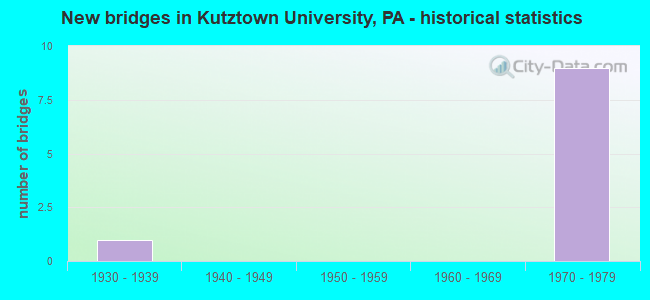
- New bridges - historical statistics
- 11930-1939
- 91970-1979

- Reconstructed bridges - Historical Statistics
- 22000-2009
- 12010-2019


- Bridge Condition - Deck
- 80.0%Good
- 20.0%Fair

- Bridge Condition - Superstructure
- 40.0%Good
- 60.0%Fair

- Bridge Condition - Substructure
- 60.0%Good
- 20.0%Satisfactory
- 20.0%Fair

- Bridge Condition - Channel
- 50.0%Good
- 50.0%Poor
Find on map >> Show street view
Structure Number: 4797, Location: S.END OF KUTZTOWN BYPASS (Lat: 40.500167, Lng: -75.807806), Route carried "on" structure: US 222, Year Built: 1934, Status: Open, Structure Length: 1.22m (4.00ft), Average Daily Traffic: 27,221 (year 2022), Truck Traffic: 11%, Average Future Daily Traffic: 31,347 (year 2032), Design Load: HS 20, Features Intersected: TRIB.TO MOSELEM CREEK
Minimum Vertical Clearance: 30+ m (98+ ft), Kilometerpoint: 39.009, Lanes on structure: 3, Base Highway Network: Yes, Owner: State Highway Agency, Approaching Roadway Width: 15.2m (49.9ft), Skew: 3 degrees, Material/Design: Concrete, Design/Construction: Tee Beam, Number Of Spans In Main Unit: 1, Length of Maximum Span: 11.6m (38.1ft), Curb-To-Curb Width: 15.3m (50.2ft), Out-to-Out Width: 16.0m (52.5ft)
Condition: Deck: Fair, Superstructure: Fair, Substructure: Fair, Channel: Poor, Operating Rating: 43.5 metric tons, Method Used To Determine Operating Rating: Load Factor (LF), Inventory Rating: 25.4 metric tons, Method Used To Determine Inventory Rating: Load Factor (LF), Structural Evaluation: Somewhat better than minimum adequacy, Deck Geometry: Equal to present minimum criteria, Waterway Adequacy: Equal to present minimum criteria, Approach Roadway Alignment: Equal to present desirable criteria, Length Of Structure Improvement: 1.90m (6.23ft), Designated Inspection Frequency: Every 24 months, Underwater Inspection Frequency: Every 24 months, Inspection Date: January 2021, Underwater Inspection Date: September 2021, Bridge Improvement Cost: $82,000, Roadway Improvement Cost: $242,000, Total Project Cost: $1,109,000, Deck Structure Type: Concrete Cast-file-Place, Wearing Surface/Protective System: Wearing Surface: Bituminous
Find on map >> Show street view
Structure Number: 48, Location: 2 MI.S.OF KUTZTOWN (Lat: 40.507556, Lng: -75.801961), Route carried "on" structure: US 222, Year Built: 1972, Year Reconstructed: 2011, Status: Open, Structure Length: 4.94m (16.21ft), Average Daily Traffic: 10,579 (year 2020), Truck Traffic: 22%, Average Future Daily Traffic: 13,967 (year 2032), Design Load: HL 93, Features Intersected: SR 8009SB ON RAMP TO 222
Minimum Vertical Clearance: 30+ m (98+ ft), Kilometerpoint: 39.867, Lanes on structure: 2, Lanes under structure: 1, Base Highway Network: Yes, Owner: State Highway Agency, Approaching Roadway Width: 12.2m (40.0ft), Skew: 11 degrees, Material/Design: Prestressed concrete, Design/Construction: Stringer/Multi-beam, Number Of Spans In Main Unit: 3, Length of Maximum Span: 24.1m (79.1ft), Curb-To-Curb Width: 11.9m (39.0ft), Out-to-Out Width: 13.2m (43.3ft)
Condition: Deck: Good, Superstructure: Good, Substructure: Good, Operating Rating: 53.5 metric tons, Method Used To Determine Operating Rating: Assigned ratings based on Load and Resistance Factor Design (LRFD) reported in metric tons, Inventory Rating: 25.4 metric tons, Method Used To Determine Inventory Rating: Assigned ratings based on Load and Resistance Factor Design (LRFD) reported in metric tons, Structural Evaluation: Equal to present minimum criteria, Deck Geometry: Better than present minimum criteria, Underclear: Equal to present minimum criteria, Approach Roadway Alignment: Equal to present desirable criteria, Length Of Structure Improvement: 5.90m (19.36ft), Designated Inspection Frequency: Every 24 months, Inspection Date: January 2020, Deck Structure Type: Concrete Cast-file-Place, Wearing Surface/Protective System: Wearing Surface: Latex Concrete
Find on map >> Show street view
Structure Number: 4811, Location: NORTH END OF BY-PASS (Lat: 40.497311, Lng: -75.809097), Route carried "on" structure: US 222, Year Built: 1972, Year Reconstructed: 2011, Status: Open, Structure Length: 6.74m (22.11ft), Average Daily Traffic: 9,731 (year 2020), Truck Traffic: 22%, Average Future Daily Traffic: 13,969 (year 2032), Design Load: HS 20, Features Intersected: SR 8015(RAMP G)
Minimum Vertical Clearance: 30+ m (98+ ft), Kilometerpoint: 46.132, Lanes on structure: 2, Lanes under structure: 1, Base Highway Network: Yes, Owner: State Highway Agency, Approaching Roadway Width: 12.2m (40.0ft), Skew: 14 degrees, Material/Design: Steel, Design/Construction: Stringer/Multi-beam, Number Of Spans In Main Unit: 1, Number Of Approach Spans: 2, Length of Maximum Span: 32.6m (107.0ft), Curb-To-Curb Width: 11.9m (39.0ft), Out-to-Out Width: 13.2m (43.3ft)
Condition: Deck: Good, Superstructure: Fair, Substructure: Satisfactory, Operating Rating: 81.6 metric tons, Method Used To Determine Operating Rating: Load Factor (LF), Inventory Rating: 49.0 metric tons, Method Used To Determine Inventory Rating: Load Factor (LF), Structural Evaluation: Somewhat better than minimum adequacy, Deck Geometry: Better than present minimum criteria, Underclear: Equal to present minimum criteria, Approach Roadway Alignment: Equal to present desirable criteria, Length Of Structure Improvement: 7.70m (25.26ft), Designated Inspection Frequency: Every 24 months, Inspection Date: Febuary 2020, Bridge Improvement Cost: $23,000, Roadway Improvement Cost: $69,000, Total Project Cost: $315,000, Deck Structure Type: Concrete Cast-file-Place, Wearing Surface/Protective System: Wearing Surface: Latex Concrete
Find on map >> Show street view
Structure Number: 4955, Location: US 222 INTERCHANGE (Lat: 40.504575, Lng: -75.805053), Route carried "on" structure: State highway , Year Built: 1972, Year Reconstructed: 2010, Status: Open, Structure Length: 9.63m (31.59ft), Average Daily Traffic: 2,377 (year 2022), Truck Traffic: 12%, Average Future Daily Traffic: 3,029 (year 2032), Design Load: HS 20, Features Intersected: US 0222(LR 157), Facility Carried by Structure: SR 1006 (LR 06139)
Minimum Vertical Clearance: 30+ m (98+ ft), Kilometerpoint: 7.100, Lanes on structure: 2, Lanes under structure: 4, Owner: State Highway Agency, Approaching Roadway Width: 13.4m (44.0ft), Skew: 2 degrees, Material/Design: Steel continuous, Design/Construction: Stringer/Multi-beam, Number Of Spans In Main Unit: 2, Number Of Approach Spans: 2, Length of Maximum Span: 34.4m (112.9ft), Curb-To-Curb Width: 13.4m (44.0ft), Out-to-Out Width: 14.6m (47.9ft)
Condition: Deck: Good, Superstructure: Fair, Substructure: Good, Operating Rating: 59.0 metric tons, Method Used To Determine Operating Rating: Load Factor (LF), Inventory Rating: 35.4 metric tons, Method Used To Determine Inventory Rating: Load Factor (LF), Structural Evaluation: Somewhat better than minimum adequacy, Deck Geometry: Better than present minimum criteria, Underclear: Equal to present minimum criteria, Approach Roadway Alignment: Equal to present desirable criteria, Length Of Structure Improvement: 10.60m (34.78ft), Designated Inspection Frequency: Every 24 months, Inspection Date: May 2020, Bridge Improvement Cost: $85,000, Roadway Improvement Cost: $251,000, Total Project Cost: $1,149,000, Deck Structure Type: Concrete Cast-file-Place, Wearing Surface/Protective System: Wearing Surface: Latex Concrete
Find on map >> Show street view
Structure Number: 544, Location: 200 FT. S.OF RT.222 (Lat: 40.493236, Lng: -75.816358), Route carried "on" structure: City street , Year Built: 1970, Status: Open, Structure Length: 1.62m (5.31ft), Average Daily Traffic: 200 (year 2009), Truck Traffic: 1%, Average Future Daily Traffic: 230 (year 2019), Design Load: HS 20, Features Intersected: TRIB.TO MOSELEM CREEK, Facility Carried by Structure: SCHULER ROAD
Minimum Vertical Clearance: 30+ m (98+ ft), Kilometerpoint: 0.000, Lanes on structure: 2, Owner: Town or Township Highway Agency, Approaching Roadway Width: 6.4m (21.0ft), Skew: 1 degrees, Material/Design: Prestressed concrete, Design/Construction: Box Beam or Girders - Single/Spread, Number Of Spans In Main Unit: 1, Length of Maximum Span: 16.2m (53.1ft), Curb or Sidewalk Widths: Left: 0.2m (0.7ft), Right: 0.2m (0.7ft), Curb-To-Curb Width: 11.0m (36.1ft), Out-to-Out Width: 12.2m (40.0ft)
Condition: Deck: Good, Superstructure: Good, Substructure: Good, Channel: Good, Operating Rating: 48.1 metric tons, Method Used To Determine Operating Rating: Load Factor (LF), Inventory Rating: 29.0 metric tons, Method Used To Determine Inventory Rating: Load Factor (LF), Structural Evaluation: Better than present minimum criteria, Deck Geometry: Equal to present desirable criteria, Waterway Adequacy: Superior to present desirable criteria, Approach Roadway Alignment: Equal to present desirable criteria, Designated Inspection Frequency: Every 24 months, Inspection Date: June 2020, Deck Structure Type: Concrete Cast-file-Place, Wearing Surface/Protective System: Wearing Surface: Monolithic Concrete
Find on map >> Show street view
Structure Number: 4799, Location: 2 MI S OF KUTZTOWN (Lat: 40.508000, Lng: -75.800633), Route carried "under" structure: Ramp State highway , Year Built: 1972, Structure Length: 0. m, Average Daily Traffic: 2,162 (year 2022), Truck Traffic: 7%, Features Intersected: SR 8009SB ON RAMP TO 222, Facility Carried by Structure: US 222NB(LR 157)
Minimum Vertical Clearance: 4.85m (15.91ft), Kilometerpoint: 0.000, Lanes on structure: 2, Lanes under structure: 1, Material/Design: Prestressed concrete, Design/Construction: Stringer/Multi-beam, Length of Maximum Span: 24.4m (80.1ft)
Find on map >> Show street view
Structure Number: 48, Location: 2 MI.S.OF KUTZTOWN (Lat: 40.507556, Lng: -75.801961), Route carried "under" structure: Ramp State highway , Year Built: 1972, Structure Length: 0. m, Average Daily Traffic: 2,162 (year 2022), Truck Traffic: 7%, Features Intersected: SR 8009SB ON RAMP TO 222, Facility Carried by Structure: US 222SB(LR157)
Minimum Vertical Clearance: 4.42m (14.50ft), Kilometerpoint: 0.000, Lanes on structure: 2, Lanes under structure: 1, Material/Design: Prestressed concrete, Design/Construction: Stringer/Multi-beam, Length of Maximum Span: 24.1m (79.1ft)
Find on map >> Show street view
Structure Number: 4811, Location: NORTH END OF BY-PASS (Lat: 40.497311, Lng: -75.809097), Route carried "under" structure: Ramp State highway , Year Built: 1972, Structure Length: 0. m, Average Daily Traffic: 2,442 (year 2022), Truck Traffic: 7%, Features Intersected: SR 8015(RAMP G), Facility Carried by Structure: US 222 SB(LR 157)
Minimum Vertical Clearance: 4.45m (14.60ft), Kilometerpoint: 0.000, Lanes on structure: 2, Lanes under structure: 1, Material/Design: Steel, Design/Construction: Stringer/Multi-beam, Length of Maximum Span: 32.6m (107.0ft)
Find on map >> Show street view
Structure Number: 4955, Location: US 222 INTERCHANGE (Lat: 40.504575, Lng: -75.805053), Route carried "under" structure: US 222, Year Built: 1972, Structure Length: 0. m, Average Daily Traffic: 10,593 (year 2020), Truck Traffic: 20%, Features Intersected: US 0222(LR 157), Facility Carried by Structure: SR 1006 (LR 06139)
Minimum Vertical Clearance: 5.52m (18.11ft), Kilometerpoint: 41.013, Lanes on structure: 2, Lanes under structure: 2, Material/Design: Steel continuous, Design/Construction: Stringer/Multi-beam, Length of Maximum Span: 34.4m (112.9ft)
Find on map >> Show street view
Structure Number: 4955, Location: US 222 INTERCHANGE (Lat: 40.504575, Lng: -75.805053), Route carried "under" structure: US 222, Year Built: 1972, Structure Length: 0. m, Average Daily Traffic: 10,579 (year 2020), Truck Traffic: 22%, Features Intersected: US 0222(LR 157), Facility Carried by Structure: SR 1006 (LR 06139)
Minimum Vertical Clearance: 4.79m (15.72ft), Kilometerpoint: 41.014, Lanes on structure: 2, Lanes under structure: 2, Material/Design: Steel continuous, Design/Construction: Stringer/Multi-beam, Length of Maximum Span: 34.4m (112.9ft)