Bridge Statistics for Kohler, Wisconsin (WI)
Condition, Traffic, Stress, Structural Evaluation, Project Costs
- National Bridge Inventory (NBI) Statistics
- 20Number of bridges
- 197ft / 60.4mTotal length
- 294,234Total average daily traffic
- 10,972Total average daily truck traffic
- National Bridge Inventory (NBI) Registered Bridges for Kohler
- No street view available for this location
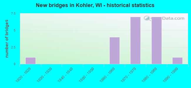
- New bridges - historical statistics
- 11920-1929
- 41960-1969
- 71970-1979
- 71980-1989
- 11990-1999


- Bridge Condition - Deck
- 66.7%Good
- 22.2%Satisfactory
- 11.1%Fair

- Bridge Condition - Superstructure
- 22.2%Very good
- 55.6%Good
- 22.2%Fair

- Bridge Condition - Substructure
- 66.7%Good
- 33.3%Satisfactory

- Bridge Condition - Channel
- 57.1%Very good
- 14.3%Good
- 14.3%Fair
- 14.3%Poor

- Bridge Condition - Culverts
- 33.3%Good
- 66.7%Satisfactory
Find on map >> Show street view
Structure Number: B590019, Location: 1.8M N JCT STH 28 TO E (Lat: 43.741147, Lng: -87.758936), Route carried "on" structure: Interstate 43, Year Built: 1967, Status: Open, Structure Length: 6.08m (19.95ft), Average Daily Traffic: 15,700 (year 2021), Truck Traffic: 20%, Average Future Daily Traffic: 26,650 (year 2040), Design Load: HS 20, Features Intersected: SHEBOYGAN RIVER
Minimum Vertical Clearance: 30+ m (98+ ft), Kilometerpoint: 0.000, Lanes on structure: 2, Base Highway Network: Yes, Owner: State Highway Agency, Approaching Roadway Width: 12.2m (40.0ft), Material/Design: Prestressed concrete continuous, Design/Construction: Stringer/Multi-beam, Number Of Spans In Main Unit: 3, Length of Maximum Span: 20.3m (66.6ft), Curb-To-Curb Width: 13.3m (43.6ft), Out-to-Out Width: 14.2m (46.6ft)
Condition: Deck: Good, Superstructure: Very good, Substructure: Satisfactory, Channel: Very good, Operating Rating: 58.8 metric tons, Method Used To Determine Operating Rating: Load Factor (LF), Inventory Rating: 29.2 metric tons, Method Used To Determine Inventory Rating: Load Factor (LF), Structural Evaluation: Equal to present minimum criteria, Deck Geometry: Superior to present desirable criteria, Waterway Adequacy: Equal to present desirable criteria, Approach Roadway Alignment: Equal to present desirable criteria, Designated Inspection Frequency: Every 24 months, Inspection Date: August 2021, Deck Structure Type: Concrete Cast-file-Place, Wearing Surface/Protective System: Wearing Surface: Low Slump Concrete
Find on map >> Show street view
Structure Number: B590028, Location: 3.1M N JCT CTH V TO E (Lat: 43.717422, Lng: -87.760261), Route carried "on" structure: Interstate 43, Year Built: 1984, Status: Open, Structure Length: 5.60m (18.37ft), Average Daily Traffic: 15,350 (year 2021), Truck Traffic: 1%, Average Future Daily Traffic: 23,484 (year 2040), Design Load: HS 20, Features Intersected: STH 28
Minimum Vertical Clearance: 30+ m (98+ ft), Kilometerpoint: 0.000, Lanes on structure: 2, Lanes under structure: 6, Base Highway Network: Yes, Owner: State Highway Agency, Approaching Roadway Width: 12.2m (40.0ft), Material/Design: Concrete continuous, Design/Construction: Slab, Number Of Spans In Main Unit: 4, Length of Maximum Span: 19.8m (65.0ft), Curb-To-Curb Width: 12.2m (40.0ft), Out-to-Out Width: 13.1m (43.0ft)
Condition: Deck: Good, Superstructure: Good, Substructure: Good, Operating Rating: 55.5 metric tons, Method Used To Determine Operating Rating: Load Factor (LF), Inventory Rating: 32.4 metric tons, Method Used To Determine Inventory Rating: Load Factor (LF), Structural Evaluation: Better than present minimum criteria, Deck Geometry: Better than present minimum criteria, Underclear: Equal to present minimum criteria, Approach Roadway Alignment: Equal to present desirable criteria, Designated Inspection Frequency: Every 48 months, Inspection Date: November 2021, Deck Structure Type: Concrete Cast-file-Place, Wearing Surface/Protective System: Wearing Surface: Low Slump Concrete, Deck Protection: Epoxy Coated Reinforcing
Find on map >> Show street view
Structure Number: B590053, Location: 1.6M S JCT CTH PPP (Lat: 43.717925, Lng: -87.760675), Route carried "on" structure: Interstate 43, Year Built: 1984, Status: Open, Structure Length: 5.60m (18.37ft), Average Daily Traffic: 15,500 (year 2021), Truck Traffic: 1%, Average Future Daily Traffic: 23,985 (year 2040), Design Load: HS 20, Features Intersected: STH 28
Minimum Vertical Clearance: 30+ m (98+ ft), Kilometerpoint: 0.000, Lanes on structure: 2, Lanes under structure: 6, Base Highway Network: Yes, Owner: State Highway Agency, Approaching Roadway Width: 12.2m (40.0ft), Material/Design: Concrete continuous, Design/Construction: Slab, Number Of Spans In Main Unit: 4, Length of Maximum Span: 19.8m (65.0ft), Curb-To-Curb Width: 12.2m (40.0ft), Out-to-Out Width: 13.1m (43.0ft)
Condition: Deck: Good, Superstructure: Good, Substructure: Satisfactory, Operating Rating: 55.5 metric tons, Method Used To Determine Operating Rating: Load Factor (LF), Inventory Rating: 32.4 metric tons, Method Used To Determine Inventory Rating: Load Factor (LF), Structural Evaluation: Equal to present minimum criteria, Deck Geometry: Better than present minimum criteria, Underclear: Somewhat better than minimum adequacy, Approach Roadway Alignment: Equal to present desirable criteria, Designated Inspection Frequency: Every 24 months, Inspection Date: November 2021, Deck Structure Type: Concrete Cast-file-Place, Wearing Surface/Protective System: Wearing Surface: Low Slump Concrete, Deck Protection: Epoxy Coated Reinforcing
Find on map >> Show street view
Structure Number: B590054, Location: 3.3M S JCT STH 23 TO E (Lat: 43.741583, Lng: -87.759592), Route carried "on" structure: Interstate 43, Year Built: 1971, Status: Open, Structure Length: 6.08m (19.95ft), Average Daily Traffic: 15,700 (year 2021), Truck Traffic: 20%, Average Future Daily Traffic: 26,650 (year 2040), Design Load: HS 20, Features Intersected: SHEBOYGAN RIVER
Minimum Vertical Clearance: 30+ m (98+ ft), Kilometerpoint: 0.000, Lanes on structure: 2, Base Highway Network: Yes, Owner: State Highway Agency, Approaching Roadway Width: 12.2m (40.0ft), Material/Design: Prestressed concrete continuous, Design/Construction: Stringer/Multi-beam, Number Of Spans In Main Unit: 3, Length of Maximum Span: 20.3m (66.6ft), Curb-To-Curb Width: 16.2m (53.1ft), Out-to-Out Width: 17.1m (56.1ft)
Condition: Deck: Good, Superstructure: Very good, Substructure: Satisfactory, Channel: Very good, Operating Rating: 55.5 metric tons, Method Used To Determine Operating Rating: Load Factor (LF), Inventory Rating: 27.5 metric tons, Method Used To Determine Inventory Rating: Load Factor (LF), Structural Evaluation: Equal to present minimum criteria, Deck Geometry: Superior to present desirable criteria, Waterway Adequacy: Equal to present desirable criteria, Approach Roadway Alignment: Equal to present desirable criteria, Designated Inspection Frequency: Every 24 months, Inspection Date: August 2021, Deck Structure Type: Concrete Cast-file-Place, Wearing Surface/Protective System: Wearing Surface: Low Slump Concrete
Find on map >> Show street view
Structure Number: B59008, Location: 0.5M S JCT CTH O (Lat: 43.753283, Lng: -87.779711), Route carried "on" structure: County highway , Year Built: 1977, Status: Open, Structure Length: 6.45m (21.16ft), Average Daily Traffic: 12,500 (year 2020), Average Future Daily Traffic: 2,255 (year 2039), Design Load: HS 20, Features Intersected: STH 23, Facility Carried by Structure: CTH Y
Minimum Vertical Clearance: 30+ m (98+ ft), Kilometerpoint: 0.000, Lanes on structure: 4, Lanes under structure: 5, Owner: State Highway Agency, Approaching Roadway Width: 20.1m (65.9ft), Skew: 20 degrees, Material/Design: Steel continuous, Design/Construction: Stringer/Multi-beam, Number Of Spans In Main Unit: 2, Length of Maximum Span: 33.4m (109.6ft), Curb-To-Curb Width: 18.9m (62.0ft), Out-to-Out Width: 24.9m (81.7ft)
Condition: Deck: Satisfactory, Superstructure: Good, Substructure: Good, Operating Rating: 53.9 metric tons, Method Used To Determine Operating Rating: Load Factor (LF), Inventory Rating: 32.4 metric tons, Method Used To Determine Inventory Rating: Load Factor (LF), Structural Evaluation: Better than present minimum criteria, Deck Geometry: Equal to present minimum criteria, Underclear: Somewhat better than minimum adequacy, Approach Roadway Alignment: Equal to present desirable criteria, Designated Inspection Frequency: Every 24 months, Inspection Date: July 2020, Deck Structure Type: Concrete Cast-file-Place, Wearing Surface/Protective System: Wearing Surface: Low Slump Concrete
Find on map >> Show street view
Structure Number: B590081, Location: 0.6M S JCT CTH O (Lat: 43.752428, Lng: -87.789892), Route carried "on" structure: City street , Year Built: 1977, Status: Open, Structure Length: 6.87m (22.54ft), Average Daily Traffic: 500 (year 2020), Average Future Daily Traffic: 356 (year 2039), Design Load: H 20, Features Intersected: STH 23, Facility Carried by Structure: LRD WOODLAND RD
Minimum Vertical Clearance: 30+ m (98+ ft), Kilometerpoint: 0.000, Lanes on structure: 2, Lanes under structure: 4, Owner: State Highway Agency, Approaching Roadway Width: 12.2m (40.0ft), Skew: 1 degrees, Material/Design: Steel continuous, Design/Construction: Stringer/Multi-beam, Number Of Spans In Main Unit: 2, Length of Maximum Span: 34.3m (112.5ft), Curb-To-Curb Width: 10.4m (34.1ft), Out-to-Out Width: 11.5m (37.7ft)
Condition: Deck: Good, Superstructure: Good, Substructure: Good, Operating Rating: 63.7 metric tons, Method Used To Determine Operating Rating: Load Factor (LF), Inventory Rating: 37.3 metric tons, Method Used To Determine Inventory Rating: Load Factor (LF), Structural Evaluation: Better than present minimum criteria, Deck Geometry: Equal to present minimum criteria, Underclear: Somewhat better than minimum adequacy, Approach Roadway Alignment: Equal to present desirable criteria, Designated Inspection Frequency: Every 48 months, Inspection Date: July 2020, Deck Structure Type: Concrete Cast-file-Place, Wearing Surface/Protective System: Wearing Surface: Low Slump Concrete
Find on map >> Show street view
Structure Number: B590082, Location: 0.7M S JCT CTH O (Lat: 43.750425, Lng: -87.800006), Route carried "on" structure: City street , Year Built: 1977, Status: Open, Structure Length: 6.65m (21.82ft), Average Daily Traffic: 400 (year 2020), Average Future Daily Traffic: 345 (year 2039), Design Load: H 20, Features Intersected: STH 23, Facility Carried by Structure: LRD RANGE LINE RD
Minimum Vertical Clearance: 30+ m (98+ ft), Kilometerpoint: 0.000, Lanes on structure: 2, Lanes under structure: 4, Owner: State Highway Agency, Approaching Roadway Width: 12.2m (40.0ft), Skew: 1 degrees, Material/Design: Steel continuous, Design/Construction: Stringer/Multi-beam, Number Of Spans In Main Unit: 2, Length of Maximum Span: 32.6m (107.0ft), Curb-To-Curb Width: 10.4m (34.1ft), Out-to-Out Width: 11.5m (37.7ft)
Condition: Deck: Good, Superstructure: Good, Substructure: Good, Operating Rating: 44.1 metric tons, Method Used To Determine Operating Rating: Load Factor (LF), Inventory Rating: 25.9 metric tons, Method Used To Determine Inventory Rating: Load Factor (LF), Structural Evaluation: Equal to present minimum criteria, Deck Geometry: Better than present minimum criteria, Underclear: Better than present minimum criteria, Approach Roadway Alignment: Equal to present desirable criteria, Designated Inspection Frequency: Every 24 months, Inspection Date: July 2020, Deck Structure Type: Concrete Cast-file-Place, Wearing Surface/Protective System: Wearing Surface: Low Slump Concrete
Find on map >> Show street view
Structure Number: B590102, Location: 1.3M E JCT CTH EE (Lat: 43.717486, Lng: -87.773294), Route carried "on" structure: State highway 28, Year Built: 1990, Status: Open, Structure Length: 0.91m (2.99ft), Average Daily Traffic: 7,800 (year 2020), Truck Traffic: 3%, Average Future Daily Traffic: 10,310 (year 2039), Design Load: HS 20, Features Intersected: WEEDEN CREEK
Minimum Vertical Clearance: 30+ m (98+ ft), Kilometerpoint: 0.000, Lanes on structure: 2, Owner: State Highway Agency, Approaching Roadway Width: 13.4m (44.0ft), Material/Design: Concrete continuous, Design/Construction: Culvert, Number Of Spans In Main Unit: 3, Length of Maximum Span: 2.7m (8.9ft)
Condition: Channel: Very good, Culverts: Good, Operating Rating: 53.9 metric tons, Method Used To Determine Operating Rating: Field evaluation and documented engineering judgment, Inventory Rating: 32.4 metric tons, Method Used To Determine Inventory Rating: Field evaluation and documented engineering judgment, Structural Evaluation: Better than present minimum criteria, Waterway Adequacy: Equal to present desirable criteria, Approach Roadway Alignment: Equal to present desirable criteria, Designated Inspection Frequency: Every 48 months, Inspection Date: June 2020, Deck Structure Type: Concrete Cast-file-Place, Wearing Surface/Protective System: Wearing Surface: Bituminous
Find on map >> Show street view
Structure Number: B590124, Location: 1.4M N JCT CTH PP (Lat: 43.734706, Lng: -87.760686), Route carried "on" structure: County highway , Year Built: 1985, Status: Open, Structure Length: 10.38m (34.06ft), Average Daily Traffic: 808 (year 2019), Average Future Daily Traffic: 888 (year 2040), Design Load: HS 20, Features Intersected: SHEBOYGAN RIVER, Facility Carried by Structure: CTH A
Minimum Vertical Clearance: 30+ m (98+ ft), Kilometerpoint: 0.000, Lanes on structure: 2, Owner: County Highway Agency, Approaching Roadway Width: 10.4m (34.1ft), Skew: 2 degrees, Material/Design: Steel continuous, Design/Construction: Stringer/Multi-beam, Number Of Spans In Main Unit: 4, Length of Maximum Span: 29.6m (97.1ft), Curb-To-Curb Width: 10.4m (34.1ft), Out-to-Out Width: 11.3m (37.1ft)
Condition: Deck: Satisfactory, Superstructure: Fair, Substructure: Good, Channel: Poor, Operating Rating: 55.5 metric tons, Method Used To Determine Operating Rating: Load Factor (LF), Inventory Rating: 34.0 metric tons, Method Used To Determine Inventory Rating: Load Factor (LF), Structural Evaluation: Somewhat better than minimum adequacy, Deck Geometry: Equal to present minimum criteria, Waterway Adequacy: Equal to present desirable criteria, Approach Roadway Alignment: Equal to present desirable criteria, Designated Inspection Frequency: Every 24 months, Inspection Date: June 2021, Deck Structure Type: Concrete Cast-file-Place, Wearing Surface/Protective System: Wearing Surface: Bituminous, Deck Protection: Epoxy Coated Reinforcing
Find on map >> Show street view
Structure Number: B590128, Location: 0.3M N JCT CTH O (Lat: 43.765872, Lng: -87.779694), Route carried "on" structure: County highway , Year Built: 1986, Status: Open, Structure Length: 4.17m (13.68ft), Average Daily Traffic: 2,610 (year 2019), Average Future Daily Traffic: 2,871 (year 2040), Design Load: HS 20, Features Intersected: PIGEON RIVER, Facility Carried by Structure: CTH Y
Minimum Vertical Clearance: 30+ m (98+ ft), Kilometerpoint: 0.000, Lanes on structure: 2, Owner: County Highway Agency, Approaching Roadway Width: 12.2m (40.0ft), Material/Design: Concrete continuous, Design/Construction: Slab, Number Of Spans In Main Unit: 3, Length of Maximum Span: 16.5m (54.1ft), Curb-To-Curb Width: 12.2m (40.0ft), Out-to-Out Width: 12.8m (42.0ft)
Condition: Deck: Fair, Superstructure: Fair, Substructure: Good, Channel: Very good, Operating Rating: 67.0 metric tons, Method Used To Determine Operating Rating: Load Factor (LF), Inventory Rating: 38.9 metric tons, Method Used To Determine Inventory Rating: Load Factor (LF), Structural Evaluation: Somewhat better than minimum adequacy, Deck Geometry: Equal to present minimum criteria, Waterway Adequacy: Equal to present desirable criteria, Approach Roadway Alignment: Equal to present desirable criteria, Designated Inspection Frequency: Every 24 months, Inspection Date: October 2021, Deck Structure Type: Concrete Cast-file-Place, Wearing Surface/Protective System: Wearing Surface: Monolithic Concrete
Find on map >> Show street view
Structure Number: B590294, Location: 2.3M N JCT STH 28 TO E (Lat: 43.748414, Lng: -87.761517), Route carried "on" structure: Interstate 43, Year Built: 1966, Year Reconstructed: 1976, Status: Open, Structure Length: 0.69m (2.26ft), Average Daily Traffic: 31,400 (year 2021), Truck Traffic: 1%, Average Future Daily Traffic: 47,470 (year 2040), Design Load: HS 20, Features Intersected: BR SHEBOYGAN RIVER
Minimum Vertical Clearance: 30+ m (98+ ft), Kilometerpoint: 0.000, Lanes on structure: 7, Base Highway Network: Yes, Owner: State Highway Agency, Approaching Roadway Width: 24.4m (80.1ft), Skew: 3 degrees, Material/Design: Concrete continuous, Design/Construction: Culvert, Number Of Spans In Main Unit: 2, Length of Maximum Span: 2.4m (7.9ft)
Condition: Channel: Good, Culverts: Satisfactory, Operating Rating: 53.9 metric tons, Method Used To Determine Operating Rating: Field evaluation and documented engineering judgment, Inventory Rating: 32.4 metric tons, Method Used To Determine Inventory Rating: Field evaluation and documented engineering judgment, Structural Evaluation: Equal to present minimum criteria, Waterway Adequacy: Better than present minimum criteria, Approach Roadway Alignment: Equal to present desirable criteria, Designated Inspection Frequency: Every 24 months, Inspection Date: November 2021, Deck Structure Type: Concrete Cast-file-Place, Wearing Surface/Protective System: Wearing Surface: Monolithic Concrete
Find on map >> Show street view
Structure Number: P590021, Location: 0.3M W JCT CTH A (Lat: 43.703167, Lng: -87.775197), Route carried "on" structure: County highway , Year Built: 1989, Status: Open, Structure Length: 0.87m (2.85ft), Average Daily Traffic: 1,186 (year 2019), Average Future Daily Traffic: 1,304 (year 2040), Design Load: HS 20, Features Intersected: WEEDEN CREEK, Facility Carried by Structure: CTH EE
Minimum Vertical Clearance: 30+ m (98+ ft), Kilometerpoint: 0.000, Lanes on structure: 2, Owner: County Highway Agency, Approaching Roadway Width: 10.4m (34.1ft), Skew: 1 degrees, Material/Design: Steel, Design/Construction: Culvert, Number Of Spans In Main Unit: 2, Length of Maximum Span: 3.5m (11.5ft)
Condition: Channel: Fair, Culverts: Satisfactory, Operating Rating: 53.9 metric tons, Method Used To Determine Operating Rating: Field evaluation and documented engineering judgment, Inventory Rating: 32.4 metric tons, Method Used To Determine Inventory Rating: Field evaluation and documented engineering judgment, Structural Evaluation: Equal to present minimum criteria, Waterway Adequacy: Equal to present desirable criteria, Approach Roadway Alignment: Equal to present desirable criteria, Designated Inspection Frequency: Every 24 months, Inspection Date: June 2021, Deck Structure Type: Steel plate, Wearing Surface/Protective System: Wearing Surface: Bituminous
Find on map >> Show street view
Structure Number: B59002, Location: 1.9M N JCT STH 28 TO E (Lat: 43.741744, Lng: -87.759742), Route carried "under" structure: Interstate 43, Year Built: 1967, Structure Length: 0. m, Average Daily Traffic: 31,400 (year 2021), Truck Traffic: 1%, Features Intersected: IH 43, Facility Carried by Structure: CTH PP
Minimum Vertical Clearance: 5.06m (16.60ft), Kilometerpoint: 0.000, Lanes on structure: 4, Lanes under structure: 4, Material/Design: Prestressed concrete continuous, Design/Construction: Stringer/Multi-beam, Length of Maximum Span: 26.8m (87.9ft)
Find on map >> Show street view
Structure Number: B590021, Location: 2.0M N JCT STH 28 TO E (Lat: 43.742831, Lng: -87.760203), Route carried "under" structure: Interstate 43, Year Built: 1967, Structure Length: 0. m, Average Daily Traffic: 36,900 (year 2019), Truck Traffic: 1%, Features Intersected: IH 43, Facility Carried by Structure: CNW RR
Minimum Vertical Clearance: 4.86m (15.94ft), Kilometerpoint: 0.000, Lanes under structure: 4, Material/Design: Steel, Design/Construction: Girder and Floorbeam System, Length of Maximum Span: 32.8m (107.6ft)
Find on map >> Show street view
Structure Number: B590028, Location: 2.0M E JCT CTH EE (Lat: 43.717422, Lng: -87.760261), Route carried "under" structure: State highway 28, Year Built: 1984, Structure Length: 0. m, Average Daily Traffic: 13,600 (year 2021), Truck Traffic: 3%, Features Intersected: STH 28, Facility Carried by Structure: IH 43 NB
Minimum Vertical Clearance: 4.94m (16.21ft), Kilometerpoint: 0.000, Lanes on structure: 2, Lanes under structure: 6, Material/Design: Concrete continuous, Design/Construction: Slab, Length of Maximum Span: 19.8m (65.0ft)
Find on map >> Show street view
Structure Number: B590053, Location: 1.9M E JCT CTH EE (Lat: 43.717925, Lng: -87.760675), Route carried "under" structure: State highway 28, Year Built: 1984, Structure Length: 0. m, Average Daily Traffic: 15,600 (year 2021), Truck Traffic: 3%, Features Intersected: STH 28, Facility Carried by Structure: IH 43 SB
Minimum Vertical Clearance: 5.02m (16.47ft), Kilometerpoint: 0.000, Lanes on structure: 2, Lanes under structure: 6, Material/Design: Concrete continuous, Design/Construction: Slab, Length of Maximum Span: 19.8m (65.0ft)
Find on map >> Show street view
Structure Number: B59008, Location: 2.0M E JCT STH 32 (Lat: 43.753283, Lng: -87.779711), Route carried "under" structure: State highway 23, Year Built: 1977, Structure Length: 0. m, Average Daily Traffic: 25,300 (year 2020), Truck Traffic: 3%, Features Intersected: STH 23, Facility Carried by Structure: CTH Y
Minimum Vertical Clearance: 4.96m (16.27ft), Kilometerpoint: 0.000, Lanes on structure: 4, Lanes under structure: 5, Material/Design: Steel continuous, Design/Construction: Stringer/Multi-beam, Length of Maximum Span: 33.4m (109.6ft)
Find on map >> Show street view
Structure Number: B590081, Location: 1.5M E JCT STH 32 (Lat: 43.752428, Lng: -87.789892), Route carried "under" structure: State highway 23, Year Built: 1977, Structure Length: 0. m, Average Daily Traffic: 25,300 (year 2020), Truck Traffic: 3%, Features Intersected: STH 23, Facility Carried by Structure: LRD WOODLAND RD
Minimum Vertical Clearance: 4.90m (16.08ft), Kilometerpoint: 0.000, Lanes on structure: 2, Lanes under structure: 4, Material/Design: Steel continuous, Design/Construction: Stringer/Multi-beam, Length of Maximum Span: 34.3m (112.5ft)
Find on map >> Show street view
Structure Number: B590082, Location: 1.0M E JCT STH 32 (Lat: 43.750425, Lng: -87.800006), Route carried "under" structure: State highway 23, Year Built: 1977, Structure Length: 0. m, Average Daily Traffic: 25,300 (year 2020), Truck Traffic: 3%, Features Intersected: STH 23, Facility Carried by Structure: LRD RANGE LINE RD
Minimum Vertical Clearance: 4.93m (16.17ft), Kilometerpoint: 0.000, Lanes on structure: 2, Lanes under structure: 4, Material/Design: Steel continuous, Design/Construction: Stringer/Multi-beam, Length of Maximum Span: 32.6m (107.0ft)
Find on map >> Show street view
Structure Number: P590704, Location: 0.1M N JCT STH 28 (Lat: 43.733739, Lng: -87.788633), Route carried "under" structure: City street , Year Built: 1927, Structure Length: 0. m, Average Daily Traffic: 1,380 (year 2019), Features Intersected: LRD VALLEY RD, Facility Carried by Structure: CNW RR
Minimum Vertical Clearance: 3.85m (12.63ft), Kilometerpoint: 0.000, Lanes under structure: 2, Material/Design: Steel, Design/Construction: Girder and Floorbeam System, Length of Maximum Span: 16.2m (53.1ft)