Bridge Statistics for Knox, Pennsylvania (PA)
Condition, Traffic, Stress, Structural Evaluation, Project Costs
- National Bridge Inventory (NBI) Statistics
- 26Number of bridges
- 394ft / 120mTotal length
- $12,653,000Total costs
- 156,724Total average daily traffic
- 80,516Total average daily truck traffic
- National Bridge Inventory (NBI) Registered Bridges for Knox
- No street view available for this location
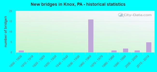
- New bridges - historical statistics
- 11900-1909
- 161960-1969
- 11980-1989
- 21990-1999
- 12000-2009
- 52010-2019

- Reconstructed bridges - Historical Statistics
- 11960-1969
- 01970-1979
- 01980-1989
- 01990-1999
- 42000-2009


- Bridge Condition - Deck
- 15.4%Very good
- 30.8%Good
- 46.2%Satisfactory
- 7.7%Fair

- Bridge Condition - Superstructure
- 23.1%Very good
- 7.7%Satisfactory
- 53.8%Fair
- 15.4%Poor

- Bridge Condition - Substructure
- 15.4%Very good
- 15.4%Good
- 30.8%Satisfactory
- 38.5%Fair

- Bridge Condition - Channel
- 46.2%Satisfactory
- 46.2%Fair
- 7.7%Poor

- Bridge Condition - Culverts
- 33.3%Good
- 66.7%Satisfactory
Find on map >> Show street view
Structure Number: 10939, Location: BEAVER CREEK EB (Lat: 41.189828, Lng: -79.563150), Route carried "on" structure: Interstate 80, Year Built: 1966, Year Reconstructed: 2013, Status: Open, Structure Length: 12.01m (39.40ft), Average Daily Traffic: 11,517 (year 2022), Truck Traffic: 46%, Average Future Daily Traffic: 14,295 (year 2032), Design Load: HS 20+Mod, Features Intersected: BEAVER CR & ABAND RR
Minimum Vertical Clearance: 30+ m (98+ ft), Kilometerpoint: 12.255, Lanes on structure: 2, Base Highway Network: Yes, Owner: State Highway Agency, Approaching Roadway Width: 10.1m (33.1ft), Skew: 10 degrees, Material/Design: Steel continuous, Design/Construction: Stringer/Multi-beam, Number Of Spans In Main Unit: 4, Length of Maximum Span: 36.0m (118.1ft), Curb or Sidewalk Widths: Left: 0.2m (0.7ft), Right: 0.2m (0.7ft), Curb-To-Curb Width: 10.1m (33.1ft), Out-to-Out Width: 11.1m (36.4ft)
Condition: Deck: Good, Superstructure: Fair, Substructure: Satisfactory, Channel: Satisfactory, Operating Rating: 68.0 metric tons, Method Used To Determine Operating Rating: Load Factor (LF), Inventory Rating: 40.8 metric tons, Method Used To Determine Inventory Rating: Load Factor (LF), Structural Evaluation: Somewhat better than minimum adequacy, Deck Geometry: Meets minimum limits, Waterway Adequacy: Superior to present desirable criteria, Approach Roadway Alignment: Equal to present desirable criteria, Length Of Structure Improvement: 13.10m (42.98ft), Designated Inspection Frequency: Every 24 months, Inspection Date: June 2021, Bridge Improvement Cost: $151,000, Roadway Improvement Cost: $536,000, Total Project Cost: $2,033,000, Deck Structure Type: Concrete Cast-file-Place, Wearing Surface/Protective System: Wearing Surface: Latex Concrete, Deck Protection: Epoxy Coated Reinforcing
Find on map >> Show street view
Structure Number: 1094, Location: BEAVER CREEK WB (Lat: 41.190106, Lng: -79.562756), Route carried "on" structure: Interstate 80, Year Built: 1966, Year Reconstructed: 2013, Status: Open, Structure Length: 12.01m (39.40ft), Average Daily Traffic: 12,519 (year 2022), Truck Traffic: 37%, Average Future Daily Traffic: 14,384 (year 2032), Design Load: HS 20+Mod, Features Intersected: BEAVER CREEK & ABAND RR
Minimum Vertical Clearance: 30+ m (98+ ft), Kilometerpoint: 12.345, Lanes on structure: 2, Base Highway Network: Yes, Owner: State Highway Agency, Approaching Roadway Width: 10.7m (35.1ft), Skew: 10 degrees, Material/Design: Steel continuous, Design/Construction: Stringer/Multi-beam, Number Of Spans In Main Unit: 4, Length of Maximum Span: 36.0m (118.1ft), Curb or Sidewalk Widths: Left: 0.2m (0.7ft), Right: 0.2m (0.7ft), Curb-To-Curb Width: 10.1m (33.1ft), Out-to-Out Width: 11.1m (36.4ft)
Condition: Deck: Good, Superstructure: Fair, Substructure: Good, Channel: Satisfactory, Operating Rating: 73.5 metric tons, Method Used To Determine Operating Rating: Load Factor (LF), Inventory Rating: 43.5 metric tons, Method Used To Determine Inventory Rating: Load Factor (LF), Structural Evaluation: Somewhat better than minimum adequacy, Deck Geometry: Meets minimum limits, Waterway Adequacy: Superior to present desirable criteria, Approach Roadway Alignment: Equal to present desirable criteria, Length Of Structure Improvement: 13.00m (42.65ft), Designated Inspection Frequency: Every 24 months, Inspection Date: June 2021, Bridge Improvement Cost: $78,000, Roadway Improvement Cost: $536,000, Total Project Cost: $1,051,000, Deck Structure Type: Concrete Cast-file-Place, Wearing Surface/Protective System: Wearing Surface: Latex Concrete, Deck Protection: Epoxy Coated Reinforcing
Find on map >> Show street view
Structure Number: 10941, Location: MYERS HILL EB (Lat: 41.184961, Lng: -79.554831), Route carried "on" structure: Interstate 80, Year Built: 1966, Status: Open, Structure Length: 3.17m (10.40ft), Average Daily Traffic: 11,517 (year 2022), Truck Traffic: 46%, Average Future Daily Traffic: 14,295 (year 2032), Design Load: H 20, Features Intersected: SR0338
Minimum Vertical Clearance: 30+ m (98+ ft), Kilometerpoint: 13.060, Lanes on structure: 2, Lanes under structure: 2, Base Highway Network: Yes, Owner: State Highway Agency, Approaching Roadway Width: 11.6m (38.1ft), Skew: 11 degrees, Material/Design: Prestressed concrete, Design/Construction: Box Beam or Girders - Single/Spread, Number Of Spans In Main Unit: 3, Length of Maximum Span: 11.0m (36.1ft), Curb or Sidewalk Widths: Left: 0.2m (0.7ft), Right: 0.2m (0.7ft), Curb-To-Curb Width: 12.9m (42.3ft), Out-to-Out Width: 13.9m (45.6ft)
Condition: Deck: Satisfactory, Superstructure: Satisfactory, Substructure: Satisfactory, Operating Rating: 68.0 metric tons, Method Used To Determine Operating Rating: Load Factor (LF), Inventory Rating: 40.8 metric tons, Method Used To Determine Inventory Rating: Load Factor (LF), Structural Evaluation: Equal to present minimum criteria, Deck Geometry: Superior to present desirable criteria, Underclear: Meets minimum limits, Approach Roadway Alignment: Equal to present desirable criteria, Length Of Structure Improvement: 3.90m (12.80ft), Designated Inspection Frequency: Every 48 months, Inspection Date: June 2019, Deck Structure Type: Concrete Cast-file-Place, Wearing Surface/Protective System: Wearing Surface: Epoxy Overlay, Membrane: Epoxy, Deck Protection: Epoxy Coated Reinforcing
Find on map >> Show street view
Structure Number: 10942, Location: MYERS HILL WB (Lat: 41.185269, Lng: -79.554294), Route carried "on" structure: Interstate 80, Year Built: 1966, Status: Open, Structure Length: 3.05m (10.01ft), Average Daily Traffic: 12,519 (year 2022), Truck Traffic: 37%, Average Future Daily Traffic: 14,384 (year 2032), Design Load: H 20, Features Intersected: SR0338
Minimum Vertical Clearance: 30+ m (98+ ft), Kilometerpoint: 13.144, Lanes on structure: 2, Lanes under structure: 2, Base Highway Network: Yes, Owner: State Highway Agency, Approaching Roadway Width: 11.6m (38.1ft), Skew: 11 degrees, Material/Design: Prestressed concrete, Design/Construction: Box Beam or Girders - Single/Spread, Number Of Spans In Main Unit: 3, Length of Maximum Span: 11.0m (36.1ft), Curb or Sidewalk Widths: Left: 0.2m (0.7ft), Right: 0.2m (0.7ft), Curb-To-Curb Width: 12.9m (42.3ft), Out-to-Out Width: 13.9m (45.6ft)
Condition: Deck: Satisfactory, Superstructure: Fair, Substructure: Satisfactory, Operating Rating: 76.2 metric tons, Method Used To Determine Operating Rating: Load Factor (LF), Inventory Rating: 36.3 metric tons, Method Used To Determine Inventory Rating: Load Factor (LF), Structural Evaluation: Somewhat better than minimum adequacy, Deck Geometry: Superior to present desirable criteria, Underclear: Meets minimum limits, Approach Roadway Alignment: Equal to present desirable criteria, Length Of Structure Improvement: 3.80m (12.47ft), Designated Inspection Frequency: Every 24 months, Inspection Date: June 2021, Deck Structure Type: Concrete Cast-file-Place, Wearing Surface/Protective System: Wearing Surface: Epoxy Overlay, Membrane: Epoxy, Deck Protection: Epoxy Coated Reinforcing
Find on map >> Show street view
Structure Number: 10944, Location: CANOE CREEK EB (Lat: 41.189406, Lng: -79.514856), Route carried "on" structure: Interstate 80, Year Built: 1966, Year Reconstructed: 2013, Status: Open, Structure Length: 35.23m (115.58ft), Average Daily Traffic: 11,928 (year 2022), Truck Traffic: 65%, Average Future Daily Traffic: 15,008 (year 2032), Design Load: HS 20+Mod, Features Intersected: SR 4005 & CANOE CREEK
Minimum Vertical Clearance: 30+ m (98+ ft), Kilometerpoint: 17.080, Lanes on structure: 2, Lanes under structure: 2, Base Highway Network: Yes, Owner: State Highway Agency, Approaching Roadway Width: 10.7m (35.1ft), Skew: 10 degrees, Material/Design: Steel continuous, Design/Construction: Girder and Floorbeam System, Number Of Spans In Main Unit: 5, Number Of Approach Spans: 4, Length of Maximum Span: 49.1m (161.1ft), Curb or Sidewalk Widths: Left: 0.2m (0.7ft), Right: 0.2m (0.7ft), Curb-To-Curb Width: 10.1m (33.1ft), Out-to-Out Width: 11.1m (36.4ft)
Condition: Deck: Satisfactory, Superstructure: Fair, Substructure: Satisfactory, Channel: Satisfactory, Operating Rating: 59.0 metric tons, Method Used To Determine Operating Rating: Load Factor (LF), Inventory Rating: 35.4 metric tons, Method Used To Determine Inventory Rating: Load Factor (LF), Structural Evaluation: Somewhat better than minimum adequacy, Deck Geometry: Meets minimum limits, Underclear: Superior to present desirable criteria, Waterway Adequacy: Superior to present desirable criteria, Approach Roadway Alignment: Equal to present desirable criteria, Length Of Structure Improvement: 33.20m (108.92ft), Designated Inspection Frequency: Every 24 months, Critical Feature Inspection Frequency: Every 24 months, Other Special Inspection Frequency: Every 12 months, Inspection Date: July 2021, Critical Feature Inspection Date: July 2021, Other Special Inspection Date: July 2021, Bridge Improvement Cost: $41,000, Roadway Improvement Cost: $120,000, Total Project Cost: $551,000, Deck Structure Type: Concrete Cast-file-Place, Wearing Surface/Protective System: Wearing Surface: Latex Concrete, Deck Protection: Epoxy Coated Reinforcing
Find on map >> Show street view
Structure Number: 10945, Location: CANOE CREEK WB (Lat: 41.189744, Lng: -79.515322), Route carried "on" structure: Interstate 80, Year Built: 1966, Year Reconstructed: 2013, Status: Open, Structure Length: 33.22m (108.99ft), Average Daily Traffic: 12,444 (year 2022), Truck Traffic: 70%, Average Future Daily Traffic: 14,845 (year 2032), Design Load: HS 20+Mod, Features Intersected: SR 4005 & CANOE CREEK
Minimum Vertical Clearance: 30+ m (98+ ft), Kilometerpoint: 17.049, Lanes on structure: 2, Lanes under structure: 2, Base Highway Network: Yes, Owner: State Highway Agency, Approaching Roadway Width: 10.7m (35.1ft), Skew: 10 degrees, Material/Design: Steel continuous, Design/Construction: Girder and Floorbeam System, Number Of Spans In Main Unit: 5, Number Of Approach Spans: 3, Length of Maximum Span: 49.1m (161.1ft), Curb or Sidewalk Widths: Left: 0.2m (0.7ft), Right: 0.2m (0.7ft), Curb-To-Curb Width: 10.1m (33.1ft), Out-to-Out Width: 11.1m (36.4ft)
Condition: Deck: Satisfactory, Superstructure: Poor, Substructure: Fair, Channel: Satisfactory, Operating Rating: 59.0 metric tons, Method Used To Determine Operating Rating: Load Factor (LF), Inventory Rating: 35.4 metric tons, Method Used To Determine Inventory Rating: Load Factor (LF), Structural Evaluation: Meets minimum limits, Deck Geometry: Meets minimum limits, Underclear: Somewhat better than minimum adequacy, Waterway Adequacy: Superior to present desirable criteria, Approach Roadway Alignment: Equal to present desirable criteria, Length Of Structure Improvement: 35.80m (117.45ft), Designated Inspection Frequency: Every 24 months, Critical Feature Inspection Frequency: Every 6 months, Other Special Inspection Frequency: Every 6 months, Inspection Date: July 2021, Critical Feature Inspection Date: July 2021, Other Special Inspection Date: July 2021, Bridge Improvement Cost: $594,000, Roadway Improvement Cost: $4,414,000, Total Project Cost: $8,014,000, Deck Structure Type: Concrete Cast-file-Place, Wearing Surface/Protective System: Wearing Surface: Latex Concrete, Deck Protection: Epoxy Coated Reinforcing
Find on map >> Show street view
Structure Number: 10965, Location: PILGRIMHAM NO.2 (Lat: 41.230281, Lng: -79.579906), Route carried "on" structure: State highway 208, Year Built: 1985, Status: Open, Structure Length: 1.07m (3.51ft), Average Daily Traffic: 1,795 (year 2022), Truck Traffic: 9%, Average Future Daily Traffic: 2,261 (year 2032), Design Load: HS 20, Features Intersected: BEAVER CREEK
Minimum Vertical Clearance: 30+ m (98+ ft), Kilometerpoint: 7.871, Lanes on structure: 2, Base Highway Network: Yes, Owner: State Highway Agency, Approaching Roadway Width: 9.4m (30.8ft), Material/Design: Prestressed concrete, Design/Construction: Box Beam or Girders - Multiple, Number Of Spans In Main Unit: 1, Length of Maximum Span: 9.8m (32.2ft), Curb or Sidewalk Widths: Left: 0.2m (0.7ft), Right: 0.2m (0.7ft), Curb-To-Curb Width: 11.7m (38.4ft), Out-to-Out Width: 12.6m (41.3ft)
Condition: Deck: Fair, Superstructure: Fair, Substructure: Fair, Channel: Poor, Operating Rating: 77.1 metric tons, Method Used To Determine Operating Rating: Load Factor (LF), Inventory Rating: 39.0 metric tons, Method Used To Determine Inventory Rating: Load Factor (LF), Structural Evaluation: Somewhat better than minimum adequacy, Deck Geometry: Equal to present minimum criteria, Waterway Adequacy: Equal to present minimum criteria, Approach Roadway Alignment: Equal to present desirable criteria, Length Of Structure Improvement: 1.80m (5.91ft), Designated Inspection Frequency: Every 24 months, Inspection Date: April 2021, Bridge Improvement Cost: $9,000, Roadway Improvement Cost: $26,000, Total Project Cost: $120,000, Deck Structure Type: Other, Wearing Surface/Protective System: Wearing Surface: Bituminous
Find on map >> Show street view
Structure Number: 10967, Location: KNOX NO.2 (Lat: 41.236639, Lng: -79.522331), Route carried "on" structure: State highway 208, Year Built: 1996, Status: Open, Structure Length: 0.98m (3.22ft), Average Daily Traffic: 3,998 (year 2021), Truck Traffic: 10%, Average Future Daily Traffic: 5,550 (year 2032), Design Load: HS 20, Features Intersected: CANOE CREEK
Minimum Vertical Clearance: 30+ m (98+ ft), Kilometerpoint: 13.002, Lanes on structure: 2, Base Highway Network: Yes, Owner: State Highway Agency, Approaching Roadway Width: 8.8m (28.9ft), Material/Design: Concrete, Design/Construction: Culvert, Number Of Spans In Main Unit: 2, Length of Maximum Span: 9.8m (32.2ft), Curb-To-Curb Width: 12.5m (41.0ft), Out-to-Out Width: 13.5m (44.3ft)
Condition: Channel: Fair, Culverts: Satisfactory, Operating Rating: 92.5 metric tons, Method Used To Determine Operating Rating: Load Factor (LF), Inventory Rating: 55.3 metric tons, Method Used To Determine Inventory Rating: Load Factor (LF), Structural Evaluation: Equal to present minimum criteria, Deck Geometry: Equal to present minimum criteria, Waterway Adequacy: Equal to present minimum criteria, Approach Roadway Alignment: Equal to present desirable criteria, Length Of Structure Improvement: 1.60m (5.25ft), Designated Inspection Frequency: Every 48 months, Inspection Date: May 2019, Wearing Surface/Protective System: Wearing Surface: Bituminous, Membrane: Preformed Fabric, Deck Protection: Epoxy Coated Reinforcing
Find on map >> Show street view
Structure Number: 11102, Location: 0.5 mi SW, int w/ SR 208 (Lat: 41.233133, Lng: -79.519625), Route carried "on" structure: City street , Year Built: 1902, Year Reconstructed: 1965, Status: Posted for load, Structure Length: 0.79m (2.59ft), Average Daily Traffic: 50 (year 2021), Average Future Daily Traffic: 70 (year 2043), Features Intersected: CANOE CREEK, Facility Carried by Structure: T-327 SHETTLER RD
Minimum Vertical Clearance: 30+ m (98+ ft), Kilometerpoint: 0.000, Lanes on structure: 1, Owner: Town or Township Highway Agency, Approaching Roadway Width: 4.0m (13.1ft), Material/Design: Steel, Design/Construction: Stringer/Multi-beam, Number Of Spans In Main Unit: 1, Length of Maximum Span: 7.3m (24.0ft), Curb-To-Curb Width: 4.7m (15.4ft), Out-to-Out Width: 4.9m (16.1ft)
Condition: Deck: Good, Superstructure: Poor, Substructure: Fair, Channel: Fair, Operating Rating: 6.4 metric tons, Method Used To Determine Operating Rating: Load and Resistance Factor (LRFR), Inventory Rating: 4.5 metric tons, Method Used To Determine Inventory Rating: Load and Resistance Factor (LRFR), Structural Evaluation: High priority of replacement, Deck Geometry: Better than present minimum criteria, Waterway Adequacy: Equal to present minimum criteria, Approach Roadway Alignment: Better than present minimum criteria, Bridge Posting: Required (Relationship of Operating Rating to Maximum Legal Load: > 39.9% below), Length Of Structure Improvement: 1.00m (3.28ft), Designated Inspection Frequency: Every 24 months, Other Special Inspection Frequency: Every 12 months, Inspection Date: May 2021, Other Special Inspection Date: May 2021, Bridge Improvement Cost: $13,000, Roadway Improvement Cost: $38,000, Total Project Cost: $174,000, Deck Structure Type: Concrete Cast-file-Place, Wearing Surface/Protective System: Wearing Surface: Monolithic Concrete
Find on map >> Show street view
Structure Number: 11103, Location: 0.5 mi WNW, int w/ SR4005 (Lat: 41.203000, Lng: -79.565197), Route carried "on" structure: City street , Year Built: 1960, Status: Posted for load, Structure Length: 1.37m (4.49ft), Average Daily Traffic: 50 (year 2020), Truck Traffic: 10%, Average Future Daily Traffic: 77 (year 2042), Features Intersected: BEAVER CREEK, Facility Carried by Structure: T-391 JEFFERSON RD
Minimum Vertical Clearance: 30+ m (98+ ft), Kilometerpoint: 0.000, Lanes on structure: 1, Owner: Town or Township Highway Agency, Approaching Roadway Width: 6.1m (20.0ft), Skew: 1 degrees, Material/Design: Steel, Design/Construction: Stringer/Multi-beam, Number Of Spans In Main Unit: 1, Length of Maximum Span: 12.8m (42.0ft), Curb-To-Curb Width: 4.1m (13.5ft), Out-to-Out Width: 4.3m (14.1ft)
Condition: Deck: Satisfactory, Superstructure: Fair, Substructure: Fair, Channel: Fair, Operating Rating: 25.4 metric tons, Method Used To Determine Operating Rating: Allowable Stress (AS), Inventory Rating: 19.1 metric tons, Method Used To Determine Inventory Rating: Allowable Stress (AS), Structural Evaluation: Somewhat better than minimum adequacy, Deck Geometry: Somewhat better than minimum adequacy, Waterway Adequacy: Better than present minimum criteria, Approach Roadway Alignment: Somewhat better than minimum adequacy, Bridge Posting: Required (Relationship of Operating Rating to Maximum Legal Load: 20.0 - 29.9% below), Length Of Structure Improvement: 1.70m (5.58ft), Designated Inspection Frequency: Every 24 months, Other Special Inspection Frequency: Every 12 months, Inspection Date: March 2021, Other Special Inspection Date: March 2021, Bridge Improvement Cost: $26,000, Roadway Improvement Cost: $100,000, Total Project Cost: $351,000, Deck Structure Type: Concrete Cast-file-Place, Wearing Surface/Protective System: Wearing Surface: Monolithic Concrete
Find on map >> Show street view
Structure Number: 11104, Location: 0.6 mi SW, int w/ SR4005 (Lat: 41.193969, Lng: -79.562500), Route carried "on" structure: City street , Year Built: 1960, Status: Posted for load, Structure Length: 1.43m (4.69ft), Average Daily Traffic: 50 (year 2021), Average Future Daily Traffic: 77 (year 2043), Features Intersected: BEAVER CREEK, Facility Carried by Structure: T-383 COULTER RD
Minimum Vertical Clearance: 30+ m (98+ ft), Kilometerpoint: 0.000, Lanes on structure: 1, Owner: Town or Township Highway Agency, Approaching Roadway Width: 4.9m (16.1ft), Material/Design: Steel, Design/Construction: Stringer/Multi-beam, Number Of Spans In Main Unit: 1, Length of Maximum Span: 13.4m (44.0ft), Curb-To-Curb Width: 4.3m (14.1ft), Out-to-Out Width: 4.3m (14.1ft)
Condition: Deck: Satisfactory, Superstructure: Fair, Substructure: Fair, Channel: Fair, Operating Rating: 6.4 metric tons, Method Used To Determine Operating Rating: Load and Resistance Factor (LRFR), Inventory Rating: 4.5 metric tons, Method Used To Determine Inventory Rating: Load and Resistance Factor (LRFR), Structural Evaluation: High priority of corrective action, Deck Geometry: Equal to present minimum criteria, Waterway Adequacy: Better than present minimum criteria, Approach Roadway Alignment: Somewhat better than minimum adequacy, Bridge Posting: Required (Relationship of Operating Rating to Maximum Legal Load: > 39.9% below), Length Of Structure Improvement: 1.80m (5.91ft), Designated Inspection Frequency: Every 24 months, Other Special Inspection Frequency: Every 12 months, Inspection Date: July 2021, Other Special Inspection Date: July 2021, Bridge Improvement Cost: $27,000, Roadway Improvement Cost: $100,000, Total Project Cost: $359,000, Deck Structure Type: Concrete Cast-file-Place, Wearing Surface/Protective System: Wearing Surface: Monolithic Concrete
Find on map >> Show street view
Structure Number: 11108, Location: 0.7 mi E, int w/ SR 338 (Lat: 41.244436, Lng: -79.524097), Route carried "on" structure: City street , Year Built: 1997, Status: Open, Structure Length: 0.79m (2.59ft), Average Daily Traffic: 50 (year 2021), Truck Traffic: 10%, Average Future Daily Traffic: 70 (year 2043), Features Intersected: CANOE CREEK, Facility Carried by Structure: T-407 CULBERTSON
Minimum Vertical Clearance: 30+ m (98+ ft), Kilometerpoint: 0.000, Lanes on structure: 2, Owner: Town or Township Highway Agency, Approaching Roadway Width: 4.3m (14.1ft), Material/Design: Concrete, Design/Construction: Culvert, Number Of Spans In Main Unit: 1, Length of Maximum Span: 7.3m (24.0ft), Curb-To-Curb Width: 6.4m (21.0ft), Out-to-Out Width: 7.5m (24.6ft)
Condition: Channel: Fair, Culverts: Satisfactory, Operating Rating: 49.0 metric tons, Method Used To Determine Operating Rating: Field evaluation and documented engineering judgment, Inventory Rating: 32.7 metric tons, Method Used To Determine Inventory Rating: Field evaluation and documented engineering judgment, Structural Evaluation: Equal to present minimum criteria, Deck Geometry: Somewhat better than minimum adequacy, Waterway Adequacy: Better than present minimum criteria, Approach Roadway Alignment: Equal to present desirable criteria, Length Of Structure Improvement: 1.40m (4.59ft), Designated Inspection Frequency: Every 24 months, Inspection Date: September 2021, Wearing Surface/Protective System: Wearing Surface: Bituminous
Find on map >> Show street view
Structure Number: 44176, Location: 1 mi N, int w/ SR 208 (Lat: 41.246300, Lng: -79.582422), Route carried "on" structure: City street , Year Built: 2007, Status: Open, Structure Length: 0.79m (2.59ft), Average Daily Traffic: 50 (year 2021), Truck Traffic: 10%, Average Future Daily Traffic: 70 (year 2043), Design Load: HL 93, Features Intersected: BEAVER CREEK, Facility Carried by Structure: T-336 BITTERSWEET
Minimum Vertical Clearance: 30+ m (98+ ft), Kilometerpoint: 0.000, Lanes on structure: 2, Owner: Town or Township Highway Agency, Approaching Roadway Width: 7.3m (24.0ft), Skew: 2 degrees, Material/Design: Concrete, Design/Construction: Culvert, Number Of Spans In Main Unit: 1, Length of Maximum Span: 7.0m (23.0ft)
Condition: Channel: Satisfactory, Culverts: Good, Operating Rating: 81.6 metric tons, Method Used To Determine Operating Rating: Load and Resistance Factor (LRFR), Inventory Rating: 62.6 metric tons, Method Used To Determine Inventory Rating: Load and Resistance Factor (LRFR), Structural Evaluation: Better than present minimum criteria, Waterway Adequacy: Better than present minimum criteria, Approach Roadway Alignment: Equal to present desirable criteria, Designated Inspection Frequency: Every 24 months, Inspection Date: August 2021
Find on map >> Show street view
Structure Number: 46802, Location: 0.5mi. SW SR 80 (Lat: 41.181506, Lng: -79.561075), Route carried "on" structure: State highway 338, Year Built: 2011, Status: Open, Structure Length: 2.32m (7.61ft), Average Daily Traffic: 1,536 (year 2022), Truck Traffic: 15%, Average Future Daily Traffic: 2,036 (year 2032), Design Load: HL 93, Features Intersected: BEAVER CREEK
Minimum Vertical Clearance: 30+ m (98+ ft), Kilometerpoint: 7.643, Lanes on structure: 2, Owner: State Highway Agency, Approaching Roadway Width: 9.4m (30.8ft), Material/Design: Prestressed concrete, Design/Construction: Stringer/Multi-beam, Number Of Spans In Main Unit: 1, Length of Maximum Span: 22.3m (73.2ft), Curb or Sidewalk Widths: Left: 0.2m (0.7ft), Right: 0.2m (0.7ft), Curb-To-Curb Width: 9.8m (32.2ft), Out-to-Out Width: 10.8m (35.4ft)
Condition: Deck: Good, Superstructure: Very good, Substructure: Good, Channel: Satisfactory, Operating Rating: 67.7 metric tons, Method Used To Determine Operating Rating: Assigned ratings based on Load and Resistance Factor Design (LRFD) reported by rating factor (RF) using HL93 loadings, Inventory Rating: 35.0 metric tons, Method Used To Determine Inventory Rating: Assigned ratings based on Load and Resistance Factor Design (LRFD) reported by rating factor (RF) using HL93 loadings, Structural Evaluation: Better than present minimum criteria, Deck Geometry: Somewhat better than minimum adequacy, Waterway Adequacy: Superior to present desirable criteria, Approach Roadway Alignment: Better than present minimum criteria, Designated Inspection Frequency: Every 48 months, Inspection Date: June 2019, Deck Structure Type: Concrete Cast-file-Place, Wearing Surface/Protective System: Wearing Surface: Monolithic Concrete, Deck Protection: Epoxy Coated Reinforcing
Find on map >> Show street view
Structure Number: 52495, Location: 2.1 Mi E SR 3007 Inter. (Lat: 41.189906, Lng: -79.515458), Route carried "on" structure: State highway , Year Built: 2015, Status: Open, Structure Length: 2.16m (7.09ft), Average Daily Traffic: 158 (year 2022), Truck Traffic: 10%, Average Future Daily Traffic: 184 (year 2032), Design Load: HL 93, Features Intersected: CANOE CREEK, Facility Carried by Structure: SR 4005
Minimum Vertical Clearance: 30+ m (98+ ft), Kilometerpoint: 2.578, Lanes on structure: 2, Owner: State Highway Agency, Approaching Roadway Width: 7.9m (25.9ft), Skew: 2 degrees, Material/Design: Prestressed concrete, Design/Construction: Stringer/Multi-beam, Number Of Spans In Main Unit: 1, Length of Maximum Span: 20.7m (67.9ft), Curb or Sidewalk Widths: Left: 0.2m (0.7ft), Right: 0.2m (0.7ft), Curb-To-Curb Width: 8.0m (26.2ft), Out-to-Out Width: 9.0m (29.5ft)
Condition: Deck: Very good, Superstructure: Very good, Substructure: Very good, Channel: Fair, Operating Rating: 50.2 metric tons, Method Used To Determine Operating Rating: Assigned ratings based on Load and Resistance Factor Design (LRFD) reported by rating factor (RF) using HL93 loadings, Inventory Rating: 38.9 metric tons, Method Used To Determine Inventory Rating: Assigned ratings based on Load and Resistance Factor Design (LRFD) reported by rating factor (RF) using HL93 loadings, Structural Evaluation: Equal to present desirable criteria, Deck Geometry: Somewhat better than minimum adequacy, Waterway Adequacy: Superior to present desirable criteria, Approach Roadway Alignment: Better than present minimum criteria, Designated Inspection Frequency: Every 48 months, Inspection Date: June 2021, Deck Structure Type: Concrete Cast-file-Place, Wearing Surface/Protective System: Wearing Surface: Monolithic Concrete, Deck Protection: Epoxy Coated Reinforcing
Find on map >> Show street view
Structure Number: 54547, Location: SR 2007 & SR 80 Inter. (Lat: 41.200028, Lng: -79.493083), Route carried "on" structure: State highway , Year Built: 2017, Status: Open, Structure Length: 9.69m (31.79ft), Average Daily Traffic: 375 (year 2022), Truck Traffic: 8%, Average Future Daily Traffic: 470 (year 2032), Design Load: HL 93, Features Intersected: SR 80 EB&WB, Facility Carried by Structure: SR 2007
Minimum Vertical Clearance: 30+ m (98+ ft), Kilometerpoint: 25.434, Lanes on structure: 2, Lanes under structure: 4, Owner: State Highway Agency, Approaching Roadway Width: 8.5m (27.9ft), Skew: 1 degrees, Material/Design: Prestressed concrete continuous, Design/Construction: Stringer/Multi-beam, Number Of Spans In Main Unit: 3, Number Of Approach Spans: 2, Length of Maximum Span: 21.9m (71.9ft), Curb or Sidewalk Widths: Left: 0.2m (0.7ft), Right: 0.2m (0.7ft), Curb-To-Curb Width: 8.6m (28.2ft), Out-to-Out Width: 9.6m (31.5ft)
Condition: Deck: Very good, Superstructure: Very good, Substructure: Very good, Operating Rating: 47.3 metric tons, Method Used To Determine Operating Rating: Assigned ratings based on Load and Resistance Factor Design (LRFD) reported by rating factor (RF) using HL93 loadings, Inventory Rating: 36.6 metric tons, Method Used To Determine Inventory Rating: Assigned ratings based on Load and Resistance Factor Design (LRFD) reported by rating factor (RF) using HL93 loadings, Structural Evaluation: Equal to present desirable criteria, Deck Geometry: Equal to present minimum criteria, Underclear: Equal to present minimum criteria, Approach Roadway Alignment: Equal to present desirable criteria, Designated Inspection Frequency: Every 48 months, Inspection Date: September 2019, Deck Structure Type: Concrete Cast-file-Place, Wearing Surface/Protective System: Wearing Surface: Monolithic Concrete, Deck Protection: Epoxy Coated Reinforcing
Find on map >> Show street view
Structure Number: 10941, Location: MYERS HILL EB (Lat: 41.184961, Lng: -79.554831), Route carried "under" structure: State highway 338, Year Built: 1966, Structure Length: 0. m, Average Daily Traffic: 1,536 (year 2022), Truck Traffic: 15%, Features Intersected: SR0338, Facility Carried by Structure: SR0080 EB
Minimum Vertical Clearance: 5.05m (16.57ft), Kilometerpoint: 8.212, Lanes on structure: 2, Lanes under structure: 2, Material/Design: Prestressed concrete, Design/Construction: Box Beam or Girders - Single/Spread, Length of Maximum Span: 11.0m (36.1ft)
Find on map >> Show street view
Structure Number: 10942, Location: MYERS HILL WB (Lat: 41.185269, Lng: -79.554294), Route carried "under" structure: State highway 338, Year Built: 1966, Structure Length: 0. m, Average Daily Traffic: 1,536 (year 2022), Truck Traffic: 15%, Features Intersected: SR0338, Facility Carried by Structure: SR0080 WB
Minimum Vertical Clearance: 4.62m (15.16ft), Kilometerpoint: 8.212, Lanes on structure: 2, Lanes under structure: 2, Material/Design: Prestressed concrete, Design/Construction: Box Beam or Girders - Single/Spread, Length of Maximum Span: 11.0m (36.1ft)
Find on map >> Show street view
Structure Number: 10944, Location: CANOE CREEK EB (Lat: 41.189406, Lng: -79.514856), Route carried "under" structure: State highway , Year Built: 1966, Structure Length: 0. m, Average Daily Traffic: 158 (year 2022), Truck Traffic: 10%, Features Intersected: SR 4005 & CANOE CREEK, Facility Carried by Structure: SR 0080 EB
Minimum Vertical Clearance: 28.96m (95.01ft), Kilometerpoint: 2.578, Lanes on structure: 2, Lanes under structure: 2, Material/Design: Steel continuous, Design/Construction: Girder and Floorbeam System, Length of Maximum Span: 49.1m (161.1ft)
Find on map >> Show street view
Structure Number: 10945, Location: CANOE CREEK WB (Lat: 41.189744, Lng: -79.515322), Route carried "under" structure: State highway , Year Built: 1966, Structure Length: 0. m, Average Daily Traffic: 158 (year 2022), Truck Traffic: 10%, Features Intersected: SR 4005 & CANOE CREEK, Facility Carried by Structure: SR 0080 WB
Minimum Vertical Clearance: 29.57m (97.01ft), Kilometerpoint: 2.578, Lanes on structure: 2, Lanes under structure: 2, Material/Design: Steel continuous, Design/Construction: Girder and Floorbeam System, Length of Maximum Span: 49.1m (161.1ft)
Find on map >> Show street view
Structure Number: 10983, Location: MONROE (Lat: 41.193203, Lng: -79.587644), Route carried "under" structure: Interstate 80, Year Built: 1966, Structure Length: 0. m, Average Daily Traffic: 12,519 (year 2022), Truck Traffic: 37%, Features Intersected: SR-0080 EB & WB, Facility Carried by Structure: SR-0338
Minimum Vertical Clearance: 5.38m (17.65ft), Kilometerpoint: 9.835, Lanes on structure: 2, Lanes under structure: 2, Material/Design: Prestressed concrete, Design/Construction: Box Beam or Girders - Single/Spread, Length of Maximum Span: 20.4m (66.9ft)
Find on map >> Show street view
Structure Number: 10983, Location: MONROE (Lat: 41.193203, Lng: -79.587644), Route carried "under" structure: Interstate 80, Year Built: 1966, Structure Length: 0. m, Average Daily Traffic: 11,517 (year 2022), Truck Traffic: 46%, Features Intersected: SR-0080 EB & WB, Facility Carried by Structure: SR-0338
Minimum Vertical Clearance: 5.22m (17.13ft), Kilometerpoint: 9.865, Lanes on structure: 2, Lanes under structure: 2, Material/Design: Prestressed concrete, Design/Construction: Box Beam or Girders - Single/Spread, Length of Maximum Span: 20.4m (66.9ft)
Find on map >> Show street view
Structure Number: 11068, Location: WENTLINGS CORNERS (Lat: 41.184408, Lng: -79.541589), Route carried "under" structure: Interstate 80, Year Built: 1966, Structure Length: 0. m, Average Daily Traffic: 11,928 (year 2022), Truck Traffic: 65%, Features Intersected: SR0080 EB&WB, Facility Carried by Structure: SR3007
Minimum Vertical Clearance: 5.33m (17.49ft), Kilometerpoint: 14.671, Lanes on structure: 2, Lanes under structure: 2, Material/Design: Prestressed concrete continuous, Design/Construction: Box Beam or Girders - Single/Spread, Length of Maximum Span: 19.2m (63.0ft)
Find on map >> Show street view
Structure Number: 11068, Location: WENTLINGS CORNERS (Lat: 41.184408, Lng: -79.541589), Route carried "under" structure: Interstate 80, Year Built: 1966, Structure Length: 0. m, Average Daily Traffic: 12,444 (year 2022), Truck Traffic: 70%, Features Intersected: SR0080 EB&WB, Facility Carried by Structure: SR3007
Minimum Vertical Clearance: 5.28m (17.32ft), Kilometerpoint: 14.706, Lanes on structure: 2, Lanes under structure: 2, Material/Design: Prestressed concrete continuous, Design/Construction: Box Beam or Girders - Single/Spread, Length of Maximum Span: 19.2m (63.0ft)
Find on map >> Show street view
Structure Number: 54547, Location: SR 2007 & SR 80 Inter. (Lat: 41.200028, Lng: -79.493083), Route carried "under" structure: Interstate 80, Year Built: 2017, Structure Length: 0. m, Average Daily Traffic: 11,928 (year 2022), Truck Traffic: 65%, Features Intersected: SR 80 EB&WB, Facility Carried by Structure: SR 2007
Minimum Vertical Clearance: 5.91m (19.39ft), Kilometerpoint: 19.529, Lanes on structure: 2, Lanes under structure: 2, Material/Design: Prestressed concrete continuous, Design/Construction: Stringer/Multi-beam, Length of Maximum Span: 21.9m (71.9ft)
Find on map >> Show street view
Structure Number: 54547, Location: SR 2007 & SR 80 Inter. (Lat: 41.200028, Lng: -79.493083), Route carried "under" structure: Interstate 80, Year Built: 2017, Structure Length: 0. m, Average Daily Traffic: 12,444 (year 2022), Truck Traffic: 70%, Features Intersected: SR 80 EB&WB, Facility Carried by Structure: SR 2007
Minimum Vertical Clearance: 5.58m (18.31ft), Kilometerpoint: 19.541, Lanes on structure: 2, Lanes under structure: 2, Material/Design: Prestressed concrete continuous, Design/Construction: Stringer/Multi-beam, Length of Maximum Span: 21.9m (71.9ft)