Bridge Statistics for Kirtland, Ohio (OH)
Condition, Traffic, Stress, Structural Evaluation, Project Costs
- National Bridge Inventory (NBI) Statistics
- 14Number of bridges
- 95ft / 29.4mTotal length
- $190,185,000Total costs
- 39,470Total average daily traffic
- 1,297Total average daily truck traffic
- National Bridge Inventory (NBI) Registered Bridges for Kirtland
- No street view available for this location
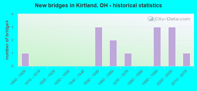
- New bridges - historical statistics
- 11900-1909
- 31950-1959
- 21960-1969
- 11970-1979
- 31990-1999
- 32000-2009
- 12010-2019

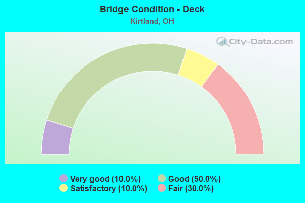
- Bridge Condition - Deck
- 10.0%Very good
- 50.0%Good
- 10.0%Satisfactory
- 30.0%Fair
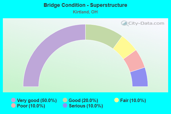
- Bridge Condition - Superstructure
- 50.0%Very good
- 20.0%Good
- 10.0%Fair
- 10.0%Poor
- 10.0%Serious
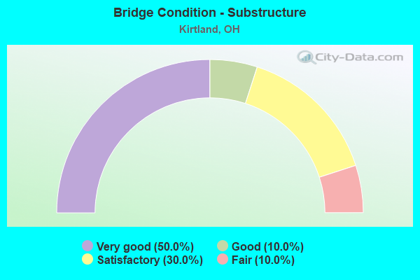
- Bridge Condition - Substructure
- 50.0%Very good
- 10.0%Good
- 30.0%Satisfactory
- 10.0%Fair
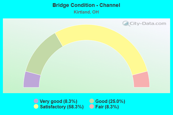
- Bridge Condition - Channel
- 8.3%Very good
- 25.0%Good
- 58.3%Satisfactory
- 8.3%Fair

- Bridge Condition - Culverts
- 33.3%Very good
- 66.7%Satisfactory
Find on map >> Show street view
Structure Number: 2830426, Location: 900 FT WEST OF US6 INT (Lat: 41.588331, Lng: -81.269461), Route carried "on" structure: County highway C0017, Year Built: 1958, Status: Open, Structure Length: 1.23m (4.04ft), Average Daily Traffic: 2,979 (year 2017), Truck Traffic: 2%, Average Future Daily Traffic: 4,135 (year 2037), Features Intersected: ALL SOULS CEMETERY, Facility Carried by Structure: KIRTLAND RD
Minimum Vertical Clearance: 30+ m (98+ ft), Kilometerpoint: 2.334, Lanes on structure: 2, Lanes under structure: 2, Owner: Private, Approaching Roadway Width: 6.1m (20.0ft), Skew: 1 degrees, Material/Design: Steel, Design/Construction: Culvert, Number Of Spans In Main Unit: 2, Length of Maximum Span: 4.9m (16.1ft)
Condition: Culverts: Satisfactory, Operating Rating: 55.1 metric tons, Method Used To Determine Operating Rating: Load Factor (LF) rating reported by rating factor (RF) method using MS18 loading, Inventory Rating: 51.8 metric tons, Method Used To Determine Inventory Rating: Load Factor (LF) rating reported by rating factor (RF) method using MS18 loading, Structural Evaluation: Equal to present minimum criteria, Underclear: High priority of corrective action, Approach Roadway Alignment: Better than present minimum criteria, Designated Inspection Frequency: Every 12 months, Inspection Date: December 2021, Wearing Surface/Protective System: Wearing Surface: Bituminous
Find on map >> Show street view
Structure Number: 2831016, Location: .4 Mi N. of Mulberry Rd (Lat: 41.567811, Lng: -81.304861), Route carried "on" structure: County highway T0105, Year Built: 2015, Status: Open, Structure Length: 0.79m (2.59ft), Average Daily Traffic: 184 (year 2017), Truck Traffic: 2%, Average Future Daily Traffic: 255 (year 2037), Design Load: HL 93, Features Intersected: HARRISS CREEK, Facility Carried by Structure: HEATH RD
Minimum Vertical Clearance: 30+ m (98+ ft), Kilometerpoint: 0.837, Lanes on structure: 2, Owner: County Highway Agency, Approaching Roadway Width: 7.3m (24.0ft), Material/Design: Concrete, Design/Construction: Frame, Number Of Spans In Main Unit: 1, Length of Maximum Span: 7.3m (24.0ft), Curb-To-Curb Width: 7.3m (24.0ft), Out-to-Out Width: 7.3m (24.0ft)
Condition: Deck: Very good, Superstructure: Very good, Substructure: Very good, Channel: Satisfactory, Operating Rating: 51.8 metric tons, Method Used To Determine Operating Rating: Load Factor (LF) rating reported by rating factor (RF) method using MS18 loading, Inventory Rating: 32.4 metric tons, Method Used To Determine Inventory Rating: Load Factor (LF) rating reported by rating factor (RF) method using MS18 loading, Structural Evaluation: Equal to present desirable criteria, Deck Geometry: Somewhat better than minimum adequacy, Waterway Adequacy: Better than present minimum criteria, Approach Roadway Alignment: Equal to present desirable criteria, Length Of Structure Improvement: 0.79m (2.59ft), Designated Inspection Frequency: Every 24 months, Inspection Date: December 2021, Total Project Cost: $190,000,000, Deck Structure Type: Concrete Cast-file-Place, Wearing Surface/Protective System: Wearing Surface: Bituminous, Membrane: Preformed Fabric, Deck Protection: Other
Find on map >> Show street view
Structure Number: 2831384, Location: INT.OF GEM AND HEATH RDS. (Lat: 41.569931, Lng: -81.305189), Route carried "on" structure: County highway T0264, Year Built: 1990, Status: Open, Structure Length: 2.59m (8.50ft), Average Daily Traffic: 305 (year 2017), Truck Traffic: 2%, Average Future Daily Traffic: 423 (year 2037), Design Load: HS 20+Mod, Features Intersected: E BR CHAGRIN RIVER, Facility Carried by Structure: GEM RD
Minimum Vertical Clearance: 30+ m (98+ ft), Kilometerpoint: 0.467, Lanes on structure: 2, Owner: County Highway Agency, Approaching Roadway Width: 6.7m (22.0ft), Material/Design: Prestressed concrete, Design/Construction: Box Beam or Girders - Multiple, Number Of Spans In Main Unit: 1, Length of Maximum Span: 25.5m (83.7ft), Curb-To-Curb Width: 8.5m (27.9ft), Out-to-Out Width: 8.5m (27.9ft)
Condition: Deck: Good, Superstructure: Good, Substructure: Very good, Channel: Satisfactory, Operating Rating: 58.3 metric tons, Method Used To Determine Operating Rating: Load Factor (LF) rating reported by rating factor (RF) method using MS18 loading, Inventory Rating: 35.6 metric tons, Method Used To Determine Inventory Rating: Load Factor (LF) rating reported by rating factor (RF) method using MS18 loading, Structural Evaluation: Better than present minimum criteria, Deck Geometry: Equal to present minimum criteria, Waterway Adequacy: Superior to present desirable criteria, Approach Roadway Alignment: Equal to present minimum criteria, Designated Inspection Frequency: Every 24 months, Inspection Date: December 2021, Deck Structure Type: Concrete Cast-file-Place, Wearing Surface/Protective System: Wearing Surface: Integral Concrete, Deck Protection: Epoxy Coated Reinforcing
Find on map >> Show street view
Structure Number: 2832224, Location: INTERSECTION WITH WISNER (Lat: 41.596139, Lng: -81.294811), Route carried "on" structure: County highway C0017, Year Built: 1993, Status: Open, Structure Length: 3.44m (11.29ft), Average Daily Traffic: 2,939 (year 2017), Truck Traffic: 2%, Average Future Daily Traffic: 4,079 (year 2037), Design Load: HS 20+Mod, Features Intersected: ET BR CHAGRIN RIVER, Facility Carried by Structure: KIRTLAND RD
Minimum Vertical Clearance: 30+ m (98+ ft), Kilometerpoint: 0.032, Lanes on structure: 2, Owner: County Highway Agency, Approaching Roadway Width: 7.6m (24.9ft), Skew: 1 degrees, Material/Design: Prestressed concrete continuous, Design/Construction: Box Beam or Girders - Multiple, Number Of Spans In Main Unit: 3, Length of Maximum Span: 14.8m (48.6ft), Curb-To-Curb Width: 9.8m (32.2ft), Out-to-Out Width: 10.7m (35.1ft)
Condition: Deck: Good, Superstructure: Very good, Substructure: Very good, Channel: Satisfactory, Operating Rating: 68.0 metric tons, Method Used To Determine Operating Rating: Load Factor (LF) rating reported by rating factor (RF) method using MS18 loading, Inventory Rating: 38.9 metric tons, Method Used To Determine Inventory Rating: Load Factor (LF) rating reported by rating factor (RF) method using MS18 loading, Structural Evaluation: Equal to present desirable criteria, Deck Geometry: Meets minimum limits, Waterway Adequacy: Superior to present desirable criteria, Approach Roadway Alignment: Equal to present desirable criteria, Designated Inspection Frequency: Every 24 months, Inspection Date: December 2021, Deck Structure Type: Concrete Cast-file-Place, Wearing Surface/Protective System: Wearing Surface: Monolithic Concrete, Deck Protection: Epoxy Coated Reinforcing
Find on map >> Show street view
Structure Number: 2832704, Location: 500 FT EAST OF SPERRY RD (Lat: 41.562611, Lng: -81.309231), Route carried "on" structure: County highway C0039, Year Built: 1993, Status: Open, Structure Length: 3.63m (11.91ft), Average Daily Traffic: 1,400 (year 2017), Truck Traffic: 3%, Average Future Daily Traffic: 1,943 (year 2037), Design Load: HS 20+Mod, Features Intersected: ET BR CHAGRIN RIVER, Facility Carried by Structure: MULBERRY RD
Minimum Vertical Clearance: 30+ m (98+ ft), Kilometerpoint: 7.001, Lanes on structure: 2, Owner: County Highway Agency, Approaching Roadway Width: 8.5m (27.9ft), Material/Design: Prestressed concrete continuous, Design/Construction: Box Beam or Girders - Multiple, Number Of Spans In Main Unit: 1, Number Of Approach Spans: 2, Length of Maximum Span: 12.0m (39.4ft), Curb-To-Curb Width: 10.2m (33.5ft), Out-to-Out Width: 11.1m (36.4ft)
Condition: Deck: Good, Superstructure: Very good, Substructure: Very good, Channel: Very good, Operating Rating: 45.4 metric tons, Method Used To Determine Operating Rating: Load Factor (LF) rating reported by rating factor (RF) method using MS18 loading, Inventory Rating: 25.9 metric tons, Method Used To Determine Inventory Rating: Load Factor (LF) rating reported by rating factor (RF) method using MS18 loading, Structural Evaluation: Equal to present minimum criteria, Deck Geometry: Somewhat better than minimum adequacy, Waterway Adequacy: Superior to present desirable criteria, Approach Roadway Alignment: Superior to present desirable criteria, Designated Inspection Frequency: Every 24 months, Inspection Date: December 2021, Deck Structure Type: Concrete Cast-file-Place, Wearing Surface/Protective System: Wearing Surface: Monolithic Concrete, Deck Protection: Epoxy Coated Reinforcing
Find on map >> Show street view
Structure Number: 430206, Location: 1 MI E SR306 (Lat: 41.577181, Lng: -81.301681), Route carried "on" structure: US 6, Year Built: 1976, Status: Open, Structure Length: 3.66m (12.01ft), Average Daily Traffic: 5,313 (year 2015), Truck Traffic: 3%, Average Future Daily Traffic: 7,374 (year 2035), Design Load: H 20, Features Intersected: E BR CHAGRIN 2.5 MIE 306
Minimum Vertical Clearance: 30+ m (98+ ft), Kilometerpoint: 15.933, Lanes on structure: 2, Owner: State Highway Agency, Approaching Roadway Width: 13.4m (44.0ft), Material/Design: Concrete continuous, Design/Construction: Slab, Number Of Spans In Main Unit: 3, Length of Maximum Span: 13.7m (44.9ft), Curb-To-Curb Width: 13.4m (44.0ft), Out-to-Out Width: 13.4m (44.0ft)
Condition: Deck: Fair, Superstructure: Good, Substructure: Satisfactory, Channel: Satisfactory, Operating Rating: 42.1 metric tons, Method Used To Determine Operating Rating: Load Factor (LF) rating reported by rating factor (RF) method using MS18 loading, Inventory Rating: 32.4 metric tons, Method Used To Determine Inventory Rating: Load Factor (LF) rating reported by rating factor (RF) method using MS18 loading, Structural Evaluation: Equal to present minimum criteria, Deck Geometry: Equal to present minimum criteria, Waterway Adequacy: Better than present minimum criteria, Approach Roadway Alignment: Equal to present desirable criteria, Designated Inspection Frequency: Every 12 months, Inspection Date: July 2021, Deck Structure Type: Concrete Cast-file-Place, Wearing Surface/Protective System: Wearing Surface: Integral Concrete, Membrane: Built-up
Find on map >> Show street view
Structure Number: 4305884, Location: 0.2 MI N SR615 (Lat: 41.630469, Lng: -81.363661), Route carried "on" structure: State highway 306, Year Built: 1952, Status: Open, Structure Length: 3.66m (12.01ft), Average Daily Traffic: 12,465 (year 2015), Truck Traffic: 5%, Average Future Daily Traffic: 17,301 (year 2035), Design Load: H 20, Features Intersected: E BRANCH CHAGRIN RIVER
Minimum Vertical Clearance: 30+ m (98+ ft), Kilometerpoint: 6.968, Lanes on structure: 2, Base Highway Network: Yes, Owner: State Highway Agency, Approaching Roadway Width: 12.2m (40.0ft), Skew: 1 degrees, Material/Design: Steel continuous, Design/Construction: Stringer/Multi-beam, Number Of Spans In Main Unit: 3, Length of Maximum Span: 13.1m (43.0ft), Curb-To-Curb Width: 12.2m (40.0ft), Out-to-Out Width: 12.2m (40.0ft)
Condition: Deck: Satisfactory, Superstructure: Poor, Substructure: Satisfactory, Channel: Satisfactory, Operating Rating: 45.4 metric tons, Method Used To Determine Operating Rating: Load Factor (LF) rating reported by rating factor (RF) method using MS18 loading, Inventory Rating: 25.9 metric tons, Method Used To Determine Inventory Rating: Load Factor (LF) rating reported by rating factor (RF) method using MS18 loading, Structural Evaluation: Meets minimum limits, Deck Geometry: Somewhat better than minimum adequacy, Waterway Adequacy: Equal to present desirable criteria, Approach Roadway Alignment: Equal to present desirable criteria, Designated Inspection Frequency: Every 12 months, Inspection Date: July 2021, Deck Structure Type: Concrete Cast-file-Place, Wearing Surface/Protective System: Wearing Surface: Latex Concrete
Find on map >> Show street view
Structure Number: 4306341, Location: JUST EAST OF SR 306 (Lat: 41.630219, Lng: -81.360911), Route carried "on" structure: State highway 615, Year Built: 2001, Status: Open, Structure Length: 3.96m (12.99ft), Average Daily Traffic: 4,156 (year 2015), Truck Traffic: 3%, Average Future Daily Traffic: 5,769 (year 2035), Design Load: HS 20+Mod, Features Intersected: E. BRANCH OF CHAGRIN RIV
Minimum Vertical Clearance: 30+ m (98+ ft), Kilometerpoint: 0.161, Lanes on structure: 2, Owner: State Highway Agency, Approaching Roadway Width: 8.5m (27.9ft), Material/Design: Steel continuous, Design/Construction: Stringer/Multi-beam, Number Of Spans In Main Unit: 3, Length of Maximum Span: 16.5m (54.1ft), Curb or Sidewalk Widths: Left: 1.5m (4.9ft), Right: 1.5m (4.9ft), Curb-To-Curb Width: 8.5m (27.9ft), Out-to-Out Width: 12.2m (40.0ft)
Condition: Deck: Good, Superstructure: Very good, Substructure: Very good, Channel: Good, Operating Rating: 42.1 metric tons, Method Used To Determine Operating Rating: Load Factor (LF) rating reported by rating factor (RF) method using MS18 loading, Inventory Rating: 32.4 metric tons, Method Used To Determine Inventory Rating: Load Factor (LF) rating reported by rating factor (RF) method using MS18 loading, Structural Evaluation: Equal to present desirable criteria, Deck Geometry: Meets minimum limits, Waterway Adequacy: Superior to present desirable criteria, Approach Roadway Alignment: Equal to present desirable criteria, Designated Inspection Frequency: Every 24 months, Inspection Date: July 2021, Deck Structure Type: Concrete Cast-file-Place, Wearing Surface/Protective System: Wearing Surface: Monolithic Concrete, Deck Protection: Epoxy Coated Reinforcing
Find on map >> Show street view
Structure Number: 4333098, Location: 0.24 MI. N/ EAGLE ROAD (Lat: 41.607450, Lng: -81.330439), Route carried "on" structure: City street 609, Year Built: 1963, Year Reconstructed: 1982, Status: Posted for load, Structure Length: 0.76m (2.49ft), Average Daily Traffic: 1,433 (year 2015), Truck Traffic: 5%, Average Future Daily Traffic: 1,989 (year 2035), Design Load: HS 20, Features Intersected: STONEY BROOK, Facility Carried by Structure: BOOTH ROAD
Minimum Vertical Clearance: 30+ m (98+ ft), Kilometerpoint: 0.386, Lanes on structure: 2, Owner: County Highway Agency, Approaching Roadway Width: 5.8m (19.0ft), Material/Design: Steel, Design/Construction: Stringer/Multi-beam, Number Of Spans In Main Unit: 1, Length of Maximum Span: 7.0m (23.0ft), Curb-To-Curb Width: 7.3m (24.0ft), Out-to-Out Width: 7.4m (24.3ft)
Condition: Deck: Fair, Superstructure: Serious, Substructure: Satisfactory, Channel: Fair, Operating Rating: 16.2 metric tons, Method Used To Determine Operating Rating: Allowable Stress (AS) rating reported by rating factor (RF) method using MS18 loading, Inventory Rating: 9.7 metric tons, Method Used To Determine Inventory Rating: Allowable Stress (AS) rating reported by rating factor (RF) method using MS18 loading, Structural Evaluation: High priority of corrective action, Deck Geometry: Meets minimum limits, Waterway Adequacy: Equal to present desirable criteria, Approach Roadway Alignment: Equal to present desirable criteria, Bridge Posting: Required (Relationship of Operating Rating to Maximum Legal Load: > 39.9% below), Designated Inspection Frequency: Every 12 months, Inspection Date: December 2021, Deck Structure Type: Wood or Timber, Wearing Surface/Protective System: Wearing Surface: Bituminous
Find on map >> Show street view
Structure Number: 4333136, Location: .3 MI W OF KIRTLAND-CHARD (Lat: 41.604739, Lng: -81.327850), Route carried "on" structure: City street 535, Year Built: 1900, Status: Open, Structure Length: 0.67m (2.20ft), Average Daily Traffic: 2,220 (year 1995), Average Future Daily Traffic: 3,081 (year 2015), Design Load: HS 20+Mod, Features Intersected: STONEY BROOK, Facility Carried by Structure: EAGLE ROAD
Minimum Vertical Clearance: 30+ m (98+ ft), Kilometerpoint: 7.612, Lanes on structure: 2, Owner: County Highway Agency, Approaching Roadway Width: 6.1m (20.0ft), Material/Design: Concrete, Design/Construction: Culvert, Number Of Spans In Main Unit: 1, Length of Maximum Span: 6.1m (20.0ft)
Condition: Channel: Satisfactory, Culverts: Satisfactory, Operating Rating: 35.4 metric tons, Method Used To Determine Operating Rating: Field evaluation and documented engineering judgment, Inventory Rating: 29.0 metric tons, Method Used To Determine Inventory Rating: Field evaluation and documented engineering judgment, Structural Evaluation: Equal to present minimum criteria, Waterway Adequacy: Equal to present minimum criteria, Approach Roadway Alignment: Equal to present desirable criteria, Designated Inspection Frequency: Every 12 months, Inspection Date: November 2021
Find on map >> Show street view
Structure Number: 4333322, Location: 0.1 MI. E. OF SR 615 (Lat: 41.630011, Lng: -81.359239), Route carried "on" structure: County highway C0608, Year Built: 2002, Status: Open, Structure Length: 3.60m (11.81ft), Average Daily Traffic: 4,376 (year 2015), Truck Traffic: 2%, Average Future Daily Traffic: 6,074 (year 2035), Design Load: HS 20+Mod, Features Intersected: E.B. CHAGRIN RIVER, Facility Carried by Structure: KIRTLAND-CHARDON R
Minimum Vertical Clearance: 30+ m (98+ ft), Kilometerpoint: 0.161, Lanes on structure: 2, Owner: County Highway Agency, Approaching Roadway Width: 11.0m (36.1ft), Material/Design: Steel continuous, Design/Construction: Stringer/Multi-beam, Number Of Spans In Main Unit: 3, Length of Maximum Span: 14.6m (47.9ft), Curb-To-Curb Width: 13.4m (44.0ft), Out-to-Out Width: 13.8m (45.3ft)
Condition: Deck: Good, Superstructure: Very good, Substructure: Good, Channel: Satisfactory, Operating Rating: 68.0 metric tons, Method Used To Determine Operating Rating: Load Factor (LF) rating reported by rating factor (RF) method using MS18 loading, Inventory Rating: 42.1 metric tons, Method Used To Determine Inventory Rating: Load Factor (LF) rating reported by rating factor (RF) method using MS18 loading, Structural Evaluation: Better than present minimum criteria, Deck Geometry: Better than present minimum criteria, Waterway Adequacy: Superior to present desirable criteria, Approach Roadway Alignment: Equal to present desirable criteria, Designated Inspection Frequency: Every 24 months, Inspection Date: November 2021, Deck Structure Type: Concrete Cast-file-Place, Wearing Surface/Protective System: Wearing Surface: Monolithic Concrete, Deck Protection: Epoxy Coated Reinforcing
Find on map >> Show street view
Structure Number: 4333659, Location: 0.5 MI. SOUTH OF US RT 6 (Lat: 41.573000, Lng: -81.361589), Route carried "on" structure: City street 236, Year Built: 2003, Status: Open, Structure Length: 0.79m (2.59ft), Average Daily Traffic: 1,100 (year 2002), Truck Traffic: 5%, Average Future Daily Traffic: 1,527 (year 2022), Design Load: HS 20+Mod, Features Intersected: CAVES CREEK, Facility Carried by Structure: TIBBITTS ROAD
Minimum Vertical Clearance: 30+ m (98+ ft), Kilometerpoint: 0.354, Lanes on structure: 2, Owner: County Highway Agency, Approaching Roadway Width: 7.9m (25.9ft), Material/Design: Concrete, Design/Construction: Culvert, Number Of Spans In Main Unit: 1, Length of Maximum Span: 7.3m (24.0ft)
Condition: Channel: Good, Culverts: Very good, Operating Rating: 71.3 metric tons, Method Used To Determine Operating Rating: Load Factor (LF) rating reported by rating factor (RF) method using MS18 loading, Inventory Rating: 48.6 metric tons, Method Used To Determine Inventory Rating: Load Factor (LF) rating reported by rating factor (RF) method using MS18 loading, Structural Evaluation: Equal to present desirable criteria, Waterway Adequacy: Superior to present desirable criteria, Approach Roadway Alignment: Somewhat better than minimum adequacy, Length Of Structure Improvement: 1.46m (4.79ft), Designated Inspection Frequency: Every 24 months, Inspection Date: November 2021, Bridge Improvement Cost: $165,000, Roadway Improvement Cost: $10,000, Total Project Cost: $185,000
Find on map >> Show street view
Structure Number: 4333691, Location: 0.90 MI. N/ S.R.6 (Lat: 41.588061, Lng: -81.298839), Route carried "on" structure: City street 601, Year Built: 1968, Status: Open, Structure Length: 0.67m (2.20ft), Average Daily Traffic: 500 (year 2015), Truck Traffic: 1%, Average Future Daily Traffic: 694 (year 2035), Design Load: H 20, Features Intersected: STREAM, Facility Carried by Structure: WISNER ROAD
Minimum Vertical Clearance: 30+ m (98+ ft), Kilometerpoint: 1.448, Lanes on structure: 2, Owner: County Highway Agency, Approaching Roadway Width: 6.1m (20.0ft), Material/Design: Prestressed concrete, Design/Construction: Box Beam or Girders - Multiple, Number Of Spans In Main Unit: 1, Length of Maximum Span: 6.7m (22.0ft), Curb-To-Curb Width: 7.8m (25.6ft), Out-to-Out Width: 7.9m (25.9ft)
Condition: Deck: Fair, Superstructure: Fair, Substructure: Fair, Channel: Good, Operating Rating: 71.3 metric tons, Method Used To Determine Operating Rating: Load Factor (LF) rating reported by rating factor (RF) method using MS18 loading, Inventory Rating: 42.1 metric tons, Method Used To Determine Inventory Rating: Load Factor (LF) rating reported by rating factor (RF) method using MS18 loading, Structural Evaluation: Somewhat better than minimum adequacy, Deck Geometry: Meets minimum limits, Waterway Adequacy: Equal to present desirable criteria, Approach Roadway Alignment: Equal to present desirable criteria, Designated Inspection Frequency: Every 12 months, Inspection Date: November 2021, Deck Structure Type: Concrete Cast-file-Place, Wearing Surface/Protective System: Wearing Surface: Bituminous
Find on map >> Show street view
Structure Number: 2830426, Location: 900 FT WEST OF US6 INT (Lat: 41.588331, Lng: -81.269461), Route carried "under" structure: ServiceOther road OCEMO, Year Built: 1958, Structure Length: 0. m, Average Daily Traffic: 100 (year 2016), Truck Traffic: 5%, Features Intersected: CEMETERY ENTRANCE, Facility Carried by Structure: CR-17 KIRTLAND RD
Minimum Vertical Clearance: 3.35m (10.99ft), Kilometerpoint: 24.140, Lanes on structure: 2, Lanes under structure: 2, Material/Design: Steel, Design/Construction: Culvert, Length of Maximum Span: 4.9m (16.1ft)