Bridge Statistics for Kirkland, Illinois (IL)
Condition, Traffic, Stress, Structural Evaluation, Project Costs
- National Bridge Inventory (NBI) Statistics
- 23Number of bridges
- 194ft / 58.7mTotal length
- $872,000Total costs
- 21,725Total average daily traffic
- 3,757Total average daily truck traffic
- 31,175Total future (year 2032) average daily traffic
- National Bridge Inventory (NBI) Registered Bridges for Kirkland
- No street view available for this location
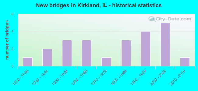
- New bridges - historical statistics
- 11930-1939
- 21940-1949
- 31950-1959
- 31960-1969
- 11970-1979
- 31980-1989
- 41990-1999
- 52000-2009
- 12010-2019


- Bridge Condition - Deck
- 7.1%Very good
- 35.7%Good
- 42.9%Satisfactory
- 7.1%Fair
- 7.1%Poor

- Bridge Condition - Superstructure
- 21.4%Very good
- 28.6%Good
- 21.4%Satisfactory
- 14.3%Fair
- 7.1%Poor
- 7.1%Serious

- Bridge Condition - Substructure
- 35.7%Very good
- 35.7%Good
- 21.4%Satisfactory
- 7.1%Fair

- Bridge Condition - Channel
- 9.1%Very good
- 45.5%Good
- 40.9%Satisfactory
- 4.5%Fair

- Bridge Condition - Culverts
- 22.2%Very good
- 22.2%Good
- 44.4%Satisfactory
- 11.1%Fair
Find on map >> Show street view
Structure Number: 4501, Location: AT DEKALB CO. LINE (Lat: 42.153461, Lng: -88.837872), Route carried "on" structure: County highway , Year Built: 1999, Status: Open, Structure Length: 0.70m (2.30ft), Average Daily Traffic: 525 (year 2018), Truck Traffic: 8%, Average Future Daily Traffic: 475 (year 2040), Design Load: HS 20, Features Intersected: KINGSBURY CREEK, Facility Carried by Structure: PEARL STREET RD
Minimum Vertical Clearance: 30+ m (98+ ft), Kilometerpoint: 9.350, Lanes on structure: 2, Owner: Town or Township Highway Agency, Approaching Roadway Width: 9.1m (29.9ft), Material/Design: Steel, Design/Construction: Culvert, Number Of Spans In Main Unit: 1, Length of Maximum Span: 7.0m (23.0ft)
Condition: Channel: Good, Culverts: Very good, Operating Rating: 44.1 metric tons, Method Used To Determine Operating Rating: Assigned rating based on Load Factor Design (LFD) reported by rating factor (RF) using MS18 loading, Inventory Rating: 32.4 metric tons, Method Used To Determine Inventory Rating: Assigned rating based on Load Factor Design (LFD) reported by rating factor (RF) using MS18 loading, Structural Evaluation: Equal to present desirable criteria, Waterway Adequacy: Equal to present desirable criteria, Approach Roadway Alignment: Better than present minimum criteria, Designated Inspection Frequency: Every 24 months, Inspection Date: March 2020
Find on map >> Show street view
Structure Number: 19003, Location: 1.3 MI W OF KIRKLAND (Lat: 42.088017, Lng: -88.880761), Route carried "on" structure: State highway 72, Year Built: 1982, Status: Open, Structure Length: 5.00m (16.40ft), Average Daily Traffic: 2,350 (year 2021), Truck Traffic: 13%, Average Future Daily Traffic: 3,314 (year 2032), Design Load: HS 20, Features Intersected: OWENS CREEK
Minimum Vertical Clearance: 30+ m (98+ ft), Kilometerpoint: 82.943, Lanes on structure: 2, Base Highway Network: Yes, Owner: State Highway Agency, Approaching Roadway Width: 10.4m (34.1ft), Skew: 4 degrees, Material/Design: Steel continuous, Design/Construction: Stringer/Multi-beam, Number Of Spans In Main Unit: 3, Length of Maximum Span: 17.7m (58.1ft), Curb-To-Curb Width: 9.8m (32.2ft), Out-to-Out Width: 10.2m (33.5ft)
Condition: Deck: Fair, Superstructure: Poor, Substructure: Satisfactory, Channel: Satisfactory, Operating Rating: 51.2 metric tons, Method Used To Determine Operating Rating: Load Factor (LF) rating reported by rating factor (RF) method using MS18 loading, Inventory Rating: 30.5 metric tons, Method Used To Determine Inventory Rating: Load Factor (LF) rating reported by rating factor (RF) method using MS18 loading, Structural Evaluation: Meets minimum limits, Deck Geometry: Meets minimum limits, Waterway Adequacy: Equal to present desirable criteria, Approach Roadway Alignment: Equal to present desirable criteria, Designated Inspection Frequency: Every 12 months, Other Special Inspection Frequency: Every 12 months, Inspection Date: July 2021, Other Special Inspection Date: July 2021, Deck Structure Type: Concrete Cast-file-Place, Wearing Surface/Protective System: Deck Protection: Epoxy Coated Reinforcing
Find on map >> Show street view
Structure Number: 190037, Location: 3 MI NW OF KIRKLAND (Lat: 42.101675, Lng: -88.911503), Route carried "on" structure: State highway 72, Year Built: 1990, Status: Open, Structure Length: 1.68m (5.51ft), Average Daily Traffic: 1,950 (year 2021), Truck Traffic: 13%, Average Future Daily Traffic: 2,832 (year 2032), Design Load: HS 20, Features Intersected: DRAINAGE DITCH
Minimum Vertical Clearance: 30+ m (98+ ft), Kilometerpoint: 79.516, Lanes on structure: 2, Base Highway Network: Yes, Owner: State Highway Agency, Approaching Roadway Width: 10.4m (34.1ft), Skew: 4 degrees, Material/Design: Steel, Design/Construction: Stringer/Multi-beam, Number Of Spans In Main Unit: 1, Length of Maximum Span: 16.2m (53.1ft), Curb-To-Curb Width: 9.7m (31.8ft), Out-to-Out Width: 10.7m (35.1ft)
Condition: Deck: Satisfactory, Superstructure: Fair, Substructure: Very good, Channel: Satisfactory, Operating Rating: 62.2 metric tons, Method Used To Determine Operating Rating: Load Factor (LF) rating reported by rating factor (RF) method using MS18 loading, Inventory Rating: 37.9 metric tons, Method Used To Determine Inventory Rating: Load Factor (LF) rating reported by rating factor (RF) method using MS18 loading, Structural Evaluation: Somewhat better than minimum adequacy, Deck Geometry: Somewhat better than minimum adequacy, Waterway Adequacy: Equal to present desirable criteria, Approach Roadway Alignment: Equal to present desirable criteria, Designated Inspection Frequency: Every 24 months, Inspection Date: March 2021, Deck Structure Type: Concrete Cast-file-Place, Wearing Surface/Protective System: Deck Protection: Epoxy Coated Reinforcing
Find on map >> Show street view
Structure Number: 190038, Location: 0.3 MI. W. KIRKLAND (Lat: 42.087581, Lng: -88.861456), Route carried "on" structure: State highway 72, Year Built: 1991, Status: Open, Structure Length: 1.30m (4.27ft), Average Daily Traffic: 2,350 (year 2021), Truck Traffic: 13%, Average Future Daily Traffic: 3,314 (year 2032), Design Load: HS 20, Features Intersected: UNNAMED CREEK
Minimum Vertical Clearance: 30+ m (98+ ft), Kilometerpoint: 84.569, Lanes on structure: 2, Base Highway Network: Yes, Owner: State Highway Agency, Approaching Roadway Width: 11.0m (36.1ft), Material/Design: Steel, Design/Construction: Stringer/Multi-beam, Number Of Spans In Main Unit: 1, Length of Maximum Span: 11.8m (38.7ft), Curb-To-Curb Width: 9.8m (32.2ft), Out-to-Out Width: 11.0m (36.1ft)
Condition: Deck: Good, Superstructure: Fair, Substructure: Very good, Channel: Good, Operating Rating: 56.7 metric tons, Method Used To Determine Operating Rating: Load Factor (LF) rating reported by rating factor (RF) method using MS18 loading, Inventory Rating: 34.3 metric tons, Method Used To Determine Inventory Rating: Load Factor (LF) rating reported by rating factor (RF) method using MS18 loading, Structural Evaluation: Somewhat better than minimum adequacy, Deck Geometry: Meets minimum limits, Waterway Adequacy: Equal to present desirable criteria, Approach Roadway Alignment: Equal to present desirable criteria, Designated Inspection Frequency: Every 24 months, Inspection Date: March 2021, Deck Structure Type: Concrete Cast-file-Place, Wearing Surface/Protective System: Deck Protection: Epoxy Coated Reinforcing
Find on map >> Show street view
Structure Number: 190047, Location: W EDGE OF KIRKLAND (Lat: 42.098289, Lng: -88.888425), Route carried "on" structure: State highway 72, Year Built: 2006, Status: Open, Structure Length: 4.98m (16.34ft), Average Daily Traffic: 1,950 (year 2021), Truck Traffic: 13%, Average Future Daily Traffic: 2,832 (year 2032), Design Load: HS 20, Features Intersected: SOO LINE/IC & E RR
Minimum Vertical Clearance: 30+ m (98+ ft), Kilometerpoint: 81.608, Lanes on structure: 2, Base Highway Network: Yes, Owner: State Highway Agency, Approaching Roadway Width: 9.8m (32.2ft), Skew: 2 degrees, Material/Design: Steel continuous, Design/Construction: Stringer/Multi-beam, Number Of Spans In Main Unit: 3, Number Of Approach Spans: 2, Length of Maximum Span: 23.4m (76.8ft), Curb-To-Curb Width: 9.8m (32.2ft), Out-to-Out Width: 10.7m (35.1ft)
Condition: Deck: Satisfactory, Superstructure: Very good, Substructure: Very good, Operating Rating: 80.4 metric tons, Method Used To Determine Operating Rating: Load Factor (LF) rating reported by rating factor (RF) method using MS18 loading, Inventory Rating: 48.3 metric tons, Method Used To Determine Inventory Rating: Load Factor (LF) rating reported by rating factor (RF) method using MS18 loading, Structural Evaluation: Equal to present desirable criteria, Deck Geometry: Somewhat better than minimum adequacy, Underclear: Superior to present desirable criteria, Approach Roadway Alignment: Equal to present desirable criteria, Designated Inspection Frequency: Every 48 months, Inspection Date: March 2019, Deck Structure Type: Concrete Cast-file-Place, Wearing Surface/Protective System: Deck Protection: Epoxy Coated Reinforcing
Find on map >> Show street view
Structure Number: 192014, Location: IN KIRKLAND (Lat: 42.092100, Lng: -88.853411), Route carried "on" structure: State highway 72, Year Built: 1994, Status: Open, Structure Length: 1.22m (4.00ft), Average Daily Traffic: 2,350 (year 2021), Truck Traffic: 13%, Average Future Daily Traffic: 3,314 (year 2032), Design Load: HS 20, Features Intersected: BULL RUN CREEK
Minimum Vertical Clearance: 30+ m (98+ ft), Kilometerpoint: 85.406, Lanes on structure: 2, Base Highway Network: Yes, Owner: State Highway Agency, Approaching Roadway Width: 10.1m (33.1ft), Skew: 2 degrees, Material/Design: Concrete, Design/Construction: Culvert, Number Of Spans In Main Unit: 3, Length of Maximum Span: 4.0m (13.1ft), Curb-To-Curb Width: 10.1m (33.1ft), Out-to-Out Width: 11.0m (36.1ft)
Condition: Channel: Fair, Culverts: Very good, Operating Rating: 57.7 metric tons, Method Used To Determine Operating Rating: Load Factor (LF) rating reported by rating factor (RF) method using MS18 loading, Inventory Rating: 34.3 metric tons, Method Used To Determine Inventory Rating: Load Factor (LF) rating reported by rating factor (RF) method using MS18 loading, Structural Evaluation: Equal to present desirable criteria, Deck Geometry: Meets minimum limits, Waterway Adequacy: Equal to present desirable criteria, Approach Roadway Alignment: Equal to present desirable criteria, Designated Inspection Frequency: Every 48 months, Inspection Date: March 2019, Deck Structure Type: Concrete Cast-file-Place, Wearing Surface/Protective System: Wearing Surface: Bituminous, Deck Protection: Epoxy Coated Reinforcing
Find on map >> Show street view
Structure Number: 193023, Location: 3290N 490E (Lat: 42.107608, Lng: -88.851642), Route carried "on" structure: County highway , Year Built: 1938, Status: Open, Structure Length: 1.01m (3.31ft), Average Daily Traffic: 575 (year 2021), Truck Traffic: 6%, Average Future Daily Traffic: 783 (year 2032), Features Intersected: PR SO BR KISHWAUKEE, Facility Carried by Structure: KIRKLAND RD
Minimum Vertical Clearance: 30+ m (98+ ft), Kilometerpoint: 6.952, Lanes on structure: 2, Owner: County Highway Agency, Approaching Roadway Width: 9.1m (29.9ft), Skew: 4 degrees, Material/Design: Concrete, Design/Construction: Culvert, Number Of Spans In Main Unit: 2, Length of Maximum Span: 4.5m (14.8ft)
Condition: Channel: Satisfactory, Culverts: Fair, Operating Rating: 26.9 metric tons, Method Used To Determine Operating Rating: Load Factor (LF) rating reported by rating factor (RF) method using MS18 loading, Inventory Rating: 16.2 metric tons, Method Used To Determine Inventory Rating: Load Factor (LF) rating reported by rating factor (RF) method using MS18 loading, Structural Evaluation: Meets minimum limits, Waterway Adequacy: Better than present minimum criteria, Approach Roadway Alignment: Equal to present desirable criteria, Designated Inspection Frequency: Every 24 months, Inspection Date: Febuary 2020
Find on map >> Show street view
Structure Number: 19304, Location: 3210N 490E (Lat: 42.097275, Lng: -88.851397), Route carried "on" structure: County highway , Year Built: 1980, Year Reconstructed: 2005, Status: Open, Structure Length: 7.44m (24.41ft), Average Daily Traffic: 575 (year 2021), Truck Traffic: 6%, Average Future Daily Traffic: 783 (year 2032), Design Load: HS 20, Features Intersected: S BR KISHWAUKEE RV, Facility Carried by Structure: KIRKLAND ROAD
Minimum Vertical Clearance: 30+ m (98+ ft), Kilometerpoint: 8.111, Lanes on structure: 2, Owner: County Highway Agency, Approaching Roadway Width: 9.1m (29.9ft), Skew: 4 degrees, Material/Design: Steel continuous, Design/Construction: Stringer/Multi-beam, Number Of Spans In Main Unit: 5, Length of Maximum Span: 14.8m (48.6ft), Curb-To-Curb Width: 9.8m (32.2ft), Out-to-Out Width: 9.8m (32.2ft)
Condition: Deck: Satisfactory, Superstructure: Good, Substructure: Good, Channel: Good, Operating Rating: 40.8 metric tons, Method Used To Determine Operating Rating: Load Factor (LF) rating reported by rating factor (RF) method using MS18 loading, Inventory Rating: 25.3 metric tons, Method Used To Determine Inventory Rating: Load Factor (LF) rating reported by rating factor (RF) method using MS18 loading, Structural Evaluation: Equal to present minimum criteria, Deck Geometry: Equal to present minimum criteria, Waterway Adequacy: Superior to present desirable criteria, Approach Roadway Alignment: Equal to present desirable criteria, Length Of Structure Improvement: 7.44m (24.41ft), Designated Inspection Frequency: Every 24 months, Inspection Date: April 2020, Bridge Improvement Cost: $430,000, Roadway Improvement Cost: $43,000, Total Project Cost: $645,000, Deck Structure Type: Concrete Cast-file-Place
Find on map >> Show street view
Structure Number: 193057, Location: 3500N 380E (Lat: 42.138408, Lng: -88.872775), Route carried "on" structure: County highway , Year Built: 2001, Status: Open, Structure Length: 1.85m (6.07ft), Average Daily Traffic: 225 (year 2021), Truck Traffic: 9%, Average Future Daily Traffic: 301 (year 2032), Design Load: HS 20, Features Intersected: KINGSBURY CREEK, Facility Carried by Structure: KIRKLAND ROAD
Minimum Vertical Clearance: 30+ m (98+ ft), Kilometerpoint: 1.819, Lanes on structure: 2, Owner: County Highway Agency, Approaching Roadway Width: 8.2m (26.9ft), Material/Design: Prestressed concrete, Design/Construction: Box Beam or Girders - Multiple, Number Of Spans In Main Unit: 2, Length of Maximum Span: 8.7m (28.5ft), Curb-To-Curb Width: 9.1m (29.9ft), Out-to-Out Width: 9.8m (32.2ft)
Condition: Deck: Good, Superstructure: Good, Substructure: Very good, Channel: Satisfactory, Operating Rating: 44.1 metric tons, Method Used To Determine Operating Rating: Assigned rating based on Load Factor Design (LFD) reported by rating factor (RF) using MS18 loading, Inventory Rating: 32.4 metric tons, Method Used To Determine Inventory Rating: Assigned rating based on Load Factor Design (LFD) reported by rating factor (RF) using MS18 loading, Structural Evaluation: Better than present minimum criteria, Deck Geometry: Equal to present minimum criteria, Waterway Adequacy: Better than present minimum criteria, Approach Roadway Alignment: Equal to present desirable criteria, Designated Inspection Frequency: Every 48 months, Inspection Date: April 2018, Deck Structure Type: Concrete Precast Panels, Wearing Surface/Protective System: Wearing Surface: Bituminous, Membrane: Built-up, Deck Protection: Other
Find on map >> Show street view
Structure Number: 193061, Location: 3560N 430E (Lat: 42.147328, Lng: -88.864144), Route carried "on" structure: County highway , Year Built: 2008, Status: Open, Structure Length: 1.33m (4.36ft), Average Daily Traffic: 2,950 (year 2021), Truck Traffic: 11%, Average Future Daily Traffic: 4,700 (year 2032), Design Load: HS 20, Features Intersected: KINGSBURY CREEK, Facility Carried by Structure: CHERRY VALLEY RD
Minimum Vertical Clearance: 30+ m (98+ ft), Kilometerpoint: 0.724, Lanes on structure: 2, Owner: County Highway Agency, Approaching Roadway Width: 13.4m (44.0ft), Material/Design: Concrete, Design/Construction: Slab, Number Of Spans In Main Unit: 1, Length of Maximum Span: 12.3m (40.4ft), Curb-To-Curb Width: 14.0m (45.9ft), Out-to-Out Width: 14.0m (45.9ft)
Condition: Deck: Satisfactory, Superstructure: Satisfactory, Substructure: Good, Channel: Good, Operating Rating: 44.1 metric tons, Method Used To Determine Operating Rating: Assigned rating based on Load Factor Design (LFD) reported by rating factor (RF) using MS18 loading, Inventory Rating: 32.4 metric tons, Method Used To Determine Inventory Rating: Assigned rating based on Load Factor Design (LFD) reported by rating factor (RF) using MS18 loading, Structural Evaluation: Equal to present minimum criteria, Deck Geometry: Superior to present desirable criteria, Waterway Adequacy: Superior to present desirable criteria, Approach Roadway Alignment: Equal to present desirable criteria, Designated Inspection Frequency: Every 24 months, Inspection Date: April 2020, Deck Structure Type: Concrete Cast-file-Place, Wearing Surface/Protective System: Deck Protection: Epoxy Coated Reinforcing
Find on map >> Show street view
Structure Number: 193073, Location: 2785 N 385 E (Lat: 42.035378, Lng: -88.871911), Route carried "on" structure: County highway , Year Built: 2011, Status: Open, Structure Length: 3.76m (12.34ft), Average Daily Traffic: 1,050 (year 2021), Truck Traffic: 7%, Average Future Daily Traffic: 1,386 (year 2032), Design Load: HS 25 or greater, Features Intersected: OWENS CREEK, Facility Carried by Structure: OLD STATE ROAD
Minimum Vertical Clearance: 30+ m (98+ ft), Kilometerpoint: 7.692, Lanes on structure: 2, Owner: County Highway Agency, Approaching Roadway Width: 9.8m (32.2ft), Material/Design: Steel continuous, Design/Construction: Stringer/Multi-beam, Number Of Spans In Main Unit: 3, Length of Maximum Span: 14.3m (46.9ft), Curb-To-Curb Width: 9.8m (32.2ft), Out-to-Out Width: 9.8m (32.2ft)
Condition: Deck: Good, Superstructure: Very good, Substructure: Very good, Channel: Very good, Operating Rating: 44.1 metric tons, Method Used To Determine Operating Rating: Assigned rating based on Load Factor Design (LFD) reported by rating factor (RF) using MS18 loading, Inventory Rating: 32.4 metric tons, Method Used To Determine Inventory Rating: Assigned rating based on Load Factor Design (LFD) reported by rating factor (RF) using MS18 loading, Structural Evaluation: Equal to present desirable criteria, Deck Geometry: Somewhat better than minimum adequacy, Waterway Adequacy: Superior to present desirable criteria, Approach Roadway Alignment: Equal to present desirable criteria, Designated Inspection Frequency: Every 48 months, Inspection Date: September 2021, Deck Structure Type: Concrete Cast-file-Place, Wearing Surface/Protective System: Deck Protection: Epoxy Coated Reinforcing
Find on map >> Show street view
Structure Number: 194002, Location: 3150N 490E (Lat: 42.087650, Lng: -88.851828), Route carried "on" structure: City street , Year Built: 1969, Year Reconstructed: 2012, Status: Open, Structure Length: 1.35m (4.43ft), Average Daily Traffic: 400 (year 2021), Truck Traffic: 35%, Average Future Daily Traffic: 723 (year 2032), Design Load: HS 25 or greater, Features Intersected: BULL RUN, Facility Carried by Structure: HORTENSE ST
Minimum Vertical Clearance: 30+ m (98+ ft), Kilometerpoint: 0.370, Lanes on structure: 2, Owner: City or Municipal Highway Agency, Approaching Roadway Width: 7.0m (23.0ft), Material/Design: Prestressed concrete, Design/Construction: Box Beam or Girders - Multiple, Number Of Spans In Main Unit: 1, Length of Maximum Span: 12.7m (41.7ft), Curb-To-Curb Width: 9.8m (32.2ft), Out-to-Out Width: 9.8m (32.2ft)
Condition: Deck: Very good, Superstructure: Very good, Substructure: Good, Channel: Good, Operating Rating: 53.8 metric tons, Method Used To Determine Operating Rating: Load and Resistance Factor Rating (LRFR) rating reported by rating factor(RF) method using HL-93 loadings, Inventory Rating: 41.5 metric tons, Method Used To Determine Inventory Rating: Load and Resistance Factor Rating (LRFR) rating reported by rating factor(RF) method using HL-93 loadings, Structural Evaluation: Better than present minimum criteria, Deck Geometry: Better than present minimum criteria, Waterway Adequacy: Equal to present desirable criteria, Approach Roadway Alignment: Equal to present desirable criteria, Designated Inspection Frequency: Every 48 months, Inspection Date: December 2020, Deck Structure Type: Concrete Precast Panels, Wearing Surface/Protective System: Wearing Surface: Bituminous, Membrane: Built-up, Deck Protection: Epoxy Coated Reinforcing
Find on map >> Show street view
Structure Number: 194003, Location: 3000N 365E (Lat: 42.065706, Lng: -88.875622), Route carried "on" structure: County highway , Year Built: 1966, Year Reconstructed: 2000, Status: Posted for load, Structure Length: 2.88m (9.45ft), Average Daily Traffic: 300 (year 2021), Truck Traffic: 40%, Average Future Daily Traffic: 392 (year 2032), Design Load: HS 20, Features Intersected: OWEN CREEK, Facility Carried by Structure: BASE LINE RD
Minimum Vertical Clearance: 30+ m (98+ ft), Kilometerpoint: 5.649, Lanes on structure: 2, Owner: Town or Township Highway Agency, Approaching Roadway Width: 7.6m (24.9ft), Material/Design: Prestressed concrete, Design/Construction: Box Beam or Girders - Multiple, Number Of Spans In Main Unit: 3, Length of Maximum Span: 9.5m (31.2ft), Curb-To-Curb Width: 9.1m (29.9ft), Out-to-Out Width: 9.1m (29.9ft)
Condition: Deck: Good, Superstructure: Good, Substructure: Satisfactory, Channel: Very good, Operating Rating: 44.4 metric tons, Method Used To Determine Operating Rating: Load Factor (LF) rating reported by rating factor (RF) method using MS18 loading, Inventory Rating: 32.4 metric tons, Method Used To Determine Inventory Rating: Load Factor (LF) rating reported by rating factor (RF) method using MS18 loading, Structural Evaluation: Equal to present minimum criteria, Deck Geometry: Equal to present minimum criteria, Waterway Adequacy: Superior to present desirable criteria, Approach Roadway Alignment: Equal to present desirable criteria, Length Of Structure Improvement: 2.90m (9.51ft), Designated Inspection Frequency: Every 24 months, Inspection Date: April 2020, Bridge Improvement Cost: $151,000, Roadway Improvement Cost: $15,000, Total Project Cost: $227,000, Deck Structure Type: Concrete Precast Panels, Wearing Surface/Protective System: Wearing Surface: Bituminous, Membrane: Built-up, Deck Protection: Other
Find on map >> Show street view
Structure Number: 194005, Location: 3575N 240E (Lat: 42.149061, Lng: -88.900661), Route carried "on" structure: County highway , Year Built: 1948, Status: Open, Structure Length: 0.73m (2.40ft), Average Daily Traffic: 525 (year 2021), Truck Traffic: 44%, Average Future Daily Traffic: 603 (year 2032), Features Intersected: TRIMBLE RUN, Facility Carried by Structure: IRENE RD
Minimum Vertical Clearance: 30+ m (98+ ft), Kilometerpoint: 0.402, Lanes on structure: 2, Owner: Town or Township Highway Agency, Approaching Roadway Width: 8.5m (27.9ft), Material/Design: Concrete, Design/Construction: Culvert, Number Of Spans In Main Unit: 2, Length of Maximum Span: 3.4m (11.2ft)
Condition: Channel: Good, Culverts: Satisfactory, Operating Rating: 29.8 metric tons, Method Used To Determine Operating Rating: Load Factor (LF) rating reported by rating factor (RF) method using MS18 loading, Inventory Rating: 17.8 metric tons, Method Used To Determine Inventory Rating: Load Factor (LF) rating reported by rating factor (RF) method using MS18 loading, Structural Evaluation: Meets minimum limits, Waterway Adequacy: Superior to present desirable criteria, Approach Roadway Alignment: Equal to present desirable criteria, Designated Inspection Frequency: Every 24 months, Inspection Date: Febuary 2020
Find on map >> Show street view
Structure Number: 194006, Location: 3500N 240E (Lat: 42.138378, Lng: -88.900678), Route carried "on" structure: County highway , Year Built: 1955, Status: Open, Structure Length: 0.99m (3.25ft), Average Daily Traffic: 525 (year 2021), Truck Traffic: 44%, Average Future Daily Traffic: 603 (year 2032), Design Load: HS 15, Features Intersected: TRIMBLE RUN, Facility Carried by Structure: IRENE RD
Minimum Vertical Clearance: 30+ m (98+ ft), Kilometerpoint: 1.593, Lanes on structure: 2, Owner: Town or Township Highway Agency, Approaching Roadway Width: 7.3m (24.0ft), Material/Design: Concrete, Design/Construction: Slab, Number Of Spans In Main Unit: 1, Length of Maximum Span: 9.4m (30.8ft), Curb-To-Curb Width: 7.3m (24.0ft), Out-to-Out Width: 8.6m (28.2ft)
Condition: Deck: Satisfactory, Superstructure: Satisfactory, Substructure: Good, Channel: Good, Operating Rating: 45.7 metric tons, Method Used To Determine Operating Rating: Load Factor (LF) rating reported by rating factor (RF) method using MS18 loading, Inventory Rating: 27.2 metric tons, Method Used To Determine Inventory Rating: Load Factor (LF) rating reported by rating factor (RF) method using MS18 loading, Structural Evaluation: Equal to present minimum criteria, Deck Geometry: Meets minimum limits, Waterway Adequacy: Better than present minimum criteria, Approach Roadway Alignment: Equal to present desirable criteria, Designated Inspection Frequency: Every 24 months, Inspection Date: March 2020, Deck Structure Type: Concrete Cast-file-Place, Wearing Surface/Protective System: Wearing Surface: Bituminous
Find on map >> Show street view
Structure Number: 194008, Location: 3215N 540E (Lat: 42.097694, Lng: -88.841781), Route carried "on" structure: City street , Year Built: 1949, Status: Posted for load, Structure Length: 6.82m (22.38ft), Average Daily Traffic: 1,000 (year 2021), Truck Traffic: 31%, Average Future Daily Traffic: 1,446 (year 2032), Design Load: H 15, Features Intersected: SO BR KISHWAUKEE RV, Facility Carried by Structure: PEARL ST
Minimum Vertical Clearance: 30+ m (98+ ft), Kilometerpoint: 0.080, Lanes on structure: 2, Owner: City or Municipal Highway Agency, Approaching Roadway Width: 8.5m (27.9ft), Material/Design: Steel continuous, Design/Construction: Stringer/Multi-beam, Number Of Spans In Main Unit: 4, Length of Maximum Span: 18.6m (61.0ft), Curb-To-Curb Width: 6.6m (21.7ft), Out-to-Out Width: 7.3m (24.0ft)
Condition: Deck: Poor, Superstructure: Serious, Substructure: Satisfactory, Channel: Satisfactory, Operating Rating: 32.7 metric tons, Method Used To Determine Operating Rating: Load Factor (LF) rating reported by rating factor (RF) method using MS18 loading, Inventory Rating: 19.4 metric tons, Method Used To Determine Inventory Rating: Load Factor (LF) rating reported by rating factor (RF) method using MS18 loading, Structural Evaluation: High priority of corrective action, Deck Geometry: High priority of corrective action, Waterway Adequacy: Superior to present desirable criteria, Approach Roadway Alignment: Equal to present desirable criteria, Bridge Posting: Required (Relationship of Operating Rating to Maximum Legal Load: > 39.9% below), Designated Inspection Frequency: Every 24 months, Inspection Date: March 2020, Deck Structure Type: Concrete Cast-file-Place
Find on map >> Show street view
Structure Number: 19401, Location: 3070N 540E (Lat: 42.075772, Lng: -88.841439), Route carried "on" structure: County highway , Year Built: 1963, Status: Open, Structure Length: 0.74m (2.43ft), Average Daily Traffic: 1,050 (year 2021), Truck Traffic: 35%, Average Future Daily Traffic: 1,687 (year 2032), Design Load: HS 20, Features Intersected: BULL RUN CREEK, Facility Carried by Structure: PEARL STREET
Minimum Vertical Clearance: 30+ m (98+ ft), Kilometerpoint: 0.531, Lanes on structure: 2, Owner: Town or Township Highway Agency, Approaching Roadway Width: 8.2m (26.9ft), Skew: 4 degrees, Material/Design: Concrete, Design/Construction: Culvert, Number Of Spans In Main Unit: 2, Length of Maximum Span: 3.6m (11.8ft)
Condition: Channel: Satisfactory, Culverts: Satisfactory, Operating Rating: 56.4 metric tons, Method Used To Determine Operating Rating: Load Factor (LF) rating reported by rating factor (RF) method using MS18 loading, Inventory Rating: 33.7 metric tons, Method Used To Determine Inventory Rating: Load Factor (LF) rating reported by rating factor (RF) method using MS18 loading, Structural Evaluation: Equal to present minimum criteria, Waterway Adequacy: Equal to present desirable criteria, Approach Roadway Alignment: Superior to present desirable criteria, Designated Inspection Frequency: Every 24 months, Inspection Date: Febuary 2020
Find on map >> Show street view
Structure Number: 194013, Location: 3400N 175E (Lat: 42.123450, Lng: -88.913283), Route carried "on" structure: County highway , Year Built: 1984, Status: Open, Structure Length: 0.69m (2.26ft), Average Daily Traffic: 100 (year 2021), Truck Traffic: 26%, Average Future Daily Traffic: 181 (year 2032), Design Load: HS 20, Features Intersected: BR OF KISHWAUKEE RV, Facility Carried by Structure: WHEELER ROAD
Minimum Vertical Clearance: 30+ m (98+ ft), Kilometerpoint: 3.750, Lanes on structure: 2, Owner: Town or Township Highway Agency, Approaching Roadway Width: 7.9m (25.9ft), Skew: 4 degrees, Material/Design: Concrete, Design/Construction: Culvert, Number Of Spans In Main Unit: 2, Length of Maximum Span: 3.0m (9.8ft)
Condition: Channel: Satisfactory, Culverts: Good, Operating Rating: 44.4 metric tons, Method Used To Determine Operating Rating: Assigned rating based on Load Factor Design (LFD) reported by rating factor (RF) using MS18 loading, Inventory Rating: 32.4 metric tons, Method Used To Determine Inventory Rating: Assigned rating based on Load Factor Design (LFD) reported by rating factor (RF) using MS18 loading, Structural Evaluation: Better than present minimum criteria, Waterway Adequacy: Equal to present desirable criteria, Approach Roadway Alignment: Equal to present desirable criteria, Designated Inspection Frequency: Every 48 months, Inspection Date: April 2018
Find on map >> Show street view
Structure Number: 194014, Location: 3310 N 240 E (Lat: 42.110081, Lng: -88.900569), Route carried "on" structure: County highway , Year Built: 2004, Status: Open, Structure Length: 8.10m (26.57ft), Average Daily Traffic: 625 (year 2021), Truck Traffic: 48%, Average Future Daily Traffic: 663 (year 2032), Design Load: HS 20, Features Intersected: S BR KISHWAUKEE RIV., Facility Carried by Structure: IRENE RD
Minimum Vertical Clearance: 30+ m (98+ ft), Kilometerpoint: 4.764, Lanes on structure: 2, Owner: Town or Township Highway Agency, Approaching Roadway Width: 9.1m (29.9ft), Skew: 2 degrees, Material/Design: Prestressed concrete, Design/Construction: Stringer/Multi-beam, Number Of Spans In Main Unit: 4, Length of Maximum Span: 19.9m (65.3ft), Curb-To-Curb Width: 9.1m (29.9ft), Out-to-Out Width: 9.1m (29.9ft)
Condition: Deck: Good, Superstructure: Good, Substructure: Good, Channel: Good, Operating Rating: 44.1 metric tons, Method Used To Determine Operating Rating: Assigned rating based on Load Factor Design (LFD) reported by rating factor (RF) using MS18 loading, Inventory Rating: 32.4 metric tons, Method Used To Determine Inventory Rating: Assigned rating based on Load Factor Design (LFD) reported by rating factor (RF) using MS18 loading, Structural Evaluation: Better than present minimum criteria, Deck Geometry: Equal to present minimum criteria, Waterway Adequacy: Better than present minimum criteria, Approach Roadway Alignment: Equal to present desirable criteria, Designated Inspection Frequency: Every 48 months, Inspection Date: April 2018, Deck Structure Type: Concrete Cast-file-Place
Find on map >> Show street view
Structure Number: 194015, Location: 1 MI NW OF KIRKLAND (Lat: 42.112919, Lng: -88.871658), Route carried "on" structure: County highway , Year Built: 2004, Status: Open, Structure Length: 1.80m (5.91ft), Average Daily Traffic: 200 (year 2021), Truck Traffic: 42%, Average Future Daily Traffic: 422 (year 2032), Design Load: HS 20, Features Intersected: KINGSBURY CREEK, Facility Carried by Structure: SCOUT RD
Minimum Vertical Clearance: 30+ m (98+ ft), Kilometerpoint: 2.366, Lanes on structure: 2, Owner: Town or Township Highway Agency, Approaching Roadway Width: 7.6m (24.9ft), Skew: 2 degrees, Material/Design: Concrete, Design/Construction: Culvert, Number Of Spans In Main Unit: 4, Length of Maximum Span: 4.8m (15.7ft)
Condition: Channel: Good, Culverts: Good, Operating Rating: 44.1 metric tons, Method Used To Determine Operating Rating: Assigned rating based on Load Factor Design (LFD) reported by rating factor (RF) using MS18 loading, Inventory Rating: 32.4 metric tons, Method Used To Determine Inventory Rating: Assigned rating based on Load Factor Design (LFD) reported by rating factor (RF) using MS18 loading, Structural Evaluation: Better than present minimum criteria, Waterway Adequacy: Better than present minimum criteria, Approach Roadway Alignment: Equal to present desirable criteria, Designated Inspection Frequency: Every 48 months, Inspection Date: April 2018
Find on map >> Show street view
Structure Number: 194301, Location: 2750N 425E (Lat: 42.028689, Lng: -88.863697), Route carried "on" structure: County highway , Year Built: 1970, Status: Open, Structure Length: 2.80m (9.19ft), Average Daily Traffic: 50 (year 2021), Average Future Daily Traffic: 60 (year 2032), Design Load: HS 20, Features Intersected: OWENS CREEK, Facility Carried by Structure: SCHAFER RD
Minimum Vertical Clearance: 30+ m (98+ ft), Kilometerpoint: 0.724, Lanes on structure: 2, Owner: Town or Township Highway Agency, Approaching Roadway Width: 6.1m (20.0ft), Skew: 2 degrees, Material/Design: Concrete, Design/Construction: Channel Beam, Number Of Spans In Main Unit: 3, Length of Maximum Span: 9.1m (29.9ft), Curb-To-Curb Width: 8.5m (27.9ft), Out-to-Out Width: 9.1m (29.9ft)
Condition: Deck: Satisfactory, Superstructure: Satisfactory, Substructure: Fair, Channel: Satisfactory, Operating Rating: 44.4 metric tons, Method Used To Determine Operating Rating: Allowable Stress (AS) rating reported by rating factor (RF) method using MS18 loading, Inventory Rating: 32.4 metric tons, Method Used To Determine Inventory Rating: Allowable Stress (AS) rating reported by rating factor (RF) method using MS18 loading, Structural Evaluation: Somewhat better than minimum adequacy, Deck Geometry: Better than present minimum criteria, Waterway Adequacy: Superior to present desirable criteria, Approach Roadway Alignment: Equal to present desirable criteria, Designated Inspection Frequency: Every 24 months, Inspection Date: March 2020, Deck Structure Type: Concrete Precast Panels
Find on map >> Show street view
Structure Number: 194302, Location: 2990N 300E (Lat: 42.064117, Lng: -88.888303), Route carried "on" structure: County highway , Year Built: 1950, Status: Open, Structure Length: 0.69m (2.26ft), Average Daily Traffic: 25 (year 2021), Average Future Daily Traffic: 30 (year 2032), Features Intersected: BRANCH OF OWENS CR, Facility Carried by Structure: BARCHARD ROAD
Minimum Vertical Clearance: 30+ m (98+ ft), Kilometerpoint: 0.161, Lanes on structure: 2, Owner: Town or Township Highway Agency, Approaching Roadway Width: 6.7m (22.0ft), Skew: 3 degrees, Material/Design: Concrete, Design/Construction: Culvert, Number Of Spans In Main Unit: 2, Length of Maximum Span: 3.0m (9.8ft)
Condition: Channel: Good, Culverts: Satisfactory, Operating Rating: 23.3 metric tons, Method Used To Determine Operating Rating: Load Factor (LF) rating reported by rating factor (RF) method using MS18 loading, Inventory Rating: 13.9 metric tons, Method Used To Determine Inventory Rating: Load Factor (LF) rating reported by rating factor (RF) method using MS18 loading, Structural Evaluation: Meets minimum limits, Waterway Adequacy: Better than present minimum criteria, Approach Roadway Alignment: Equal to present desirable criteria, Designated Inspection Frequency: Every 24 months, Inspection Date: Febuary 2020
Find on map >> Show street view
Structure Number: 194403, Location: 2875N 750E (Lat: 42.049242, Lng: -88.802961), Route carried "on" structure: County highway , Year Built: 1955, Status: Open, Structure Length: 0.80m (2.62ft), Average Daily Traffic: 75 (year 2021), Average Future Daily Traffic: 331 (year 2032), Design Load: HS 15, Features Intersected: LEE SLOUGH CREEK, Facility Carried by Structure: TR-116 (JOHNSON RD
Minimum Vertical Clearance: 30+ m (98+ ft), Kilometerpoint: 1.899, Lanes on structure: 2, Owner: Town or Township Highway Agency, Approaching Roadway Width: 6.1m (20.0ft), Material/Design: Concrete continuous, Design/Construction: Culvert, Number Of Spans In Main Unit: 3, Length of Maximum Span: 2.6m (8.5ft)
Condition: Channel: Satisfactory, Culverts: Satisfactory, Operating Rating: 50.9 metric tons, Method Used To Determine Operating Rating: Load and Resistance Factor Rating (LRFR) rating reported by rating factor(RF) method using HL-93 loadings, Inventory Rating: 39.2 metric tons, Method Used To Determine Inventory Rating: Load and Resistance Factor Rating (LRFR) rating reported by rating factor(RF) method using HL-93 loadings, Structural Evaluation: Equal to present minimum criteria, Waterway Adequacy: Superior to present desirable criteria, Approach Roadway Alignment: Equal to present desirable criteria, Designated Inspection Frequency: Every 24 months, Inspection Date: Febuary 2020