Bridge Statistics for Kinmundy, Illinois (IL)
Condition, Traffic, Stress, Structural Evaluation, Project Costs
- National Bridge Inventory (NBI) Statistics
- 21Number of bridges
- 167ft / 50.9mTotal length
- $103,000Total costs
- 182,850Total average daily traffic
- 65,898Total average daily truck traffic
- National Bridge Inventory (NBI) Registered Bridges for Kinmundy
- No street view available for this location
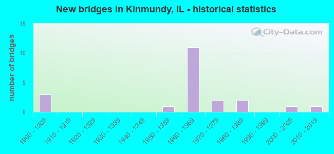
- New bridges - historical statistics
- 31900-1909
- 11950-1959
- 111960-1969
- 21970-1979
- 21980-1989
- 12000-2009
- 12010-2019


- Bridge Condition - Deck
- 18.2%Very good
- 54.5%Good
- 18.2%Satisfactory
- 9.1%Fair

- Bridge Condition - Superstructure
- 45.5%Very good
- 36.4%Good
- 18.2%Satisfactory

- Bridge Condition - Substructure
- 18.2%Very good
- 72.7%Good
- 9.1%Poor

- Bridge Condition - Channel
- 16.7%Very good
- 16.7%Good
- 41.7%Satisfactory
- 25.0%Fair

- Bridge Condition - Culverts
- 83.3%Good
- 16.7%Satisfactory
Find on map >> Show street view
Structure Number: 61001, Location: KINMUNDY INT (Lat: 38.758761, Lng: -88.893281), Route carried "on" structure: County highway , Year Built: 1968, Status: Open, Structure Length: 8.14m (26.71ft), Average Daily Traffic: 1,000 (year 2017), Truck Traffic: 15%, Average Future Daily Traffic: 1,219 (year 2032), Design Load: HS 20, Features Intersected: FAI-57, Facility Carried by Structure: KINOKA RD (FAS 271
Minimum Vertical Clearance: 30+ m (98+ ft), Kilometerpoint: 17.397, Lanes on structure: 2, Lanes under structure: 4, Owner: State Highway Agency, Approaching Roadway Width: 16.5m (54.1ft), Skew: 33 degrees, Material/Design: Steel continuous, Design/Construction: Stringer/Multi-beam, Number Of Spans In Main Unit: 4, Length of Maximum Span: 25.0m (82.0ft), Curb-To-Curb Width: 16.6m (54.5ft), Out-to-Out Width: 17.6m (57.7ft)
Condition: Deck: Good, Superstructure: Satisfactory, Substructure: Good, Operating Rating: 49.6 metric tons, Method Used To Determine Operating Rating: Allowable Stress (AS) rating reported by rating factor (RF) method using MS18 loading, Inventory Rating: 32.4 metric tons, Method Used To Determine Inventory Rating: Allowable Stress (AS) rating reported by rating factor (RF) method using MS18 loading, Structural Evaluation: Equal to present minimum criteria, Deck Geometry: Superior to present desirable criteria, Underclear: High priority of corrective action, Approach Roadway Alignment: Equal to present desirable criteria, Designated Inspection Frequency: Every 24 months, Inspection Date: August 2021, Deck Structure Type: Concrete Cast-file-Place, Wearing Surface/Protective System: Wearing Surface: Other
Find on map >> Show street view
Structure Number: 610058, Location: 2 MI N PATOKA INT (Lat: 38.778581, Lng: -88.872750), Route carried "on" structure: County highway , Year Built: 1969, Status: Open, Structure Length: 6.94m (22.77ft), Average Daily Traffic: 325 (year 2017), Truck Traffic: 15%, Average Future Daily Traffic: 229 (year 2032), Design Load: HS 15, Features Intersected: FAI-57, Facility Carried by Structure: ROBB ROAD (TR 45)
Minimum Vertical Clearance: 30+ m (98+ ft), Kilometerpoint: 4.072, Lanes on structure: 2, Lanes under structure: 4, Owner: State Highway Agency, Approaching Roadway Width: 6.7m (22.0ft), Material/Design: Steel continuous, Design/Construction: Stringer/Multi-beam, Number Of Spans In Main Unit: 4, Length of Maximum Span: 21.3m (69.9ft), Curb-To-Curb Width: 8.0m (26.2ft), Out-to-Out Width: 9.1m (29.9ft)
Condition: Deck: Good, Superstructure: Very good, Substructure: Good, Operating Rating: 46.0 metric tons, Method Used To Determine Operating Rating: Allowable Stress (AS) rating reported by rating factor (RF) method using MS18 loading, Inventory Rating: 27.2 metric tons, Method Used To Determine Inventory Rating: Allowable Stress (AS) rating reported by rating factor (RF) method using MS18 loading, Structural Evaluation: Equal to present minimum criteria, Deck Geometry: Somewhat better than minimum adequacy, Underclear: Meets minimum limits, Approach Roadway Alignment: Equal to present desirable criteria, Designated Inspection Frequency: Every 24 months, Inspection Date: August 2021, Deck Structure Type: Concrete Cast-file-Place
Find on map >> Show street view
Structure Number: 610059, Location: 3.5 MI S FAYETTE C L (Lat: 38.786708, Lng: -88.854894), Route carried "on" structure: Interstate 57, Year Built: 1970, Status: Open, Structure Length: 4.91m (16.11ft), Average Daily Traffic: 12,550 (year 2021), Truck Traffic: 37%, Average Future Daily Traffic: 7,671 (year 2032), Design Load: HS 20+Mod, Features Intersected: UN PACF RR
Minimum Vertical Clearance: 30+ m (98+ ft), Kilometerpoint: 209.322, Lanes on structure: 2, Base Highway Network: Yes, Owner: State Highway Agency, Approaching Roadway Width: 13.4m (44.0ft), Skew: 2 degrees, Material/Design: Steel continuous, Design/Construction: Stringer/Multi-beam, Number Of Spans In Main Unit: 3, Length of Maximum Span: 17.4m (57.1ft), Curb-To-Curb Width: 11.9m (39.0ft), Out-to-Out Width: 13.1m (43.0ft)
Condition: Deck: Satisfactory, Superstructure: Good, Substructure: Good, Operating Rating: 70.6 metric tons, Method Used To Determine Operating Rating: Load Factor (LF) rating reported by rating factor (RF) method using MS18 loading, Inventory Rating: 42.4 metric tons, Method Used To Determine Inventory Rating: Load Factor (LF) rating reported by rating factor (RF) method using MS18 loading, Structural Evaluation: Better than present minimum criteria, Deck Geometry: Equal to present minimum criteria, Underclear: Equal to present minimum criteria, Approach Roadway Alignment: Equal to present desirable criteria, Designated Inspection Frequency: Every 24 months, Inspection Date: August 2021, Deck Structure Type: Concrete Cast-file-Place, Wearing Surface/Protective System: Wearing Surface: Other
Find on map >> Show street view
Structure Number: 61006, Location: 3.5 MI S FAYETTE C L (Lat: 38.786769, Lng: -88.854739), Route carried "on" structure: Interstate 57, Year Built: 1969, Status: Open, Structure Length: 4.91m (16.11ft), Average Daily Traffic: 12,550 (year 2021), Truck Traffic: 37%, Average Future Daily Traffic: 7,671 (year 2032), Design Load: HS 20+Mod, Features Intersected: UN PACF RR
Minimum Vertical Clearance: 30+ m (98+ ft), Kilometerpoint: 209.338, Lanes on structure: 2, Base Highway Network: Yes, Owner: State Highway Agency, Approaching Roadway Width: 13.4m (44.0ft), Skew: 2 degrees, Material/Design: Steel continuous, Design/Construction: Stringer/Multi-beam, Number Of Spans In Main Unit: 3, Length of Maximum Span: 17.4m (57.1ft), Curb-To-Curb Width: 11.8m (38.7ft), Out-to-Out Width: 12.8m (42.0ft)
Condition: Deck: Fair, Superstructure: Good, Substructure: Good, Operating Rating: 70.6 metric tons, Method Used To Determine Operating Rating: Load Factor (LF) rating reported by rating factor (RF) method using MS18 loading, Inventory Rating: 42.4 metric tons, Method Used To Determine Inventory Rating: Load Factor (LF) rating reported by rating factor (RF) method using MS18 loading, Structural Evaluation: Better than present minimum criteria, Deck Geometry: Equal to present minimum criteria, Underclear: Superior to present desirable criteria, Approach Roadway Alignment: Equal to present desirable criteria, Designated Inspection Frequency: Every 24 months, Inspection Date: August 2021, Deck Structure Type: Concrete Cast-file-Place, Wearing Surface/Protective System: Wearing Surface: Other
Find on map >> Show street view
Structure Number: 610061, Location: 2.75 MI S FAYETTE CL (Lat: 38.788550, Lng: -88.850281), Route carried "on" structure: County highway , Year Built: 1969, Status: Open, Structure Length: 7.28m (23.88ft), Average Daily Traffic: 475 (year 2017), Truck Traffic: 11%, Average Future Daily Traffic: 457 (year 2032), Design Load: HS 15, Features Intersected: FAI-57, Facility Carried by Structure: ST PETER RD(FAS279
Minimum Vertical Clearance: 30+ m (98+ ft), Kilometerpoint: 4.104, Lanes on structure: 2, Lanes under structure: 4, Owner: State Highway Agency, Approaching Roadway Width: 6.4m (21.0ft), Skew: 1 degrees, Material/Design: Steel continuous, Design/Construction: Stringer/Multi-beam, Number Of Spans In Main Unit: 4, Length of Maximum Span: 21.9m (71.9ft), Curb-To-Curb Width: 8.0m (26.2ft), Out-to-Out Width: 9.1m (29.9ft)
Condition: Deck: Good, Superstructure: Very good, Substructure: Good, Operating Rating: 49.6 metric tons, Method Used To Determine Operating Rating: Allowable Stress (AS) rating reported by rating factor (RF) method using MS18 loading, Inventory Rating: 27.9 metric tons, Method Used To Determine Inventory Rating: Allowable Stress (AS) rating reported by rating factor (RF) method using MS18 loading, Structural Evaluation: Better than present minimum criteria, Deck Geometry: Somewhat better than minimum adequacy, Underclear: High priority of corrective action, Approach Roadway Alignment: Equal to present minimum criteria, Designated Inspection Frequency: Every 24 months, Inspection Date: August 2021, Deck Structure Type: Concrete Cast-file-Place
Find on map >> Show street view
Structure Number: 612012, Location: 1 MI E KINMUNDY (Lat: 38.773431, Lng: -88.826358), Route carried "on" structure: County highway , Year Built: 1909, Status: Open, Structure Length: 0.78m (2.56ft), Average Daily Traffic: 1,300 (year 2017), Truck Traffic: 13%, Average Future Daily Traffic: 914 (year 2032), Features Intersected: SCHNEIDER SPRINGS BR, Facility Carried by Structure: KIN LOU RD-FAS 270
Minimum Vertical Clearance: 30+ m (98+ ft), Kilometerpoint: 1.786, Lanes on structure: 2, Owner: State Highway Agency, Approaching Roadway Width: 6.7m (22.0ft), Skew: 4 degrees, Material/Design: Concrete continuous, Design/Construction: Culvert, Number Of Spans In Main Unit: 2, Length of Maximum Span: 3.4m (11.2ft)
Condition: Channel: Satisfactory, Culverts: Satisfactory, Operating Rating: 29.5 metric tons, Method Used To Determine Operating Rating: Load Factor (LF) rating reported by rating factor (RF) method using MS18 loading, Inventory Rating: 17.5 metric tons, Method Used To Determine Inventory Rating: Load Factor (LF) rating reported by rating factor (RF) method using MS18 loading, Structural Evaluation: Meets minimum limits, Waterway Adequacy: Equal to present minimum criteria, Approach Roadway Alignment: Equal to present desirable criteria, Designated Inspection Frequency: Every 24 months, Inspection Date: Febuary 2022
Find on map >> Show street view
Structure Number: 612016, Location: .5 MI N KIMUNDY INT (Lat: 38.764286, Lng: -88.889053), Route carried "on" structure: Interstate 57, Year Built: 1970, Status: Open, Structure Length: 1.09m (3.58ft), Average Daily Traffic: 25,100 (year 2021), Truck Traffic: 37%, Average Future Daily Traffic: 15,342 (year 2032), Design Load: HS 20+Mod, Features Intersected: BR E FORK KASKASKIA
Minimum Vertical Clearance: 30+ m (98+ ft), Kilometerpoint: 205.282, Lanes on structure: 4, Base Highway Network: Yes, Owner: State Highway Agency, Approaching Roadway Width: 26.8m (87.9ft), Skew: 10 degrees, Material/Design: Concrete, Design/Construction: Culvert, Number Of Spans In Main Unit: 3, Length of Maximum Span: 4.2m (13.8ft)
Condition: Channel: Satisfactory, Culverts: Good, Operating Rating: 71.0 metric tons, Method Used To Determine Operating Rating: Load Factor (LF) rating reported by rating factor (RF) method using MS18 loading, Inventory Rating: 42.4 metric tons, Method Used To Determine Inventory Rating: Load Factor (LF) rating reported by rating factor (RF) method using MS18 loading, Structural Evaluation: Better than present minimum criteria, Waterway Adequacy: Better than present minimum criteria, Approach Roadway Alignment: Equal to present desirable criteria, Designated Inspection Frequency: Every 24 months, Inspection Date: August 2021
Find on map >> Show street view
Structure Number: 612017, Location: E OF KINMUNDY (Lat: 38.774572, Lng: -88.878122), Route carried "on" structure: Interstate 57, Year Built: 1969, Status: Open, Structure Length: 0.67m (2.20ft), Average Daily Traffic: 25,100 (year 2021), Truck Traffic: 37%, Average Future Daily Traffic: 15,342 (year 2032), Design Load: HS 20+Mod, Features Intersected: S TRIB E BR KASK RVR
Minimum Vertical Clearance: 30+ m (98+ ft), Kilometerpoint: 206.843, Lanes on structure: 4, Base Highway Network: Yes, Owner: State Highway Agency, Approaching Roadway Width: 26.8m (87.9ft), Skew: 10 degrees, Material/Design: Concrete, Design/Construction: Culvert, Number Of Spans In Main Unit: 2, Length of Maximum Span: 3.3m (10.8ft)
Condition: Channel: Fair, Culverts: Good, Operating Rating: 49.9 metric tons, Method Used To Determine Operating Rating: Load Factor (LF) rating reported by rating factor (RF) method using MS18 loading, Inventory Rating: 29.8 metric tons, Method Used To Determine Inventory Rating: Load Factor (LF) rating reported by rating factor (RF) method using MS18 loading, Structural Evaluation: Better than present minimum criteria, Waterway Adequacy: Better than present minimum criteria, Approach Roadway Alignment: Equal to present desirable criteria, Designated Inspection Frequency: Every 24 months, Inspection Date: August 2021
Find on map >> Show street view
Structure Number: 612018, Location: NE OF KINMUNDY (Lat: 38.783603, Lng: -88.862628), Route carried "on" structure: Interstate 57, Year Built: 1969, Status: Open, Structure Length: 0.77m (2.53ft), Average Daily Traffic: 25,100 (year 2021), Truck Traffic: 37%, Average Future Daily Traffic: 15,342 (year 2032), Design Load: HS 20+Mod, Features Intersected: N TRIB E BR KASK RVR
Minimum Vertical Clearance: 30+ m (98+ ft), Kilometerpoint: 208.565, Lanes on structure: 4, Base Highway Network: Yes, Owner: State Highway Agency, Approaching Roadway Width: 26.8m (87.9ft), Skew: 12 degrees, Material/Design: Concrete continuous, Design/Construction: Culvert, Number Of Spans In Main Unit: 2, Length of Maximum Span: 3.6m (11.8ft)
Condition: Channel: Fair, Culverts: Good, Operating Rating: 97.2 metric tons, Method Used To Determine Operating Rating: Load Factor (LF) rating reported by rating factor (RF) method using MS18 loading, Inventory Rating: 97.2 metric tons, Method Used To Determine Inventory Rating: Load Factor (LF) rating reported by rating factor (RF) method using MS18 loading, Structural Evaluation: Better than present minimum criteria, Waterway Adequacy: Better than present minimum criteria, Approach Roadway Alignment: Equal to present desirable criteria, Designated Inspection Frequency: Every 24 months, Inspection Date: August 2021
Find on map >> Show street view
Structure Number: 613148, Location: 1.5 MI N KINMUNDY (Lat: 38.800192, Lng: -88.867194), Route carried "on" structure: County highway , Year Built: 1909, Status: Closed, Structure Length: 1.40m (4.59ft), Average Daily Traffic: 25 (year 2017), Truck Traffic: 16%, Average Future Daily Traffic: 51 (year 2032), Features Intersected: KASKASKIA RIVER, Facility Carried by Structure: TR-358
Minimum Vertical Clearance: 30+ m (98+ ft), Kilometerpoint: 1.947, Lanes on structure: 1, Owner: Town or Township Highway Agency, Approaching Roadway Width: 4.3m (14.1ft), Material/Design: Steel, Design/Construction: Stringer/Multi-beam, Number Of Spans In Main Unit: 3, Length of Maximum Span: 4.6m (15.1ft), Curb-To-Curb Width: 4.3m (14.1ft), Out-to-Out Width: 4.3m (14.1ft)
Condition: Deck: Satisfactory, Superstructure: Satisfactory, Substructure: Poor, Channel: Satisfactory, Deck Geometry: Equal to present minimum criteria, Waterway Adequacy: Equal to present minimum criteria, Approach Roadway Alignment: Meets minimum limits, Bridge Posting: Required (Relationship of Operating Rating to Maximum Legal Load: > 39.9% below), Length Of Structure Improvement: 2.10m (6.89ft), Designated Inspection Frequency: Every 24 months, Inspection Date: July 2019, Bridge Improvement Cost: $68,000, Roadway Improvement Cost: $7,000, Total Project Cost: $103,000, Deck Structure Type: Wood or Timber, Wearing Surface/Protective System: Wearing Surface: Wood or Timber
Find on map >> Show street view
Structure Number: 613196, Location: 1.2 MI W KINMUNDY (Lat: 38.772903, Lng: -88.881169), Route carried "on" structure: County highway , Year Built: 1969, Status: Open, Structure Length: 0.79m (2.59ft), Average Daily Traffic: 25 (year 2017), Truck Traffic: 32%, Average Future Daily Traffic: 29 (year 2032), Design Load: HS 15, Features Intersected: CREEK, Facility Carried by Structure: TR-65
Minimum Vertical Clearance: 30+ m (98+ ft), Kilometerpoint: 0.949, Lanes on structure: 2, Owner: Town or Township Highway Agency, Approaching Roadway Width: 7.9m (25.9ft), Material/Design: Concrete, Design/Construction: Channel Beam, Number Of Spans In Main Unit: 1, Length of Maximum Span: 7.3m (24.0ft), Curb-To-Curb Width: 6.9m (22.6ft), Out-to-Out Width: 8.1m (26.6ft)
Condition: Deck: Good, Superstructure: Good, Substructure: Good, Channel: Good, Operating Rating: 45.0 metric tons, Method Used To Determine Operating Rating: Allowable Stress (AS) rating reported by rating factor (RF) method using MS18 loading, Inventory Rating: 28.8 metric tons, Method Used To Determine Inventory Rating: Allowable Stress (AS) rating reported by rating factor (RF) method using MS18 loading, Structural Evaluation: Better than present minimum criteria, Deck Geometry: Somewhat better than minimum adequacy, Waterway Adequacy: Better than present minimum criteria, Approach Roadway Alignment: Equal to present minimum criteria, Designated Inspection Frequency: Every 24 months, Inspection Date: Febuary 2020, Deck Structure Type: Concrete Precast Panels, Wearing Surface/Protective System: Wearing Surface: Other
Find on map >> Show street view
Structure Number: 613233, Location: 1 MI W KINMUNDY (Lat: 38.780753, Lng: -88.878322), Route carried "on" structure: County highway , Year Built: 1986, Status: Open, Structure Length: 3.41m (11.19ft), Average Daily Traffic: 325 (year 2017), Truck Traffic: 15%, Average Future Daily Traffic: 229 (year 2032), Design Load: HS 20, Features Intersected: E FK KASKASKIA RIVER, Facility Carried by Structure: TR-45
Minimum Vertical Clearance: 30+ m (98+ ft), Kilometerpoint: 3.524, Lanes on structure: 2, Owner: Town or Township Highway Agency, Approaching Roadway Width: 3.7m (12.1ft), Material/Design: Prestressed concrete, Design/Construction: Box Beam or Girders - Multiple, Number Of Spans In Main Unit: 3, Length of Maximum Span: 11.9m (39.0ft), Curb-To-Curb Width: 8.6m (28.2ft), Out-to-Out Width: 8.6m (28.2ft)
Condition: Deck: Good, Superstructure: Good, Substructure: Good, Channel: Satisfactory, Operating Rating: 63.8 metric tons, Method Used To Determine Operating Rating: Load Factor (LF) rating reported by rating factor (RF) method using MS18 loading, Inventory Rating: 38.2 metric tons, Method Used To Determine Inventory Rating: Load Factor (LF) rating reported by rating factor (RF) method using MS18 loading, Structural Evaluation: Better than present minimum criteria, Deck Geometry: Equal to present minimum criteria, Waterway Adequacy: Meets minimum limits, Approach Roadway Alignment: Equal to present minimum criteria, Designated Inspection Frequency: Every 48 months, Inspection Date: January 2020, Deck Structure Type: Concrete Precast Panels
Find on map >> Show street view
Structure Number: 613239, Location: 1.7 MI N KINMUNDY (Lat: 38.806367, Lng: -88.845167), Route carried "on" structure: County highway , Year Built: 1987, Status: Open, Structure Length: 3.72m (12.20ft), Average Daily Traffic: 450 (year 2017), Truck Traffic: 9%, Average Future Daily Traffic: 406 (year 2032), Design Load: HS 20, Features Intersected: E FK KASKASKIA RIVER, Facility Carried by Structure: FAS-2794
Minimum Vertical Clearance: 30+ m (98+ ft), Kilometerpoint: 2.012, Lanes on structure: 1, Owner: Town or Township Highway Agency, Approaching Roadway Width: 7.3m (24.0ft), Skew: 1 degrees, Material/Design: Prestressed concrete, Design/Construction: Box Beam or Girders - Multiple, Number Of Spans In Main Unit: 3, Length of Maximum Span: 11.9m (39.0ft), Curb-To-Curb Width: 8.6m (28.2ft), Out-to-Out Width: 8.6m (28.2ft)
Condition: Deck: Good, Superstructure: Very good, Substructure: Very good, Channel: Good, Operating Rating: 66.7 metric tons, Method Used To Determine Operating Rating: Load Factor (LF) rating reported by rating factor (RF) method using MS18 loading, Inventory Rating: 39.9 metric tons, Method Used To Determine Inventory Rating: Load Factor (LF) rating reported by rating factor (RF) method using MS18 loading, Structural Evaluation: Equal to present desirable criteria, Deck Geometry: Somewhat better than minimum adequacy, Waterway Adequacy: Equal to present minimum criteria, Approach Roadway Alignment: Better than present minimum criteria, Designated Inspection Frequency: Every 48 months, Inspection Date: Febuary 2018, Deck Structure Type: Concrete Precast Panels
Find on map >> Show street view
Structure Number: 613288, Location: 2.5 MI N KINMUNDY (Lat: 38.817275, Lng: -88.855564), Route carried "on" structure: County highway , Year Built: 2001, Status: Open, Structure Length: 2.13m (6.99ft), Average Daily Traffic: 25 (year 2017), Truck Traffic: 20%, Average Future Daily Traffic: 51 (year 2032), Design Load: HS 20, Features Intersected: LONE GROVE BRANCH, Facility Carried by Structure: TR 15
Minimum Vertical Clearance: 30+ m (98+ ft), Kilometerpoint: 5.391, Lanes on structure: 2, Owner: Town or Township Highway Agency, Approaching Roadway Width: 6.7m (22.0ft), Skew: 3 degrees, Material/Design: Prestressed concrete, Design/Construction: Box Beam or Girders - Multiple, Number Of Spans In Main Unit: 1, Length of Maximum Span: 18.3m (60.0ft), Curb-To-Curb Width: 7.3m (24.0ft), Out-to-Out Width: 7.3m (24.0ft)
Condition: Deck: Very good, Superstructure: Very good, Substructure: Very good, Channel: Very good, Operating Rating: 44.1 metric tons, Method Used To Determine Operating Rating: Assigned rating based on Load Factor Design (LFD) reported by rating factor (RF) using MS18 loading, Inventory Rating: 32.4 metric tons, Method Used To Determine Inventory Rating: Assigned rating based on Load Factor Design (LFD) reported by rating factor (RF) using MS18 loading, Structural Evaluation: Equal to present desirable criteria, Deck Geometry: Equal to present minimum criteria, Waterway Adequacy: Equal to present minimum criteria, Approach Roadway Alignment: Better than present minimum criteria, Designated Inspection Frequency: Every 48 months, Inspection Date: April 2021, Deck Structure Type: Concrete Precast Panels
Find on map >> Show street view
Structure Number: 613318, Location: 2 Mi N of Kinmundy (Lat: 38.804778, Lng: -88.859200), Route carried "on" structure: County highway , Year Built: 2014, Status: Open, Structure Length: 2.29m (7.51ft), Average Daily Traffic: 25 (year 2017), Truck Traffic: 12%, Average Future Daily Traffic: 26 (year 2038), Design Load: HS 25 or greater, Features Intersected: E Br Kaskaskia River, Facility Carried by Structure: TR 360 (Gentry Roa
Minimum Vertical Clearance: 30+ m (98+ ft), Kilometerpoint: 2.285, Lanes on structure: 2, Owner: Town or Township Highway Agency, Approaching Roadway Width: 5.5m (18.0ft), Material/Design: Prestressed concrete, Design/Construction: Box Beam or Girders - Multiple, Number Of Spans In Main Unit: 1, Length of Maximum Span: 22.2m (72.8ft), Curb-To-Curb Width: 5.5m (18.0ft), Out-to-Out Width: 7.3m (24.0ft)
Condition: Deck: Very good, Superstructure: Very good, Substructure: Good, Channel: Very good, Operating Rating: 42.1 metric tons, Method Used To Determine Operating Rating: Assigned ratings based on Load and Resistance Factor Design (LRFD) reported by rating factor (RF) using HL93 loadings, Inventory Rating: 32.4 metric tons, Method Used To Determine Inventory Rating: Assigned ratings based on Load and Resistance Factor Design (LRFD) reported by rating factor (RF) using HL93 loadings, Structural Evaluation: Better than present minimum criteria, Deck Geometry: Meets minimum limits, Waterway Adequacy: Better than present minimum criteria, Approach Roadway Alignment: Equal to present desirable criteria, Designated Inspection Frequency: Every 48 months, Inspection Date: January 2021, Deck Structure Type: Concrete Precast Panels
Find on map >> Show street view
Structure Number: 615006, Location: 2 MI SE KINMUNDY (Lat: 38.761214, Lng: -88.808186), Route carried "on" structure: County highway , Year Built: 1952, Status: Open, Structure Length: 0.79m (2.59ft), Average Daily Traffic: 225 (year 2017), Truck Traffic: 8%, Average Future Daily Traffic: 279 (year 2032), Design Load: H 15, Features Intersected: CREEK, Facility Carried by Structure: CH 27
Minimum Vertical Clearance: 30+ m (98+ ft), Kilometerpoint: 4.764, Lanes on structure: 2, Owner: County Highway Agency, Approaching Roadway Width: 4.9m (16.1ft), Material/Design: Concrete, Design/Construction: Culvert, Number Of Spans In Main Unit: 2, Length of Maximum Span: 4.0m (13.1ft)
Condition: Channel: Satisfactory, Culverts: Good, Operating Rating: 40.5 metric tons, Method Used To Determine Operating Rating: Field evaluation and documented engineering judgment, Inventory Rating: 24.3 metric tons, Method Used To Determine Inventory Rating: Field evaluation and documented engineering judgment, Structural Evaluation: Equal to present minimum criteria, Waterway Adequacy: Equal to present desirable criteria, Approach Roadway Alignment: Better than present minimum criteria, Designated Inspection Frequency: Every 24 months, Inspection Date: Febuary 2020, Wearing Surface/Protective System: Wearing Surface: Bituminous
Find on map >> Show street view
Structure Number: 615017, Location: 2 MI SW KINMUNDY (Lat: 38.758797, Lng: -88.889644), Route carried "on" structure: County highway , Year Built: 1969, Status: Open, Structure Length: 0.87m (2.85ft), Average Daily Traffic: 1,000 (year 2017), Truck Traffic: 15%, Average Future Daily Traffic: 1,219 (year 2032), Design Load: HS 20, Features Intersected: CREEK, Facility Carried by Structure: FAS-2719
Minimum Vertical Clearance: 30+ m (98+ ft), Kilometerpoint: 17.767, Lanes on structure: 2, Owner: County Highway Agency, Approaching Roadway Width: 14.6m (47.9ft), Material/Design: Concrete, Design/Construction: Culvert, Number Of Spans In Main Unit: 3, Length of Maximum Span: 3.3m (10.8ft)
Condition: Channel: Fair, Culverts: Good, Operating Rating: 44.4 metric tons, Method Used To Determine Operating Rating: Load Factor (LF) rating reported by rating factor (RF) method using MS18 loading, Inventory Rating: 32.4 metric tons, Method Used To Determine Inventory Rating: Load Factor (LF) rating reported by rating factor (RF) method using MS18 loading, Structural Evaluation: Better than present minimum criteria, Waterway Adequacy: Equal to present desirable criteria, Approach Roadway Alignment: Equal to present desirable criteria, Designated Inspection Frequency: Every 24 months, Inspection Date: Febuary 2020, Deck Structure Type: Concrete Cast-file-Place
Find on map >> Show street view
Structure Number: 61001, Location: KINMUNDY INT (Lat: 38.758761, Lng: -88.893281), Route carried "under" structure: Interstate 57, Year Built: 1968, Structure Length: 0. m, Average Daily Traffic: 25,100 (year 2021), Truck Traffic: 37%, Features Intersected: FAI-57, Facility Carried by Structure: KINOKA RD (FAS 271
Minimum Vertical Clearance: 4.93m (16.17ft), Kilometerpoint: 204.655, Lanes on structure: 2, Lanes under structure: 4, Material/Design: Steel continuous, Design/Construction: Stringer/Multi-beam, Length of Maximum Span: 25.0m (82.0ft)
Find on map >> Show street view
Structure Number: 610058, Location: 2 MI N PATOKA INT (Lat: 38.778581, Lng: -88.872750), Route carried "under" structure: Interstate 57, Year Built: 1969, Structure Length: 0. m, Average Daily Traffic: 25,100 (year 2021), Truck Traffic: 37%, Features Intersected: FAI-57, Facility Carried by Structure: ROBB ROAD (TR 45)
Minimum Vertical Clearance: 4.93m (16.17ft), Kilometerpoint: 207.519, Lanes on structure: 2, Lanes under structure: 4, Material/Design: Steel continuous, Design/Construction: Stringer/Multi-beam, Length of Maximum Span: 21.3m (69.9ft)
Find on map >> Show street view
Structure Number: 610061, Location: 2.75 MI S FAYETTE CL (Lat: 38.788550, Lng: -88.850281), Route carried "under" structure: Interstate 57, Year Built: 1969, Structure Length: 0. m, Average Daily Traffic: 25,100 (year 2021), Truck Traffic: 37%, Features Intersected: FAI-57, Facility Carried by Structure: ST PETER RD(FAS279
Minimum Vertical Clearance: 5.00m (16.40ft), Kilometerpoint: 209.772, Lanes on structure: 2, Lanes under structure: 4, Material/Design: Steel continuous, Design/Construction: Stringer/Multi-beam, Length of Maximum Span: 21.9m (71.9ft)
Find on map >> Show street view
Structure Number: 619902, Location: KINMUNDY (Lat: 38.773433, Lng: -88.854864), Route carried "under" structure: State highway 37, Year Built: 1900, Structure Length: 0. m, Average Daily Traffic: 1,950 (year 2021), Truck Traffic: 10%, Features Intersected: FAS-2701 (ILL-37), Facility Carried by Structure: UNION PACIFIC RR
Minimum Vertical Clearance: 4.39m (14.40ft), Kilometerpoint: 208.614, Lanes under structure: 2, Material/Design: Steel, Design/Construction: Stringer/Multi-beam, Length of Maximum Span: 12.2m (40.0ft)