Bridge Statistics for Kingwood, West Virginia (WV)
Condition, Traffic, Stress, Structural Evaluation, Project Costs
- National Bridge Inventory (NBI) Statistics
- 15Number of bridges
- 141ft / 42.9mTotal length
- $3,926,000Total costs
- 19,835Total average daily traffic
- 2,485Total average daily truck traffic
- National Bridge Inventory (NBI) Registered Bridges for Kingwood
- No street view available for this location
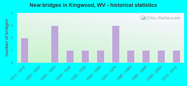
- New bridges - historical statistics
- 21910-1919
- 31930-1939
- 11940-1949
- 11950-1959
- 11960-1969
- 31970-1979
- 11980-1989
- 11990-1999
- 12000-2009
- 12010-2019


- Bridge Condition - Deck
- 80.0%Good
- 20.0%Poor

- Bridge Condition - Superstructure
- 20.0%Very good
- 10.0%Good
- 20.0%Satisfactory
- 40.0%Fair
- 10.0%Poor

- Bridge Condition - Substructure
- 11.1%Very good
- 22.2%Good
- 22.2%Satisfactory
- 44.4%Fair

- Bridge Condition - Channel
- 15.4%Very good
- 53.8%Good
- 15.4%Satisfactory
- 7.7%Fair
- 7.7%Poor

- Bridge Condition - Culverts
- 33.3%Very good
- 33.3%Fair
- 33.3%Serious
Find on map >> Show street view
Structure Number: 39A017, Location: 0.03 MI EAST WV RT 72 (Lat: 39.462511, Lng: -79.650411), Route carried "on" structure: State highway 700, Year Built: 1978, Status: Open, Structure Length: 28.95m (94.98ft), Average Daily Traffic: 9,700 (year 2019), Truck Traffic: 14%, Average Future Daily Traffic: 10,200 (year 2041), Design Load: HS 20, Features Intersected: Cheat River, 7/26, 72/10, Facility Carried by Structure: WV ROUTE 7
Minimum Vertical Clearance: 30+ m (98+ ft), Kilometerpoint: 24.784, Lanes on structure: 2, Lanes under structure: 2, Base Highway Network: Yes, Owner: State Highway Agency, Approaching Roadway Width: 7.9m (25.9ft), Material/Design: Steel continuous, Design/Construction: Stringer/Multi-beam, Number Of Spans In Main Unit: 3, Number Of Approach Spans: 3, Length of Maximum Span: 49.4m (162.1ft), Curb-To-Curb Width: 9.1m (29.9ft), Out-to-Out Width: 10.4m (34.1ft)
Condition: Deck: Good, Superstructure: Fair, Substructure: Fair, Channel: Good, Operating Rating: 68.9 metric tons, Method Used To Determine Operating Rating: Load Factor (LF), Inventory Rating: 41.7 metric tons, Method Used To Determine Inventory Rating: Load Factor (LF), Structural Evaluation: Somewhat better than minimum adequacy, Deck Geometry: Meets minimum limits, Underclear: High priority of corrective action, Waterway Adequacy: Superior to present desirable criteria, Approach Roadway Alignment: Better than present minimum criteria, Length Of Structure Improvement: 28.96m (95.01ft), Designated Inspection Frequency: Every 24 months, Underwater Inspection Frequency: Every 60 months, Inspection Date: May 2021, Underwater Inspection Date: July 2019, Deck Structure Type: Concrete Cast-file-Place, Wearing Surface/Protective System: Deck Protection: Epoxy Coated Reinforcing
Find on map >> Show street view
Structure Number: 39A026, Location: 0.18 MI NORTH CO RT 7/14 (Lat: 39.445119, Lng: -79.654039), Route carried "on" structure: County highway 713, Year Built: 1940, Status: Open, Structure Length: 0.75m (2.46ft), Average Daily Traffic: 200 (year 2019), Truck Traffic: 7%, Average Future Daily Traffic: 280 (year 2041), Features Intersected: BUFFALO RUN, Facility Carried by Structure: PRESTON CO RT 7/13
Minimum Vertical Clearance: 30+ m (98+ ft), Kilometerpoint: 3.750, Lanes on structure: 2, Owner: State Highway Agency, Approaching Roadway Width: 4.9m (16.1ft), Skew: 4 degrees, Material/Design: Concrete, Design/Construction: Slab, Number Of Spans In Main Unit: 1, Length of Maximum Span: 6.5m (21.3ft), Curb or Sidewalk Widths: Left: 0.1m (0.3ft), Right: 0.1m (0.3ft), Curb-To-Curb Width: 5.2m (17.1ft), Out-to-Out Width: 6.2m (20.3ft)
Condition: Superstructure: Satisfactory, Substructure: Satisfactory, Channel: Good, Operating Rating: 47.2 metric tons, Method Used To Determine Operating Rating: Field evaluation and documented engineering judgment, Inventory Rating: 21.8 metric tons, Method Used To Determine Inventory Rating: Field evaluation and documented engineering judgment, Structural Evaluation: Equal to present minimum criteria, Deck Geometry: High priority of replacement, Waterway Adequacy: Better than present minimum criteria, Approach Roadway Alignment: Meets minimum limits, Length Of Structure Improvement: 0.76m (2.49ft), Designated Inspection Frequency: Every 24 months, Inspection Date: April 2021, Bridge Improvement Cost: $243,000, Roadway Improvement Cost: $191,000, Total Project Cost: $517,000 ( Estimate for 2021), Deck Structure Type: Concrete Cast-file-Place, Wearing Surface/Protective System: Wearing Surface: Bituminous
Find on map >> Show street view
Structure Number: 39A064, Location: 0.02 MI EAST CO RT 26/72 (Lat: 39.459500, Lng: -79.701400), Route carried "on" structure: County highway 2664, Year Built: 1917, Status: Open, Structure Length: 0.91m (2.99ft), Average Daily Traffic: 300 (year 2019), Truck Traffic: 7%, Average Future Daily Traffic: 425 (year 2041), Features Intersected: MORGAN RUN, Facility Carried by Structure: PRESTON CR 26/64
Minimum Vertical Clearance: 30+ m (98+ ft), Kilometerpoint: 0.032, Lanes on structure: 2, Owner: State Highway Agency, Approaching Roadway Width: 4.9m (16.1ft), Material/Design: Concrete, Design/Construction: Arch - Deck, Number Of Spans In Main Unit: 1, Length of Maximum Span: 9.1m (29.9ft), Curb-To-Curb Width: 5.3m (17.4ft), Out-to-Out Width: 6.1m (20.0ft)
Condition: Superstructure: Fair, Channel: Good, Operating Rating: 31.7 metric tons, Method Used To Determine Operating Rating: Field evaluation and documented engineering judgment, Inventory Rating: 14.5 metric tons, Method Used To Determine Inventory Rating: Field evaluation and documented engineering judgment, Structural Evaluation: Meets minimum limits, Deck Geometry: High priority of replacement, Waterway Adequacy: Better than present minimum criteria, Approach Roadway Alignment: Equal to present minimum criteria, Length Of Structure Improvement: 1.62m (5.31ft), Designated Inspection Frequency: Every 24 months, Inspection Date: October 2021, Bridge Improvement Cost: $253,000, Roadway Improvement Cost: $152,000, Total Project Cost: $484,000 ( Estimate for 2022)
Find on map >> Show street view
Structure Number: 39A127, Location: 0.36 MI NORTH WV RT 26 (Lat: 39.486661, Lng: -79.660889), Route carried "on" structure: County highway 5200, Year Built: 1954, Status: Open, Structure Length: 1.39m (4.56ft), Average Daily Traffic: 100 (year 2018), Average Future Daily Traffic: 130 (year 2038), Design Load: HS 20, Features Intersected: GREENS RUN, Facility Carried by Structure: PRESTON CO RT 52
Minimum Vertical Clearance: 30+ m (98+ ft), Kilometerpoint: 0.579, Lanes on structure: 1, Owner: State Highway Agency, Approaching Roadway Width: 4.9m (16.1ft), Skew: 1 degrees, Material/Design: Steel, Design/Construction: Girder and Floorbeam System, Number Of Spans In Main Unit: 1, Length of Maximum Span: 12.6m (41.3ft), Curb-To-Curb Width: 4.1m (13.5ft), Out-to-Out Width: 4.1m (13.5ft)
Condition: Deck: Good, Superstructure: Fair, Substructure: Fair, Channel: Good, Operating Rating: 40.8 metric tons, Method Used To Determine Operating Rating: Load Factor (LF), Inventory Rating: 24.5 metric tons, Method Used To Determine Inventory Rating: Load Factor (LF), Structural Evaluation: Somewhat better than minimum adequacy, Deck Geometry: Somewhat better than minimum adequacy, Waterway Adequacy: Better than present minimum criteria, Approach Roadway Alignment: Meets minimum limits, Length Of Structure Improvement: 1.95m (6.40ft), Designated Inspection Frequency: Every 24 months, Critical Feature Inspection Frequency: Every 24 months, Inspection Date: August 2020, Critical Feature Inspection Date: August 2020, Bridge Improvement Cost: $287,000, Roadway Improvement Cost: $101,000, Total Project Cost: $411,000 ( Estimate for 2020), Deck Structure Type: Concrete Cast-file-Place
Find on map >> Show street view
Structure Number: 39A128, Location: 0.14 MI SOUTH CO RT 52/7 (Lat: 39.491081, Lng: -79.668931), Route carried "on" structure: County highway 5200, Year Built: 1960, Status: Open, Structure Length: 0.78m (2.56ft), Average Daily Traffic: 100 (year 2018), Average Future Daily Traffic: 130 (year 2038), Design Load: HS 20, Features Intersected: GREENS RUN, Facility Carried by Structure: PRESTON CO RT 52
Minimum Vertical Clearance: 30+ m (98+ ft), Kilometerpoint: 1.481, Lanes on structure: 2, Owner: State Highway Agency, Approaching Roadway Width: 5.5m (18.0ft), Material/Design: Steel, Design/Construction: Stringer/Multi-beam, Number Of Spans In Main Unit: 1, Length of Maximum Span: 6.7m (22.0ft), Curb-To-Curb Width: 6.0m (19.7ft), Out-to-Out Width: 6.2m (20.3ft)
Condition: Deck: Good, Superstructure: Very good, Substructure: Good, Channel: Good, Operating Rating: 81.6 metric tons, Method Used To Determine Operating Rating: Load Factor (LF), Inventory Rating: 49.0 metric tons, Method Used To Determine Inventory Rating: Load Factor (LF), Structural Evaluation: Better than present minimum criteria, Deck Geometry: Meets minimum limits, Waterway Adequacy: Equal to present minimum criteria, Approach Roadway Alignment: Equal to present desirable criteria, Designated Inspection Frequency: Every 24 months, Inspection Date: August 2020, Deck Structure Type: Concrete Cast-file-Place
Find on map >> Show street view
Structure Number: 39A13, Location: 0.05 MI SOUTH CO RT 52/8 (Lat: 39.496000, Lng: -79.675400), Route carried "on" structure: County highway 5200, Year Built: 1918, Status: Open, Structure Length: 0.94m (3.08ft), Average Daily Traffic: 300 (year 2019), Truck Traffic: 7%, Average Future Daily Traffic: 420 (year 2041), Features Intersected: GREENS RUN, Facility Carried by Structure: PRESTON CO RT 52
Minimum Vertical Clearance: 30+ m (98+ ft), Kilometerpoint: 2.285, Lanes on structure: 1, Owner: State Highway Agency, Approaching Roadway Width: 4.3m (14.1ft), Skew: 1 degrees, Material/Design: Concrete, Design/Construction: Arch - Deck, Number Of Spans In Main Unit: 1, Length of Maximum Span: 9.4m (30.8ft), Curb-To-Curb Width: 4.0m (13.1ft), Out-to-Out Width: 4.8m (15.7ft)
Condition: Superstructure: Satisfactory, Substructure: Satisfactory, Channel: Good, Operating Rating: 47.2 metric tons, Method Used To Determine Operating Rating: Field evaluation and documented engineering judgment, Inventory Rating: 21.8 metric tons, Method Used To Determine Inventory Rating: Field evaluation and documented engineering judgment, Structural Evaluation: Equal to present minimum criteria, Deck Geometry: High priority of replacement, Waterway Adequacy: Better than present minimum criteria, Approach Roadway Alignment: High priority of replacement, Length Of Structure Improvement: 1.65m (5.41ft), Designated Inspection Frequency: Every 24 months, Inspection Date: September 2021, Bridge Improvement Cost: $208,000, Roadway Improvement Cost: $163,000, Total Project Cost: $449,000 ( Estimate for 2021)
Find on map >> Show street view
Structure Number: 39A144, Location: 2.19 MI SOUTH ALT RT 72 (Lat: 39.416250, Lng: -79.688061), Route carried "on" structure: State highway 7200, Year Built: 1936, Status: Posted for load, Structure Length: 1.44m (4.72ft), Average Daily Traffic: 1,100 (year 2019), Truck Traffic: 11%, Average Future Daily Traffic: 1,160 (year 2041), Features Intersected: PRINGLE RUN, Facility Carried by Structure: WV ROUTE 72
Minimum Vertical Clearance: 30+ m (98+ ft), Kilometerpoint: 26.120, Lanes on structure: 2, Base Highway Network: Yes, Owner: State Highway Agency, Approaching Roadway Width: 7.6m (24.9ft), Material/Design: Concrete, Design/Construction: Tee Beam, Number Of Spans In Main Unit: 1, Length of Maximum Span: 13.6m (44.6ft), Curb-To-Curb Width: 7.9m (25.9ft), Out-to-Out Width: 8.8m (28.9ft)
Condition: Deck: Poor, Superstructure: Poor, Substructure: Fair, Channel: Poor, Operating Rating: 33.6 metric tons, Method Used To Determine Operating Rating: Field evaluation and documented engineering judgment, Inventory Rating: 14.5 metric tons, Method Used To Determine Inventory Rating: Field evaluation and documented engineering judgment, Structural Evaluation: Meets minimum limits, Deck Geometry: Meets minimum limits, Waterway Adequacy: Equal to present minimum criteria, Approach Roadway Alignment: Equal to present minimum criteria, Bridge Posting: Required (Relationship of Operating Rating to Maximum Legal Load: 0.1 - 9.9% below), Length Of Structure Improvement: 2.07m (6.79ft), Designated Inspection Frequency: Every 24 months, Other Special Inspection Frequency: Every 12 months, Inspection Date: July 2021, Other Special Inspection Date: July 2021, Bridge Improvement Cost: $342,000, Roadway Improvement Cost: $261,000, Total Project Cost: $714,000 ( Estimate for 2021), Deck Structure Type: Concrete Cast-file-Place, Wearing Surface/Protective System: Wearing Surface: Bituminous
Find on map >> Show street view
Structure Number: 39A146, Location: 0.11 MI NORTH ALT WV 72 (Lat: 39.447069, Lng: -79.678219), Route carried "on" structure: State highway 7200, Year Built: 1988, Status: Open, Structure Length: 1.05m (3.44ft), Average Daily Traffic: 1,100 (year 2019), Truck Traffic: 11%, Average Future Daily Traffic: 1,155 (year 2041), Design Load: HS 25 or greater, Features Intersected: MORGAN RUN, Facility Carried by Structure: WV ROUTE 72
Minimum Vertical Clearance: 30+ m (98+ ft), Kilometerpoint: 29.821, Lanes on structure: 2, Base Highway Network: Yes, Owner: State Highway Agency, Approaching Roadway Width: 7.9m (25.9ft), Skew: 1 degrees, Material/Design: Prestressed concrete, Design/Construction: Box Beam or Girders - Multiple, Number Of Spans In Main Unit: 1, Length of Maximum Span: 10.1m (33.1ft), Curb-To-Curb Width: 8.0m (26.2ft), Out-to-Out Width: 8.3m (27.2ft)
Condition: Superstructure: Fair, Substructure: Fair, Channel: Very good, Operating Rating: 46.3 metric tons, Method Used To Determine Operating Rating: Load Factor (LF), Inventory Rating: 28.1 metric tons, Method Used To Determine Inventory Rating: Load Factor (LF), Structural Evaluation: Somewhat better than minimum adequacy, Deck Geometry: Meets minimum limits, Waterway Adequacy: Equal to present minimum criteria, Approach Roadway Alignment: Equal to present desirable criteria, Length Of Structure Improvement: 1.01m (3.31ft), Designated Inspection Frequency: Every 24 months, Other Special Inspection Frequency: Every 12 months, Inspection Date: June 2020, Other Special Inspection Date: June 2021, Bridge Improvement Cost: $218,000, Roadway Improvement Cost: $54,000, Total Project Cost: $414,000 ( Estimate for 2020), Deck Structure Type: Other, Wearing Surface/Protective System: Wearing Surface: Bituminous, Deck Protection: Epoxy Coated Reinforcing
Find on map >> Show street view
Structure Number: 39A2, Location: 0.04 MI NORTH CO RT 52/6 (Lat: 39.509869, Lng: -79.692400), Route carried "on" structure: County highway 5200, Year Built: 1997, Status: Open, Structure Length: 1.32m (4.33ft), Average Daily Traffic: 300 (year 2018), Truck Traffic: 13%, Average Future Daily Traffic: 375 (year 2038), Design Load: HS 25 or greater, Features Intersected: GREENS RUN, Facility Carried by Structure: COUNTY ROUTE 52
Minimum Vertical Clearance: 30+ m (98+ ft), Kilometerpoint: 4.571, Lanes on structure: 2, Owner: State Highway Agency, Approaching Roadway Width: 6.1m (20.0ft), Skew: 3 degrees, Material/Design: Prestressed concrete, Design/Construction: Box Beam or Girders - Multiple, Number Of Spans In Main Unit: 1, Length of Maximum Span: 11.6m (38.1ft), Curb-To-Curb Width: 6.3m (20.7ft), Out-to-Out Width: 6.5m (21.3ft)
Condition: Superstructure: Good, Substructure: Good, Channel: Satisfactory, Operating Rating: 72.6 metric tons, Method Used To Determine Operating Rating: Load Factor (LF), Inventory Rating: 43.5 metric tons, Method Used To Determine Inventory Rating: Load Factor (LF), Structural Evaluation: Better than present minimum criteria, Deck Geometry: Meets minimum limits, Waterway Adequacy: Better than present minimum criteria, Approach Roadway Alignment: Somewhat better than minimum adequacy, Designated Inspection Frequency: Every 48 months, Inspection Date: August 2019, Deck Structure Type: Other, Wearing Surface/Protective System: Wearing Surface: Bituminous, Deck Protection: Epoxy Coated Reinforcing
Find on map >> Show street view
Structure Number: 39A219, Location: 0.40 MI SOUTH CO RT 7/12 (Lat: 39.458211, Lng: -79.655281), Route carried "on" structure: County highway 726, Year Built: 2002, Status: Open, Structure Length: 2.90m (9.51ft), Average Daily Traffic: 950 (year 2016), Truck Traffic: 13%, Average Future Daily Traffic: 1,275 (year 2036), Design Load: HL 93, Features Intersected: BUFFALO RUN, Facility Carried by Structure: PRESTON CO RT 7/26
Minimum Vertical Clearance: 30+ m (98+ ft), Kilometerpoint: 0.644, Lanes on structure: 2, Owner: State Highway Agency, Approaching Roadway Width: 7.9m (25.9ft), Skew: 1 degrees, Material/Design: Prestressed concrete, Design/Construction: Stringer/Multi-beam, Number Of Spans In Main Unit: 1, Length of Maximum Span: 28.0m (91.9ft), Curb-To-Curb Width: 7.8m (25.6ft), Out-to-Out Width: 8.7m (28.5ft)
Condition: Deck: Good, Superstructure: Very good, Substructure: Very good, Channel: Good, Operating Rating: 65.3 metric tons, Method Used To Determine Operating Rating: Load and Resistance Factor (LRFR), Inventory Rating: 49.9 metric tons, Method Used To Determine Inventory Rating: Load and Resistance Factor (LRFR), Structural Evaluation: Equal to present desirable criteria, Deck Geometry: Meets minimum limits, Waterway Adequacy: Better than present minimum criteria, Approach Roadway Alignment: Equal to present desirable criteria, Designated Inspection Frequency: Every 48 months, Inspection Date: May 2018, Deck Structure Type: Concrete Cast-file-Place, Wearing Surface/Protective System: Deck Protection: Epoxy Coated Reinforcing
Find on map >> Show street view
Structure Number: 39A245, Location: 0.02 mi N of Pre Co 26/72 (Lat: 39.458939, Lng: -79.698061), Route carried "on" structure: State highway 26, Year Built: 1936, Status: Posted for load, Structure Length: 0.82m (2.69ft), Average Daily Traffic: 3,800 (year 2019), Truck Traffic: 11%, Average Future Daily Traffic: 3,990 (year 2041), Design Load: H 20, Features Intersected: Morgan Run
Minimum Vertical Clearance: 30+ m (98+ ft), Kilometerpoint: 23.496, Lanes on structure: 2, Base Highway Network: Yes, Owner: State Highway Agency, Approaching Roadway Width: 7.0m (23.0ft), Skew: 3 degrees, Material/Design: Concrete, Design/Construction: Culvert, Number Of Spans In Main Unit: 1, Length of Maximum Span: 8.2m (26.9ft)
Condition: Channel: Satisfactory, Culverts: Serious, Operating Rating: 38.1 metric tons, Method Used To Determine Operating Rating: Field evaluation and documented engineering judgment, Inventory Rating: 17.2 metric tons, Method Used To Determine Inventory Rating: Field evaluation and documented engineering judgment, Structural Evaluation: High priority of corrective action, Waterway Adequacy: Better than present minimum criteria, Approach Roadway Alignment: Better than present minimum criteria, Bridge Posting: Required (Relationship of Operating Rating to Maximum Legal Load: 0.1 - 9.9% below), Length Of Structure Improvement: 1.23m (4.04ft), Designated Inspection Frequency: Every 24 months, Other Special Inspection Frequency: Every 12 months, Inspection Date: August 2021, Other Special Inspection Date: August 2021, Bridge Improvement Cost: $407,000, Roadway Improvement Cost: $114,000, Total Project Cost: $573,000 ( Estimate for 2021)
Find on map >> Show street view
Structure Number: 39A247, Location: 0.30 mi. North of WV 72 (Lat: 39.449981, Lng: -79.681269), Route carried "on" structure: Alternate State highway 72, Year Built: 2013, Status: Open, Structure Length: 1.01m (3.31ft), Average Daily Traffic: 550 (year 2018), Truck Traffic: 14%, Average Future Daily Traffic: 725 (year 2038), Design Load: HL 93, Features Intersected: Morgans Run
Minimum Vertical Clearance: 30+ m (98+ ft), Kilometerpoint: 0.483, Lanes on structure: 2, Owner: State Highway Agency, Approaching Roadway Width: 6.4m (21.0ft), Material/Design: Concrete, Design/Construction: Culvert, Number Of Spans In Main Unit: 1, Length of Maximum Span: 10.1m (33.1ft), Curb-To-Curb Width: 9.8m (32.2ft), Out-to-Out Width: 10.9m (35.8ft)
Condition: Channel: Very good, Culverts: Very good, Operating Rating: 88.9 metric tons, Method Used To Determine Operating Rating: Field evaluation and documented engineering judgment, Inventory Rating: 40.8 metric tons, Method Used To Determine Inventory Rating: Field evaluation and documented engineering judgment, Structural Evaluation: Equal to present desirable criteria, Deck Geometry: Equal to present minimum criteria, Waterway Adequacy: Equal to present desirable criteria, Approach Roadway Alignment: Meets minimum limits, Designated Inspection Frequency: Every 48 months, Inspection Date: August 2019
Find on map >> Show street view
Structure Number: 39A901, Location: 0.07 MI WEST CO RT 43 (Lat: 39.464000, Lng: -79.691361), Route carried "on" structure: City street 2664, Year Built: 1930, Status: Open, Structure Length: 0.67m (2.20ft), Average Daily Traffic: 300 (year 2019), Truck Traffic: 13%, Average Future Daily Traffic: 400 (year 2039), Features Intersected: INDIAN CREEK, Facility Carried by Structure: Pres Co 26/64
Minimum Vertical Clearance: 30+ m (98+ ft), Kilometerpoint: 1.593, Lanes on structure: 2, Owner: State Highway Agency, Approaching Roadway Width: 5.5m (18.0ft), Material/Design: Concrete, Design/Construction: Culvert, Number Of Spans In Main Unit: 1, Length of Maximum Span: 6.7m (22.0ft)
Condition: Channel: Fair, Culverts: Fair, Operating Rating: 47.2 metric tons, Method Used To Determine Operating Rating: Field evaluation and documented engineering judgment, Inventory Rating: 21.8 metric tons, Method Used To Determine Inventory Rating: Field evaluation and documented engineering judgment, Structural Evaluation: Somewhat better than minimum adequacy, Waterway Adequacy: Superior to present desirable criteria, Approach Roadway Alignment: Better than present minimum criteria, Length Of Structure Improvement: 1.28m (4.20ft), Designated Inspection Frequency: Every 24 months, Inspection Date: Febuary 2021, Bridge Improvement Cost: $178,000, Roadway Improvement Cost: $131,000, Total Project Cost: $364,000 ( Estimate for 2021)
Find on map >> Show street view
Structure Number: 39A017, Location: 0.03 MI EAST WV RT 72 (Lat: 39.462511, Lng: -79.650411), Route carried "under" structure: County highway 726, Year Built: 1978, Structure Length: 0. m, Average Daily Traffic: 1,025 (year 0017), Truck Traffic: 13%, Features Intersected: Cheat River, 7/26, 72/10, Facility Carried by Structure: WV ROUTE 7
Minimum Vertical Clearance: 9.55m (31.33ft), Kilometerpoint: 0.016, Lanes on structure: 2, Lanes under structure: 2, Length of Maximum Span: 49.4m (162.1ft)
Find on map >> Show street view
Structure Number: 39A017, Location: 0.03 MI EAST WV RT 72 (Lat: 39.462511, Lng: -79.650411), Route carried "under" structure: County highway 7210, Year Built: 1978, Structure Length: 0. m, Average Daily Traffic: 10 (year 0017), Features Intersected: Cheat River, 7/26, 72/10, Facility Carried by Structure: WV ROUTE 7
Minimum Vertical Clearance: 5.16m (16.93ft), Kilometerpoint: 0.032, Lanes on structure: 2, Lanes under structure: 2, Length of Maximum Span: 49.4m (162.1ft)