Bridge Statistics for Kingsville, Texas (TX)
Condition, Traffic, Stress, Structural Evaluation, Project Costs
- National Bridge Inventory (NBI) Statistics
- 51Number of bridges
- 814ft / 248mTotal length
- $455,000Total costs
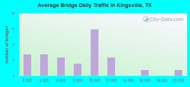
- 354,888Total average daily traffic
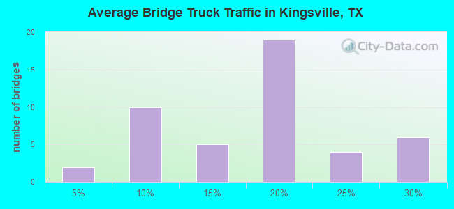
- 59,484Total average daily truck traffic
- National Bridge Inventory (NBI) Registered Bridges for Kingsville
- No street view available for this location
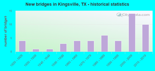
- New bridges - historical statistics
- 41920-1929
- 11930-1939
- 11940-1949
- 31950-1959
- 41960-1969
- 41970-1979
- 61980-1989
- 41990-1999
- 142000-2009
- 102010-2019
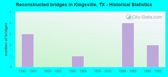
- Reconstructed bridges - Historical Statistics
- 31940-1949
- 01950-1959
- 11960-1969
- 01970-1979
- 41980-1989
- 21990-1999
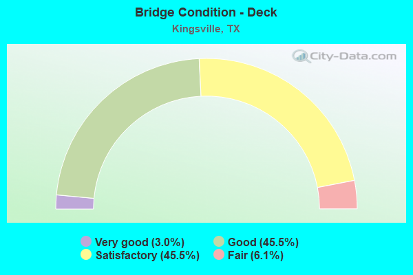
- Bridge Condition - Deck
- 3.0%Very good
- 45.5%Good
- 45.5%Satisfactory
- 6.1%Fair
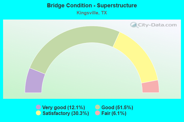
- Bridge Condition - Superstructure
- 12.1%Very good
- 51.5%Good
- 30.3%Satisfactory
- 6.1%Fair
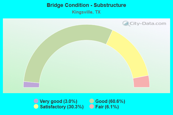
- Bridge Condition - Substructure
- 3.0%Very good
- 60.6%Good
- 30.3%Satisfactory
- 6.1%Fair
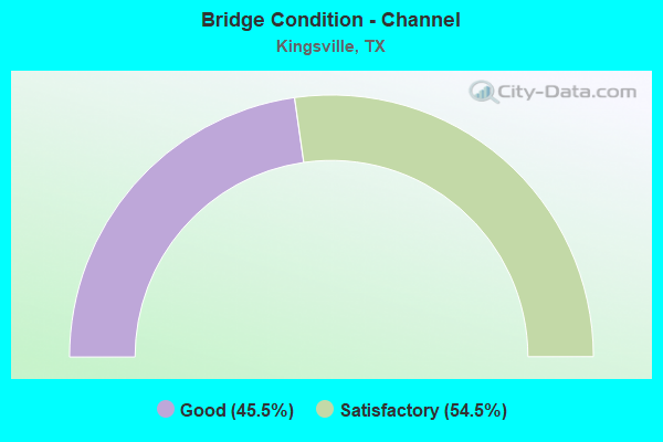
- Bridge Condition - Channel
- 45.5%Good
- 54.5%Satisfactory
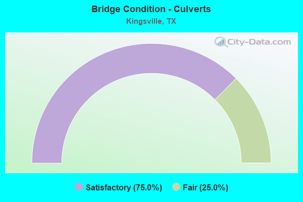
- Bridge Condition - Culverts
- 75.0%Satisfactory
- 25.0%Fair
Find on map >> Show street view
Structure Number: 161370010204017, Location: 0.9 MI S OF FM 1118 (Lat: 27.408219, Lng: -97.847486), Route carried "on" structure: US 77, Year Built: 1922, Year Reconstructed: 1953, Status: Open, Structure Length: 3.66m (12.01ft), Average Daily Traffic: 9,304 (year 2019), Truck Traffic: 26%, Average Future Daily Traffic: 13,750 (year 2033), Design Load: H 20, Features Intersected: JABONCILLOS CREEK
Minimum Vertical Clearance: 30+ m (98+ ft), Kilometerpoint: 19.127, Lanes on structure: 2, Owner: State Highway Agency, Approaching Roadway Width: 11.6m (38.1ft), Material/Design: Concrete, Design/Construction: Slab, Number Of Spans In Main Unit: 6, Length of Maximum Span: 6.1m (20.0ft), Curb-To-Curb Width: 12.2m (40.0ft), Out-to-Out Width: 13.0m (42.7ft)
Condition: Deck: Satisfactory, Superstructure: Satisfactory, Substructure: Satisfactory, Channel: Satisfactory, Operating Rating: 44.4 metric tons, Method Used To Determine Operating Rating: Load Factor (LF), Inventory Rating: 20.0 metric tons, Method Used To Determine Inventory Rating: Load Factor (LF), Structural Evaluation: Somewhat better than minimum adequacy, Deck Geometry: Better than present minimum criteria, Waterway Adequacy: Equal to present minimum criteria, Approach Roadway Alignment: Equal to present desirable criteria, Length Of Structure Improvement: 3.66m (12.01ft), Designated Inspection Frequency: Every 24 months, Inspection Date: June 2020, Bridge Improvement Cost: $96,000, Roadway Improvement Cost: $24,000, Total Project Cost: $120,000, Deck Structure Type: Concrete Cast-file-Place, Wearing Surface/Protective System: Wearing Surface: Bituminous
Find on map >> Show street view
Structure Number: 161370010204056, Location: 0.7 MI N OF FM 1898 (Lat: 27.538167, Lng: -97.832453), Route carried "on" structure: US 77, Year Built: 1965, Status: Open, Structure Length: 7.32m (24.02ft), Average Daily Traffic: 10,970 (year 2013), Truck Traffic: 17%, Average Future Daily Traffic: 15,360 (year 2033), Design Load: HS 20, Features Intersected: SAN FERNANDO CREEK
Minimum Vertical Clearance: 30+ m (98+ ft), Kilometerpoint: 3.883, Lanes on structure: 2, Owner: State Highway Agency, Approaching Roadway Width: 12.2m (40.0ft), Material/Design: Concrete, Design/Construction: Stringer/Multi-beam, Number Of Spans In Main Unit: 6, Length of Maximum Span: 12.2m (40.0ft), Curb-To-Curb Width: 12.2m (40.0ft), Out-to-Out Width: 12.9m (42.3ft)
Condition: Deck: Satisfactory, Superstructure: Satisfactory, Substructure: Fair, Channel: Satisfactory, Operating Rating: 68.0 metric tons, Method Used To Determine Operating Rating: Load Factor (LF), Inventory Rating: 40.8 metric tons, Method Used To Determine Inventory Rating: Load Factor (LF), Structural Evaluation: Somewhat better than minimum adequacy, Deck Geometry: Better than present minimum criteria, Waterway Adequacy: Equal to present minimum criteria, Approach Roadway Alignment: Equal to present desirable criteria, Length Of Structure Improvement: 7.32m (24.02ft), Designated Inspection Frequency: Every 24 months, Inspection Date: June 2020, Bridge Improvement Cost: $192,000, Roadway Improvement Cost: $48,000, Total Project Cost: $240,000, Deck Structure Type: Concrete Cast-file-Place, Wearing Surface/Protective System: Wearing Surface: Bituminous
Find on map >> Show street view
Structure Number: 161370010204057, Location: 0.3 MI N OF SH 141 (Lat: 27.520533, Lng: -97.841378), Route carried "on" structure: ServiceUS 77, Year Built: 1965, Status: Open, Structure Length: 4.88m (16.01ft), Average Daily Traffic: 100 (year 2013), Truck Traffic: 10%, Average Future Daily Traffic: 140 (year 2033), Features Intersected: TRANQUITAS CREEK
Minimum Vertical Clearance: 30+ m (98+ ft), Kilometerpoint: 6.133, Lanes on structure: 2, Owner: State Highway Agency, Approaching Roadway Width: 12.2m (40.0ft), Material/Design: Concrete, Design/Construction: Stringer/Multi-beam, Number Of Spans In Main Unit: 4, Length of Maximum Span: 12.2m (40.0ft), Curb-To-Curb Width: 12.3m (40.4ft), Out-to-Out Width: 12.9m (42.3ft)
Condition: Deck: Good, Superstructure: Good, Substructure: Good, Channel: Satisfactory, Operating Rating: 52.6 metric tons, Method Used To Determine Operating Rating: Load Factor (LF), Inventory Rating: 31.7 metric tons, Method Used To Determine Inventory Rating: Load Factor (LF), Structural Evaluation: Better than present minimum criteria, Deck Geometry: Better than present minimum criteria, Waterway Adequacy: Equal to present minimum criteria, Approach Roadway Alignment: Equal to present desirable criteria, Designated Inspection Frequency: Every 24 months, Inspection Date: June 2020, Deck Structure Type: Concrete Cast-file-Place, Wearing Surface/Protective System: Wearing Surface: Bituminous
Find on map >> Show street view
Structure Number: 161370010204058, Location: 0.1 MI S OF FM 1717 (Lat: 27.476950, Lng: -97.854867), Route carried "on" structure: US 77, Year Built: 1965, Status: Open, Structure Length: 7.34m (24.08ft), Average Daily Traffic: 9,500 (year 2020), Truck Traffic: 18%, Average Future Daily Traffic: 12,280 (year 2033), Design Load: H 20, Features Intersected: SANTA GERTRUDIS CREEK
Minimum Vertical Clearance: 30+ m (98+ ft), Kilometerpoint: 11.327, Lanes on structure: 2, Owner: State Highway Agency, Approaching Roadway Width: 11.6m (38.1ft), Material/Design: Concrete, Design/Construction: Stringer/Multi-beam, Number Of Spans In Main Unit: 6, Length of Maximum Span: 12.2m (40.0ft), Curb-To-Curb Width: 12.2m (40.0ft), Out-to-Out Width: 12.9m (42.3ft)
Condition: Deck: Satisfactory, Superstructure: Satisfactory, Substructure: Satisfactory, Channel: Good, Operating Rating: 32.7 metric tons, Method Used To Determine Operating Rating: Field evaluation and documented engineering judgment, Inventory Rating: 24.5 metric tons, Method Used To Determine Inventory Rating: Field evaluation and documented engineering judgment, Structural Evaluation: Equal to present minimum criteria, Deck Geometry: Better than present minimum criteria, Waterway Adequacy: Equal to present minimum criteria, Approach Roadway Alignment: Equal to present desirable criteria, Designated Inspection Frequency: Every 24 months, Inspection Date: June 2020, Deck Structure Type: Concrete Cast-file-Place
Find on map >> Show street view
Structure Number: 161370010204059, Location: 0.7 MI S OF FM 1717 (Lat: 27.466081, Lng: -97.855253), Route carried "on" structure: US 77, Year Built: 1965, Status: Open, Structure Length: 6.10m (20.01ft), Average Daily Traffic: 9,500 (year 2020), Truck Traffic: 18%, Average Future Daily Traffic: 12,280 (year 2033), Design Load: HS 20, Features Intersected: ESCONDIDO CREEK
Minimum Vertical Clearance: 30+ m (98+ ft), Kilometerpoint: 12.527, Lanes on structure: 2, Owner: State Highway Agency, Approaching Roadway Width: 11.6m (38.1ft), Material/Design: Concrete, Design/Construction: Stringer/Multi-beam, Number Of Spans In Main Unit: 5, Length of Maximum Span: 12.2m (40.0ft), Curb-To-Curb Width: 12.2m (40.0ft), Out-to-Out Width: 12.9m (42.3ft)
Condition: Deck: Satisfactory, Superstructure: Satisfactory, Substructure: Satisfactory, Channel: Good, Operating Rating: 32.7 metric tons, Method Used To Determine Operating Rating: Field evaluation and documented engineering judgment, Inventory Rating: 24.5 metric tons, Method Used To Determine Inventory Rating: Field evaluation and documented engineering judgment, Structural Evaluation: Equal to present minimum criteria, Deck Geometry: Better than present minimum criteria, Waterway Adequacy: Equal to present minimum criteria, Approach Roadway Alignment: Equal to present desirable criteria, Designated Inspection Frequency: Every 24 months, Inspection Date: June 2020, Deck Structure Type: Concrete Cast-file-Place
Find on map >> Show street view
Structure Number: 161370010204065, Location: 0.7 MI N OF FM 1898 (Lat: 27.537511, Lng: -97.832769), Route carried "on" structure: US 77, Year Built: 1970, Status: Open, Structure Length: 7.32m (24.02ft), Average Daily Traffic: 10,970 (year 2013), Truck Traffic: 17%, Average Future Daily Traffic: 15,360 (year 2033), Design Load: HS 20, Features Intersected: SAN FERNANDO CREEK
Minimum Vertical Clearance: 30+ m (98+ ft), Kilometerpoint: 3.880, Lanes on structure: 2, Owner: State Highway Agency, Approaching Roadway Width: 12.2m (40.0ft), Material/Design: Concrete, Design/Construction: Stringer/Multi-beam, Number Of Spans In Main Unit: 6, Length of Maximum Span: 12.2m (40.0ft), Curb-To-Curb Width: 12.8m (42.0ft), Out-to-Out Width: 13.4m (44.0ft)
Condition: Deck: Satisfactory, Superstructure: Satisfactory, Substructure: Good, Channel: Satisfactory, Operating Rating: 32.7 metric tons, Method Used To Determine Operating Rating: Field evaluation and documented engineering judgment, Inventory Rating: 24.5 metric tons, Method Used To Determine Inventory Rating: Field evaluation and documented engineering judgment, Structural Evaluation: Equal to present minimum criteria, Deck Geometry: Equal to present desirable criteria, Waterway Adequacy: Equal to present minimum criteria, Approach Roadway Alignment: Equal to present desirable criteria, Designated Inspection Frequency: Every 24 months, Inspection Date: June 2020, Deck Structure Type: Concrete Cast-file-Place
Find on map >> Show street view
Structure Number: 161370010204066, Location: 0.3 MI N OF SH 141 (Lat: 27.520519, Lng: -97.840569), Route carried "on" structure: ServiceUS 77, Year Built: 1970, Status: Open, Structure Length: 4.88m (16.01ft), Average Daily Traffic: 2,934 (year 2020), Truck Traffic: 18%, Average Future Daily Traffic: 1,480 (year 2033), Design Load: HS 20, Features Intersected: TRANQUITAS CREEK
Minimum Vertical Clearance: 30+ m (98+ ft), Kilometerpoint: 6.133, Lanes on structure: 2, Owner: State Highway Agency, Approaching Roadway Width: 12.8m (42.0ft), Material/Design: Concrete, Design/Construction: Stringer/Multi-beam, Number Of Spans In Main Unit: 4, Length of Maximum Span: 12.2m (40.0ft), Curb-To-Curb Width: 12.8m (42.0ft), Out-to-Out Width: 13.5m (44.3ft)
Condition: Deck: Good, Superstructure: Good, Substructure: Good, Channel: Satisfactory, Operating Rating: 32.7 metric tons, Method Used To Determine Operating Rating: Field evaluation and documented engineering judgment, Inventory Rating: 24.5 metric tons, Method Used To Determine Inventory Rating: Field evaluation and documented engineering judgment, Structural Evaluation: Equal to present minimum criteria, Deck Geometry: Equal to present desirable criteria, Waterway Adequacy: Equal to present minimum criteria, Approach Roadway Alignment: Equal to present desirable criteria, Designated Inspection Frequency: Every 24 months, Inspection Date: June 2020, Deck Structure Type: Concrete Cast-file-Place
Find on map >> Show street view
Structure Number: 161370010204067, Location: 0.1 MI S OF FM 1717 (Lat: 27.476089, Lng: -97.854619), Route carried "on" structure: US 77, Year Built: 1970, Status: Open, Structure Length: 8.05m (26.41ft), Average Daily Traffic: 8,844 (year 2020), Truck Traffic: 18%, Average Future Daily Traffic: 12,280 (year 2033), Design Load: HS 20, Features Intersected: SANTA GERTRUDIS CREEK
Minimum Vertical Clearance: 30+ m (98+ ft), Kilometerpoint: 11.331, Lanes on structure: 2, Owner: State Highway Agency, Approaching Roadway Width: 12.2m (40.0ft), Skew: 4 degrees, Material/Design: Concrete, Design/Construction: Stringer/Multi-beam, Number Of Spans In Main Unit: 6, Length of Maximum Span: 13.4m (44.0ft), Curb-To-Curb Width: 12.7m (41.7ft), Out-to-Out Width: 13.5m (44.3ft)
Condition: Deck: Fair, Superstructure: Fair, Substructure: Fair, Channel: Good, Operating Rating: 32.7 metric tons, Method Used To Determine Operating Rating: Field evaluation and documented engineering judgment, Inventory Rating: 24.5 metric tons, Method Used To Determine Inventory Rating: Field evaluation and documented engineering judgment, Structural Evaluation: Somewhat better than minimum adequacy, Deck Geometry: Better than present minimum criteria, Waterway Adequacy: Equal to present minimum criteria, Approach Roadway Alignment: Equal to present desirable criteria, Designated Inspection Frequency: Every 24 months, Inspection Date: June 2020, Deck Structure Type: Concrete Cast-file-Place
Find on map >> Show street view
Structure Number: 161370010204068, Location: 0.7 MI S OF FM 1717 (Lat: 27.465539, Lng: -97.854811), Route carried "on" structure: US 77, Year Built: 1970, Status: Open, Structure Length: 6.10m (20.01ft), Average Daily Traffic: 8,844 (year 2020), Truck Traffic: 18%, Average Future Daily Traffic: 12,280 (year 2033), Design Load: HS 20, Features Intersected: ESCONDIDO CREEK
Minimum Vertical Clearance: 30+ m (98+ ft), Kilometerpoint: 12.527, Lanes on structure: 2, Owner: State Highway Agency, Approaching Roadway Width: 11.6m (38.1ft), Material/Design: Concrete, Design/Construction: Stringer/Multi-beam, Number Of Spans In Main Unit: 5, Length of Maximum Span: 12.2m (40.0ft), Curb-To-Curb Width: 12.8m (42.0ft), Out-to-Out Width: 13.5m (44.3ft)
Condition: Deck: Good, Superstructure: Good, Substructure: Good, Channel: Good, Operating Rating: 32.7 metric tons, Method Used To Determine Operating Rating: Field evaluation and documented engineering judgment, Inventory Rating: 24.5 metric tons, Method Used To Determine Inventory Rating: Field evaluation and documented engineering judgment, Structural Evaluation: Equal to present minimum criteria, Deck Geometry: Equal to present desirable criteria, Waterway Adequacy: Equal to present minimum criteria, Approach Roadway Alignment: Equal to present desirable criteria, Designated Inspection Frequency: Every 24 months, Inspection Date: June 2020, Deck Structure Type: Concrete Cast-file-Place
Find on map >> Show street view
Structure Number: 16137001020408, Location: 1.70 MI S OF SH 141 (Lat: 27.491692, Lng: -97.847189), Route carried "on" structure: ServiceUS 77, Year Built: 1981, Year Reconstructed: 2004, Status: Open, Structure Length: 0.76m (2.49ft), Average Daily Traffic: 14,400 (year 2012), Truck Traffic: 21%, Average Future Daily Traffic: 24,560 (year 2032), Design Load: HS 20, Features Intersected: DRAIN
Minimum Vertical Clearance: 30+ m (98+ ft), Kilometerpoint: 9.522, Lanes on structure: 2, Owner: State Highway Agency, Approaching Roadway Width: 13.4m (44.0ft), Skew: 3 degrees, Material/Design: Concrete, Design/Construction: Culvert, Number Of Spans In Main Unit: 2, Length of Maximum Span: 3.0m (9.8ft)
Condition: Channel: Good, Culverts: Satisfactory, Operating Rating: 39.9 metric tons, Method Used To Determine Operating Rating: Load Factor (LF), Inventory Rating: 23.6 metric tons, Method Used To Determine Inventory Rating: Load Factor (LF), Structural Evaluation: Somewhat better than minimum adequacy, Waterway Adequacy: Better than present minimum criteria, Approach Roadway Alignment: Equal to present desirable criteria, Designated Inspection Frequency: Every 48 months, Inspection Date: June 2020
Find on map >> Show street view
Structure Number: 161370010204081, Location: 1.70 MI S OF SH 141 (Lat: 27.491725, Lng: -97.846008), Route carried "on" structure: ServiceUS 77, Year Built: 1981, Year Reconstructed: 2004, Status: Open, Structure Length: 0.76m (2.49ft), Average Daily Traffic: 14,400 (year 2012), Truck Traffic: 21%, Average Future Daily Traffic: 24,560 (year 2032), Design Load: HS 20, Features Intersected: DRAIN
Minimum Vertical Clearance: 30+ m (98+ ft), Kilometerpoint: 9.473, Lanes on structure: 2, Owner: State Highway Agency, Approaching Roadway Width: 12.2m (40.0ft), Skew: 3 degrees, Material/Design: Concrete, Design/Construction: Culvert, Number Of Spans In Main Unit: 2, Length of Maximum Span: 3.0m (9.8ft)
Condition: Channel: Satisfactory, Culverts: Satisfactory, Operating Rating: 39.9 metric tons, Method Used To Determine Operating Rating: Load Factor (LF), Inventory Rating: 23.6 metric tons, Method Used To Determine Inventory Rating: Load Factor (LF), Structural Evaluation: Somewhat better than minimum adequacy, Waterway Adequacy: Better than present minimum criteria, Approach Roadway Alignment: Equal to present desirable criteria, Designated Inspection Frequency: Every 48 months, Inspection Date: June 2020
Find on map >> Show street view
Structure Number: 161370010204093, Location: 1.2 MI S OF SH 141 (Lat: 27.499294, Lng: -97.842308), Route carried "on" structure: US 77, Year Built: 1988, Status: Open, Structure Length: 12.19m (39.99ft), Average Daily Traffic: 7,330 (year 2020), Truck Traffic: 16%, Average Future Daily Traffic: 14,280 (year 2033), Design Load: HS 20, Features Intersected: FM 425
Minimum Vertical Clearance: 30+ m (98+ ft), Kilometerpoint: 8.555, Lanes on structure: 2, Lanes under structure: 6, Owner: State Highway Agency, Approaching Roadway Width: 11.6m (38.1ft), Material/Design: Prestressed concrete, Design/Construction: Stringer/Multi-beam, Number Of Spans In Main Unit: 4, Length of Maximum Span: 30.5m (100.1ft), Curb-To-Curb Width: 11.3m (37.1ft), Out-to-Out Width: 12.2m (40.0ft)
Condition: Deck: Satisfactory, Superstructure: Good, Substructure: Good, Operating Rating: 54.4 metric tons, Method Used To Determine Operating Rating: Assigned rating based on Load Factor Design (LFD) reported in metric tons, Inventory Rating: 32.7 metric tons, Method Used To Determine Inventory Rating: Assigned rating based on Load Factor Design (LFD) reported in metric tons, Structural Evaluation: Better than present minimum criteria, Deck Geometry: Somewhat better than minimum adequacy, Underclear: Equal to present minimum criteria, Approach Roadway Alignment: Equal to present desirable criteria, Designated Inspection Frequency: Every 24 months, Inspection Date: June 2020, Deck Structure Type: Concrete Cast-file-Place
Find on map >> Show street view
Structure Number: 161370010204094, Location: 1.2 MI S OF SH 141 (Lat: 27.498181, Lng: -97.842619), Route carried "on" structure: US 77, Year Built: 1988, Status: Open, Structure Length: 12.19m (39.99ft), Average Daily Traffic: 9,940 (year 2019), Truck Traffic: 16%, Average Future Daily Traffic: 14,280 (year 2033), Design Load: HS 20, Features Intersected: FM 425
Minimum Vertical Clearance: 30+ m (98+ ft), Kilometerpoint: 8.555, Lanes on structure: 2, Lanes under structure: 6, Owner: State Highway Agency, Approaching Roadway Width: 11.6m (38.1ft), Material/Design: Prestressed concrete, Design/Construction: Stringer/Multi-beam, Number Of Spans In Main Unit: 4, Length of Maximum Span: 30.5m (100.1ft), Curb-To-Curb Width: 11.3m (37.1ft), Out-to-Out Width: 12.2m (40.0ft)
Condition: Deck: Satisfactory, Superstructure: Good, Substructure: Good, Operating Rating: 54.4 metric tons, Method Used To Determine Operating Rating: Assigned rating based on Load Factor Design (LFD) reported in metric tons, Inventory Rating: 32.7 metric tons, Method Used To Determine Inventory Rating: Assigned rating based on Load Factor Design (LFD) reported in metric tons, Structural Evaluation: Better than present minimum criteria, Deck Geometry: Somewhat better than minimum adequacy, Underclear: Equal to present minimum criteria, Approach Roadway Alignment: Equal to present desirable criteria, Designated Inspection Frequency: Every 24 months, Inspection Date: June 2020, Deck Structure Type: Concrete Cast-file-Place
Find on map >> Show street view
Structure Number: 161370010204112, Location: 1.2 MI N OF FM 425 (Lat: 27.514478, Lng: -97.840556), Route carried "on" structure: US 77, Year Built: 1995, Status: Open, Structure Length: 20.42m (66.99ft), Average Daily Traffic: 9,057 (year 2020), Truck Traffic: 16%, Average Future Daily Traffic: 14,280 (year 2033), Design Load: HS 20, Features Intersected: SH 141 (E KING AVE)
Minimum Vertical Clearance: 30+ m (98+ ft), Kilometerpoint: 6.637, Lanes on structure: 2, Lanes under structure: 8, Owner: State Highway Agency, Approaching Roadway Width: 11.6m (38.1ft), Material/Design: Prestressed concrete, Design/Construction: Stringer/Multi-beam, Number Of Spans In Main Unit: 7, Length of Maximum Span: 30.5m (100.1ft), Curb-To-Curb Width: 11.3m (37.1ft), Out-to-Out Width: 12.2m (40.0ft)
Condition: Deck: Satisfactory, Superstructure: Good, Substructure: Good, Operating Rating: 54.4 metric tons, Method Used To Determine Operating Rating: Assigned rating based on Load Factor Design (LFD) reported in metric tons, Inventory Rating: 32.7 metric tons, Method Used To Determine Inventory Rating: Assigned rating based on Load Factor Design (LFD) reported in metric tons, Structural Evaluation: Better than present minimum criteria, Deck Geometry: Somewhat better than minimum adequacy, Underclear: High priority of corrective action, Approach Roadway Alignment: Equal to present desirable criteria, Designated Inspection Frequency: Every 24 months, Inspection Date: June 2020, Deck Structure Type: Concrete Cast-file-Place
Find on map >> Show street view
Structure Number: 161370010204113, Location: 1.2 MI N OF FM 425 (Lat: 27.514472, Lng: -97.840794), Route carried "on" structure: US 77, Year Built: 1995, Status: Open, Structure Length: 20.42m (66.99ft), Average Daily Traffic: 9,784 (year 2020), Truck Traffic: 16%, Average Future Daily Traffic: 14,280 (year 2033), Design Load: HS 20, Features Intersected: SH 141 (E KING AVE)
Minimum Vertical Clearance: 30+ m (98+ ft), Kilometerpoint: 6.637, Lanes on structure: 2, Lanes under structure: 8, Owner: State Highway Agency, Approaching Roadway Width: 11.6m (38.1ft), Material/Design: Prestressed concrete, Design/Construction: Stringer/Multi-beam, Number Of Spans In Main Unit: 7, Length of Maximum Span: 30.5m (100.1ft), Curb-To-Curb Width: 11.3m (37.1ft), Out-to-Out Width: 12.2m (40.0ft)
Condition: Deck: Fair, Superstructure: Good, Substructure: Good, Operating Rating: 54.4 metric tons, Method Used To Determine Operating Rating: Assigned rating based on Load Factor Design (LFD) reported in metric tons, Inventory Rating: 32.7 metric tons, Method Used To Determine Inventory Rating: Assigned rating based on Load Factor Design (LFD) reported in metric tons, Structural Evaluation: Better than present minimum criteria, Deck Geometry: Somewhat better than minimum adequacy, Underclear: High priority of corrective action, Approach Roadway Alignment: Equal to present desirable criteria, Designated Inspection Frequency: Every 24 months, Inspection Date: June 2020, Deck Structure Type: Concrete Cast-file-Place
Find on map >> Show street view
Structure Number: 161370010204121, Location: 1.7 MI S OF SH 141 (Lat: 27.491783, Lng: -97.846731), Route carried "on" structure: US 77, Year Built: 2000, Status: Open, Structure Length: 8.20m (26.90ft), Average Daily Traffic: 7,330 (year 2020), Truck Traffic: 26%, Average Future Daily Traffic: 14,110 (year 2033), Design Load: HS 20, Features Intersected: FM 1356
Minimum Vertical Clearance: 30+ m (98+ ft), Kilometerpoint: 9.471, Lanes on structure: 2, Lanes under structure: 6, Owner: State Highway Agency, Approaching Roadway Width: 11.6m (38.1ft), Skew: 2 degrees, Material/Design: Prestressed concrete, Design/Construction: Stringer/Multi-beam, Number Of Spans In Main Unit: 1, Number Of Approach Spans: 2, Length of Maximum Span: 34.0m (111.5ft), Curb-To-Curb Width: 11.3m (37.1ft), Out-to-Out Width: 12.0m (39.4ft)
Condition: Deck: Satisfactory, Superstructure: Good, Substructure: Satisfactory, Operating Rating: 54.4 metric tons, Method Used To Determine Operating Rating: Assigned rating based on Load Factor Design (LFD) reported in metric tons, Inventory Rating: 32.7 metric tons, Method Used To Determine Inventory Rating: Assigned rating based on Load Factor Design (LFD) reported in metric tons, Structural Evaluation: Equal to present minimum criteria, Deck Geometry: Somewhat better than minimum adequacy, Underclear: High priority of corrective action, Approach Roadway Alignment: Equal to present desirable criteria, Designated Inspection Frequency: Every 24 months, Inspection Date: June 2020, Bridge Improvement Cost: $76,000, Roadway Improvement Cost: $19,000, Total Project Cost: $95,000, Deck Structure Type: Concrete Cast-file-Place
Find on map >> Show street view
Structure Number: 161370010204122, Location: 1.7 MI S OF SH 141 (Lat: 27.491164, Lng: -97.846742), Route carried "on" structure: US 77, Year Built: 2000, Status: Open, Structure Length: 8.20m (26.90ft), Average Daily Traffic: 9,940 (year 2019), Truck Traffic: 26%, Average Future Daily Traffic: 14,110 (year 2033), Design Load: HS 20, Features Intersected: FM 1356
Minimum Vertical Clearance: 30+ m (98+ ft), Kilometerpoint: 9.164, Lanes on structure: 2, Lanes under structure: 6, Owner: State Highway Agency, Approaching Roadway Width: 11.6m (38.1ft), Skew: 2 degrees, Material/Design: Prestressed concrete, Design/Construction: Stringer/Multi-beam, Number Of Spans In Main Unit: 1, Number Of Approach Spans: 2, Length of Maximum Span: 34.0m (111.5ft), Curb-To-Curb Width: 11.3m (37.1ft), Out-to-Out Width: 12.0m (39.4ft)
Condition: Deck: Satisfactory, Superstructure: Good, Substructure: Satisfactory, Operating Rating: 54.4 metric tons, Method Used To Determine Operating Rating: Assigned rating based on Load Factor Design (LFD) reported in metric tons, Inventory Rating: 32.7 metric tons, Method Used To Determine Inventory Rating: Assigned rating based on Load Factor Design (LFD) reported in metric tons, Structural Evaluation: Equal to present minimum criteria, Deck Geometry: Equal to present minimum criteria, Underclear: High priority of corrective action, Approach Roadway Alignment: Equal to present desirable criteria, Designated Inspection Frequency: Every 24 months, Inspection Date: June 2020, Deck Structure Type: Concrete Cast-file-Place
Find on map >> Show street view
Structure Number: 161370010204123, Location: 0.55 MI N OF FM 2045 (Lat: 27.531139, Lng: -97.840194), Route carried "on" structure: US 77, Year Built: 2005, Status: Open, Structure Length: 9.75m (31.99ft), Average Daily Traffic: 10,200 (year 2013), Truck Traffic: 16%, Average Future Daily Traffic: 14,280 (year 2033), Design Load: HL 93, Features Intersected: FM 1898
Minimum Vertical Clearance: 30+ m (98+ ft), Kilometerpoint: 4.954, Lanes on structure: 2, Lanes under structure: 4, Owner: State Highway Agency, Approaching Roadway Width: 11.6m (38.1ft), Skew: 2 degrees, Material/Design: Prestressed concrete, Design/Construction: Stringer/Multi-beam, Number Of Spans In Main Unit: 3, Length of Maximum Span: 37.3m (122.4ft), Curb-To-Curb Width: 11.4m (37.4ft), Out-to-Out Width: 12.2m (40.0ft)
Condition: Deck: Satisfactory, Superstructure: Good, Substructure: Good, Operating Rating: 54.4 metric tons, Method Used To Determine Operating Rating: Assigned ratings based on Load and Resistance Factor Design (LRFD) reported in metric tons, Inventory Rating: 32.7 metric tons, Method Used To Determine Inventory Rating: Assigned ratings based on Load and Resistance Factor Design (LRFD) reported in metric tons, Structural Evaluation: Better than present minimum criteria, Deck Geometry: Somewhat better than minimum adequacy, Underclear: Superior to present desirable criteria, Approach Roadway Alignment: Equal to present desirable criteria, Designated Inspection Frequency: Every 24 months, Inspection Date: June 2020, Deck Structure Type: Concrete Cast-file-Place
Find on map >> Show street view
Structure Number: 161370010204124, Location: 0.55 MI N OF FM 2045 (Lat: 27.530344, Lng: -97.840192), Route carried "on" structure: US 77, Year Built: 2005, Status: Open, Structure Length: 9.75m (31.99ft), Average Daily Traffic: 10,200 (year 2013), Truck Traffic: 16%, Average Future Daily Traffic: 14,280 (year 2033), Design Load: HL 93, Features Intersected: FM 1898
Minimum Vertical Clearance: 30+ m (98+ ft), Kilometerpoint: 4.946, Lanes on structure: 2, Lanes under structure: 4, Owner: State Highway Agency, Approaching Roadway Width: 11.6m (38.1ft), Skew: 2 degrees, Material/Design: Prestressed concrete, Design/Construction: Stringer/Multi-beam, Number Of Spans In Main Unit: 3, Length of Maximum Span: 37.2m (122.0ft), Curb-To-Curb Width: 11.5m (37.7ft), Out-to-Out Width: 12.2m (40.0ft)
Condition: Deck: Good, Superstructure: Good, Substructure: Good, Operating Rating: 54.4 metric tons, Method Used To Determine Operating Rating: Assigned ratings based on Load and Resistance Factor Design (LRFD) reported in metric tons, Inventory Rating: 32.7 metric tons, Method Used To Determine Inventory Rating: Assigned ratings based on Load and Resistance Factor Design (LRFD) reported in metric tons, Structural Evaluation: Better than present minimum criteria, Deck Geometry: Somewhat better than minimum adequacy, Underclear: Better than present minimum criteria, Approach Roadway Alignment: Equal to present desirable criteria, Designated Inspection Frequency: Every 24 months, Inspection Date: June 2020, Deck Structure Type: Concrete Cast-file-Place
Find on map >> Show street view
Structure Number: 161370010204125, Location: 0.55 MI S OF FM 1898 (Lat: 27.523444, Lng: -97.841050), Route carried "on" structure: US 77, Year Built: 2005, Status: Open, Structure Length: 9.75m (31.99ft), Average Daily Traffic: 10,200 (year 2013), Truck Traffic: 16%, Average Future Daily Traffic: 14,280 (year 2033), Design Load: HL 93, Features Intersected: FM 2045
Minimum Vertical Clearance: 30+ m (98+ ft), Kilometerpoint: 5.815, Lanes on structure: 2, Lanes under structure: 4, Owner: State Highway Agency, Approaching Roadway Width: 11.6m (38.1ft), Material/Design: Prestressed concrete, Design/Construction: Stringer/Multi-beam, Number Of Spans In Main Unit: 3, Length of Maximum Span: 36.6m (120.1ft), Curb-To-Curb Width: 11.5m (37.7ft), Out-to-Out Width: 12.2m (40.0ft)
Condition: Deck: Good, Superstructure: Good, Substructure: Good, Operating Rating: 54.4 metric tons, Method Used To Determine Operating Rating: Assigned ratings based on Load and Resistance Factor Design (LRFD) reported in metric tons, Inventory Rating: 32.7 metric tons, Method Used To Determine Inventory Rating: Assigned ratings based on Load and Resistance Factor Design (LRFD) reported in metric tons, Structural Evaluation: Better than present minimum criteria, Deck Geometry: Somewhat better than minimum adequacy, Underclear: Superior to present desirable criteria, Approach Roadway Alignment: Equal to present desirable criteria, Designated Inspection Frequency: Every 24 months, Inspection Date: June 2020, Deck Structure Type: Concrete Cast-file-Place
Find on map >> Show street view
Structure Number: 161370010204126, Location: 0.55 MI S OF FM 1898 (Lat: 27.522597, Lng: -97.840714), Route carried "on" structure: US 77, Year Built: 2005, Status: Open, Structure Length: 9.75m (31.99ft), Average Daily Traffic: 9,057 (year 2020), Truck Traffic: 16%, Average Future Daily Traffic: 14,280 (year 2033), Design Load: HL 93, Features Intersected: FM 2045
Minimum Vertical Clearance: 30+ m (98+ ft), Kilometerpoint: 5.815, Lanes on structure: 2, Lanes under structure: 4, Owner: State Highway Agency, Approaching Roadway Width: 11.6m (38.1ft), Material/Design: Prestressed concrete, Design/Construction: Stringer/Multi-beam, Number Of Spans In Main Unit: 3, Length of Maximum Span: 36.6m (120.1ft), Curb-To-Curb Width: 11.5m (37.7ft), Out-to-Out Width: 12.2m (40.0ft)
Condition: Deck: Good, Superstructure: Satisfactory, Substructure: Good, Operating Rating: 54.4 metric tons, Method Used To Determine Operating Rating: Assigned ratings based on Load and Resistance Factor Design (LRFD) reported in metric tons, Inventory Rating: 32.7 metric tons, Method Used To Determine Inventory Rating: Assigned ratings based on Load and Resistance Factor Design (LRFD) reported in metric tons, Structural Evaluation: Equal to present minimum criteria, Deck Geometry: Somewhat better than minimum adequacy, Underclear: Superior to present desirable criteria, Approach Roadway Alignment: Equal to present desirable criteria, Designated Inspection Frequency: Every 24 months, Inspection Date: June 2020, Deck Structure Type: Concrete Cast-file-Place
Find on map >> Show street view
Structure Number: 161370010204127, Location: 0.70 MI S OF FM 1898 (Lat: 27.520658, Lng: -97.840992), Route carried "on" structure: US 77, Year Built: 2005, Status: Open, Structure Length: 6.40m (21.00ft), Average Daily Traffic: 9,245 (year 2020), Truck Traffic: 16%, Average Future Daily Traffic: 14,280 (year 2033), Design Load: HL 93, Features Intersected: TRANQUITAS CK
Minimum Vertical Clearance: 30+ m (98+ ft), Kilometerpoint: 6.122, Lanes on structure: 2, Owner: State Highway Agency, Approaching Roadway Width: 11.6m (38.1ft), Material/Design: Prestressed concrete, Design/Construction: Stringer/Multi-beam, Number Of Spans In Main Unit: 3, Length of Maximum Span: 21.3m (69.9ft), Curb-To-Curb Width: 11.6m (38.1ft), Out-to-Out Width: 12.6m (41.3ft)
Condition: Deck: Good, Superstructure: Good, Substructure: Good, Channel: Satisfactory, Operating Rating: 54.4 metric tons, Method Used To Determine Operating Rating: Assigned ratings based on Load and Resistance Factor Design (LRFD) reported in metric tons, Inventory Rating: 32.7 metric tons, Method Used To Determine Inventory Rating: Assigned ratings based on Load and Resistance Factor Design (LRFD) reported in metric tons, Structural Evaluation: Better than present minimum criteria, Deck Geometry: Equal to present minimum criteria, Waterway Adequacy: Superior to present desirable criteria, Approach Roadway Alignment: Equal to present desirable criteria, Designated Inspection Frequency: Every 24 months, Inspection Date: June 2020, Deck Structure Type: Concrete Cast-file-Place
Find on map >> Show street view
Structure Number: 161370010204128, Location: 0.70 MI S OF FM 1898 (Lat: 27.520103, Lng: -97.840633), Route carried "on" structure: US 77, Year Built: 2005, Status: Open, Structure Length: 6.40m (21.00ft), Average Daily Traffic: 8,554 (year 2020), Truck Traffic: 16%, Average Future Daily Traffic: 14,280 (year 2033), Design Load: HL 93, Features Intersected: TRANQUITAS CK
Minimum Vertical Clearance: 30+ m (98+ ft), Kilometerpoint: 6.124, Lanes on structure: 3, Owner: State Highway Agency, Approaching Roadway Width: 14.0m (45.9ft), Material/Design: Prestressed concrete, Design/Construction: Stringer/Multi-beam, Number Of Spans In Main Unit: 3, Length of Maximum Span: 21.3m (69.9ft), Curb-To-Curb Width: 14.3m (46.9ft), Out-to-Out Width: 15.5m (50.9ft)
Condition: Deck: Good, Superstructure: Good, Substructure: Good, Channel: Good, Operating Rating: 54.4 metric tons, Method Used To Determine Operating Rating: Assigned ratings based on Load and Resistance Factor Design (LRFD) reported in metric tons, Inventory Rating: 32.7 metric tons, Method Used To Determine Inventory Rating: Assigned ratings based on Load and Resistance Factor Design (LRFD) reported in metric tons, Structural Evaluation: Better than present minimum criteria, Deck Geometry: Meets minimum limits, Waterway Adequacy: Superior to present desirable criteria, Approach Roadway Alignment: Equal to present desirable criteria, Designated Inspection Frequency: Every 24 months, Inspection Date: June 2020, Deck Structure Type: Concrete Cast-file-Place
Find on map >> Show street view
Structure Number: 161370010204176, Location: 0.6 MI N OF FM 425 (Lat: 27.506633, Lng: -97.840450), Route carried "on" structure: US 77, Year Built: 2013, Status: Open, Structure Length: 8.38m (27.49ft), Average Daily Traffic: 9,057 (year 2020), Truck Traffic: 23%, Average Future Daily Traffic: 15,210 (year 2031), Design Load: HL 93, Features Intersected: E. CAESAR AVE.
Minimum Vertical Clearance: 30+ m (98+ ft), Kilometerpoint: 7.590, Lanes on structure: 2, Lanes under structure: 5, Owner: State Highway Agency, Approaching Roadway Width: 11.6m (38.1ft), Material/Design: Prestressed concrete, Design/Construction: Stringer/Multi-beam, Number Of Spans In Main Unit: 3, Length of Maximum Span: 29.0m (95.1ft), Curb-To-Curb Width: 11.5m (37.7ft), Out-to-Out Width: 12.2m (40.0ft)
Condition: Deck: Good, Superstructure: Good, Substructure: Good, Operating Rating: 54.4 metric tons, Method Used To Determine Operating Rating: Assigned ratings based on Load and Resistance Factor Design (LRFD) reported in metric tons, Inventory Rating: 32.7 metric tons, Method Used To Determine Inventory Rating: Assigned ratings based on Load and Resistance Factor Design (LRFD) reported in metric tons, Structural Evaluation: Better than present minimum criteria, Deck Geometry: Somewhat better than minimum adequacy, Underclear: High priority of corrective action, Approach Roadway Alignment: Equal to present desirable criteria, Designated Inspection Frequency: Every 24 months, Inspection Date: June 2020, Deck Structure Type: Concrete Cast-file-Place
Find on map >> Show street view
Structure Number: 161370010204177, Location: 0.6 MI N OF FM 425 (Lat: 27.507333, Lng: -97.840833), Route carried "on" structure: US 77, Year Built: 2013, Status: Open, Structure Length: 8.38m (27.49ft), Average Daily Traffic: 9,784 (year 2020), Truck Traffic: 23%, Average Future Daily Traffic: 15,210 (year 2031), Design Load: HL 93, Features Intersected: E. CAESAR AVE.
Minimum Vertical Clearance: 30+ m (98+ ft), Kilometerpoint: 7.590, Lanes on structure: 2, Lanes under structure: 5, Owner: State Highway Agency, Approaching Roadway Width: 11.6m (38.1ft), Material/Design: Prestressed concrete, Design/Construction: Stringer/Multi-beam, Number Of Spans In Main Unit: 3, Length of Maximum Span: 29.0m (95.1ft), Curb-To-Curb Width: 11.5m (37.7ft), Out-to-Out Width: 12.2m (40.0ft)
Condition: Deck: Good, Superstructure: Good, Substructure: Good, Operating Rating: 54.4 metric tons, Method Used To Determine Operating Rating: Assigned ratings based on Load and Resistance Factor Design (LRFD) reported in metric tons, Inventory Rating: 32.7 metric tons, Method Used To Determine Inventory Rating: Assigned ratings based on Load and Resistance Factor Design (LRFD) reported in metric tons, Structural Evaluation: Better than present minimum criteria, Deck Geometry: Somewhat better than minimum adequacy, Underclear: High priority of corrective action, Approach Roadway Alignment: Equal to present desirable criteria, Designated Inspection Frequency: Every 24 months, Inspection Date: June 2020, Deck Structure Type: Concrete Cast-file-Place
Find on map >> Show street view
Structure Number: 161370010204186, Location: 0 (Lat: 27.537900, Lng: -97.833119), Route carried "on" structure: US 77, Year Built: 2018, Status: Open, Structure Length: 7.32m (24.02ft), Average Daily Traffic: 4,200 (year 2012), Average Future Daily Traffic: 5,900 (year 2033), Design Load: HL 93, Features Intersected: San Fernando Creek
Minimum Vertical Clearance: 30+ m (98+ ft), Kilometerpoint: 3.949, Lanes on structure: 2, Owner: State Highway Agency, Approaching Roadway Width: 11.0m (36.1ft), Material/Design: Prestressed concrete, Design/Construction: Stringer/Multi-beam, Number Of Spans In Main Unit: 3, Length of Maximum Span: 24.4m (80.1ft), Curb-To-Curb Width: 10.7m (35.1ft), Out-to-Out Width: 11.6m (38.1ft)
Condition: Deck: Good, Superstructure: Very good, Substructure: Good, Channel: Satisfactory, Operating Rating: 54.4 metric tons, Method Used To Determine Operating Rating: Assigned ratings based on Load and Resistance Factor Design (LRFD) reported in metric tons, Inventory Rating: 32.7 metric tons, Method Used To Determine Inventory Rating: Assigned ratings based on Load and Resistance Factor Design (LRFD) reported in metric tons, Structural Evaluation: Better than present minimum criteria, Deck Geometry: Somewhat better than minimum adequacy, Waterway Adequacy: Superior to present desirable criteria, Approach Roadway Alignment: Equal to present desirable criteria, Designated Inspection Frequency: Every 24 months, Inspection Date: June 2020, Deck Structure Type: Concrete Cast-file-Place
Find on map >> Show street view
Structure Number: 161370010204187, Location: 0 (Lat: 27.549000, Lng: -97.815419), Route carried "on" structure: US 77, Year Built: 2018, Status: Open, Structure Length: 2.90m (9.51ft), Average Daily Traffic: 19,300 (year 2012), Truck Traffic: 26%, Average Future Daily Traffic: 27,200 (year 2032), Design Load: HL 93, Features Intersected: Kleberg County Crossover
Minimum Vertical Clearance: 30+ m (98+ ft), Kilometerpoint: 1.704, Lanes on structure: 2, Lanes under structure: 2, Owner: State Highway Agency, Approaching Roadway Width: 11.6m (38.1ft), Material/Design: Prestressed concrete, Design/Construction: Stringer/Multi-beam, Number Of Spans In Main Unit: 1, Length of Maximum Span: 29.0m (95.1ft), Curb-To-Curb Width: 11.4m (37.4ft), Out-to-Out Width: 12.3m (40.4ft)
Condition: Deck: Good, Superstructure: Very good, Substructure: Good, Operating Rating: 54.4 metric tons, Method Used To Determine Operating Rating: Assigned rating based on Load Factor Design (LFD) reported in metric tons, Inventory Rating: 32.7 metric tons, Method Used To Determine Inventory Rating: Assigned rating based on Load Factor Design (LFD) reported in metric tons, Structural Evaluation: Better than present minimum criteria, Deck Geometry: Equal to present minimum criteria, Underclear: Superior to present desirable criteria, Approach Roadway Alignment: Equal to present desirable criteria, Designated Inspection Frequency: Every 24 months, Inspection Date: June 2020, Deck Structure Type: Concrete Cast-file-Place
Find on map >> Show street view
Structure Number: 161370010204188, Location: 0 (Lat: 27.548833, Lng: -97.815283), Route carried "on" structure: US 77, Year Built: 2018, Status: Open, Structure Length: 2.90m (9.51ft), Average Daily Traffic: 19,300 (year 2012), Truck Traffic: 26%, Average Future Daily Traffic: 27,200 (year 2032), Design Load: HL 93, Features Intersected: Kleberg County Crossover
Minimum Vertical Clearance: 30+ m (98+ ft), Kilometerpoint: 1.701, Lanes on structure: 2, Lanes under structure: 2, Owner: State Highway Agency, Approaching Roadway Width: 11.6m (38.1ft), Material/Design: Prestressed concrete, Design/Construction: Stringer/Multi-beam, Number Of Spans In Main Unit: 1, Length of Maximum Span: 29.0m (95.1ft), Curb-To-Curb Width: 11.4m (37.4ft), Out-to-Out Width: 12.3m (40.4ft)
Condition: Deck: Good, Superstructure: Very good, Substructure: Very good, Operating Rating: 54.4 metric tons, Method Used To Determine Operating Rating: Assigned ratings based on Load and Resistance Factor Design (LRFD) reported in metric tons, Inventory Rating: 32.7 metric tons, Method Used To Determine Inventory Rating: Assigned ratings based on Load and Resistance Factor Design (LRFD) reported in metric tons, Structural Evaluation: Equal to present desirable criteria, Deck Geometry: Equal to present minimum criteria, Underclear: Superior to present desirable criteria, Approach Roadway Alignment: Equal to present desirable criteria, Designated Inspection Frequency: Every 24 months, Inspection Date: June 2020, Deck Structure Type: Concrete Cast-file-Place
Find on map >> Show street view
Structure Number: 161370010212013, Location: 0.5 MI N OF FM 1355 (Lat: 27.550247, Lng: -97.840961), Route carried "on" structure: Business State highway 77, Year Built: 1922, Year Reconstructed: 1993, Status: Open, Structure Length: 5.67m (18.60ft), Average Daily Traffic: 7,713 (year 2020), Truck Traffic: 8%, Average Future Daily Traffic: 5,260 (year 2033), Design Load: H 15, Features Intersected: SAN FERNANDO CREEK
Minimum Vertical Clearance: 30+ m (98+ ft), Kilometerpoint: 1.233, Lanes on structure: 4, Owner: State Highway Agency, Approaching Roadway Width: 19.5m (64.0ft), Material/Design: Concrete, Design/Construction: Tee Beam, Number Of Spans In Main Unit: 6, Length of Maximum Span: 9.4m (30.8ft), Curb-To-Curb Width: 19.4m (63.6ft), Out-to-Out Width: 20.3m (66.6ft)
Condition: Deck: Satisfactory, Superstructure: Satisfactory, Substructure: Satisfactory, Channel: Satisfactory, Operating Rating: 32.7 metric tons, Method Used To Determine Operating Rating: Field evaluation and documented engineering judgment, Inventory Rating: 24.5 metric tons, Method Used To Determine Inventory Rating: Field evaluation and documented engineering judgment, Structural Evaluation: Equal to present minimum criteria, Deck Geometry: Better than present minimum criteria, Waterway Adequacy: Equal to present minimum criteria, Approach Roadway Alignment: Equal to present desirable criteria, Designated Inspection Frequency: Every 24 months, Inspection Date: June 2020, Deck Structure Type: Concrete Cast-file-Place, Wearing Surface/Protective System: Wearing Surface: Bituminous
Find on map >> Show street view
Structure Number: 161370010212015, Location: 0.4 MI S OF FM 1356 (Lat: 27.484969, Lng: -97.867775), Route carried "on" structure: Business State highway 77, Year Built: 1922, Year Reconstructed: 1953, Status: Open, Structure Length: 4.72m (15.49ft), Average Daily Traffic: 4,150 (year 2013), Truck Traffic: 8%, Average Future Daily Traffic: 5,810 (year 2033), Features Intersected: SANTA GERTRUDIS CREEK
Minimum Vertical Clearance: 30+ m (98+ ft), Kilometerpoint: 9.703, Lanes on structure: 2, Owner: State Highway Agency, Approaching Roadway Width: 12.2m (40.0ft), Material/Design: Concrete, Design/Construction: Tee Beam, Number Of Spans In Main Unit: 5, Length of Maximum Span: 9.4m (30.8ft), Curb-To-Curb Width: 12.2m (40.0ft), Out-to-Out Width: 13.1m (43.0ft)
Condition: Deck: Satisfactory, Superstructure: Satisfactory, Substructure: Satisfactory, Channel: Good, Operating Rating: 39.0 metric tons, Method Used To Determine Operating Rating: Load Factor (LF), Inventory Rating: 23.6 metric tons, Method Used To Determine Inventory Rating: Load Factor (LF), Structural Evaluation: Equal to present minimum criteria, Deck Geometry: Equal to present minimum criteria, Waterway Adequacy: Equal to present minimum criteria, Approach Roadway Alignment: Equal to present desirable criteria, Designated Inspection Frequency: Every 24 months, Inspection Date: June 2020, Deck Structure Type: Concrete Cast-file-Place, Wearing Surface/Protective System: Wearing Surface: Bituminous
Find on map >> Show street view
Structure Number: 161370010212016, Location: 1.4 MI S OF FM 1356 (Lat: 27.470606, Lng: -97.865694), Route carried "on" structure: Business State highway 77, Year Built: 1922, Year Reconstructed: 1953, Status: Open, Structure Length: 3.78m (12.40ft), Average Daily Traffic: 2,920 (year 2013), Truck Traffic: 8%, Average Future Daily Traffic: 4,090 (year 2033), Features Intersected: ESCONDIDO CREEK
Minimum Vertical Clearance: 30+ m (98+ ft), Kilometerpoint: 11.360, Lanes on structure: 2, Owner: State Highway Agency, Approaching Roadway Width: 12.2m (40.0ft), Material/Design: Concrete, Design/Construction: Tee Beam, Number Of Spans In Main Unit: 4, Length of Maximum Span: 9.4m (30.8ft), Curb-To-Curb Width: 12.2m (40.0ft), Out-to-Out Width: 13.1m (43.0ft)
Condition: Deck: Satisfactory, Superstructure: Fair, Substructure: Satisfactory, Channel: Satisfactory, Operating Rating: 39.0 metric tons, Method Used To Determine Operating Rating: Load Factor (LF), Inventory Rating: 23.6 metric tons, Method Used To Determine Inventory Rating: Load Factor (LF), Structural Evaluation: Somewhat better than minimum adequacy, Deck Geometry: Equal to present minimum criteria, Waterway Adequacy: Equal to present minimum criteria, Approach Roadway Alignment: Equal to present desirable criteria, Designated Inspection Frequency: Every 24 months, Inspection Date: June 2020, Deck Structure Type: Concrete Cast-file-Place, Wearing Surface/Protective System: Wearing Surface: Bituminous
Find on map >> Show street view
Structure Number: 161370010212035, Location: 0.1 MI S OF FM 2045 (Lat: 27.521708, Lng: -97.856339), Route carried "on" structure: Business State highway 77, Year Built: 1956, Year Reconstructed: 1992, Status: Open, Structure Length: 3.35m (10.99ft), Average Daily Traffic: 11,280 (year 2013), Truck Traffic: 8%, Average Future Daily Traffic: 15,800 (year 2033), Features Intersected: TRANQUITAS CREEK
Minimum Vertical Clearance: 30+ m (98+ ft), Kilometerpoint: 5.090, Lanes on structure: 5, Owner: State Highway Agency, Approaching Roadway Width: 19.8m (65.0ft), Material/Design: Concrete continuous, Design/Construction: Slab, Number Of Spans In Main Unit: 3, Number Of Approach Spans: 1, Length of Maximum Span: 9.1m (29.9ft), Curb or Sidewalk Widths: Left: 1.6m (5.2ft), Right: 1.6m (5.2ft), Curb-To-Curb Width: 19.8m (65.0ft), Out-to-Out Width: 23.8m (78.1ft)
Condition: Deck: Good, Superstructure: Good, Substructure: Satisfactory, Channel: Satisfactory, Operating Rating: 32.7 metric tons, Method Used To Determine Operating Rating: Field evaluation and documented engineering judgment, Inventory Rating: 24.5 metric tons, Method Used To Determine Inventory Rating: Field evaluation and documented engineering judgment, Structural Evaluation: Equal to present minimum criteria, Deck Geometry: Meets minimum limits, Waterway Adequacy: Equal to present minimum criteria, Approach Roadway Alignment: Equal to present desirable criteria, Length Of Structure Improvement: 3.35m (10.99ft), Designated Inspection Frequency: Every 24 months, Inspection Date: June 2020, Deck Structure Type: Concrete Cast-file-Place, Wearing Surface/Protective System: Wearing Surface: Bituminous
Find on map >> Show street view
Structure Number: 161370038304006, Location: 3.9 MI W OF BUS 77 (Lat: 27.530100, Lng: -97.914286), Route carried "on" structure: State highway 141, Year Built: 1936, Year Reconstructed: 1989, Status: Open, Structure Length: 0.64m (2.10ft), Average Daily Traffic: 5,290 (year 2020), Truck Traffic: 6%, Average Future Daily Traffic: 7,210 (year 2033), Design Load: H 15, Features Intersected: DRAW
Minimum Vertical Clearance: 30+ m (98+ ft), Kilometerpoint: 14.484, Lanes on structure: 2, Owner: State Highway Agency, Approaching Roadway Width: 12.2m (40.0ft), Material/Design: Concrete, Design/Construction: Culvert, Number Of Spans In Main Unit: 6, Length of Maximum Span: 0.9m (3.0ft)
Condition: Channel: Good, Culverts: Satisfactory, Operating Rating: 32.7 metric tons, Method Used To Determine Operating Rating: Field evaluation and documented engineering judgment, Inventory Rating: 24.5 metric tons, Method Used To Determine Inventory Rating: Field evaluation and documented engineering judgment, Structural Evaluation: Equal to present minimum criteria, Waterway Adequacy: Equal to present minimum criteria, Approach Roadway Alignment: Equal to present desirable criteria, Designated Inspection Frequency: Every 24 months, Inspection Date: June 2020
Find on map >> Show street view
Structure Number: 16137003830401, Location: 4.60 MI W OF BUS 77 (Lat: 27.530964, Lng: -97.926844), Route carried "on" structure: State highway 141, Year Built: 1957, Status: Open, Structure Length: 1.52m (4.99ft), Average Daily Traffic: 4,523 (year 2019), Truck Traffic: 6%, Average Future Daily Traffic: 7,150 (year 2033), Features Intersected: CATTLE PASS
Minimum Vertical Clearance: 30+ m (98+ ft), Kilometerpoint: 13.208, Lanes on structure: 2, Owner: State Highway Agency, Approaching Roadway Width: 12.5m (41.0ft), Material/Design: Concrete, Design/Construction: Slab, Number Of Spans In Main Unit: 1, Number Of Approach Spans: 2, Length of Maximum Span: 6.1m (20.0ft), Curb-To-Curb Width: 12.7m (41.7ft), Out-to-Out Width: 13.5m (44.3ft)
Condition: Deck: Satisfactory, Superstructure: Satisfactory, Substructure: Good, Operating Rating: 32.7 metric tons, Method Used To Determine Operating Rating: Field evaluation and documented engineering judgment, Inventory Rating: 24.5 metric tons, Method Used To Determine Inventory Rating: Field evaluation and documented engineering judgment, Structural Evaluation: Equal to present minimum criteria, Deck Geometry: Equal to present minimum criteria, Waterway Adequacy: Equal to present desirable criteria, Approach Roadway Alignment: Equal to present desirable criteria, Designated Inspection Frequency: Every 24 months, Inspection Date: June 2020, Deck Structure Type: Concrete Cast-file-Place, Wearing Surface/Protective System: Wearing Surface: Bituminous
Find on map >> Show street view
Structure Number: 161370038305127, Location: 2.4 MI E OF US 77 (Lat: 27.519722, Lng: -97.803253), Route carried "on" structure: State highway 2045, Year Built: 2014, Status: Open, Structure Length: 2.29m (7.51ft), Average Daily Traffic: 210 (year 2020), Truck Traffic: 29%, Average Future Daily Traffic: 500 (year 2032), Design Load: HL 93, Features Intersected: SAN FERNANDO CREEK
Minimum Vertical Clearance: 30+ m (98+ ft), Kilometerpoint: 5.383, Lanes on structure: 2, Owner: State Highway Agency, Approaching Roadway Width: 8.8m (28.9ft), Material/Design: Prestressed concrete, Design/Construction: Slab, Number Of Spans In Main Unit: 3, Length of Maximum Span: 7.6m (24.9ft), Curb-To-Curb Width: 9.1m (29.9ft), Out-to-Out Width: 9.8m (32.2ft)
Condition: Deck: Very good, Superstructure: Very good, Substructure: Good, Channel: Good, Operating Rating: 54.4 metric tons, Method Used To Determine Operating Rating: Assigned ratings based on Load and Resistance Factor Design (LRFD) reported in metric tons, Inventory Rating: 32.7 metric tons, Method Used To Determine Inventory Rating: Assigned ratings based on Load and Resistance Factor Design (LRFD) reported in metric tons, Structural Evaluation: Better than present minimum criteria, Deck Geometry: Equal to present minimum criteria, Waterway Adequacy: Meets minimum limits, Approach Roadway Alignment: Equal to present desirable criteria, Designated Inspection Frequency: Every 24 months, Inspection Date: June 2020, Deck Structure Type: Concrete Cast-file-Place
Find on map >> Show street view
Structure Number: 161370184501001, Location: 0.70 MI E OF FM 3320 (Lat: 27.464522, Lng: -97.829983), Route carried "on" structure: State highway 1717, Year Built: 1954, Year Reconstructed: 1971, Status: Open, Structure Length: 1.02m (3.35ft), Average Daily Traffic: 1,168 (year 2020), Truck Traffic: 11%, Average Future Daily Traffic: 1,600 (year 2033), Design Load: HS 20, Features Intersected: SANTA GERTRUDIS CREEK
Minimum Vertical Clearance: 30+ m (98+ ft), Kilometerpoint: 5.790, Lanes on structure: 2, Owner: State Highway Agency, Approaching Roadway Width: 7.9m (25.9ft), Material/Design: Concrete, Design/Construction: Culvert, Number Of Spans In Main Unit: 5, Length of Maximum Span: 1.8m (5.9ft), Curb-To-Curb Width: 10.5m (34.4ft), Out-to-Out Width: 12.6m (41.3ft)
Condition: Channel: Satisfactory, Culverts: Fair, Operating Rating: 32.7 metric tons, Method Used To Determine Operating Rating: Field evaluation and documented engineering judgment, Inventory Rating: 24.5 metric tons, Method Used To Determine Inventory Rating: Field evaluation and documented engineering judgment, Structural Evaluation: Somewhat better than minimum adequacy, Deck Geometry: Equal to present minimum criteria, Waterway Adequacy: High priority of corrective action, Approach Roadway Alignment: Equal to present desirable criteria, Length Of Structure Improvement: 0.98m (3.22ft), Designated Inspection Frequency: Every 24 months, Inspection Date: June 2020
Find on map >> Show street view
Structure Number: 161370B00840001, Location: 0.4 MI S OF FM 1898 (Lat: 27.526086, Lng: -97.867411), Route carried "on" structure: City street , Year Built: 1940, Year Reconstructed: 1991, Status: Open, Structure Length: 4.08m (13.39ft), Average Daily Traffic: 1,000 (year 2011), Average Future Daily Traffic: 1,500 (year 2031), Features Intersected: TRANQUITAS CREEK, Facility Carried by Structure: 6TH STREET
Minimum Vertical Clearance: 30+ m (98+ ft), Kilometerpoint: 1.770, Lanes on structure: 4, Owner: City or Municipal Highway Agency, Approaching Roadway Width: 15.2m (49.9ft), Material/Design: Concrete, Design/Construction: Slab, Number Of Spans In Main Unit: 6, Length of Maximum Span: 6.7m (22.0ft), Curb or Sidewalk Widths: Left: 0.0m, Right: 1.6m (5.2ft), Curb-To-Curb Width: 15.6m (51.2ft), Out-to-Out Width: 17.9m (58.7ft)
Condition: Deck: Good, Superstructure: Satisfactory, Substructure: Satisfactory, Channel: Good, Operating Rating: 32.7 metric tons, Method Used To Determine Operating Rating: Field evaluation and documented engineering judgment, Inventory Rating: 24.5 metric tons, Method Used To Determine Inventory Rating: Field evaluation and documented engineering judgment, Structural Evaluation: Equal to present minimum criteria, Deck Geometry: Meets minimum limits, Waterway Adequacy: Better than present minimum criteria, Approach Roadway Alignment: Equal to present desirable criteria, Designated Inspection Frequency: Every 24 months, Inspection Date: March 2021, Deck Structure Type: Concrete Cast-file-Place, Wearing Surface/Protective System: Wearing Surface: Bituminous
Structure Number: 161370010204093, Location: 1.2 MI S OF SH 141, Route carried "under" structure: State highway 425, Year Built: 1988, Structure Length: 0. m, Average Daily Traffic: 2,400 (year 2013), Truck Traffic: 10%, Features Intersected: FM 425, Facility Carried by Structure: US 77 SB
Minimum Vertical Clearance: 5.05m (16.57ft), Kilometerpoint: 1.593, Material/Design: Prestressed concrete, Design/Construction: Stringer/Multi-beam, Length of Maximum Span: 30.5m (100.1ft)
Minimum Vertical Clearance: 5.05m (16.57ft), Kilometerpoint: 1.593, Material/Design: Prestressed concrete, Design/Construction: Stringer/Multi-beam, Length of Maximum Span: 30.5m (100.1ft)
Structure Number: 161370010204094, Location: 1.2 MI S OF SH 141, Route carried "under" structure: State highway 425, Year Built: 1988, Structure Length: 0. m, Average Daily Traffic: 2,400 (year 2013), Truck Traffic: 10%, Features Intersected: FM 425, Facility Carried by Structure: US 77 NB
Minimum Vertical Clearance: 5.23m (17.16ft), Kilometerpoint: 1.619, Material/Design: Prestressed concrete, Design/Construction: Stringer/Multi-beam, Length of Maximum Span: 30.5m (100.1ft)
Minimum Vertical Clearance: 5.23m (17.16ft), Kilometerpoint: 1.619, Material/Design: Prestressed concrete, Design/Construction: Stringer/Multi-beam, Length of Maximum Span: 30.5m (100.1ft)
Structure Number: 161370010204112, Location: 1.2 MI N OF FM 425, Route carried "under" structure: State highway 141, Year Built: 1995, Structure Length: 0. m, Average Daily Traffic: 5,850 (year 2013), Truck Traffic: 7%, Features Intersected: SH 141 (E KING AVE), Facility Carried by Structure: US 77 NB
Minimum Vertical Clearance: 5.11m (16.77ft), Kilometerpoint: 22.196, Material/Design: Prestressed concrete, Design/Construction: Stringer/Multi-beam, Length of Maximum Span: 30.5m (100.1ft)
Minimum Vertical Clearance: 5.11m (16.77ft), Kilometerpoint: 22.196, Material/Design: Prestressed concrete, Design/Construction: Stringer/Multi-beam, Length of Maximum Span: 30.5m (100.1ft)
Structure Number: 161370010204113, Location: 1.2 MI N OF FM 425, Route carried "under" structure: State highway 141, Year Built: 1995, Structure Length: 0. m, Average Daily Traffic: 5,850 (year 2013), Truck Traffic: 7%, Features Intersected: SH 141 (E KING AVE), Facility Carried by Structure: US 77 SB
Minimum Vertical Clearance: 5.03m (16.50ft), Kilometerpoint: 22.174, Material/Design: Prestressed concrete, Design/Construction: Stringer/Multi-beam, Length of Maximum Span: 30.5m (100.1ft)
Minimum Vertical Clearance: 5.03m (16.50ft), Kilometerpoint: 22.174, Material/Design: Prestressed concrete, Design/Construction: Stringer/Multi-beam, Length of Maximum Span: 30.5m (100.1ft)
Structure Number: 161370010204121, Location: 1.7 MI S OF SH 141, Route carried "under" structure: State highway 1356, Year Built: 2000, Structure Length: 0. m, Average Daily Traffic: 9,920 (year 2013), Truck Traffic: 10%, Features Intersected: FM 1356, Facility Carried by Structure: US 77 SB
Minimum Vertical Clearance: 5.21m (17.09ft), Kilometerpoint: 7.287, Material/Design: Prestressed concrete, Design/Construction: Stringer/Multi-beam, Length of Maximum Span: 34.0m (111.5ft)
Minimum Vertical Clearance: 5.21m (17.09ft), Kilometerpoint: 7.287, Material/Design: Prestressed concrete, Design/Construction: Stringer/Multi-beam, Length of Maximum Span: 34.0m (111.5ft)
Structure Number: 161370010204122, Location: 1.7 MI S OF SH 141, Route carried "under" structure: State highway 1356, Year Built: 2000, Structure Length: 0. m, Average Daily Traffic: 6,800 (year 2010), Features Intersected: FM 1356, Facility Carried by Structure: US 77 NB
Minimum Vertical Clearance: 5.23m (17.16ft), Kilometerpoint: 5.184, Material/Design: Prestressed concrete, Design/Construction: Stringer/Multi-beam, Length of Maximum Span: 34.0m (111.5ft)
Minimum Vertical Clearance: 5.23m (17.16ft), Kilometerpoint: 5.184, Material/Design: Prestressed concrete, Design/Construction: Stringer/Multi-beam, Length of Maximum Span: 34.0m (111.5ft)
Structure Number: 161370010204123, Location: 0.55 MI N OF FM 2045, Route carried "under" structure: State highway 1898, Year Built: 2005, Structure Length: 0. m, Average Daily Traffic: 3,000 (year 2010), Truck Traffic: 15%, Features Intersected: FM 1898, Facility Carried by Structure: US 77 SB
Minimum Vertical Clearance: 5.79m (19.00ft), Kilometerpoint: 1.593, Material/Design: Prestressed concrete, Design/Construction: Stringer/Multi-beam, Length of Maximum Span: 37.3m (122.4ft)
Minimum Vertical Clearance: 5.79m (19.00ft), Kilometerpoint: 1.593, Material/Design: Prestressed concrete, Design/Construction: Stringer/Multi-beam, Length of Maximum Span: 37.3m (122.4ft)
Structure Number: 161370010204124, Location: 0.55 MI N OF FM 2045, Route carried "under" structure: State highway 1898, Year Built: 2005, Structure Length: 0. m, Average Daily Traffic: 3,000 (year 2010), Truck Traffic: 15%, Features Intersected: FM 1898, Facility Carried by Structure: US 77 NB
Minimum Vertical Clearance: 5.36m (17.59ft), Kilometerpoint: 1.617, Material/Design: Prestressed concrete, Design/Construction: Stringer/Multi-beam, Length of Maximum Span: 37.2m (122.0ft)
Minimum Vertical Clearance: 5.36m (17.59ft), Kilometerpoint: 1.617, Material/Design: Prestressed concrete, Design/Construction: Stringer/Multi-beam, Length of Maximum Span: 37.2m (122.0ft)
Structure Number: 161370010204125, Location: 0.55 MI S OF FM 1898, Route carried "under" structure: State highway 2045, Year Built: 2005, Structure Length: 0. m, Average Daily Traffic: 2,000 (year 2013), Truck Traffic: 8%, Features Intersected: FM 2045, Facility Carried by Structure: US 77 SB
Minimum Vertical Clearance: 5.46m (17.91ft), Kilometerpoint: 1.502, Material/Design: Prestressed concrete, Design/Construction: Stringer/Multi-beam, Length of Maximum Span: 36.6m (120.1ft)
Minimum Vertical Clearance: 5.46m (17.91ft), Kilometerpoint: 1.502, Material/Design: Prestressed concrete, Design/Construction: Stringer/Multi-beam, Length of Maximum Span: 36.6m (120.1ft)
Structure Number: 161370010204126, Location: 0.55 MI S OF FM 1898, Route carried "under" structure: State highway 2045, Year Built: 2005, Structure Length: 0. m, Average Daily Traffic: 1,170 (year 2013), Truck Traffic: 8%, Features Intersected: FM 2045, Facility Carried by Structure: US 77 NB
Minimum Vertical Clearance: 5.41m (17.75ft), Kilometerpoint: 1.526, Material/Design: Prestressed concrete, Design/Construction: Stringer/Multi-beam, Length of Maximum Span: 36.6m (120.1ft)
Minimum Vertical Clearance: 5.41m (17.75ft), Kilometerpoint: 1.526, Material/Design: Prestressed concrete, Design/Construction: Stringer/Multi-beam, Length of Maximum Span: 36.6m (120.1ft)
Structure Number: 161370010204176, Location: 0.6 MI N OF FM 425, Route carried "under" structure: City street , Year Built: 2013, Structure Length: 0. m, Average Daily Traffic: 1,000 (year 2010), Truck Traffic: 1%, Features Intersected: E. CAESAR AVE., Facility Carried by Structure: US 77 NB
Minimum Vertical Clearance: 5.26m (17.26ft), Kilometerpoint: 0.000, Material/Design: Prestressed concrete, Design/Construction: Stringer/Multi-beam, Length of Maximum Span: 29.0m (95.1ft)
Minimum Vertical Clearance: 5.26m (17.26ft), Kilometerpoint: 0.000, Material/Design: Prestressed concrete, Design/Construction: Stringer/Multi-beam, Length of Maximum Span: 29.0m (95.1ft)
Structure Number: 161370010204177, Location: 0.6 MI N OF FM 425, Route carried "under" structure: City street , Year Built: 2013, Structure Length: 0. m, Average Daily Traffic: 1,000 (year 2010), Truck Traffic: 1%, Features Intersected: E. CAESAR AVE., Facility Carried by Structure: US 77 SB
Minimum Vertical Clearance: 5.31m (17.42ft), Kilometerpoint: 0.000, Material/Design: Prestressed concrete, Design/Construction: Stringer/Multi-beam, Length of Maximum Span: 29.0m (95.1ft)
Minimum Vertical Clearance: 5.31m (17.42ft), Kilometerpoint: 0.000, Material/Design: Prestressed concrete, Design/Construction: Stringer/Multi-beam, Length of Maximum Span: 29.0m (95.1ft)
Find on map >> Show street view
Structure Number: 161370010204187, Location: 0 (Lat: 27.549000, Lng: -97.815419), Route carried "under" structure: Other road , Year Built: 2018, Structure Length: 0. m, Features Intersected: Kleberg County Crossover, Facility Carried by Structure: US 77 SB ML
Minimum Vertical Clearance: 5.20m (17.06ft), Lanes on structure: 2, Lanes under structure: 2, Material/Design: Prestressed concrete, Design/Construction: Stringer/Multi-beam, Length of Maximum Span: 29.0m (95.1ft)
Find on map >> Show street view
Structure Number: 161370010204188, Location: 0 (Lat: 27.548833, Lng: -97.815283), Route carried "under" structure: Other road , Year Built: 2018, Structure Length: 0. m, Features Intersected: Kleberg County Crossover, Facility Carried by Structure: US 77 NB ML
Minimum Vertical Clearance: 5.20m (17.06ft), Lanes on structure: 2, Lanes under structure: 2, Material/Design: Prestressed concrete, Design/Construction: Stringer/Multi-beam, Length of Maximum Span: 29.0m (95.1ft)