Bridge Statistics for Kingsville, Maryland (MD)
Condition, Traffic, Stress, Structural Evaluation, Project Costs
- National Bridge Inventory (NBI) Statistics
- 17Number of bridges
- 190ft / 58.5mTotal length
- $1,818,000Total costs
- 403,975Total average daily traffic
- 38,147Total average daily truck traffic
- 549,403Total future (year 2026) average daily traffic
- National Bridge Inventory (NBI) Registered Bridges for Kingsville
- No street view available for this location
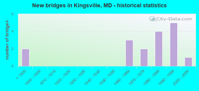
- New bridges - historical statistics
- 2Before 1900
- 31960-1969
- 21970-1979
- 41980-1989
- 51990-1999
- 12000-2009

- Reconstructed bridges - Historical Statistics
- 21960-1969
- 01970-1979
- 01980-1989
- 01990-1999
- 12000-2009
- 12010-2019


- Bridge Condition - Deck
- 9.1%Very good
- 54.5%Good
- 36.4%Satisfactory

- Bridge Condition - Superstructure
- 9.1%Very good
- 72.7%Good
- 18.2%Satisfactory

- Bridge Condition - Substructure
- 90.9%Good
- 9.1%Satisfactory

- Bridge Condition - Channel
- 7.1%Very good
- 42.9%Good
- 42.9%Satisfactory
- 7.1%Fair

- Bridge Condition - Culverts
- 33.3%Good
- 66.7%Satisfactory
Find on map >> Show street view
Structure Number: 10000003001301, Location: 1.74 MI S OF HARFORD CO (Lat: 39.414089, Lng: -76.406283), Route carried "on" structure: State highway 7, Year Built: 1987, Status: Open, Structure Length: 7.07m (23.20ft), Average Daily Traffic: 10,940 (year 2009), Truck Traffic: 8%, Average Future Daily Traffic: 13,225 (year 2026), Design Load: HS 20, Features Intersected: GUNPOWDER FALLS
Minimum Vertical Clearance: 30+ m (98+ ft), Kilometerpoint: 15.720, Lanes on structure: 2, Owner: State Highway Agency, Approaching Roadway Width: 9.8m (32.2ft), Material/Design: Steel, Design/Construction: Arch - Deck, Number Of Spans In Main Unit: 1, Length of Maximum Span: 37.8m (124.0ft), Curb-To-Curb Width: 9.8m (32.2ft), Out-to-Out Width: 10.7m (35.1ft)
Condition: Deck: Good, Superstructure: Good, Substructure: Good, Channel: Very good, Operating Rating: 59.4 metric tons, Method Used To Determine Operating Rating: Load Factor (LF), Inventory Rating: 35.4 metric tons, Method Used To Determine Inventory Rating: Load Factor (LF), Structural Evaluation: Better than present minimum criteria, Deck Geometry: Meets minimum limits, Waterway Adequacy: Superior to present desirable criteria, Approach Roadway Alignment: Equal to present minimum criteria, Designated Inspection Frequency: Every 24 months, Inspection Date: January 2021, Deck Structure Type: Concrete Cast-file-Place, Wearing Surface/Protective System: Wearing Surface: Monolithic Concrete, Deck Protection: Epoxy Coated Reinforcing
Find on map >> Show street view
Structure Number: 10000003029502, Location: 2.03 MI S OF HARFORD CO (Lat: 39.411056, Lng: -76.409336), Route carried "on" structure: State highway 7, Year Built: 1975, Status: Open, Structure Length: 0.66m (2.17ft), Average Daily Traffic: 11,470 (year 2006), Truck Traffic: 8%, Average Future Daily Traffic: 13,225 (year 2026), Design Load: HS 20, Features Intersected: BEAN BRANCH
Minimum Vertical Clearance: 30+ m (98+ ft), Kilometerpoint: 15.253, Lanes on structure: 2, Owner: State Highway Agency, Approaching Roadway Width: 13.4m (44.0ft), Skew: 1 degrees, Material/Design: Concrete, Design/Construction: Culvert, Length of Maximum Span: 3.0m (9.8ft)
Condition: Channel: Satisfactory, Culverts: Satisfactory, Operating Rating: 70.3 metric tons, Method Used To Determine Operating Rating: Load Factor (LF), Inventory Rating: 42.2 metric tons, Method Used To Determine Inventory Rating: Load Factor (LF), Structural Evaluation: Equal to present minimum criteria, Waterway Adequacy: Equal to present desirable criteria, Approach Roadway Alignment: Equal to present desirable criteria, Designated Inspection Frequency: Every 24 months, Inspection Date: July 2021
Find on map >> Show street view
Structure Number: 200000B-000101, Location: 0.29 MI SE OF JERICHO RD (Lat: 39.447178, Lng: -76.381156), Route carried "on" structure: County highway 3925, Year Built: 1894, Year Reconstructed: 2000, Status: Posted for load, Structure Length: 2.35m (7.71ft), Average Daily Traffic: 552 (year 2021), Truck Traffic: 5%, Average Future Daily Traffic: 820 (year 2041), Design Load: H 15, Features Intersected: LITTLE GUNPOWDER FALLS, Facility Carried by Structure: VINEGAR HILL ROAD
Minimum Vertical Clearance: 30+ m (98+ ft), Kilometerpoint: 0.467, Lanes on structure: 1, Owner: County Highway Agency, Approaching Roadway Width: 4.6m (15.1ft), Material/Design: Aluminum, Iron, Design/Construction: Truss - Thru, Number Of Spans In Main Unit: 1, Length of Maximum Span: 22.6m (74.1ft), Curb-To-Curb Width: 4.3m (14.1ft), Out-to-Out Width: 4.7m (15.4ft)
Condition: Deck: Satisfactory, Superstructure: Satisfactory, Substructure: Good, Channel: Good, Operating Rating: 39.9 metric tons, Method Used To Determine Operating Rating: Load Factor (LF), Inventory Rating: 24.0 metric tons, Method Used To Determine Inventory Rating: Load Factor (LF), Structural Evaluation: Equal to present minimum criteria, Deck Geometry: High priority of replacement, Waterway Adequacy: Equal to present desirable criteria, Approach Roadway Alignment: High priority of corrective action, Length Of Structure Improvement: 2.35m (7.71ft), Designated Inspection Frequency: Every 24 months, Critical Feature Inspection Frequency: Every 24 months, Inspection Date: April 2021, Critical Feature Inspection Date: April 2021, Bridge Improvement Cost: $12,000, Total Project Cost: $12,000, Deck Structure Type: Wood or Timber
Find on map >> Show street view
Structure Number: 200000B-000401, Location: 0.2 MI S JERUSALEM ROAD (Lat: 39.459675, Lng: -76.387469), Route carried "on" structure: County highway 6374, Year Built: 1865, Year Reconstructed: 2015, Status: Posted for load, Structure Length: 2.83m (9.28ft), Average Daily Traffic: 530 (year 2020), Truck Traffic: 5%, Average Future Daily Traffic: 625 (year 2040), Design Load: H 10, Features Intersected: LITTLE GUNPOWDER FALLS, Facility Carried by Structure: JERICHO ROAD
Minimum Vertical Clearance: 3.66m (12.01ft), Kilometerpoint: 0.483, Lanes on structure: 1, Owner: County Highway Agency, Approaching Roadway Width: 4.9m (16.1ft), Material/Design: Steel, Design/Construction: Stringer/Multi-beam, Number Of Spans In Main Unit: 1, Length of Maximum Span: 26.2m (86.0ft), Curb or Sidewalk Widths: Left: 0.2m (0.7ft), Right: 0.2m (0.7ft), Curb-To-Curb Width: 4.0m (13.1ft), Out-to-Out Width: 4.3m (14.1ft)
Condition: Deck: Good, Superstructure: Good, Substructure: Good, Channel: Good, Operating Rating: 26.3 metric tons, Method Used To Determine Operating Rating: Load Factor (LF), Inventory Rating: 15.9 metric tons, Method Used To Determine Inventory Rating: Load Factor (LF), Structural Evaluation: Meets minimum limits, Deck Geometry: High priority of replacement, Waterway Adequacy: Better than present minimum criteria, Approach Roadway Alignment: Equal to present minimum criteria, Bridge Posting: Required (Relationship of Operating Rating to Maximum Legal Load: 20.0 - 29.9% below), Length Of Structure Improvement: 3.96m (12.99ft), Designated Inspection Frequency: Every 24 months, Other Special Inspection Frequency: Every 12 months, Inspection Date: April 2020, Other Special Inspection Date: April 2021, Bridge Improvement Cost: $199,000, Roadway Improvement Cost: $23,000, Total Project Cost: $222,000, Deck Structure Type: Wood or Timber
Find on map >> Show street view
Structure Number: 200000B-000501, Location: 2 MI E OF US RTE 1 (Lat: 39.462519, Lng: -76.391828), Route carried "on" structure: County highway 3918, Year Built: 1993, Status: Open, Structure Length: 2.77m (9.09ft), Average Daily Traffic: 3,035 (year 2020), Truck Traffic: 5%, Average Future Daily Traffic: 6,701 (year 2040), Design Load: HS 20, Features Intersected: LITTLE GUNPOWDER FALLS, Facility Carried by Structure: JERUSALEM ROAD
Minimum Vertical Clearance: 30+ m (98+ ft), Kilometerpoint: 2.896, Lanes on structure: 2, Owner: County Highway Agency, Approaching Roadway Width: 5.5m (18.0ft), Material/Design: Prestressed concrete, Design/Construction: Box Beam or Girders - Multiple, Number Of Spans In Main Unit: 1, Length of Maximum Span: 26.2m (86.0ft), Curb or Sidewalk Widths: Left: 0.2m (0.7ft), Right: 0.2m (0.7ft), Curb-To-Curb Width: 7.3m (24.0ft), Out-to-Out Width: 8.4m (27.6ft)
Condition: Deck: Good, Superstructure: Good, Substructure: Good, Channel: Satisfactory, Inventory Rating: 78.9 metric tons, Method Used To Determine Inventory Rating: Load Factor (LF), Structural Evaluation: Better than present minimum criteria, Deck Geometry: High priority of replacement, Waterway Adequacy: Equal to present desirable criteria, Approach Roadway Alignment: Equal to present minimum criteria, Designated Inspection Frequency: Every 24 months, Inspection Date: January 2020, Deck Structure Type: Concrete Precast Panels, Wearing Surface/Protective System: Wearing Surface: Bituminous, Membrane: Other, Deck Protection: Epoxy Coated Reinforcing
Find on map >> Show street view
Structure Number: 200000B-004101, Location: 0.2 MI SE OF GLEN ARM RD (Lat: 39.455686, Lng: -76.479589), Route carried "on" structure: County highway 3886, Year Built: 1988, Status: Open, Structure Length: 1.86m (6.10ft), Average Daily Traffic: 1,700 (year 2015), Truck Traffic: 5%, Average Future Daily Traffic: 2,845 (year 2039), Features Intersected: LONG GREEN CREEK, Facility Carried by Structure: HARTLEY MILL RD
Minimum Vertical Clearance: 30+ m (98+ ft), Kilometerpoint: 0.209, Lanes on structure: 1, Owner: County Highway Agency, Approaching Roadway Width: 4.3m (14.1ft), Material/Design: Steel, Design/Construction: Truss - Thru, Number Of Spans In Main Unit: 1, Length of Maximum Span: 18.6m (61.0ft), Curb-To-Curb Width: 4.1m (13.5ft), Out-to-Out Width: 4.1m (13.5ft)
Condition: Deck: Satisfactory, Superstructure: Good, Substructure: Good, Channel: Satisfactory, Operating Rating: 44.0 metric tons, Method Used To Determine Operating Rating: Load Factor (LF), Inventory Rating: 26.3 metric tons, Method Used To Determine Inventory Rating: Load Factor (LF), Structural Evaluation: Equal to present minimum criteria, Deck Geometry: High priority of replacement, Waterway Adequacy: Better than present minimum criteria, Approach Roadway Alignment: High priority of corrective action, Length Of Structure Improvement: 2.74m (8.99ft), Designated Inspection Frequency: Every 24 months, Critical Feature Inspection Frequency: Every 24 months, Inspection Date: August 2021, Critical Feature Inspection Date: August 2021, Bridge Improvement Cost: $1,440,000, Roadway Improvement Cost: $144,000, Total Project Cost: $1,584,000, Deck Structure Type: Steel plate, Wearing Surface/Protective System: Wearing Surface: Other
Find on map >> Show street view
Structure Number: 200000B-007401, Location: 0.6 MI W OF HARFORD RD (Lat: 39.457081, Lng: -76.480950), Route carried "on" structure: County highway 6933, Year Built: 1976, Status: Open, Structure Length: 0.98m (3.22ft), Average Daily Traffic: 6,382 (year 2020), Truck Traffic: 5%, Average Future Daily Traffic: 8,337 (year 2040), Design Load: HS 20, Features Intersected: BRANCH OF LONG GREEN CRE, Facility Carried by Structure: GLEN ARM ROAD
Minimum Vertical Clearance: 30+ m (98+ ft), Kilometerpoint: 3.073, Lanes on structure: 2, Owner: County Highway Agency, Approaching Roadway Width: 12.2m (40.0ft), Skew: 1 degrees, Material/Design: Prestressed concrete, Design/Construction: Box Beam or Girders - Multiple, Number Of Spans In Main Unit: 1, Length of Maximum Span: 9.1m (29.9ft), Curb-To-Curb Width: 12.3m (40.4ft), Out-to-Out Width: 13.3m (43.6ft)
Condition: Deck: Good, Superstructure: Good, Substructure: Good, Channel: Satisfactory, Operating Rating: 77.5 metric tons, Method Used To Determine Operating Rating: Load Factor (LF), Inventory Rating: 46.3 metric tons, Method Used To Determine Inventory Rating: Load Factor (LF), Structural Evaluation: Better than present minimum criteria, Deck Geometry: Somewhat better than minimum adequacy, Waterway Adequacy: Equal to present minimum criteria, Approach Roadway Alignment: Equal to present minimum criteria, Designated Inspection Frequency: Every 24 months, Inspection Date: April 2021, Deck Structure Type: Concrete Precast Panels, Wearing Surface/Protective System: Wearing Surface: Bituminous
Find on map >> Show street view
Structure Number: 200000B-014204, Location: 0.3 MI NW PULASKI HWY (Lat: 39.401006, Lng: -76.407250), Route carried "on" structure: County highway 3952, Year Built: 1998, Status: Open, Structure Length: 5.79m (19.00ft), Average Daily Traffic: 5,282 (year 2017), Truck Traffic: 5%, Average Future Daily Traffic: 6,444 (year 2037), Design Load: HS 20, Features Intersected: CSX RAILROAD, Facility Carried by Structure: ALLENDER ROAD
Minimum Vertical Clearance: 30+ m (98+ ft), Kilometerpoint: 1.062, Lanes on structure: 2, Owner: County Highway Agency, Approaching Roadway Width: 9.1m (29.9ft), Material/Design: Steel, Design/Construction: Frame, Number Of Spans In Main Unit: 3, Length of Maximum Span: 30.2m (99.1ft), Curb or Sidewalk Widths: Left: 1.6m (5.2ft), Right: 1.6m (5.2ft), Curb-To-Curb Width: 9.1m (29.9ft), Out-to-Out Width: 12.9m (42.3ft)
Condition: Deck: Good, Superstructure: Good, Substructure: Good, Operating Rating: 72.1 metric tons, Method Used To Determine Operating Rating: Load Factor (LF), Inventory Rating: 43.1 metric tons, Method Used To Determine Inventory Rating: Load Factor (LF), Structural Evaluation: Better than present minimum criteria, Deck Geometry: High priority of corrective action, Underclear: Superior to present desirable criteria, Approach Roadway Alignment: Equal to present desirable criteria, Designated Inspection Frequency: Every 24 months, Inspection Date: September 2021, Deck Structure Type: Concrete Cast-file-Place, Wearing Surface/Protective System: Wearing Surface: Integral Concrete, Deck Protection: Epoxy Coated Reinforcing
Find on map >> Show street view
Structure Number: 200000B-022302, Location: 1.28 MI E OF US RTE 1 (Lat: 39.427436, Lng: -76.411178), Route carried "on" structure: County highway 3900, Year Built: 1984, Status: Open, Structure Length: 0.67m (2.20ft), Average Daily Traffic: 1,713 (year 2020), Truck Traffic: 10%, Average Future Daily Traffic: 2,091 (year 2040), Design Load: HS 20, Features Intersected: BRANCH OF GUNPOWDER FALL, Facility Carried by Structure: MOUNT VISTA ROAD
Minimum Vertical Clearance: 30+ m (98+ ft), Kilometerpoint: 0.290, Lanes on structure: 2, Base Highway Network: Yes, Owner: County Highway Agency, Approaching Roadway Width: 9.8m (32.2ft), Skew: 3 degrees, Material/Design: Concrete, Design/Construction: Culvert, Length of Maximum Span: 2.7m (8.9ft)
Condition: Channel: Satisfactory, Culverts: Good, Inventory Rating: 74.8 metric tons, Method Used To Determine Inventory Rating: Load Factor (LF), Structural Evaluation: Better than present minimum criteria, Waterway Adequacy: Better than present minimum criteria, Approach Roadway Alignment: Equal to present desirable criteria, Designated Inspection Frequency: Every 24 months, Inspection Date: April 2021
Find on map >> Show street view
Structure Number: 200000B-022401, Location: 0.35 MI E OF US ROUTE 1 (Lat: 39.432961, Lng: -76.425686), Route carried "on" structure: County highway 3900, Year Built: 1998, Status: Open, Structure Length: 1.16m (3.81ft), Average Daily Traffic: 1,034 (year 2019), Truck Traffic: 5%, Average Future Daily Traffic: 1,536 (year 2039), Design Load: HS 20, Features Intersected: BROAD RUN, Facility Carried by Structure: MOUNT VISTA ROAD
Minimum Vertical Clearance: 30+ m (98+ ft), Kilometerpoint: 1.786, Lanes on structure: 2, Owner: County Highway Agency, Approaching Roadway Width: 12.2m (40.0ft), Skew: 1 degrees, Material/Design: Concrete, Design/Construction: Culvert, Length of Maximum Span: 3.4m (11.2ft), Curb-To-Curb Width: 12.2m (40.0ft), Out-to-Out Width: 12.9m (42.3ft)
Condition: Channel: Good, Culverts: Good, Inventory Rating: 57.6 metric tons, Method Used To Determine Inventory Rating: Load Factor (LF), Structural Evaluation: Better than present minimum criteria, Deck Geometry: Better than present minimum criteria, Waterway Adequacy: Equal to present desirable criteria, Approach Roadway Alignment: Equal to present desirable criteria, Designated Inspection Frequency: Every 24 months, Inspection Date: October 2021, Wearing Surface/Protective System: Wearing Surface: Bituminous
Find on map >> Show street view
Structure Number: 200000B-022501, Location: 0.60 MI E OF MD 147 (Lat: 39.456494, Lng: -76.446917), Route carried "on" structure: County highway 3900, Year Built: 2008, Status: Open, Structure Length: 1.25m (4.10ft), Average Daily Traffic: 1,381 (year 2019), Truck Traffic: 5%, Average Future Daily Traffic: 3,213 (year 2039), Design Load: HS 25 or greater, Features Intersected: SWEATHOUSE BRANCH, Facility Carried by Structure: MOUNT VISTA ROAD
Minimum Vertical Clearance: 30+ m (98+ ft), Kilometerpoint: 5.149, Lanes on structure: 2, Owner: County Highway Agency, Approaching Roadway Width: 7.6m (24.9ft), Skew: 1 degrees, Material/Design: Prestressed concrete, Design/Construction: Slab, Number Of Spans In Main Unit: 1, Length of Maximum Span: 11.6m (38.1ft), Curb-To-Curb Width: 9.1m (29.9ft), Out-to-Out Width: 10.4m (34.1ft)
Condition: Deck: Very good, Superstructure: Very good, Substructure: Good, Channel: Good, Operating Rating: 79.8 metric tons, Method Used To Determine Operating Rating: Load Factor (LF), Inventory Rating: 48.1 metric tons, Method Used To Determine Inventory Rating: Load Factor (LF), Structural Evaluation: Better than present minimum criteria, Deck Geometry: Somewhat better than minimum adequacy, Waterway Adequacy: Better than present minimum criteria, Approach Roadway Alignment: Equal to present desirable criteria, Designated Inspection Frequency: Every 24 months, Inspection Date: September 2021, Deck Structure Type: Concrete Cast-file-Place, Wearing Surface/Protective System: Wearing Surface: Integral Concrete, Deck Protection: Epoxy Coated Reinforcing
Find on map >> Show street view
Structure Number: 200000B-043602, Location: 0.3 MI N FRANKLINVILLE RD (Lat: 39.453314, Lng: -76.388828), Route carried "on" structure: County highway , Year Built: 1991, Status: Open, Structure Length: 0.73m (2.40ft), Average Daily Traffic: 527 (year 2021), Truck Traffic: 5%, Average Future Daily Traffic: 582 (year 2042), Features Intersected: TRIBUTARY TO LITTLE GUNP, Facility Carried by Structure: JERICHO ROAD
Minimum Vertical Clearance: 30+ m (98+ ft), Kilometerpoint: 0.002, Lanes on structure: 2, Owner: County Highway Agency, Approaching Roadway Width: 6.1m (20.0ft), Material/Design: Concrete, Design/Construction: Culvert, Length of Maximum Span: 3.0m (9.8ft), Curb-To-Curb Width: 9.8m (32.2ft), Out-to-Out Width: 10.4m (34.1ft)
Condition: Channel: Satisfactory, Culverts: Satisfactory, Inventory Rating: 56.2 metric tons, Method Used To Determine Inventory Rating: Load Factor (LF), Structural Evaluation: Equal to present minimum criteria, Deck Geometry: Equal to present minimum criteria, Waterway Adequacy: Better than present minimum criteria, Approach Roadway Alignment: Equal to present desirable criteria, Designated Inspection Frequency: Every 24 months, Inspection Date: September 2021, Wearing Surface/Protective System: Wearing Surface: Bituminous
Find on map >> Show street view
Structure Number: 200000H-020903, Location: 100 FT S OF GREENSPRING A (Lat: 39.451297, Lng: -76.373144), Route carried "on" structure: County highway 260, Year Built: 1960, Status: Open, Structure Length: 0.70m (2.30ft), Average Daily Traffic: 232 (year 2019), Truck Traffic: 5%, Average Future Daily Traffic: 406 (year 2039), Features Intersected: TRIB / GUNPOWDER FALLS, Facility Carried by Structure: OLD JOPPA ROAD
Minimum Vertical Clearance: 30+ m (98+ ft), Kilometerpoint: 0.000, Lanes on structure: 2, Owner: County Highway Agency, Approaching Roadway Width: 6.7m (22.0ft), Material/Design: Steel, Design/Construction: Culvert, Length of Maximum Span: 1.8m (5.9ft)
Condition: Channel: Fair, Culverts: Satisfactory, Structural Evaluation: Equal to present minimum criteria, Waterway Adequacy: High priority of corrective action, Approach Roadway Alignment: Equal to present minimum criteria, Designated Inspection Frequency: Every 24 months, Inspection Date: July 2021
Find on map >> Show street view
Structure Number: 300000B-X69701, Location: Milepost M69.7 (Lat: 39.409158, Lng: -76.416378), Route carried "on" structure: County highway 6112, Year Built: 1990, Status: Open, Structure Length: 10.30m (33.79ft), Average Daily Traffic: 2,862 (year 2019), Truck Traffic: 5%, Average Future Daily Traffic: 3,410 (year 2041), Design Load: HS 20, Features Intersected: I-95, Facility Carried by Structure: NEW FORGE ROAD
Minimum Vertical Clearance: 30+ m (98+ ft), Kilometerpoint: 112.179, Lanes on structure: 2, Lanes under structure: 7, Owner: State Toll Authority, Approaching Roadway Width: 12.2m (40.0ft), Skew: 1 degrees, Material/Design: Steel continuous, Design/Construction: Stringer/Multi-beam, Number Of Spans In Main Unit: 2, Number Of Approach Spans: 2, Length of Maximum Span: 43.3m (142.1ft), Curb or Sidewalk Widths: Left: 1.3m (4.3ft), Right: 1.3m (4.3ft), Curb-To-Curb Width: 9.8m (32.2ft), Out-to-Out Width: 13.0m (42.7ft)
Condition: Deck: Satisfactory, Superstructure: Good, Substructure: Good, Operating Rating: 68.0 metric tons, Method Used To Determine Operating Rating: Load Factor (LF), Inventory Rating: 40.8 metric tons, Method Used To Determine Inventory Rating: Load Factor (LF), Structural Evaluation: Better than present minimum criteria, Deck Geometry: Meets minimum limits, Underclear: Somewhat better than minimum adequacy, Approach Roadway Alignment: Equal to present desirable criteria, Designated Inspection Frequency: Every 24 months, Inspection Date: January 2020, Deck Structure Type: Concrete Cast-file-Place, Wearing Surface/Protective System: Wearing Surface: Monolithic Concrete
Find on map >> Show street view
Structure Number: 300000B-X69902, Location: 3.5 MI N OF MD 43 (Lat: 39.409989, Lng: -76.413758), Route carried "on" structure: Interstate 95, Year Built: 1963, Year Reconstructed: 1971, Status: Open, Structure Length: 1.07m (3.51ft), Average Daily Traffic: 172,113 (year 2019), Truck Traffic: 12%, Average Future Daily Traffic: 228,677 (year 2041), Design Load: HS 20, Features Intersected: GUNPOWDER FALLS
Minimum Vertical Clearance: 30+ m (98+ ft), Kilometerpoint: 112.405, Lanes on structure: 8, Base Highway Network: Yes, Toll: On toll road, Owner: State Toll Authority, Approaching Roadway Width: 42.7m (140.1ft), Skew: 3 degrees, Material/Design: Concrete, Design/Construction: Culvert, Number Of Spans In Main Unit: 2, Length of Maximum Span: 4.6m (15.1ft)
Condition: Channel: Good, Culverts: Satisfactory, Structural Evaluation: Equal to present minimum criteria, Waterway Adequacy: Equal to present minimum criteria, Approach Roadway Alignment: Equal to present desirable criteria, Designated Inspection Frequency: Every 24 months, Inspection Date: September 2021
Find on map >> Show street view
Structure Number: 300000B-X70301, Location: 2.3 MI S BALT-HAR CO LINE (Lat: 39.415300, Lng: -76.409531), Route carried "on" structure: Interstate 95, Year Built: 1963, Year Reconstructed: 1971, Status: Open, Structure Length: 9.91m (32.51ft), Average Daily Traffic: 178,830 (year 2019), Truck Traffic: 8%, Average Future Daily Traffic: 250,841 (year 2041), Design Load: HS 20, Features Intersected: GUNPOWDER FALLS
Minimum Vertical Clearance: 30+ m (98+ ft), Kilometerpoint: 113.145, Lanes on structure: 8, Base Highway Network: Yes, Owner: State Toll Authority, Approaching Roadway Width: 43.9m (144.0ft), Skew: 31 degrees, Material/Design: Steel, Design/Construction: Stringer/Multi-beam, Number Of Spans In Main Unit: 4, Length of Maximum Span: 24.7m (81.0ft), Curb-To-Curb Width: 44.2m (145.0ft), Out-to-Out Width: 46.2m (151.6ft)
Condition: Deck: Satisfactory, Superstructure: Satisfactory, Substructure: Satisfactory, Channel: Good, Operating Rating: 83.9 metric tons, Method Used To Determine Operating Rating: Load Factor (LF), Inventory Rating: 50.3 metric tons, Method Used To Determine Inventory Rating: Load Factor (LF), Structural Evaluation: Equal to present minimum criteria, Deck Geometry: Superior to present desirable criteria, Waterway Adequacy: Equal to present desirable criteria, Approach Roadway Alignment: Equal to present desirable criteria, Designated Inspection Frequency: Every 24 months, Inspection Date: September 2021, Deck Structure Type: Concrete Cast-file-Place, Wearing Surface/Protective System: Wearing Surface: Latex Concrete
Find on map >> Show street view
Structure Number: 300000B-X70701, Location: Milepost M70.7 (Lat: 39.420214, Lng: -76.405214), Route carried "on" structure: County highway 3940, Year Built: 1989, Status: Open, Structure Length: 8.35m (27.40ft), Average Daily Traffic: 5,392 (year 2019), Truck Traffic: 1%, Average Future Daily Traffic: 6,425 (year 2041), Design Load: HS 25 or greater, Features Intersected: I-95, Facility Carried by Structure: RAPHEL ROAD
Minimum Vertical Clearance: 30+ m (98+ ft), Kilometerpoint: 113.772, Lanes on structure: 2, Lanes under structure: 8, Owner: State Toll Authority, Approaching Roadway Width: 12.2m (40.0ft), Material/Design: Steel continuous, Design/Construction: Stringer/Multi-beam, Number Of Spans In Main Unit: 2, Number Of Approach Spans: 2, Length of Maximum Span: 36.0m (118.1ft), Curb or Sidewalk Widths: Left: 0.0m, Right: 1.5m (4.9ft), Curb-To-Curb Width: 9.8m (32.2ft), Out-to-Out Width: 12.3m (40.4ft)
Condition: Deck: Good, Superstructure: Good, Substructure: Good, Inventory Rating: 68.9 metric tons, Method Used To Determine Inventory Rating: Load Factor (LF), Structural Evaluation: Better than present minimum criteria, Deck Geometry: Meets minimum limits, Underclear: Meets minimum limits, Approach Roadway Alignment: Better than present minimum criteria, Designated Inspection Frequency: Every 24 months, Inspection Date: September 2021, Deck Structure Type: Concrete Cast-file-Place, Wearing Surface/Protective System: Wearing Surface: Monolithic Concrete