Bridge Statistics for Kingston, Michigan (MI)
Condition, Traffic, Stress, Structural Evaluation, Project Costs
- National Bridge Inventory (NBI) Statistics
- 16Number of bridges
- 72ft / 22.3mTotal length
- $803,000Total costs
- 10,136Total average daily traffic
- 321Total average daily truck traffic
- 17,023Total future (year 2018) average daily traffic
- National Bridge Inventory (NBI) Registered Bridges for Kingston
- No street view available for this location
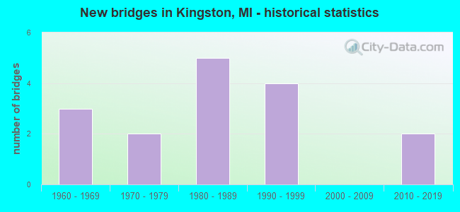
- New bridges - historical statistics
- 31960-1969
- 21970-1979
- 51980-1989
- 41990-1999
- 22010-2019


- Bridge Condition - Deck
- 46.2%Good
- 46.2%Satisfactory
- 7.7%Fair

- Bridge Condition - Superstructure
- 61.5%Good
- 23.1%Satisfactory
- 15.4%Fair

- Bridge Condition - Substructure
- 92.3%Good
- 7.7%Satisfactory

- Bridge Condition - Channel
- 6.3%Very good
- 31.3%Good
- 56.3%Satisfactory
- 6.3%Fair

- Bridge Condition - Culverts
- 66.7%Very good
- 33.3%Serious
Find on map >> Show street view
Structure Number: 10425, Location: 6.9 MI E OF M-24 (Lat: 43.411733, Lng: -83.245764), Route carried "on" structure: State highway 46, Year Built: 1967, Year Reconstructed: 1988, Status: Open, Structure Length: 2.13m (6.99ft), Average Daily Traffic: 3,520 (year 2007), Truck Traffic: 9%, Average Future Daily Traffic: 5,111 (year 2018), Design Load: H 20, Features Intersected: SUCKER CREEK
Minimum Vertical Clearance: 30.48m (100.00ft), Kilometerpoint: 36.678, Lanes on structure: 2, Base Highway Network: Yes (Inventory Route: 27, Subroute: 8), Owner: State Highway Agency, Approaching Roadway Width: 12.2m (40.0ft), Material/Design: Concrete continuous, Design/Construction: Slab, Number Of Spans In Main Unit: 3, Length of Maximum Span: 8.5m (27.9ft), Curb-To-Curb Width: 13.4m (44.0ft), Out-to-Out Width: 14.6m (47.9ft)
Condition: Deck: Fair, Superstructure: Fair, Substructure: Satisfactory, Channel: Satisfactory, Operating Rating: 51.5 metric tons, Method Used To Determine Operating Rating: Load Factor (LF) rating reported by rating factor (RF) method using MS18 loading, Inventory Rating: 30.8 metric tons, Method Used To Determine Inventory Rating: Load Factor (LF) rating reported by rating factor (RF) method using MS18 loading, Structural Evaluation: Somewhat better than minimum adequacy, Deck Geometry: Better than present minimum criteria, Waterway Adequacy: Somewhat better than minimum adequacy, Approach Roadway Alignment: Equal to present minimum criteria, Designated Inspection Frequency: Every 24 months, Inspection Date: August 2020, Deck Structure Type: Concrete Cast-file-Place, Wearing Surface/Protective System: Wearing Surface: Monolithic Concrete, Deck Protection: Epoxy Coated Reinforcing
Find on map >> Show street view
Structure Number: 10459, Location: SEC 13-24 WELLS TWP (Lat: 43.455439, Lng: -83.232489), Route carried "on" structure: County highway 7954, Year Built: 1971, Status: Open, Structure Length: 0.73m (2.40ft), Average Daily Traffic: 1,970 (year 2009), Average Future Daily Traffic: 3,560 (year 2029), Design Load: HS 20, Features Intersected: BUTTERNUT CREEK DRAIN, Facility Carried by Structure: BEVENS ROAD
Minimum Vertical Clearance: 30.48m (100.00ft), Kilometerpoint: 3.999, Lanes on structure: 2, Owner: County Highway Agency, Approaching Roadway Width: 10.4m (34.1ft), Material/Design: Prestressed concrete, Design/Construction: Box Beam or Girders - Multiple, Number Of Spans In Main Unit: 1, Length of Maximum Span: 6.9m (22.6ft), Curb-To-Curb Width: 10.6m (34.8ft), Out-to-Out Width: 11.2m (36.7ft)
Condition: Deck: Satisfactory, Superstructure: Satisfactory, Substructure: Good, Channel: Good, Operating Rating: 79.7 metric tons, Method Used To Determine Operating Rating: Load Factor (LF) rating reported by rating factor (RF) method using MS18 loading, Inventory Rating: 47.6 metric tons, Method Used To Determine Inventory Rating: Load Factor (LF) rating reported by rating factor (RF) method using MS18 loading, Structural Evaluation: Equal to present minimum criteria, Deck Geometry: Equal to present minimum criteria, Waterway Adequacy: Better than present minimum criteria, Approach Roadway Alignment: Equal to present desirable criteria, Designated Inspection Frequency: Every 24 months, Inspection Date: April 2021, Deck Structure Type: Concrete Precast Panels, Wearing Surface/Protective System: Wearing Surface: Bituminous
Find on map >> Show street view
Structure Number: 1046, Location: SEC 16-21 KINGSTON TWP (Lat: 43.456214, Lng: -83.182911), Route carried "on" structure: County highway 7954, Year Built: 1984, Status: Open, Structure Length: 1.83m (6.00ft), Average Daily Traffic: 1,245 (year 2009), Average Future Daily Traffic: 2,250 (year 2029), Design Load: HS 20, Features Intersected: CLARK DRAIN EXTENSION, Facility Carried by Structure: BEVENS ROAD
Minimum Vertical Clearance: 30.48m (100.00ft), Kilometerpoint: 18.030, Lanes on structure: 2, Owner: County Highway Agency, Approaching Roadway Width: 9.8m (32.2ft), Material/Design: Prestressed concrete, Design/Construction: Box Beam or Girders - Multiple, Number Of Spans In Main Unit: 1, Length of Maximum Span: 17.9m (58.7ft), Curb-To-Curb Width: 11.3m (37.1ft), Out-to-Out Width: 11.4m (37.4ft)
Condition: Deck: Satisfactory, Superstructure: Good, Substructure: Good, Channel: Good, Operating Rating: 74.5 metric tons, Method Used To Determine Operating Rating: Load Factor (LF) rating reported by rating factor (RF) method using MS18 loading, Inventory Rating: 44.7 metric tons, Method Used To Determine Inventory Rating: Load Factor (LF) rating reported by rating factor (RF) method using MS18 loading, Structural Evaluation: Better than present minimum criteria, Deck Geometry: Equal to present minimum criteria, Waterway Adequacy: Better than present minimum criteria, Approach Roadway Alignment: Equal to present desirable criteria, Designated Inspection Frequency: Every 24 months, Inspection Date: June 2021, Deck Structure Type: Concrete Precast Panels, Wearing Surface/Protective System: Wearing Surface: Bituminous, Deck Protection: Epoxy Coated Reinforcing
Find on map >> Show street view
Structure Number: 10514, Location: SEC 16-17 KINGSTON TWP (Lat: 43.460092, Lng: -83.187456), Route carried "on" structure: County highway 7987, Year Built: 1986, Status: Open, Structure Length: 2.07m (6.79ft), Average Daily Traffic: 1,390 (year 2009), Average Future Daily Traffic: 2,510 (year 2029), Design Load: HS 20, Features Intersected: CLARK DRAIN EXTENSION, Facility Carried by Structure: KINGSTON ROAD
Minimum Vertical Clearance: 30.48m (100.00ft), Kilometerpoint: 5.237, Lanes on structure: 2, Owner: County Highway Agency, Approaching Roadway Width: 9.8m (32.2ft), Material/Design: Prestressed concrete, Design/Construction: Box Beam or Girders - Multiple, Number Of Spans In Main Unit: 1, Length of Maximum Span: 20.3m (66.6ft), Curb-To-Curb Width: 12.2m (40.0ft), Out-to-Out Width: 13.3m (43.6ft)
Condition: Deck: Good, Superstructure: Good, Substructure: Good, Channel: Good, Operating Rating: 92.0 metric tons, Method Used To Determine Operating Rating: Load Factor (LF) rating reported by rating factor (RF) method using MS18 loading, Inventory Rating: 55.1 metric tons, Method Used To Determine Inventory Rating: Load Factor (LF) rating reported by rating factor (RF) method using MS18 loading, Structural Evaluation: Better than present minimum criteria, Deck Geometry: Better than present minimum criteria, Waterway Adequacy: Equal to present desirable criteria, Approach Roadway Alignment: Equal to present minimum criteria, Designated Inspection Frequency: Every 24 months, Inspection Date: June 2021, Deck Structure Type: Concrete Precast Panels, Wearing Surface/Protective System: Wearing Surface: Bituminous, Membrane: Preformed Fabric, Deck Protection: Epoxy Coated Reinforcing
Find on map >> Show street view
Structure Number: 10565, Location: SEC 11-14 DAYTON TWP (Lat: 43.382561, Lng: -83.246150), Route carried "on" structure: ServiceCounty highway , Year Built: 2018, Status: Open, Structure Length: 0.79m (2.59ft), Average Daily Traffic: 480 (year 2009), Average Future Daily Traffic: 870 (year 2029), Design Load: HL 93, Features Intersected: SUCKER CREEK DRAIN, Facility Carried by Structure: SHAYS LAKE ROAD
Minimum Vertical Clearance: 30.48m (100.00ft), Kilometerpoint: 4.690, Lanes on structure: 2, Owner: County Highway Agency, Approaching Roadway Width: 8.5m (27.9ft), Material/Design: Concrete, Design/Construction: Culvert, Number Of Spans In Main Unit: 1, Length of Maximum Span: 7.3m (24.0ft), Curb-To-Curb Width: 8.5m (27.9ft), Out-to-Out Width: 11.0m (36.1ft)
Condition: Channel: Very good, Culverts: Very good, Operating Rating: 65.4 metric tons, Method Used To Determine Operating Rating: Load and Resistance Factor Rating (LRFR) rating reported by rating factor(RF) method using HL-93 loadings, Inventory Rating: 50.9 metric tons, Method Used To Determine Inventory Rating: Load and Resistance Factor Rating (LRFR) rating reported by rating factor(RF) method using HL-93 loadings, Structural Evaluation: Equal to present desirable criteria, Deck Geometry: Somewhat better than minimum adequacy, Waterway Adequacy: Better than present minimum criteria, Approach Roadway Alignment: Equal to present desirable criteria, Length Of Structure Improvement: 1.65m (5.41ft), Designated Inspection Frequency: Every 24 months, Inspection Date: November 2020, Bridge Improvement Cost: $479,000, Roadway Improvement Cost: $189,000, Total Project Cost: $803,000 ( Estimate for 2017), Wearing Surface/Protective System: Wearing Surface: Bituminous
Find on map >> Show street view
Structure Number: 10567, Location: SEC 1-12 DAYTON TWP (Lat: 43.397092, Lng: -83.243028), Route carried "on" structure: ServiceCounty highway , Year Built: 1983, Status: Open, Structure Length: 0.85m (2.79ft), Average Daily Traffic: 50 (year 2009), Average Future Daily Traffic: 90 (year 2029), Design Load: HS 20, Features Intersected: SUCKER CREEK DRAIN, Facility Carried by Structure: HARMON LAKE ROAD
Minimum Vertical Clearance: 30.48m (100.00ft), Kilometerpoint: 1.772, Lanes on structure: 2, Owner: County Highway Agency, Approaching Roadway Width: 9.8m (32.2ft), Material/Design: Prestressed concrete, Design/Construction: Tee Beam, Number Of Spans In Main Unit: 1, Length of Maximum Span: 8.3m (27.2ft), Curb-To-Curb Width: 9.1m (29.9ft), Out-to-Out Width: 9.9m (32.5ft)
Condition: Deck: Good, Superstructure: Good, Substructure: Good, Channel: Satisfactory, Operating Rating: 79.4 metric tons, Method Used To Determine Operating Rating: Load Factor (LF) rating reported by rating factor (RF) method using MS18 loading, Inventory Rating: 48.0 metric tons, Method Used To Determine Inventory Rating: Load Factor (LF) rating reported by rating factor (RF) method using MS18 loading, Structural Evaluation: Better than present minimum criteria, Deck Geometry: Better than present minimum criteria, Waterway Adequacy: Better than present minimum criteria, Approach Roadway Alignment: Equal to present desirable criteria, Designated Inspection Frequency: Every 24 months, Inspection Date: April 2021, Deck Structure Type: Concrete Precast Panels, Wearing Surface/Protective System: Wearing Surface: Bituminous, Deck Protection: Epoxy Coated Reinforcing
Find on map >> Show street view
Structure Number: 10613, Location: SEC 27-34 KINGSTON TWP (Lat: 43.427808, Lng: -83.157839), Route carried "on" structure: ServiceCounty highway , Year Built: 1983, Status: Open, Structure Length: 1.62m (5.31ft), Average Daily Traffic: 110 (year 2009), Average Future Daily Traffic: 200 (year 2029), Design Load: HS 20, Features Intersected: WHITE CREEK DRAIN #2, Facility Carried by Structure: ROSSMAN ROAD
Minimum Vertical Clearance: 30.48m (100.00ft), Kilometerpoint: 15.135, Lanes on structure: 2, Owner: County Highway Agency, Approaching Roadway Width: 8.5m (27.9ft), Material/Design: Prestressed concrete, Design/Construction: Tee Beam, Number Of Spans In Main Unit: 1, Length of Maximum Span: 15.3m (50.2ft), Curb-To-Curb Width: 9.3m (30.5ft), Out-to-Out Width: 10.0m (32.8ft)
Condition: Deck: Satisfactory, Superstructure: Satisfactory, Substructure: Good, Channel: Satisfactory, Operating Rating: 49.9 metric tons, Method Used To Determine Operating Rating: Load Factor (LF) rating reported by rating factor (RF) method using MS18 loading, Inventory Rating: 30.1 metric tons, Method Used To Determine Inventory Rating: Load Factor (LF) rating reported by rating factor (RF) method using MS18 loading, Structural Evaluation: Equal to present minimum criteria, Deck Geometry: Equal to present minimum criteria, Waterway Adequacy: Better than present minimum criteria, Approach Roadway Alignment: Equal to present desirable criteria, Designated Inspection Frequency: Every 24 months, Inspection Date: June 2021, Deck Structure Type: Concrete Precast Panels, Wearing Surface/Protective System: Wearing Surface: Bituminous, Deck Protection: Epoxy Coated Reinforcing
Find on map >> Show street view
Structure Number: 10614, Location: SEC 21-28 KINGSTON TWP (Lat: 43.441908, Lng: -83.178522), Route carried "on" structure: ServiceCounty highway , Year Built: 2015, Status: Open, Structure Length: 1.16m (3.81ft), Average Daily Traffic: 116 (year 2014), Truck Traffic: 5%, Average Future Daily Traffic: 172 (year 2034), Design Load: Greater than HL93, Features Intersected: WHITE CREEK DRAIN #2, Facility Carried by Structure: LEGG ROAD
Minimum Vertical Clearance: 30.48m (100.00ft), Kilometerpoint: 2.300, Lanes on structure: 2, Owner: County Highway Agency, Approaching Roadway Width: 7.9m (25.9ft), Material/Design: Concrete, Design/Construction: Culvert, Number Of Spans In Main Unit: 1, Length of Maximum Span: 11.0m (36.1ft), Curb-To-Curb Width: 7.9m (25.9ft), Out-to-Out Width: 20.1m (65.9ft)
Condition: Channel: Satisfactory, Culverts: Very good, Operating Rating: 97.2 metric tons, Method Used To Determine Operating Rating: Load and Resistance Factor Rating (LRFR) rating reported by rating factor(RF) method using HL-93 loadings, Inventory Rating: 97.2 metric tons, Method Used To Determine Inventory Rating: Load and Resistance Factor Rating (LRFR) rating reported by rating factor(RF) method using HL-93 loadings, Structural Evaluation: Equal to present desirable criteria, Deck Geometry: Somewhat better than minimum adequacy, Waterway Adequacy: Equal to present desirable criteria, Approach Roadway Alignment: Equal to present desirable criteria, Designated Inspection Frequency: Every 24 months, Inspection Date: July 2021, Wearing Surface/Protective System: Wearing Surface: Monolithic Concrete
Find on map >> Show street view
Structure Number: 10615, Location: SEC 17 KINGSTON TWP (Lat: 43.464569, Lng: -83.195781), Route carried "on" structure: ServiceCounty highway , Year Built: 1968, Status: Open, Structure Length: 1.23m (4.04ft), Average Daily Traffic: 85 (year 2009), Average Future Daily Traffic: 150 (year 2029), Design Load: H 20, Features Intersected: SOUTH BR WHITE CREEK, Facility Carried by Structure: BOND ROAD
Minimum Vertical Clearance: 30.48m (100.00ft), Kilometerpoint: 0.970, Lanes on structure: 2, Owner: County Highway Agency, Approaching Roadway Width: 7.9m (25.9ft), Material/Design: Steel, Design/Construction: Stringer/Multi-beam, Number Of Spans In Main Unit: 1, Length of Maximum Span: 11.9m (39.0ft), Curb-To-Curb Width: 9.1m (29.9ft), Out-to-Out Width: 9.2m (30.2ft)
Condition: Deck: Satisfactory, Superstructure: Fair, Substructure: Good, Channel: Satisfactory, Operating Rating: 62.2 metric tons, Method Used To Determine Operating Rating: Load Factor (LF) rating reported by rating factor (RF) method using MS18 loading, Inventory Rating: 37.3 metric tons, Method Used To Determine Inventory Rating: Load Factor (LF) rating reported by rating factor (RF) method using MS18 loading, Structural Evaluation: Somewhat better than minimum adequacy, Deck Geometry: Better than present minimum criteria, Waterway Adequacy: Better than present minimum criteria, Approach Roadway Alignment: Equal to present desirable criteria, Designated Inspection Frequency: Every 24 months, Inspection Date: June 2021, Deck Structure Type: Concrete Cast-file-Place, Wearing Surface/Protective System: Wearing Surface: Monolithic Concrete
Find on map >> Show street view
Structure Number: 10619, Location: SEC 7 KINGSTON TWP (Lat: 43.474728, Lng: -83.213119), Route carried "on" structure: ServiceCounty highway , Year Built: 1968, Status: Posted for load, Structure Length: 1.53m (5.02ft), Average Daily Traffic: 50 (year 2009), Average Future Daily Traffic: 105 (year 2029), Design Load: H 20, Features Intersected: SOUTH BR WHITE CREEK, Facility Carried by Structure: PHILLIPS ROAD
Minimum Vertical Clearance: 30.48m (100.00ft), Kilometerpoint: 0.507, Lanes on structure: 2, Owner: County Highway Agency, Approaching Roadway Width: 7.9m (25.9ft), Material/Design: Steel, Design/Construction: Stringer/Multi-beam, Number Of Spans In Main Unit: 1, Length of Maximum Span: 14.8m (48.6ft), Curb-To-Curb Width: 9.1m (29.9ft), Out-to-Out Width: 9.2m (30.2ft)
Condition: Deck: Good, Superstructure: Good, Substructure: Good, Channel: Satisfactory, Operating Rating: 36.0 metric tons, Method Used To Determine Operating Rating: Load Factor (LF) rating reported by rating factor (RF) method using MS18 loading, Inventory Rating: 21.4 metric tons, Method Used To Determine Inventory Rating: Load Factor (LF) rating reported by rating factor (RF) method using MS18 loading, Structural Evaluation: Equal to present minimum criteria, Deck Geometry: Better than present minimum criteria, Waterway Adequacy: Better than present minimum criteria, Approach Roadway Alignment: Equal to present desirable criteria, Bridge Posting: Required (Relationship of Operating Rating to Maximum Legal Load: 30.0 - 39.9% below), Designated Inspection Frequency: Every 24 months, Inspection Date: June 2021, Deck Structure Type: Concrete Cast-file-Place, Wearing Surface/Protective System: Wearing Surface: Monolithic Concrete
Find on map >> Show street view
Structure Number: 1062, Location: SEC 17 KINGSTON TWP (Lat: 43.465089, Lng: -83.197781), Route carried "on" structure: ServiceCounty highway , Year Built: 1998, Status: Open, Structure Length: 1.58m (5.18ft), Average Daily Traffic: 20 (year 2009), Average Future Daily Traffic: 35 (year 2029), Design Load: HS 20+Mod, Features Intersected: SOUTH BR WHITE CREEK, Facility Carried by Structure: ARTHUR ROAD
Minimum Vertical Clearance: 30.48m (100.00ft), Kilometerpoint: 0.058, Lanes on structure: 2, Owner: County Highway Agency, Approaching Roadway Width: 6.1m (20.0ft), Material/Design: Prestressed concrete, Design/Construction: Tee Beam, Number Of Spans In Main Unit: 1, Length of Maximum Span: 14.4m (47.2ft), Curb-To-Curb Width: 9.0m (29.5ft), Out-to-Out Width: 9.9m (32.5ft)
Condition: Deck: Satisfactory, Superstructure: Good, Substructure: Good, Channel: Fair, Operating Rating: 59.9 metric tons, Method Used To Determine Operating Rating: Load Factor (LF) rating reported by rating factor (RF) method using MS18 loading, Inventory Rating: 36.6 metric tons, Method Used To Determine Inventory Rating: Load Factor (LF) rating reported by rating factor (RF) method using MS18 loading, Structural Evaluation: Better than present minimum criteria, Deck Geometry: Better than present minimum criteria, Waterway Adequacy: Somewhat better than minimum adequacy, Approach Roadway Alignment: Equal to present minimum criteria, Designated Inspection Frequency: Every 24 months, Inspection Date: June 2021, Deck Structure Type: Concrete Precast Panels, Wearing Surface/Protective System: Wearing Surface: Bituminous, Membrane: Preformed Fabric, Deck Protection: Epoxy Coated Reinforcing
Find on map >> Show street view
Structure Number: 10621, Location: SEC 27-28 KINGSTON TWP (Lat: 43.439422, Lng: -83.166378), Route carried "on" structure: ServiceCounty highway , Year Built: 1996, Status: Open, Structure Length: 1.63m (5.35ft), Average Daily Traffic: 105 (year 2009), Average Future Daily Traffic: 190 (year 2029), Design Load: HS 20, Features Intersected: WHITE CREEK DRAIN #2, Facility Carried by Structure: CEMETERY ROAD
Minimum Vertical Clearance: 30.48m (100.00ft), Kilometerpoint: 2.894, Lanes on structure: 2, Owner: County Highway Agency, Approaching Roadway Width: 7.9m (25.9ft), Material/Design: Prestressed concrete, Design/Construction: Tee Beam, Number Of Spans In Main Unit: 2, Length of Maximum Span: 7.8m (25.6ft), Curb-To-Curb Width: 9.0m (29.5ft), Out-to-Out Width: 9.8m (32.2ft)
Condition: Deck: Good, Superstructure: Good, Substructure: Good, Channel: Satisfactory, Operating Rating: 68.4 metric tons, Method Used To Determine Operating Rating: Load Factor (LF) rating reported by rating factor (RF) method using MS18 loading, Inventory Rating: 41.5 metric tons, Method Used To Determine Inventory Rating: Load Factor (LF) rating reported by rating factor (RF) method using MS18 loading, Structural Evaluation: Better than present minimum criteria, Deck Geometry: Equal to present minimum criteria, Waterway Adequacy: Somewhat better than minimum adequacy, Approach Roadway Alignment: Equal to present desirable criteria, Designated Inspection Frequency: Every 24 months, Inspection Date: June 2021, Deck Structure Type: Concrete Precast Panels, Wearing Surface/Protective System: Wearing Surface: Bituminous
Find on map >> Show street view
Structure Number: 10622, Location: SEC 34-35 KINGSTON TWP (Lat: 43.424903, Lng: -83.146308), Route carried "on" structure: ServiceCounty highway , Year Built: 1987, Status: Open, Structure Length: 1.57m (5.15ft), Average Daily Traffic: 90 (year 2009), Average Future Daily Traffic: 160 (year 2029), Design Load: HS 20, Features Intersected: WHITE CREEK DRAIN #2, Facility Carried by Structure: CLOTHIER ROAD
Minimum Vertical Clearance: 30.48m (100.00ft), Kilometerpoint: 1.252, Lanes on structure: 2, Owner: County Highway Agency, Approaching Roadway Width: 8.5m (27.9ft), Material/Design: Prestressed concrete, Design/Construction: Tee Beam, Number Of Spans In Main Unit: 1, Length of Maximum Span: 14.0m (45.9ft), Curb-To-Curb Width: 9.1m (29.9ft), Out-to-Out Width: 9.9m (32.5ft)
Condition: Deck: Satisfactory, Superstructure: Satisfactory, Substructure: Good, Channel: Good, Operating Rating: 55.7 metric tons, Method Used To Determine Operating Rating: Load Factor (LF) rating reported by rating factor (RF) method using MS18 loading, Inventory Rating: 33.7 metric tons, Method Used To Determine Inventory Rating: Load Factor (LF) rating reported by rating factor (RF) method using MS18 loading, Structural Evaluation: Equal to present minimum criteria, Deck Geometry: Better than present minimum criteria, Waterway Adequacy: Better than present minimum criteria, Approach Roadway Alignment: Better than present minimum criteria, Designated Inspection Frequency: Every 24 months, Inspection Date: June 2021, Deck Structure Type: Concrete Precast Panels, Wearing Surface/Protective System: Wearing Surface: Bituminous, Membrane: Preformed Fabric, Deck Protection: Epoxy Coated Reinforcing
Find on map >> Show street view
Structure Number: 10626, Location: SEC 15-22 KOYLTON TWP (Lat: 43.369908, Lng: -83.155133), Route carried "on" structure: ServiceCounty highway , Year Built: 1993, Status: Open, Structure Length: 1.10m (3.61ft), Average Daily Traffic: 90 (year 2009), Average Future Daily Traffic: 160 (year 2029), Design Load: HS 20, Features Intersected: MURDICK-VANSICKLAND DRN, Facility Carried by Structure: CENTERLINE ROAD
Minimum Vertical Clearance: 30.48m (100.00ft), Kilometerpoint: 4.043, Lanes on structure: 2, Owner: County Highway Agency, Approaching Roadway Width: 7.3m (24.0ft), Material/Design: Prestressed concrete, Design/Construction: Tee Beam, Number Of Spans In Main Unit: 1, Length of Maximum Span: 10.5m (34.4ft), Curb-To-Curb Width: 9.0m (29.5ft), Out-to-Out Width: 9.8m (32.2ft)
Condition: Deck: Good, Superstructure: Good, Substructure: Good, Channel: Satisfactory, Operating Rating: 58.6 metric tons, Method Used To Determine Operating Rating: Field evaluation and documented engineering judgment, Inventory Rating: 35.5 metric tons, Method Used To Determine Inventory Rating: Field evaluation and documented engineering judgment, Structural Evaluation: Better than present minimum criteria, Deck Geometry: Better than present minimum criteria, Waterway Adequacy: Better than present minimum criteria, Approach Roadway Alignment: Equal to present minimum criteria, Designated Inspection Frequency: Every 24 months, Inspection Date: June 2021, Deck Structure Type: Concrete Cast-file-Place, Wearing Surface/Protective System: Wearing Surface: Bituminous, Membrane: Preformed Fabric, Deck Protection: Epoxy Coated Reinforcing
Find on map >> Show street view
Structure Number: 10627, Location: SEC 14-15 KOYLTON TWP (Lat: 43.377294, Lng: -83.145272), Route carried "on" structure: ServiceCounty highway , Year Built: 1978, Status: Posted for load, Structure Length: 1.02m (3.35ft), Average Daily Traffic: 215 (year 2009), Average Future Daily Traffic: 380 (year 2029), Design Load: H 20, Features Intersected: WHITE CREEK DRAIN #2, Facility Carried by Structure: CLOTHIER ROAD
Minimum Vertical Clearance: 30.48m (100.00ft), Kilometerpoint: 5.641, Lanes on structure: 2, Owner: County Highway Agency, Approaching Roadway Width: 7.3m (24.0ft), Skew: 2 degrees, Material/Design: Steel, Design/Construction: Culvert, Number Of Spans In Main Unit: 2, Length of Maximum Span: 4.9m (16.1ft)
Condition: Channel: Satisfactory, Culverts: Serious, Operating Rating: 6.2 metric tons, Method Used To Determine Operating Rating: Load Factor (LF) rating reported by rating factor (RF) method using MS18 loading, Inventory Rating: 3.9 metric tons, Method Used To Determine Inventory Rating: Load Factor (LF) rating reported by rating factor (RF) method using MS18 loading, Structural Evaluation: High priority of corrective action, Waterway Adequacy: Equal to present minimum criteria, Approach Roadway Alignment: Equal to present desirable criteria, Bridge Posting: Required (Relationship of Operating Rating to Maximum Legal Load: > 39.9% below), Designated Inspection Frequency: Every 12 months, Inspection Date: June 2021
Find on map >> Show street view
Structure Number: 10629, Location: SEC 1-2 KOYLTON TWP (Lat: 43.409714, Lng: -83.126208), Route carried "on" structure: ServiceCounty highway , Year Built: 1993, Status: Open, Structure Length: 1.46m (4.79ft), Average Daily Traffic: 600 (year 2009), Average Future Daily Traffic: 1,080 (year 2029), Design Load: HS 20, Features Intersected: WHITE CREEK DRAIN #2, Facility Carried by Structure: WHITE CREEK ROAD
Minimum Vertical Clearance: 30.48m (100.00ft), Kilometerpoint: 9.193, Lanes on structure: 2, Owner: County Highway Agency, Approaching Roadway Width: 9.1m (29.9ft), Material/Design: Prestressed concrete, Design/Construction: Tee Beam, Number Of Spans In Main Unit: 1, Length of Maximum Span: 13.7m (44.9ft), Curb-To-Curb Width: 9.1m (29.9ft), Out-to-Out Width: 10.1m (33.1ft)
Condition: Deck: Good, Superstructure: Good, Substructure: Good, Channel: Good, Operating Rating: 62.5 metric tons, Method Used To Determine Operating Rating: Load Factor (LF) rating reported by rating factor (RF) method using MS18 loading, Inventory Rating: 37.3 metric tons, Method Used To Determine Inventory Rating: Load Factor (LF) rating reported by rating factor (RF) method using MS18 loading, Structural Evaluation: Better than present minimum criteria, Deck Geometry: Equal to present minimum criteria, Waterway Adequacy: Equal to present desirable criteria, Approach Roadway Alignment: Equal to present desirable criteria, Designated Inspection Frequency: Every 24 months, Inspection Date: June 2021, Deck Structure Type: Concrete Cast-file-Place, Wearing Surface/Protective System: Wearing Surface: Bituminous, Membrane: Preformed Fabric, Deck Protection: Epoxy Coated Reinforcing