Bridge Statistics for Kingsburg, California (CA)
Condition, Traffic, Stress, Structural Evaluation, Project Costs
- National Bridge Inventory (NBI) Statistics
- 19Number of bridges
- 289ft / 88.3mTotal length
- 402,596Total average daily traffic
- 109,665Total average daily truck traffic
- National Bridge Inventory (NBI) Registered Bridges for Kingsburg
- No street view available for this location
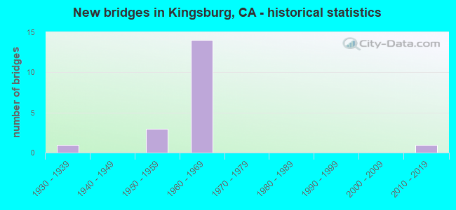
- New bridges - historical statistics
- 11930-1939
- 31950-1959
- 141960-1969
- 12010-2019
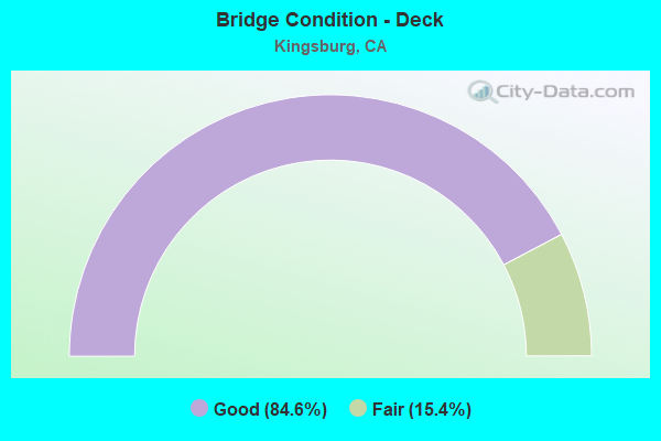
- Bridge Condition - Deck
- 84.6%Good
- 15.4%Fair
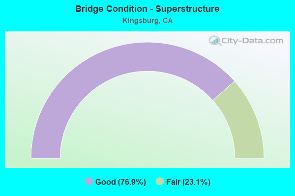
- Bridge Condition - Superstructure
- 76.9%Good
- 23.1%Fair
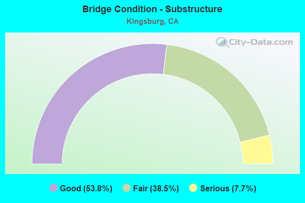
- Bridge Condition - Substructure
- 53.8%Good
- 38.5%Fair
- 7.7%Serious
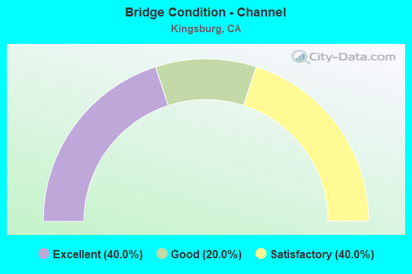
- Bridge Condition - Channel
- 40.0%Excellent
- 20.0%Good
- 40.0%Satisfactory
Find on map >> Show street view
Structure Number: 42 0219, Location: 06-FRE-099-R3.74 (Lat: 36.547000, Lng: -119.596686), Route carried "on" structure: Business County highway , Year Built: 1964, Status: Open, Structure Length: 8.11m (26.61ft), Average Daily Traffic: 3,200 (year 2009), Truck Traffic: 15%, Average Future Daily Traffic: 5,200 (year 2039), Design Load: HS 20+Mod, Features Intersected: STATE ROUTE 99, Facility Carried by Structure: MOUNTAIN VIEW AVE
Minimum Vertical Clearance: 30+ m (98+ ft), Kilometerpoint: 0.000, Lanes on structure: 2, Lanes under structure: 4, Base Highway Network: Yes, Owner: State Highway Agency, Approaching Roadway Width: 11.3m (37.1ft), Material/Design: Concrete continuous, Design/Construction: Box Beam or Girders - Multiple, Number Of Spans In Main Unit: 4, Length of Maximum Span: 24.6m (80.7ft), Curb or Sidewalk Widths: Left: 1.5m (4.9ft), Right: 0.0m, Curb-To-Curb Width: 9.8m (32.2ft), Out-to-Out Width: 12.0m (39.4ft)
Condition: Deck: Good, Superstructure: Good, Substructure: Good, Operating Rating: 33.0 metric tons, Method Used To Determine Operating Rating: Load and Resistance Factor Rating (LRFR) rating reported by rating factor(RF) method using HL-93 loadings, Inventory Rating: 25.3 metric tons, Method Used To Determine Inventory Rating: Load and Resistance Factor Rating (LRFR) rating reported by rating factor(RF) method using HL-93 loadings, Structural Evaluation: Equal to present minimum criteria, Deck Geometry: Meets minimum limits, Underclear: Somewhat better than minimum adequacy, Approach Roadway Alignment: Equal to present desirable criteria, Designated Inspection Frequency: Every 24 months, Inspection Date: April 2021, Deck Structure Type: Concrete Cast-file-Place, Wearing Surface/Protective System: Wearing Surface: Integral Concrete
Find on map >> Show street view
Structure Number: 42 0223, Location: 06-FRE-099-R2.06-KNGB (Lat: 36.528961, Lng: -119.575258), Route carried "on" structure: City street P043, Year Built: 1964, Status: Open, Structure Length: 9.33m (30.61ft), Average Daily Traffic: 1,950 (year 2017), Truck Traffic: 20%, Average Future Daily Traffic: 2,999 (year 2039), Design Load: HS 20+Mod, Features Intersected: STATE ROUTE 99, Facility Carried by Structure: BETHEL AVE
Minimum Vertical Clearance: 30+ m (98+ ft), Kilometerpoint: 0.000, Lanes on structure: 2, Lanes under structure: 4, Owner: State Highway Agency, Approaching Roadway Width: 12.2m (40.0ft), Material/Design: Concrete continuous, Design/Construction: Box Beam or Girders - Multiple, Number Of Spans In Main Unit: 4, Length of Maximum Span: 25.5m (83.7ft), Curb or Sidewalk Widths: Left: 1.5m (4.9ft), Right: 0.0m, Curb-To-Curb Width: 9.8m (32.2ft), Out-to-Out Width: 12.0m (39.4ft)
Condition: Deck: Good, Superstructure: Good, Substructure: Good, Operating Rating: 34.7 metric tons, Method Used To Determine Operating Rating: Load and Resistance Factor Rating (LRFR) rating reported by rating factor(RF) method using HL-93 loadings, Inventory Rating: 26.9 metric tons, Method Used To Determine Inventory Rating: Load and Resistance Factor Rating (LRFR) rating reported by rating factor(RF) method using HL-93 loadings, Structural Evaluation: Equal to present minimum criteria, Deck Geometry: Somewhat better than minimum adequacy, Underclear: Meets minimum limits, Approach Roadway Alignment: Equal to present desirable criteria, Designated Inspection Frequency: Every 24 months, Inspection Date: April 2021, Deck Structure Type: Concrete Cast-file-Place
Find on map >> Show street view
Structure Number: 42 0224, Location: 06-FRE-099-R0.46-KNGB (Lat: 36.512806, Lng: -119.555206), Route carried "on" structure: State highway 99, Year Built: 1964, Year Reconstructed: 2015, Status: Open, Structure Length: 4.42m (14.50ft), Average Daily Traffic: 48,000 (year 2009), Truck Traffic: 27%, Average Future Daily Traffic: 71,300 (year 2039), Features Intersected: DRAPER STREET
Minimum Vertical Clearance: 30+ m (98+ ft), Kilometerpoint: 0.460, Lanes on structure: 6, Lanes under structure: 2, Base Highway Network: Yes (, Subroute: 1), Owner: State Highway Agency, Approaching Roadway Width: 34.2m (112.2ft), Skew: 30 degrees, Material/Design: Concrete continuous, Design/Construction: Box Beam or Girders - Multiple, Number Of Spans In Main Unit: 3, Length of Maximum Span: 27.1m (88.9ft), Curb-To-Curb Width: 34.2m (112.2ft), Out-to-Out Width: 35.7m (117.1ft)
Condition: Deck: Good, Superstructure: Good, Substructure: Good, Operating Rating: 54.0 metric tons, Method Used To Determine Operating Rating: Field evaluation and documented engineering judgment, Inventory Rating: 32.4 metric tons, Method Used To Determine Inventory Rating: Field evaluation and documented engineering judgment, Structural Evaluation: Better than present minimum criteria, Deck Geometry: Superior to present desirable criteria, Underclear: Meets minimum limits, Approach Roadway Alignment: Equal to present desirable criteria, Designated Inspection Frequency: Every 24 months, Inspection Date: April 2021, Deck Structure Type: Concrete Cast-file-Place, Wearing Surface/Protective System: Wearing Surface: Integral Concrete
Find on map >> Show street view
Structure Number: 42 0225, Location: 06-FRE-099-R0.94-KNGB (Lat: 36.517753, Lng: -119.561178), Route carried "on" structure: State highway 99, Year Built: 1964, Year Reconstructed: 2015, Status: Open, Structure Length: 5.03m (16.50ft), Average Daily Traffic: 48,000 (year 2009), Truck Traffic: 27%, Average Future Daily Traffic: 71,300 (year 2039), Design Load: HS 20+Mod, Features Intersected: ST RTE 201 (SIERRA ST)
Minimum Vertical Clearance: 30+ m (98+ ft), Kilometerpoint: 0.940, Lanes on structure: 6, Lanes under structure: 5, Base Highway Network: Yes (, Subroute: 1), Owner: State Highway Agency, Approaching Roadway Width: 34.2m (112.2ft), Skew: 34 degrees, Material/Design: Concrete continuous, Design/Construction: Box Beam or Girders - Multiple, Number Of Spans In Main Unit: 3, Length of Maximum Span: 25.7m (84.3ft), Curb-To-Curb Width: 34.2m (112.2ft), Out-to-Out Width: 35.7m (117.1ft)
Condition: Deck: Good, Superstructure: Good, Substructure: Good, Operating Rating: 54.1 metric tons, Method Used To Determine Operating Rating: Assigned rating based on Load Factor Design (LFD) reported in metric tons, Inventory Rating: 32.4 metric tons, Method Used To Determine Inventory Rating: Assigned rating based on Load Factor Design (LFD) reported in metric tons, Structural Evaluation: Better than present minimum criteria, Deck Geometry: Superior to present desirable criteria, Underclear: Somewhat better than minimum adequacy, Approach Roadway Alignment: Equal to present desirable criteria, Designated Inspection Frequency: Every 24 months, Inspection Date: April 2021, Deck Structure Type: Concrete Cast-file-Place, Wearing Surface/Protective System: Wearing Surface: Integral Concrete
Find on map >> Show street view
Structure Number: 45C0007, Location: 0.2 MI S CLINTON AVE (Lat: 36.449364, Lng: -119.564517), Route carried "on" structure: County highway , Year Built: 1953, Status: Open, Structure Length: 3.78m (12.40ft), Average Daily Traffic: 1,664 (year 2017), Truck Traffic: 15%, Average Future Daily Traffic: 1,270 (year 2039), Design Load: H 20, Features Intersected: KINGS RIVER, Facility Carried by Structure: 6TH AVE
Minimum Vertical Clearance: 30+ m (98+ ft), Kilometerpoint: 0.000, Lanes on structure: 2, Owner: County Highway Agency, Approaching Roadway Width: 8.9m (29.2ft), Material/Design: Concrete continuous, Design/Construction: Slab, Number Of Spans In Main Unit: 6, Length of Maximum Span: 6.7m (22.0ft), Curb or Sidewalk Widths: Left: 0.3m (1.0ft), Right: 0.3m (1.0ft), Curb-To-Curb Width: 8.0m (26.2ft), Out-to-Out Width: 8.6m (28.2ft)
Condition: Deck: Good, Superstructure: Good, Substructure: Fair, Channel: Satisfactory, Operating Rating: 71.3 metric tons, Method Used To Determine Operating Rating: Load Factor (LF), Inventory Rating: 42.8 metric tons, Method Used To Determine Inventory Rating: Load Factor (LF), Structural Evaluation: Somewhat better than minimum adequacy, Deck Geometry: Meets minimum limits, Waterway Adequacy: Equal to present desirable criteria, Approach Roadway Alignment: Equal to present desirable criteria, Designated Inspection Frequency: Every 24 months, Inspection Date: November 2021, Deck Structure Type: Concrete Cast-file-Place, Wearing Surface/Protective System: Wearing Surface: Bituminous
Find on map >> Show street view
Structure Number: 45C0027, Location: 0.5 MI S OF BOSTON AVE (Lat: 36.484219, Lng: -119.557189), Route carried "on" structure: County highway , Year Built: 1962, Status: Open, Structure Length: 8.29m (27.20ft), Average Daily Traffic: 2,587 (year 2017), Truck Traffic: 15%, Average Future Daily Traffic: 2,130 (year 2039), Design Load: H 20, Features Intersected: COLE SLOUGH, Facility Carried by Structure: 5 1/2 AVE
Minimum Vertical Clearance: 30+ m (98+ ft), Kilometerpoint: 0.000, Lanes on structure: 2, Owner: County Highway Agency, Approaching Roadway Width: 8.9m (29.2ft), Material/Design: Concrete continuous, Design/Construction: Slab, Number Of Spans In Main Unit: 9, Length of Maximum Span: 9.1m (29.9ft), Curb-To-Curb Width: 9.8m (32.2ft), Out-to-Out Width: 10.0m (32.8ft)
Condition: Deck: Fair, Superstructure: Fair, Substructure: Serious, Channel: Satisfactory, Operating Rating: 58.3 metric tons, Method Used To Determine Operating Rating: Load Factor (LF), Inventory Rating: 35.0 metric tons, Method Used To Determine Inventory Rating: Load Factor (LF), Structural Evaluation: High priority of corrective action, Deck Geometry: Meets minimum limits, Waterway Adequacy: Better than present minimum criteria, Approach Roadway Alignment: Equal to present desirable criteria, Designated Inspection Frequency: Every 24 months, Inspection Date: November 2021, Deck Structure Type: Concrete Cast-file-Place
Find on map >> Show street view
Structure Number: 46 0084, Location: 06-TUL-201-R1.75 (Lat: 36.517806, Lng: -119.505786), Route carried "on" structure: State highway 201, Year Built: 1964, Status: Open, Structure Length: 9.88m (32.41ft), Average Daily Traffic: 5,400 (year 2009), Truck Traffic: 26%, Average Future Daily Traffic: 6,204 (year 2042), Design Load: HS 20, Features Intersected: KINGS RIVER
Minimum Vertical Clearance: 30+ m (98+ ft), Kilometerpoint: 1.750, Lanes on structure: 2, Owner: State Highway Agency, Approaching Roadway Width: 12.2m (40.0ft), Skew: 2 degrees, Material/Design: Concrete continuous, Design/Construction: Tee Beam, Number Of Spans In Main Unit: 7, Length of Maximum Span: 15.0m (49.2ft), Curb-To-Curb Width: 9.8m (32.2ft), Out-to-Out Width: 10.6m (34.8ft)
Condition: Deck: Good, Superstructure: Good, Substructure: Fair, Channel: Good, Operating Rating: 40.2 metric tons, Method Used To Determine Operating Rating: Load and Resistance Factor Rating (LRFR) rating reported by rating factor(RF) method using HL-93 loadings, Inventory Rating: 31.1 metric tons, Method Used To Determine Inventory Rating: Load and Resistance Factor Rating (LRFR) rating reported by rating factor(RF) method using HL-93 loadings, Structural Evaluation: Somewhat better than minimum adequacy, Deck Geometry: Meets minimum limits, Waterway Adequacy: Better than present minimum criteria, Approach Roadway Alignment: Equal to present desirable criteria, Designated Inspection Frequency: Every 24 months, Inspection Date: October 2020, Deck Structure Type: Concrete Cast-file-Place, Wearing Surface/Protective System: Wearing Surface: Bituminous, Membrane: Epoxy
Find on map >> Show street view
Structure Number: 46 0085, Location: 06-TUL-201-R1.87 (Lat: 36.517769, Lng: -119.503783), Route carried "on" structure: State highway 201, Year Built: 1964, Status: Open, Structure Length: 0.67m (2.20ft), Average Daily Traffic: 5,800 (year 2015), Truck Traffic: 26%, Average Future Daily Traffic: 6,500 (year 2040), Design Load: HS 20, Features Intersected: GOLF CART PATH
Minimum Vertical Clearance: 30+ m (98+ ft), Kilometerpoint: 1.870, Lanes on structure: 2, Owner: State Highway Agency, Approaching Roadway Width: 12.2m (40.0ft), Material/Design: Concrete, Design/Construction: Slab, Number Of Spans In Main Unit: 1, Length of Maximum Span: 6.7m (22.0ft), Curb or Sidewalk Widths: Left: 0.2m (0.7ft), Right: 0.2m (0.7ft), Curb-To-Curb Width: 12.2m (40.0ft), Out-to-Out Width: 12.8m (42.0ft)
Condition: Deck: Good, Superstructure: Good, Substructure: Fair, Operating Rating: 63.2 metric tons, Method Used To Determine Operating Rating: Load and Resistance Factor Rating (LRFR) rating reported by rating factor(RF) method using HL-93 loadings, Inventory Rating: 48.9 metric tons, Method Used To Determine Inventory Rating: Load and Resistance Factor Rating (LRFR) rating reported by rating factor(RF) method using HL-93 loadings, Structural Evaluation: Somewhat better than minimum adequacy, Deck Geometry: Somewhat better than minimum adequacy, Approach Roadway Alignment: Equal to present desirable criteria, Designated Inspection Frequency: Every 24 months, Inspection Date: June 2020, Deck Structure Type: Concrete Cast-file-Place, Wearing Surface/Protective System: Wearing Surface: Bituminous
Find on map >> Show street view
Structure Number: 46 0177, Location: 06-TUL-099-51.81 (Lat: 36.489781, Lng: -119.518708), Route carried "on" structure: County highway P201, Year Built: 1957, Status: Open, Structure Length: 5.88m (19.29ft), Average Daily Traffic: 2,500 (year 2011), Truck Traffic: 2%, Average Future Daily Traffic: 5,470 (year 2042), Design Load: HS 20, Features Intersected: STATE ROUTE 99, Facility Carried by Structure: DODGE AVE
Minimum Vertical Clearance: 30+ m (98+ ft), Kilometerpoint: 0.000, Lanes on structure: 2, Lanes under structure: 6, Owner: State Highway Agency, Approaching Roadway Width: 9.8m (32.2ft), Material/Design: Concrete continuous, Design/Construction: Box Beam or Girders - Multiple, Number Of Spans In Main Unit: 4, Length of Maximum Span: 18.3m (60.0ft), Curb or Sidewalk Widths: Left: 0.6m (2.0ft), Right: 1.5m (4.9ft), Curb-To-Curb Width: 8.5m (27.9ft), Out-to-Out Width: 11.3m (37.1ft)
Condition: Deck: Good, Superstructure: Good, Substructure: Fair, Operating Rating: 36.0 metric tons, Method Used To Determine Operating Rating: Load and Resistance Factor Rating (LRFR) rating reported by rating factor(RF) method using HL-93 loadings, Inventory Rating: 27.9 metric tons, Method Used To Determine Inventory Rating: Load and Resistance Factor Rating (LRFR) rating reported by rating factor(RF) method using HL-93 loadings, Structural Evaluation: Somewhat better than minimum adequacy, Deck Geometry: Meets minimum limits, Underclear: Somewhat better than minimum adequacy, Approach Roadway Alignment: Equal to present desirable criteria, Designated Inspection Frequency: Every 24 months, Inspection Date: October 2020, Deck Structure Type: Concrete Cast-file-Place
Find on map >> Show street view
Structure Number: 46 0199, Location: 06-TUL-099-R53.82 (Lat: 36.506383, Lng: -119.547947), Route carried "on" structure: County highway W203, Year Built: 1964, Status: Open, Structure Length: 9.20m (30.18ft), Average Daily Traffic: 5,000 (year 2011), Truck Traffic: 2%, Average Future Daily Traffic: 5,470 (year 2042), Design Load: HS 20+Mod, Features Intersected: STATE ROUTE 99, Facility Carried by Structure: MENDOCINO AV-RD 12
Minimum Vertical Clearance: 30+ m (98+ ft), Kilometerpoint: 0.000, Lanes on structure: 2, Lanes under structure: 6, Owner: State Highway Agency, Approaching Roadway Width: 12.2m (40.0ft), Material/Design: Concrete continuous, Design/Construction: Box Beam or Girders - Multiple, Number Of Spans In Main Unit: 4, Length of Maximum Span: 27.1m (88.9ft), Curb or Sidewalk Widths: Left: 1.6m (5.2ft), Right: 0.0m, Curb-To-Curb Width: 9.8m (32.2ft), Out-to-Out Width: 12.3m (40.4ft)
Condition: Deck: Good, Superstructure: Good, Substructure: Good, Operating Rating: 33.4 metric tons, Method Used To Determine Operating Rating: Load and Resistance Factor Rating (LRFR) rating reported by rating factor(RF) method using HL-93 loadings, Inventory Rating: 25.6 metric tons, Method Used To Determine Inventory Rating: Load and Resistance Factor Rating (LRFR) rating reported by rating factor(RF) method using HL-93 loadings, Structural Evaluation: Equal to present minimum criteria, Deck Geometry: Meets minimum limits, Underclear: Somewhat better than minimum adequacy, Approach Roadway Alignment: Equal to present minimum criteria, Designated Inspection Frequency: Every 24 months, Inspection Date: October 2020, Deck Structure Type: Concrete Cast-file-Place, Wearing Surface/Protective System: Wearing Surface: Bituminous
Find on map >> Show street view
Structure Number: 46 0267, Location: 06-TUL-099-52.60 (Lat: 36.496464, Lng: -119.530419), Route carried "on" structure: State highway 99, Year Built: 2014, Status: Open, Structure Length: 15.24m (50.00ft), Average Daily Traffic: 49,000 (year 2009), Truck Traffic: 35%, Average Future Daily Traffic: 69,017 (year 2042), Design Load: HL 93, Features Intersected: KINGS RIVER
Minimum Vertical Clearance: 30+ m (98+ ft), Kilometerpoint: 52.600, Lanes on structure: 4, Base Highway Network: Yes (, Subroute: 1), Owner: State Highway Agency, Approaching Roadway Width: 34.1m (111.9ft), Skew: 30 degrees, Material/Design: Prestressed concrete continuous, Design/Construction: Box Beam or Girders - Multiple, Number Of Spans In Main Unit: 4, Length of Maximum Span: 40.2m (131.9ft), Curb-To-Curb Width: 34.1m (111.9ft), Out-to-Out Width: 35.7m (117.1ft)
Condition: Deck: Good, Superstructure: Good, Substructure: Good, Channel: Excellent, Operating Rating: 42.1 metric tons, Method Used To Determine Operating Rating: Assigned ratings based on Load and Resistance Factor Design (LRFD) reported by rating factor (RF) using HL93 loadings, Inventory Rating: 32.4 metric tons, Method Used To Determine Inventory Rating: Assigned ratings based on Load and Resistance Factor Design (LRFD) reported by rating factor (RF) using HL93 loadings, Structural Evaluation: Better than present minimum criteria, Deck Geometry: Superior to present desirable criteria, Waterway Adequacy: Superior to present desirable criteria, Approach Roadway Alignment: Equal to present desirable criteria, Designated Inspection Frequency: Every 24 months, Inspection Date: October 2020, Deck Structure Type: Concrete Cast-file-Place
Find on map >> Show street view
Structure Number: 46C0064, Location: 600' N MENDOCINO AVE OC (Lat: 36.508022, Lng: -119.548119), Route carried "on" structure: County highway , Year Built: 1964, Status: Open, Structure Length: 7.62m (25.00ft), Average Daily Traffic: 5,000 (year 1984), Truck Traffic: 2%, Average Future Daily Traffic: 6,455 (year 2042), Design Load: HS 20, Features Intersected: MENDOCINO AVENUE OH, Facility Carried by Structure: MENDOCINO AVE
Minimum Vertical Clearance: 30+ m (98+ ft), Kilometerpoint: 0.000, Lanes on structure: 2, Owner: County Highway Agency, Approaching Roadway Width: 12.2m (40.0ft), Material/Design: Concrete continuous, Design/Construction: Box Beam or Girders - Multiple, Number Of Spans In Main Unit: 4, Length of Maximum Span: 25.3m (83.0ft), Curb or Sidewalk Widths: Left: 1.5m (4.9ft), Right: 0.0m, Curb-To-Curb Width: 9.8m (32.2ft), Out-to-Out Width: 12.3m (40.4ft)
Condition: Deck: Good, Superstructure: Fair, Substructure: Good, Operating Rating: 32.1 metric tons, Method Used To Determine Operating Rating: Load and Resistance Factor Rating (LRFR) rating reported by rating factor(RF) method using HL-93 loadings, Inventory Rating: 24.6 metric tons, Method Used To Determine Inventory Rating: Load and Resistance Factor Rating (LRFR) rating reported by rating factor(RF) method using HL-93 loadings, Structural Evaluation: Somewhat better than minimum adequacy, Deck Geometry: Meets minimum limits, Underclear: Somewhat better than minimum adequacy, Approach Roadway Alignment: Equal to present minimum criteria, Designated Inspection Frequency: Every 24 months, Inspection Date: December 2021, Deck Structure Type: Concrete Cast-file-Place, Wearing Surface/Protective System: Wearing Surface: Bituminous
Find on map >> Show street view
Structure Number: 46C0354, Location: ROAD 16 (Lat: 36.503319, Lng: -119.539014), Route carried "on" structure: County highway , Year Built: 1939, Status: Open, Structure Length: 0.81m (2.66ft), Average Daily Traffic: 75 (year 1978), Average Future Daily Traffic: 97 (year 2042), Features Intersected: KINGSBURG CANAL, Facility Carried by Structure: AVENUE 392
Minimum Vertical Clearance: 30+ m (98+ ft), Kilometerpoint: 0.000, Lanes on structure: 2, Owner: County Highway Agency, Approaching Roadway Width: 6.4m (21.0ft), Skew: 1 degrees, Material/Design: Concrete continuous, Design/Construction: Slab, Number Of Spans In Main Unit: 2, Length of Maximum Span: 3.9m (12.8ft), Curb or Sidewalk Widths: Left: 0.3m (1.0ft), Right: 0.3m (1.0ft), Curb-To-Curb Width: 6.4m (21.0ft), Out-to-Out Width: 7.2m (23.6ft)
Condition: Deck: Fair, Superstructure: Fair, Substructure: Fair, Channel: Excellent, Operating Rating: 22.0 metric tons, Method Used To Determine Operating Rating: Load Factor (LF), Inventory Rating: 13.3 metric tons, Method Used To Determine Inventory Rating: Load Factor (LF), Structural Evaluation: Meets minimum limits, Deck Geometry: Somewhat better than minimum adequacy, Waterway Adequacy: Equal to present desirable criteria, Approach Roadway Alignment: Equal to present minimum criteria, Designated Inspection Frequency: Every 24 months, Inspection Date: December 2021, Deck Structure Type: Concrete Cast-file-Place
Find on map >> Show street view
Structure Number: 42 0219, Location: 06-FRE-099-R3.74 (Lat: 36.547000, Lng: -119.596686), Route carried "under" structure: State highway 99, Year Built: 1964, Structure Length: 0. m, Average Daily Traffic: 51,000 (year 2009), Truck Traffic: 24%, Features Intersected: STATE ROUTE 99, Facility Carried by Structure: MOUNTAIN VIEW AVE
Minimum Vertical Clearance: 4.57m (14.99ft), Kilometerpoint: 3.740, Lanes on structure: 2, Lanes under structure: 4, Material/Design: Concrete continuous, Design/Construction: Box Beam or Girders - Multiple, Length of Maximum Span: 24.6m (80.7ft)
Find on map >> Show street view
Structure Number: 42 0223, Location: 06-FRE-099-R2.06-KNGB (Lat: 36.528961, Lng: -119.575258), Route carried "under" structure: State highway 99, Year Built: 1964, Structure Length: 0. m, Average Daily Traffic: 51,000 (year 2009), Truck Traffic: 24%, Features Intersected: STATE ROUTE 99, Facility Carried by Structure: BETHEL AVE
Minimum Vertical Clearance: 4.57m (14.99ft), Kilometerpoint: 2.060, Lanes on structure: 2, Lanes under structure: 4, Material/Design: Concrete continuous, Design/Construction: Box Beam or Girders - Multiple, Length of Maximum Span: 25.5m (83.7ft)
Find on map >> Show street view
Structure Number: 42 0224, Location: 06-FRE-099-R0.46-KNGB (Lat: 36.512806, Lng: -119.555206), Route carried "under" structure: City street , Year Built: 1964, Structure Length: 0. m, Average Daily Traffic: 6,820 (year 2017), Truck Traffic: 10%, Features Intersected: DRAPER STREET, Facility Carried by Structure: STATE ROUTE 99
Minimum Vertical Clearance: 4.67m (15.32ft), Kilometerpoint: 0.000, Lanes on structure: 6, Lanes under structure: 2, Material/Design: Concrete continuous, Design/Construction: Box Beam or Girders - Multiple, Length of Maximum Span: 27.1m (88.9ft)
Find on map >> Show street view
Structure Number: 42 0225, Location: 06-FRE-099-R0.94-KNGB (Lat: 36.517753, Lng: -119.561178), Route carried "under" structure: State highway 201, Year Built: 1964, Structure Length: 0. m, Average Daily Traffic: 17,600 (year 2009), Truck Traffic: 14%, Features Intersected: ST RTE 201 (SIERRA ST), Facility Carried by Structure: STATE ROUTE 99
Minimum Vertical Clearance: 4.54m (14.90ft), Kilometerpoint: 0.010, Lanes on structure: 6, Lanes under structure: 5, Material/Design: Concrete continuous, Design/Construction: Box Beam or Girders - Multiple, Length of Maximum Span: 25.7m (84.3ft)
Find on map >> Show street view
Structure Number: 46 0177, Location: 06-TUL-099-51.81 (Lat: 36.489781, Lng: -119.518708), Route carried "under" structure: State highway 99, Year Built: 1957, Structure Length: 0. m, Average Daily Traffic: 49,000 (year 2011), Truck Traffic: 35%, Features Intersected: STATE ROUTE 99, Facility Carried by Structure: DODGE AVE
Minimum Vertical Clearance: 4.67m (15.32ft), Kilometerpoint: 51.810, Lanes on structure: 2, Lanes under structure: 6, Material/Design: Concrete continuous, Design/Construction: Box Beam or Girders - Multiple, Length of Maximum Span: 18.3m (60.0ft)
Find on map >> Show street view
Structure Number: 46 0199, Location: 06-TUL-099-R53.82 (Lat: 36.506383, Lng: -119.547947), Route carried "under" structure: State highway 99, Year Built: 1964, Structure Length: 0. m, Average Daily Traffic: 49,000 (year 2009), Truck Traffic: 35%, Features Intersected: STATE ROUTE 99, Facility Carried by Structure: MENDOCINO AV-RD 12
Minimum Vertical Clearance: 5.84m (19.16ft), Kilometerpoint: 53.820, Lanes on structure: 2, Lanes under structure: 6, Material/Design: Concrete continuous, Design/Construction: Box Beam or Girders - Multiple, Length of Maximum Span: 27.1m (88.9ft)