Bridge Statistics for Kinde, Michigan (MI)
Condition, Traffic, Stress, Structural Evaluation, Project Costs
- National Bridge Inventory (NBI) Statistics
- 18Number of bridges
- 141ft / 43.3mTotal length
- $37,000Total costs
- 229,898Total average daily traffic
- 17,792Total average daily truck traffic
- National Bridge Inventory (NBI) Registered Bridges for Kinde
- No street view available for this location
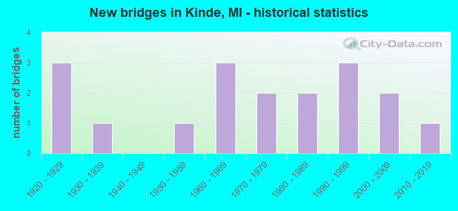
- New bridges - historical statistics
- 31920-1929
- 11930-1939
- 11950-1959
- 31960-1969
- 21970-1979
- 21980-1989
- 31990-1999
- 22000-2009
- 12010-2019

- Reconstructed bridges - Historical Statistics
- 21980-1989
- 11990-1999
- 12000-2009


- Bridge Condition - Deck
- 13.3%Very good
- 46.7%Good
- 26.7%Satisfactory
- 6.7%Fair
- 6.7%Poor

- Bridge Condition - Superstructure
- 20.0%Very good
- 26.7%Good
- 20.0%Satisfactory
- 20.0%Fair
- 13.3%Poor

- Bridge Condition - Substructure
- 13.3%Very good
- 40.0%Good
- 26.7%Satisfactory
- 20.0%Poor

- Bridge Condition - Channel
- 7.7%Very good
- 53.8%Good
- 23.1%Satisfactory
- 15.4%Fair
Find on map >> Show street view
Structure Number: 1333, Location: MARENGO TWP SEC 14 (Lat: 42.297008, Lng: -84.862714), Route carried "on" structure: County highway 1373, Year Built: 1959, Status: Open, Structure Length: 1.52m (4.99ft), Average Daily Traffic: 717 (year 1995), Truck Traffic: 12%, Average Future Daily Traffic: 1,283 (year 2023), Design Load: H 15, Features Intersected: RICE CREEK, Facility Carried by Structure: 22 1/2 MI ROAD
Minimum Vertical Clearance: 30.48m (100.00ft), Kilometerpoint: 2.448, Lanes on structure: 2, Owner: County Highway Agency, Approaching Roadway Width: 8.8m (28.9ft), Material/Design: Prestressed concrete, Design/Construction: Box Beam or Girders - Multiple, Number Of Spans In Main Unit: 1, Length of Maximum Span: 15.2m (49.9ft), Curb or Sidewalk Widths: Left: 0.6m (2.0ft), Right: 0.6m (2.0ft), Curb-To-Curb Width: 8.2m (26.9ft), Out-to-Out Width: 9.8m (32.2ft)
Condition: Deck: Satisfactory, Superstructure: Fair, Substructure: Good, Channel: Good, Operating Rating: 57.2 metric tons, Method Used To Determine Operating Rating: Load Factor (LF), Inventory Rating: 28.4 metric tons, Method Used To Determine Inventory Rating: Load Factor (LF), Structural Evaluation: Somewhat better than minimum adequacy, Deck Geometry: Somewhat better than minimum adequacy, Waterway Adequacy: Equal to present desirable criteria, Approach Roadway Alignment: Equal to present desirable criteria, Designated Inspection Frequency: Every 24 months, Inspection Date: September 2021, Deck Structure Type: Concrete Precast Panels, Wearing Surface/Protective System: Wearing Surface: Bituminous
Find on map >> Show street view
Structure Number: 1665, Location: 3.5 MI E BRIMLEY (Lat: 46.396964, Lng: -84.533069), Route carried "on" structure: County highway , Year Built: 1990, Status: Open, Structure Length: 4.57m (14.99ft), Average Daily Traffic: 21 (year 2005), Average Future Daily Traffic: 35 (year 2019), Design Load: HS 20, Features Intersected: WAISKA RIVER, Facility Carried by Structure: TONE ROAD
Minimum Vertical Clearance: 30.48m (100.00ft), Kilometerpoint: 3.248, Lanes on structure: 2, Owner: County Highway Agency, Approaching Roadway Width: 11.0m (36.1ft), Skew: 4 degrees, Material/Design: Prestressed concrete, Design/Construction: Box Beam or Girders - Multiple, Number Of Spans In Main Unit: 2, Length of Maximum Span: 22.2m (72.8ft), Curb-To-Curb Width: 8.5m (27.9ft), Out-to-Out Width: 9.1m (29.9ft)
Condition: Deck: Satisfactory, Superstructure: Satisfactory, Substructure: Good, Channel: Good, Operating Rating: 62.5 metric tons, Method Used To Determine Operating Rating: Load Factor (LF) rating reported by rating factor (RF) method using MS18 loading, Inventory Rating: 37.3 metric tons, Method Used To Determine Inventory Rating: Load Factor (LF) rating reported by rating factor (RF) method using MS18 loading, Structural Evaluation: Equal to present minimum criteria, Deck Geometry: Better than present minimum criteria, Waterway Adequacy: Equal to present desirable criteria, Approach Roadway Alignment: Equal to present desirable criteria, Designated Inspection Frequency: Every 24 months, Underwater Inspection Frequency: Every 60 months, Inspection Date: June 2021, Underwater Inspection Date: July 2018, Deck Structure Type: Corrugated Steel, Wearing Surface/Protective System: Wearing Surface: Bituminous, Membrane: Built-up
Find on map >> Show street view
Structure Number: 2032, Location: 0.5 MI S OF M-72 (Lat: 44.652133, Lng: -84.703497), Route carried "on" structure: Interstate 75, Year Built: 1961, Status: Open, Structure Length: 4.36m (14.30ft), Average Daily Traffic: 5,877 (year 2007), Truck Traffic: 12%, Average Future Daily Traffic: 10,388 (year 2018), Design Load: HS 20+Mod, Features Intersected: LAKE STATE RR
Minimum Vertical Clearance: 30.48m (100.00ft), Kilometerpoint: 16.973, Lanes on structure: 2, Base Highway Network: Yes (Inventory Route: 53, Subroute: 1), Owner: State Highway Agency, Approaching Roadway Width: 14.6m (47.9ft), Skew: 1 degrees, Material/Design: Steel, Design/Construction: Stringer/Multi-beam, Number Of Spans In Main Unit: 3, Length of Maximum Span: 14.6m (47.9ft), Curb-To-Curb Width: 13.1m (43.0ft), Out-to-Out Width: 14.3m (46.9ft)
Condition: Deck: Satisfactory, Superstructure: Fair, Substructure: Poor, Operating Rating: 56.4 metric tons, Method Used To Determine Operating Rating: Load Factor (LF) rating reported by rating factor (RF) method using MS18 loading, Inventory Rating: 33.7 metric tons, Method Used To Determine Inventory Rating: Load Factor (LF) rating reported by rating factor (RF) method using MS18 loading, Structural Evaluation: Meets minimum limits, Deck Geometry: Superior to present desirable criteria, Approach Roadway Alignment: Equal to present minimum criteria, Designated Inspection Frequency: Every 12 months, Inspection Date: September 2021, Deck Structure Type: Concrete Cast-file-Place, Wearing Surface/Protective System: Wearing Surface: Latex Concrete
Find on map >> Show street view
Structure Number: 3529, Location: SEC. 34 HUME TWP. (Lat: 43.937039, Lng: -83.062786), Route carried "on" structure: County highway 3266, Year Built: 1921, Year Reconstructed: 1996, Status: Open, Structure Length: 0.79m (2.59ft), Average Daily Traffic: 1,500 (year 2009), Average Future Daily Traffic: 2,700 (year 2029), Design Load: HS 20, Features Intersected: MOORE CREEK, Facility Carried by Structure: KINDE ROAD
Minimum Vertical Clearance: 30.48m (100.00ft), Kilometerpoint: 14.885, Lanes on structure: 2, Owner: County Highway Agency, Approaching Roadway Width: 10.4m (34.1ft), Material/Design: Prestressed concrete, Design/Construction: Tee Beam, Number Of Spans In Main Unit: 1, Length of Maximum Span: 7.5m (24.6ft), Curb-To-Curb Width: 10.2m (33.5ft), Out-to-Out Width: 11.1m (36.4ft)
Condition: Deck: Good, Superstructure: Satisfactory, Substructure: Satisfactory, Channel: Good, Operating Rating: 79.4 metric tons, Method Used To Determine Operating Rating: Load Factor (LF), Inventory Rating: 47.6 metric tons, Method Used To Determine Inventory Rating: Load Factor (LF), Structural Evaluation: Equal to present minimum criteria, Deck Geometry: Somewhat better than minimum adequacy, Waterway Adequacy: Better than present minimum criteria, Approach Roadway Alignment: Equal to present desirable criteria, Designated Inspection Frequency: Every 24 months, Inspection Date: August 2021, Deck Structure Type: Concrete Precast Panels, Wearing Surface/Protective System: Wearing Surface: Bituminous
Find on map >> Show street view
Structure Number: 361, Location: SEC 33-34 HUME TWP (Lat: 43.937678, Lng: -83.064833), Route carried "on" structure: ServiceCounty highway , Year Built: 1920, Year Reconstructed: 1987, Status: Open, Structure Length: 0.70m (2.30ft), Average Daily Traffic: 180 (year 2009), Truck Traffic: 1%, Average Future Daily Traffic: 325 (year 2029), Design Load: HS 20, Features Intersected: MOORE CREEK, Facility Carried by Structure: MCMILLAN ROAD
Minimum Vertical Clearance: 30.48m (100.00ft), Kilometerpoint: 0.077, Lanes on structure: 2, Owner: County Highway Agency, Approaching Roadway Width: 9.1m (29.9ft), Material/Design: Prestressed concrete, Design/Construction: Tee Beam, Number Of Spans In Main Unit: 1, Length of Maximum Span: 6.4m (21.0ft), Curb-To-Curb Width: 8.4m (27.6ft), Out-to-Out Width: 8.6m (28.2ft)
Condition: Deck: Good, Superstructure: Poor, Substructure: Satisfactory, Channel: Fair, Operating Rating: 26.9 metric tons, Method Used To Determine Operating Rating: Load and Resistance Factor Rating (LRFR) rating reported by rating factor(RF) method using HL-93 loadings, Inventory Rating: 20.7 metric tons, Method Used To Determine Inventory Rating: Load and Resistance Factor Rating (LRFR) rating reported by rating factor(RF) method using HL-93 loadings, Structural Evaluation: Meets minimum limits, Deck Geometry: Somewhat better than minimum adequacy, Waterway Adequacy: Better than present minimum criteria, Approach Roadway Alignment: Equal to present minimum criteria, Designated Inspection Frequency: Every 12 months, Inspection Date: August 2021, Deck Structure Type: Concrete Precast Panels, Wearing Surface/Protective System: Wearing Surface: Bituminous
Find on map >> Show street view
Structure Number: 3759, Location: IN EAST LANSING (Lat: 42.719261, Lng: -84.504311), Route carried "on" structure: Interstate 496, Year Built: 1963, Status: Temporarily open, Structure Length: 5.82m (19.09ft), Average Daily Traffic: 34,668 (year 2015), Truck Traffic: 7%, Average Future Daily Traffic: 34,953 (year 2018), Design Load: HS 20+Mod, Features Intersected: GTW RR
Minimum Vertical Clearance: 30.48m (100.00ft), Kilometerpoint: 8.502, Lanes on structure: 3, Base Highway Network: Yes (Inventory Route: 35, Subroute: 10), Owner: State Highway Agency, Approaching Roadway Width: 15.5m (50.9ft), Material/Design: Steel, Design/Construction: Stringer/Multi-beam, Number Of Spans In Main Unit: 3, Length of Maximum Span: 25.3m (83.0ft), Curb or Sidewalk Widths: Left: 0.0m, Right: 0.2m (0.7ft), Curb-To-Curb Width: 14.0m (45.9ft), Out-to-Out Width: 14.7m (48.2ft)
Condition: Deck: Satisfactory, Superstructure: Fair, Substructure: Poor, Structural Evaluation: High priority of replacement, Deck Geometry: Meets minimum limits, Approach Roadway Alignment: Equal to present desirable criteria, Designated Inspection Frequency: Every 24 months, Inspection Date: October 2021, Bridge Improvement Cost: $1,222,000, Deck Structure Type: Concrete Cast-file-Place, Wearing Surface/Protective System: Wearing Surface: Latex Concrete
Find on map >> Show street view
Structure Number: 8006, Location: @ I-75 , M-24 (Lat: 42.683569, Lng: -83.243297), Route carried "on" structure: Interstate 75, Year Built: 1962, Year Reconstructed: 1988, Status: Open, Structure Length: 5.91m (19.39ft), Average Daily Traffic: 71,900 (year 2009), Truck Traffic: 4%, Average Future Daily Traffic: 80,300 (year 2029), Design Load: HS 20+Mod, Features Intersected: I-75 BL & M-24
Minimum Vertical Clearance: 30.48m (100.00ft), Kilometerpoint: 34.572, Lanes on structure: 4, Lanes under structure: 6, Base Highway Network: Yes (Inventory Route: 64, Subroute: 8), Owner: State Highway Agency, Approaching Roadway Width: 18.0m (59.1ft), Skew: 11 degrees, Material/Design: Prestressed concrete, Design/Construction: Stringer/Multi-beam, Number Of Spans In Main Unit: 4, Length of Maximum Span: 18.6m (61.0ft), Curb-To-Curb Width: 20.5m (67.3ft), Out-to-Out Width: 21.7m (71.2ft)
Condition: Deck: Good, Superstructure: Good, Substructure: Good, Operating Rating: 61.6 metric tons, Method Used To Determine Operating Rating: Load Factor (LF) rating reported by rating factor (RF) method using MS18 loading, Inventory Rating: 36.9 metric tons, Method Used To Determine Inventory Rating: Load Factor (LF) rating reported by rating factor (RF) method using MS18 loading, Structural Evaluation: Better than present minimum criteria, Deck Geometry: Equal to present minimum criteria, Underclear: High priority of corrective action, Approach Roadway Alignment: Equal to present desirable criteria, Designated Inspection Frequency: Every 24 months, Inspection Date: December 2021, Deck Structure Type: Concrete Cast-file-Place, Wearing Surface/Protective System: Wearing Surface: Latex Concrete, Deck Protection: Epoxy Coated Reinforcing
Find on map >> Show street view
Structure Number: 8451, Location: 3 MI E OF M-33 (Lat: 44.313061, Lng: -84.069836), Route carried "on" structure: County highway , Year Built: 1987, Status: Open, Structure Length: 2.28m (7.48ft), Average Daily Traffic: 1,072 (year 2006), Average Future Daily Traffic: 1,300 (year 2026), Design Load: HS 20, Features Intersected: RIFLE RIVER, Facility Carried by Structure: STATE ROAD
Minimum Vertical Clearance: 30.48m (100.00ft), Kilometerpoint: 14.182, Lanes on structure: 2, Owner: County Highway Agency, Approaching Roadway Width: 9.1m (29.9ft), Material/Design: Prestressed concrete, Design/Construction: Box Beam or Girders - Multiple, Number Of Spans In Main Unit: 1, Length of Maximum Span: 21.6m (70.9ft), Curb-To-Curb Width: 12.2m (40.0ft), Out-to-Out Width: 12.3m (40.4ft)
Condition: Deck: Very good, Superstructure: Very good, Substructure: Very good, Channel: Good, Operating Rating: 74.1 metric tons, Method Used To Determine Operating Rating: Load Factor (LF), Inventory Rating: 44.1 metric tons, Method Used To Determine Inventory Rating: Load Factor (LF), Structural Evaluation: Equal to present desirable criteria, Deck Geometry: Better than present minimum criteria, Waterway Adequacy: Equal to present desirable criteria, Approach Roadway Alignment: Equal to present desirable criteria, Designated Inspection Frequency: Every 24 months, Inspection Date: July 2021, Deck Structure Type: Concrete Precast Panels, Wearing Surface/Protective System: Wearing Surface: Bituminous, Membrane: Preformed Fabric, Deck Protection: Epoxy Coated Reinforcing
Find on map >> Show street view
Structure Number: 12182, Location: DETROIT S/I-96 (Lat: 42.383533, Lng: -83.259158), Route carried "on" structure: County highway 2000, Year Built: 1927, Status: Open, Structure Length: 2.93m (9.61ft), Average Daily Traffic: 14,610 (year 2013), Truck Traffic: 9%, Average Future Daily Traffic: 14,640 (year 2033), Design Load: HS 20+Mod, Features Intersected: UPPER ROUGE RIVER, Facility Carried by Structure: OUTER DRIVE
Minimum Vertical Clearance: 30.48m (100.00ft), Kilometerpoint: 7.791, Lanes on structure: 4, Owner: County Highway Agency, Approaching Roadway Width: 18.3m (60.0ft), Material/Design: Concrete, Design/Construction: Tee Beam, Number Of Spans In Main Unit: 2, Length of Maximum Span: 14.0m (45.9ft), Curb or Sidewalk Widths: Left: 2.7m (8.9ft), Right: 2.7m (8.9ft), Curb-To-Curb Width: 18.3m (60.0ft), Out-to-Out Width: 25.0m (82.0ft)
Condition: Deck: Poor, Superstructure: Poor, Substructure: Poor, Channel: Satisfactory, Operating Rating: 85.2 metric tons, Method Used To Determine Operating Rating: Load Factor (LF) rating reported by rating factor (RF) method using MS18 loading, Inventory Rating: 51.2 metric tons, Method Used To Determine Inventory Rating: Load Factor (LF) rating reported by rating factor (RF) method using MS18 loading, Structural Evaluation: Meets minimum limits, Deck Geometry: Somewhat better than minimum adequacy, Waterway Adequacy: Equal to present desirable criteria, Approach Roadway Alignment: Equal to present desirable criteria, Designated Inspection Frequency: Every 12 months, Inspection Date: June 2021, Deck Structure Type: Concrete Cast-file-Place, Wearing Surface/Protective System: Wearing Surface: Epoxy Overlay
Find on map >> Show street view
Structure Number: 12271, Location: GROSSE ILE E/MERIDIAN (Lat: 42.163089, Lng: -83.148111), Route carried "on" structure: County highway , Year Built: 1937, Year Reconstructed: 2000, Status: Open, Structure Length: 2.50m (8.20ft), Average Daily Traffic: 1,338 (year 2001), Truck Traffic: 1%, Average Future Daily Traffic: 1,520 (year 2015), Design Load: HS 20, Features Intersected: THOROFARE CANAL, Facility Carried by Structure: HORSE MILL ROAD
Minimum Vertical Clearance: 30.48m (100.00ft), Kilometerpoint: 1.022, Lanes on structure: 2, Owner: County Highway Agency, Approaching Roadway Width: 10.7m (35.1ft), Skew: 1 degrees, Material/Design: Prestressed concrete, Design/Construction: Box Beam or Girders - Multiple, Number Of Spans In Main Unit: 1, Length of Maximum Span: 23.8m (78.1ft), Curb or Sidewalk Widths: Left: 2.4m (7.9ft), Right: 2.4m (7.9ft), Curb-To-Curb Width: 10.7m (35.1ft), Out-to-Out Width: 14.0m (45.9ft)
Condition: Deck: Good, Superstructure: Very good, Substructure: Satisfactory, Channel: Good, Operating Rating: 97.2 metric tons, Method Used To Determine Operating Rating: Load Factor (LF) rating reported by rating factor (RF) method using MS18 loading, Inventory Rating: 51.2 metric tons, Method Used To Determine Inventory Rating: Load Factor (LF) rating reported by rating factor (RF) method using MS18 loading, Structural Evaluation: Equal to present minimum criteria, Deck Geometry: Equal to present minimum criteria, Waterway Adequacy: Superior to present desirable criteria, Approach Roadway Alignment: Equal to present desirable criteria, Designated Inspection Frequency: Every 24 months, Inspection Date: October 2020, Deck Structure Type: Concrete Cast-file-Place, Wearing Surface/Protective System: Wearing Surface: Integral Concrete, Deck Protection: Epoxy Coated Reinforcing
Find on map >> Show street view
Structure Number: 12327, Location: IN DEARBORN HEIGHTS (Lat: 42.271978, Lng: -83.255972), Route carried "on" structure: City street , Year Built: 1989, Status: Open, Structure Length: 0.79m (2.59ft), Average Daily Traffic: 6,000 (year 1989), Truck Traffic: 5%, Average Future Daily Traffic: 6,000 (year 2010), Design Load: HS 20+Mod, Features Intersected: ECORSE CREEK, Facility Carried by Structure: PARDEE ROAD
Minimum Vertical Clearance: 30.48m (100.00ft), Kilometerpoint: 0.301, Lanes on structure: 2, Owner: City or Municipal Highway Agency, Approaching Roadway Width: 7.9m (25.9ft), Material/Design: Prestressed concrete, Design/Construction: Box Beam or Girders - Multiple, Number Of Spans In Main Unit: 1, Length of Maximum Span: 6.7m (22.0ft), Curb or Sidewalk Widths: Left: 1.8m (5.9ft), Right: 1.8m (5.9ft), Curb-To-Curb Width: 8.2m (26.9ft), Out-to-Out Width: 12.5m (41.0ft)
Condition: Deck: Good, Superstructure: Good, Substructure: Good, Channel: Satisfactory, Operating Rating: 97.2 metric tons, Method Used To Determine Operating Rating: Load Factor (LF) rating reported by rating factor (RF) method using MS18 loading, Inventory Rating: 62.2 metric tons, Method Used To Determine Inventory Rating: Load Factor (LF) rating reported by rating factor (RF) method using MS18 loading, Structural Evaluation: Better than present minimum criteria, Deck Geometry: High priority of replacement, Waterway Adequacy: Equal to present desirable criteria, Approach Roadway Alignment: Equal to present desirable criteria, Designated Inspection Frequency: Every 24 months, Inspection Date: October 2021, Deck Structure Type: Concrete Cast-file-Place, Wearing Surface/Protective System: Wearing Surface: Integral Concrete, Deck Protection: Epoxy Coated Reinforcing
Find on map >> Show street view
Structure Number: 12506, Location: IN LINCOLN PARK (Lat: 42.224086, Lng: -83.197456), Route carried "on" structure: City street , Year Built: 2016, Status: Open, Structure Length: 1.28m (4.20ft), Average Daily Traffic: 300 (year 2015), Average Future Daily Traffic: 400 (year 2035), Design Load: Greater than HL93, Features Intersected: SEXTON KILFOIL DRAIN, Facility Carried by Structure: HAZEL STREET
Minimum Vertical Clearance: 30.48m (100.00ft), Kilometerpoint: 0.348, Lanes on structure: 2, Owner: City or Municipal Highway Agency, Approaching Roadway Width: 8.5m (27.9ft), Material/Design: Prestressed concrete, Design/Construction: Box Beam or Girders - Single/Spread, Number Of Spans In Main Unit: 1, Length of Maximum Span: 11.9m (39.0ft), Curb or Sidewalk Widths: Left: 1.6m (5.2ft), Right: 1.6m (5.2ft), Curb-To-Curb Width: 8.5m (27.9ft), Out-to-Out Width: 12.4m (40.7ft)
Condition: Deck: Very good, Superstructure: Very good, Substructure: Very good, Channel: Good, Operating Rating: 62.9 metric tons, Method Used To Determine Operating Rating: Load and Resistance Factor Rating (LRFR) rating reported by rating factor(RF) method using HL-93 loadings, Inventory Rating: 48.3 metric tons, Method Used To Determine Inventory Rating: Load and Resistance Factor Rating (LRFR) rating reported by rating factor(RF) method using HL-93 loadings, Structural Evaluation: Equal to present desirable criteria, Deck Geometry: Equal to present minimum criteria, Waterway Adequacy: Equal to present minimum criteria, Approach Roadway Alignment: Better than present minimum criteria, Length Of Structure Improvement: 1.19m (3.90ft), Designated Inspection Frequency: Every 24 months, Inspection Date: August 2021, Deck Structure Type: Concrete Cast-file-Place, Wearing Surface/Protective System: Wearing Surface: Monolithic Concrete, Deck Protection: Epoxy Coated Reinforcing
Find on map >> Show street view
Structure Number: 12519, Location: IN CITY OF WAYNE (Lat: 42.284747, Lng: -83.381181), Route carried "on" structure: City street , Year Built: 1976, Status: Open, Structure Length: 1.82m (5.97ft), Average Daily Traffic: 2,457 (year 2015), Truck Traffic: 3%, Average Future Daily Traffic: 3,182 (year 2040), Design Load: HS 20+Mod, Features Intersected: LOWER ROUGE RIVER, Facility Carried by Structure: SECOND AVE
Minimum Vertical Clearance: 30.48m (100.00ft), Kilometerpoint: 1.201, Lanes on structure: 2, Owner: City or Municipal Highway Agency, Approaching Roadway Width: 10.9m (35.8ft), Material/Design: Prestressed concrete, Design/Construction: Box Beam or Girders - Multiple, Number Of Spans In Main Unit: 1, Length of Maximum Span: 17.0m (55.8ft), Curb or Sidewalk Widths: Left: 2.8m (9.2ft), Right: 2.8m (9.2ft), Curb-To-Curb Width: 12.2m (40.0ft), Out-to-Out Width: 18.5m (60.7ft)
Condition: Deck: Fair, Superstructure: Satisfactory, Substructure: Satisfactory, Channel: Satisfactory, Operating Rating: 62.7 metric tons, Method Used To Determine Operating Rating: Load Factor (LF), Inventory Rating: 37.6 metric tons, Method Used To Determine Inventory Rating: Load Factor (LF), Structural Evaluation: Equal to present minimum criteria, Deck Geometry: Equal to present minimum criteria, Waterway Adequacy: Better than present minimum criteria, Approach Roadway Alignment: Equal to present desirable criteria, Designated Inspection Frequency: Every 24 months, Inspection Date: April 2020, Deck Structure Type: Concrete Precast Panels, Wearing Surface/Protective System: Wearing Surface: Latex Concrete
Find on map >> Show street view
Structure Number: 13043, Location: SEC 21/22, T22N, R7W (Lat: 44.288953, Lng: -85.175164), Route carried "on" structure: County highway , Year Built: 2000, Status: Open, Structure Length: 0.79m (2.59ft), Average Daily Traffic: 112 (year 2007), Average Future Daily Traffic: 200 (year 2027), Design Load: HS 20, Features Intersected: MOSQUITO CREEK, Facility Carried by Structure: MCGEE ROAD
Minimum Vertical Clearance: 30.48m (100.00ft), Kilometerpoint: 0.921, Lanes on structure: 2, Owner: County Highway Agency, Approaching Roadway Width: 4.9m (16.1ft), Skew: 2 degrees, Material/Design: Wood or Timber, Design/Construction: Slab, Number Of Spans In Main Unit: 1, Length of Maximum Span: 7.6m (24.9ft), Curb-To-Curb Width: 7.9m (25.9ft), Out-to-Out Width: 8.5m (27.9ft)
Condition: Deck: Good, Superstructure: Good, Substructure: Good, Channel: Good, Operating Rating: 53.8 metric tons, Method Used To Determine Operating Rating: Allowable Stress (AS) rating reported by rating factor (RF) method using MS18 loading, Inventory Rating: 38.6 metric tons, Method Used To Determine Inventory Rating: Allowable Stress (AS) rating reported by rating factor (RF) method using MS18 loading, Structural Evaluation: Better than present minimum criteria, Deck Geometry: Somewhat better than minimum adequacy, Waterway Adequacy: Better than present minimum criteria, Approach Roadway Alignment: Better than present minimum criteria, Designated Inspection Frequency: Every 24 months, Inspection Date: May 2021, Deck Structure Type: Wood or Timber, Wearing Surface/Protective System: Wearing Surface: Wood or Timber, Deck Protection: Epoxy Coated Reinforcing
Find on map >> Show street view
Structure Number: 13439, Location: IN BLOOMFIELD HILLS (Lat: 42.584944, Lng: -83.236861), Route carried "on" structure: City street , Year Built: 1975, Status: Open, Structure Length: 1.15m (3.77ft), Average Daily Traffic: 3,000 (year 2008), Truck Traffic: 2%, Average Future Daily Traffic: 3,400 (year 2015), Design Load: HS 20, Features Intersected: ROUGE RIVER TRIB /N CULV, Facility Carried by Structure: BLMFLD HILLS PKWY
Minimum Vertical Clearance: 30.48m (100.00ft), Kilometerpoint: 0.895, Lanes on structure: 2, Owner: City or Municipal Highway Agency, Approaching Roadway Width: 15.2m (49.9ft), Skew: 4 degrees, Material/Design: Concrete, Design/Construction: Culvert, Number Of Spans In Main Unit: 3, Length of Maximum Span: 3.0m (9.8ft), Curb or Sidewalk Widths: Left: 0.5m (1.6ft), Right: 0.5m (1.6ft), Curb-To-Curb Width: 15.2m (49.9ft), Out-to-Out Width: 30.2m (99.1ft)
Condition: Channel: Fair, Culverts: Good, Operating Rating: 54.1 metric tons, Method Used To Determine Operating Rating: Load Factor (LF) rating reported by rating factor (RF) method using MS18 loading, Inventory Rating: 32.4 metric tons, Method Used To Determine Inventory Rating: Load Factor (LF) rating reported by rating factor (RF) method using MS18 loading, Structural Evaluation: Better than present minimum criteria, Deck Geometry: Superior to present desirable criteria, Waterway Adequacy: Equal to present desirable criteria, Approach Roadway Alignment: Equal to present minimum criteria, Length Of Structure Improvement: 6.10m (20.01ft), Designated Inspection Frequency: Every 24 months, Inspection Date: January 2022, Bridge Improvement Cost: $19,000, Roadway Improvement Cost: $1,000, Total Project Cost: $37,000
Find on map >> Show street view
Structure Number: 13442, Location: IN ROCKWOOD (Lat: 42.067928, Lng: -83.254133), Route carried "on" structure: Interstate 75, Year Built: 2009, Status: Open, Structure Length: 6.10m (20.01ft), Average Daily Traffic: 31,814 (year 2003), Truck Traffic: 21%, Average Future Daily Traffic: 40,250 (year 2028), Design Load: HL 93, Features Intersected: HURON RIVER
Minimum Vertical Clearance: 30+ m (98+ ft), Kilometerpoint: 43.059, Lanes on structure: 4, Base Highway Network: Yes (Inventory Route: 122, Subroute: 9), Owner: State Highway Agency, Approaching Roadway Width: 21.3m (69.9ft), Skew: 1 degrees, Material/Design: Steel continuous, Design/Construction: Stringer/Multi-beam, Number Of Spans In Main Unit: 3, Length of Maximum Span: 27.4m (89.9ft), Curb-To-Curb Width: 21.3m (69.9ft), Out-to-Out Width: 22.3m (73.2ft)
Condition: Deck: Good, Superstructure: Good, Substructure: Good, Channel: Very good, Operating Rating: 77.1 metric tons, Method Used To Determine Operating Rating: Load and Resistance Factor Rating (LRFR) rating reported by rating factor(RF) method using HL-93 loadings, Inventory Rating: 59.6 metric tons, Method Used To Determine Inventory Rating: Load and Resistance Factor Rating (LRFR) rating reported by rating factor(RF) method using HL-93 loadings, Structural Evaluation: Better than present minimum criteria, Deck Geometry: Better than present minimum criteria, Waterway Adequacy: Equal to present minimum criteria, Approach Roadway Alignment: Equal to present desirable criteria, Designated Inspection Frequency: Every 24 months, Inspection Date: August 2021, Deck Structure Type: Concrete Cast-file-Place, Wearing Surface/Protective System: Wearing Surface: Monolithic Concrete, Deck Protection: Epoxy Coated Reinforcing
Find on map >> Show street view
Structure Number: 12766, Location: CITY OF PONTIAC (Lat: 42.638061, Lng: -83.296839), Route carried "under" structure: State highway 59, Year Built: 1998, Structure Length: 0. m, Average Daily Traffic: 27,166 (year 2007), Truck Traffic: 6%, Features Intersected: M-59, Facility Carried by Structure: GTWRR(EAST TRACK)
Minimum Vertical Clearance: 4.57m (14.99ft), Kilometerpoint: 33.392, Lanes under structure: 4, Material/Design: Steel, Design/Construction: Girder and Floorbeam System, Length of Maximum Span: 19.8m (65.0ft)
Find on map >> Show street view
Structure Number: 12767, Location: CITY OF PONTIAC (Lat: 42.638044, Lng: -83.296928), Route carried "under" structure: State highway 59, Year Built: 1998, Structure Length: 0. m, Average Daily Traffic: 27,166 (year 2007), Truck Traffic: 6%, Features Intersected: M-59, Facility Carried by Structure: GTWRR(WEST TRACK)
Minimum Vertical Clearance: 4.60m (15.09ft), Kilometerpoint: 33.384, Lanes under structure: 4, Material/Design: Steel, Design/Construction: Girder and Floorbeam System, Length of Maximum Span: 19.7m (64.6ft)