Bridge Statistics for Keyser, West Virginia (WV)
Condition, Traffic, Stress, Structural Evaluation, Project Costs
- National Bridge Inventory (NBI) Statistics
- 15Number of bridges
- 249ft / 76.3mTotal length
- $1,140,000Total costs
- 46,850Total average daily traffic
- 4,529Total average daily truck traffic
- National Bridge Inventory (NBI) Registered Bridges for Keyser
- No street view available for this location
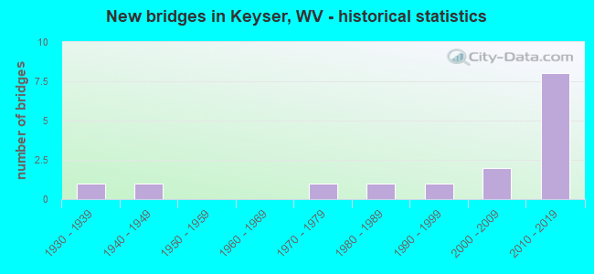
- New bridges - historical statistics
- 11930-1939
- 11940-1949
- 11970-1979
- 11980-1989
- 11990-1999
- 22000-2009
- 82010-2019


- Bridge Condition - Deck
- 83.3%Satisfactory
- 16.7%Fair

- Bridge Condition - Superstructure
- 33.3%Good
- 50.0%Satisfactory
- 16.7%Fair

- Bridge Condition - Substructure
- 16.7%Good
- 83.3%Satisfactory

- Bridge Condition - Channel
- 12.5%Very good
- 37.5%Good
- 12.5%Satisfactory
- 37.5%Fair

- Bridge Condition - Culverts
- 50.0%Good
- 50.0%Fair
Find on map >> Show street view
Structure Number: 29A006, Location: 0.01 MI S OF WV 93 T (Lat: 39.394819, Lng: -79.012069), Route carried "on" structure: US 22000, Year Built: 1977, Status: Open, Structure Length: 2.41m (7.91ft), Average Daily Traffic: 5,600 (year 2018), Truck Traffic: 12%, Average Future Daily Traffic: 6,888 (year 2038), Design Load: HS 20, Features Intersected: NEW CREEK, Facility Carried by Structure: US 220 T
Minimum Vertical Clearance: 30+ m (98+ ft), Kilometerpoint: 17.638, Lanes on structure: 2, Owner: State Highway Agency, Approaching Roadway Width: 7.6m (24.9ft), Material/Design: Steel, Design/Construction: Stringer/Multi-beam, Number Of Spans In Main Unit: 1, Length of Maximum Span: 22.9m (75.1ft), Curb or Sidewalk Widths: Left: 0.3m (1.0ft), Right: 0.3m (1.0ft), Curb-To-Curb Width: 7.3m (24.0ft), Out-to-Out Width: 8.5m (27.9ft)
Condition: Deck: Satisfactory, Superstructure: Satisfactory, Substructure: Satisfactory, Channel: Fair, Operating Rating: 87.1 metric tons, Method Used To Determine Operating Rating: Load Factor (LF), Inventory Rating: 51.7 metric tons, Method Used To Determine Inventory Rating: Load Factor (LF), Structural Evaluation: Equal to present minimum criteria, Deck Geometry: High priority of replacement, Waterway Adequacy: Equal to present desirable criteria, Approach Roadway Alignment: Equal to present desirable criteria, Length Of Structure Improvement: 2.44m (8.01ft), Designated Inspection Frequency: Every 24 months, Inspection Date: September 2020, Bridge Improvement Cost: $600,000, Roadway Improvement Cost: $150,000, Total Project Cost: $750,000 ( Estimate for 2016), Deck Structure Type: Concrete Cast-file-Place
Find on map >> Show street view
Structure Number: 29A023, Location: 0.01 MI S OF CR 46/10 SLS (Lat: 39.415139, Lng: -78.930739), Route carried "on" structure: County highway 1600, Year Built: 1949, Status: Open, Structure Length: 1.23m (4.04ft), Average Daily Traffic: 1,500 (year 2019), Truck Traffic: 6%, Average Future Daily Traffic: 1,650 (year 2039), Features Intersected: CABIN RUN, Facility Carried by Structure: CR 16 SLS
Minimum Vertical Clearance: 30+ m (98+ ft), Kilometerpoint: 16.979, Lanes on structure: 2, Owner: State Highway Agency, Approaching Roadway Width: 8.5m (27.9ft), Skew: 2 degrees, Material/Design: Steel, Design/Construction: Culvert, Number Of Spans In Main Unit: 2, Length of Maximum Span: 5.7m (18.7ft)
Condition: Channel: Fair, Culverts: Fair, Operating Rating: 53.5 metric tons, Method Used To Determine Operating Rating: Field evaluation and documented engineering judgment, Inventory Rating: 24.5 metric tons, Method Used To Determine Inventory Rating: Field evaluation and documented engineering judgment, Structural Evaluation: Somewhat better than minimum adequacy, Waterway Adequacy: Better than present minimum criteria, Approach Roadway Alignment: Better than present minimum criteria, Length Of Structure Improvement: 1.22m (4.00ft), Designated Inspection Frequency: Every 24 months, Inspection Date: December 2020, Bridge Improvement Cost: $300,000, Roadway Improvement Cost: $25,000, Total Project Cost: $325,000 ( Estimate for 2014)
Find on map >> Show street view
Structure Number: 29A043, Location: 0.04 MI EAST OF CR 14 SLS (Lat: 39.434789, Lng: -78.963719), Route carried "on" structure: County highway 4608, Year Built: 1936, Status: Open, Structure Length: 0.85m (2.79ft), Average Daily Traffic: 350 (year 2020), Truck Traffic: 7%, Average Future Daily Traffic: 389 (year 2040), Features Intersected: LIMESTONE RUN, Facility Carried by Structure: CR 14 SLS
Minimum Vertical Clearance: 30+ m (98+ ft), Kilometerpoint: 0.064, Lanes on structure: 2, Owner: State Highway Agency, Approaching Roadway Width: 5.8m (19.0ft), Skew: 2 degrees, Material/Design: Concrete, Design/Construction: Slab, Number Of Spans In Main Unit: 1, Length of Maximum Span: 6.7m (22.0ft), Curb or Sidewalk Widths: Left: 0.2m (0.7ft), Right: 0.2m (0.7ft), Curb-To-Curb Width: 7.2m (23.6ft), Out-to-Out Width: 7.7m (25.3ft)
Condition: Deck: Fair, Superstructure: Fair, Substructure: Satisfactory, Channel: Good, Operating Rating: 47.2 metric tons, Method Used To Determine Operating Rating: Field evaluation and documented engineering judgment, Inventory Rating: 21.8 metric tons, Method Used To Determine Inventory Rating: Field evaluation and documented engineering judgment, Structural Evaluation: Somewhat better than minimum adequacy, Deck Geometry: Meets minimum limits, Waterway Adequacy: Equal to present minimum criteria, Approach Roadway Alignment: Equal to present desirable criteria, Length Of Structure Improvement: 0.85m (2.79ft), Designated Inspection Frequency: Every 24 months, Inspection Date: November 2021, Bridge Improvement Cost: $60,000, Roadway Improvement Cost: $5,000, Total Project Cost: $65,000, Deck Structure Type: Concrete Cast-file-Place, Wearing Surface/Protective System: Wearing Surface: Bituminous
Find on map >> Show street view
Structure Number: 29A06, Location: 0.02 MI E 0F CR 46/10 SLS (Lat: 39.426619, Lng: -78.908461), Route carried "on" structure: County highway 4605, Year Built: 1997, Status: Open, Structure Length: 1.46m (4.79ft), Average Daily Traffic: 70 (year 2017), Average Future Daily Traffic: 88 (year 2037), Design Load: HS 25 or greater, Features Intersected: CABIN RUN, Facility Carried by Structure: CR 46/5 SLS
Minimum Vertical Clearance: 30+ m (98+ ft), Kilometerpoint: 0.064, Lanes on structure: 2, Owner: State Highway Agency, Approaching Roadway Width: 5.5m (18.0ft), Skew: 1 degrees, Material/Design: Prestressed concrete, Design/Construction: Box Beam or Girders - Multiple, Number Of Spans In Main Unit: 1, Length of Maximum Span: 13.5m (44.3ft), Curb-To-Curb Width: 7.2m (23.6ft), Out-to-Out Width: 7.5m (24.6ft)
Condition: Deck: Satisfactory, Superstructure: Satisfactory, Substructure: Satisfactory, Channel: Satisfactory, Operating Rating: 49.9 metric tons, Method Used To Determine Operating Rating: Load Factor (LF), Inventory Rating: 29.9 metric tons, Method Used To Determine Inventory Rating: Load Factor (LF), Structural Evaluation: Equal to present minimum criteria, Deck Geometry: Somewhat better than minimum adequacy, Waterway Adequacy: Better than present minimum criteria, Approach Roadway Alignment: Better than present minimum criteria, Designated Inspection Frequency: Every 48 months, Inspection Date: May 2019, Deck Structure Type: Other, Wearing Surface/Protective System: Wearing Surface: Bituminous, Deck Protection: Epoxy Coated Reinforcing
Find on map >> Show street view
Structure Number: 29A074, Location: 0.77 MI S OF CR 220/5 SLS (Lat: 39.406169, Lng: -79.002931), Route carried "on" structure: US 22000, Year Built: 2000, Status: Open, Structure Length: 0.77m (2.53ft), Average Daily Traffic: 12,500 (year 2019), Truck Traffic: 12%, Average Future Daily Traffic: 13,750 (year 2039), Design Load: HS 25 or greater, Features Intersected: BLOCK RUN, Facility Carried by Structure: US 220 T
Minimum Vertical Clearance: 30+ m (98+ ft), Kilometerpoint: 19.199, Lanes on structure: 3, Base Highway Network: Yes, Owner: State Highway Agency, Approaching Roadway Width: 14.6m (47.9ft), Skew: 1 degrees, Material/Design: Concrete, Design/Construction: Culvert, Number Of Spans In Main Unit: 2, Length of Maximum Span: 3.4m (11.2ft)
Condition: Channel: Fair, Culverts: Good, Operating Rating: 88.9 metric tons, Method Used To Determine Operating Rating: Field evaluation and documented engineering judgment, Inventory Rating: 40.8 metric tons, Method Used To Determine Inventory Rating: Field evaluation and documented engineering judgment, Structural Evaluation: Better than present minimum criteria, Waterway Adequacy: Meets minimum limits, Approach Roadway Alignment: Equal to present desirable criteria, Designated Inspection Frequency: Every 24 months, Inspection Date: May 2021
Find on map >> Show street view
Structure Number: 29A08, Location: 0.43 MI E OF US 220 T (Lat: 39.439331, Lng: -78.971861), Route carried "on" structure: State highway 4600, Year Built: 2007, Status: Open, Structure Length: 3.15m (10.33ft), Average Daily Traffic: 7,200 (year 2018), Truck Traffic: 9%, Average Future Daily Traffic: 8,712 (year 2038), Design Load: HL 93, Features Intersected: NEW CREEK, Facility Carried by Structure: WV 46 F
Minimum Vertical Clearance: 30+ m (98+ ft), Kilometerpoint: 32.589, Lanes on structure: 3, Owner: State Highway Agency, Approaching Roadway Width: 8.2m (26.9ft), Material/Design: Steel, Design/Construction: Stringer/Multi-beam, Number Of Spans In Main Unit: 1, Length of Maximum Span: 30.5m (100.1ft), Curb or Sidewalk Widths: Left: 1.5m (4.9ft), Right: 1.5m (4.9ft), Curb-To-Curb Width: 13.4m (44.0ft), Out-to-Out Width: 17.1m (56.1ft)
Condition: Deck: Satisfactory, Superstructure: Good, Substructure: Good, Channel: Good, Operating Rating: 78.0 metric tons, Method Used To Determine Operating Rating: Load and Resistance Factor (LRFR), Inventory Rating: 59.9 metric tons, Method Used To Determine Inventory Rating: Load and Resistance Factor (LRFR), Structural Evaluation: Better than present minimum criteria, Deck Geometry: Somewhat better than minimum adequacy, Waterway Adequacy: Equal to present minimum criteria, Approach Roadway Alignment: Better than present minimum criteria, Designated Inspection Frequency: Every 48 months, Inspection Date: January 2020, Deck Structure Type: Concrete Cast-file-Place, Wearing Surface/Protective System: Deck Protection: Epoxy Coated Reinforcing
Find on map >> Show street view
Structure Number: 29A081, Location: 0.14 mile north of WV 46 (Lat: 39.442050, Lng: -78.975100), Route carried "on" structure: US 220, Year Built: 2012, Status: Open, Structure Length: 64.77m (212.50ft), Average Daily Traffic: 13,600 (year 2020), Truck Traffic: 8%, Average Future Daily Traffic: 16,320 (year 2040), Design Load: HL 93, Features Intersected: WV 46, CSX RR, Potomac R
Minimum Vertical Clearance: 30+ m (98+ ft), Kilometerpoint: 23.931, Lanes on structure: 2, Lanes under structure: 11, Owner: State Highway Agency, Approaching Roadway Width: 11.0m (36.1ft), Material/Design: Steel continuous, Design/Construction: Stringer/Multi-beam, Number Of Spans In Main Unit: 6, Number Of Approach Spans: 4, Length of Maximum Span: 70.1m (230.0ft), Curb or Sidewalk Widths: Left: 1.7m (5.6ft), Right: 0.0m, Curb-To-Curb Width: 14.6m (47.9ft), Out-to-Out Width: 17.0m (55.8ft)
Condition: Deck: Satisfactory, Superstructure: Good, Substructure: Satisfactory, Channel: Very good, Operating Rating: 46.3 metric tons, Method Used To Determine Operating Rating: Load and Resistance Factor (LRFR), Inventory Rating: 36.3 metric tons, Method Used To Determine Inventory Rating: Load and Resistance Factor (LRFR), Structural Evaluation: Equal to present minimum criteria, Deck Geometry: Superior to present desirable criteria, Underclear: Equal to present minimum criteria, Waterway Adequacy: Superior to present desirable criteria, Approach Roadway Alignment: Better than present minimum criteria, Designated Inspection Frequency: Every 24 months, Inspection Date: January 2021, Deck Structure Type: Concrete Cast-file-Place, Wearing Surface/Protective System: Deck Protection: Epoxy Coated Reinforcing
Find on map >> Show street view
Structure Number: 29A9, Location: 0.29 MI S OF WV 46 F (Lat: 39.436711, Lng: -78.975789), Route carried "on" structure: City street N0815, Year Built: 1989, Status: Open, Structure Length: 1.68m (5.51ft), Average Daily Traffic: 500 (year 2021), Truck Traffic: 6%, Average Future Daily Traffic: 630 (year 2041), Design Load: HS 20+Mod, Features Intersected: NEW CREEK, Facility Carried by Structure: HUGHES STREET
Minimum Vertical Clearance: 30+ m (98+ ft), Kilometerpoint: 0.016, Lanes on structure: 2, Owner: City or Municipal Highway Agency, Approaching Roadway Width: 7.3m (24.0ft), Material/Design: Prestressed concrete, Design/Construction: Box Beam or Girders - Multiple, Number Of Spans In Main Unit: 1, Length of Maximum Span: 15.7m (51.5ft), Curb-To-Curb Width: 7.1m (23.3ft), Out-to-Out Width: 7.3m (24.0ft)
Condition: Deck: Satisfactory, Superstructure: Satisfactory, Substructure: Satisfactory, Channel: Good, Operating Rating: 55.3 metric tons, Method Used To Determine Operating Rating: Load Factor (LF), Inventory Rating: 33.6 metric tons, Method Used To Determine Inventory Rating: Load Factor (LF), Structural Evaluation: Equal to present minimum criteria, Deck Geometry: Meets minimum limits, Waterway Adequacy: Equal to present desirable criteria, Approach Roadway Alignment: Somewhat better than minimum adequacy, Designated Inspection Frequency: Every 24 months, Inspection Date: June 2021, Deck Structure Type: Other, Wearing Surface/Protective System: Wearing Surface: Bituminous, Deck Protection: Epoxy Coated Reinforcing
Find on map >> Show street view
Structure Number: 29A081, Location: 0.14 mile north of WV 46 (Lat: 39.443158, Lng: -78.974061), Route carried "under" structure: City street , Year Built: 2012, Structure Length: 0. m, Average Daily Traffic: 10 (year 2013), Features Intersected: WV 46, CSX RR, Potomac R, Facility Carried by Structure: US 220 (T)
Minimum Vertical Clearance: 11.02m (36.15ft), Kilometerpoint: 0.000, Lanes on structure: 2, Lanes under structure: 2, Length of Maximum Span: 70.1m (230.0ft)
Find on map >> Show street view
Structure Number: 29A081, Location: 0.14 mile north of WV 46 (Lat: 39.442956, Lng: -78.974206), Route carried "under" structure: City street , Year Built: 2012, Structure Length: 0. m, Average Daily Traffic: 100 (year 2017), Features Intersected: WV 46, CSX RR, Potomac R, Facility Carried by Structure: US 220 (T)
Minimum Vertical Clearance: 11.33m (37.17ft), Kilometerpoint: 0.000, Lanes on structure: 2, Lanes under structure: 2, Length of Maximum Span: 70.1m (230.0ft)
Find on map >> Show street view
Structure Number: 29A081, Location: 0.14 mile north of WV 46 (Lat: 39.444483, Lng: -78.973086), Route carried "under" structure: City street , Year Built: 2012, Structure Length: 0. m, Average Daily Traffic: 50 (year 2017), Features Intersected: WV 46, CSX RR, Potomac R, Facility Carried by Structure: US 220 (T)
Minimum Vertical Clearance: 11.91m (39.07ft), Kilometerpoint: 0.000, Lanes on structure: 2, Lanes under structure: 2, Length of Maximum Span: 70.1m (230.0ft)
Find on map >> Show street view
Structure Number: 29A081, Location: 0.14 mile north of WV 46 (Lat: 39.444161, Lng: -78.973261), Route carried "under" structure: City street , Year Built: 2012, Structure Length: 0. m, Average Daily Traffic: 10 (year 2017), Features Intersected: WV 46, CSX RR, Potomac R, Facility Carried by Structure: US 220 (T)
Minimum Vertical Clearance: 12.29m (40.32ft), Kilometerpoint: 0.000, Lanes on structure: 2, Lanes under structure: 2, Length of Maximum Span: 70.1m (230.0ft)
Find on map >> Show street view
Structure Number: 29A081, Location: 0.14 mile north of WV 46 (Lat: 39.443881, Lng: -78.973450), Route carried "under" structure: City street , Year Built: 2012, Structure Length: 0. m, Average Daily Traffic: 10 (year 2017), Features Intersected: WV 46, CSX RR, Potomac R, Facility Carried by Structure: US 220 (T)
Minimum Vertical Clearance: 12.60m (41.34ft), Kilometerpoint: 0.000, Lanes on structure: 2, Length of Maximum Span: 70.1m (230.0ft)
Find on map >> Show street view
Structure Number: 29A081, Location: 0.14 mile north of WV 46 (Lat: 39.443500, Lng: -78.973719), Route carried "under" structure: City street , Year Built: 2012, Structure Length: 0. m, Average Daily Traffic: 50 (year 2017), Features Intersected: WV 46, CSX RR, Potomac R, Facility Carried by Structure: US 220 (T)
Minimum Vertical Clearance: 12.67m (41.57ft), Kilometerpoint: 0.000, Lanes on structure: 2, Lanes under structure: 2, Length of Maximum Span: 70.1m (230.0ft)
Find on map >> Show street view
Structure Number: 29A081, Location: 0.14 mile north of WV 46 (Lat: 39.442050, Lng: -78.975100), Route carried "under" structure: State highway 460, Year Built: 2012, Structure Length: 0. m, Average Daily Traffic: 5,300 (year 2020), Truck Traffic: 9%, Features Intersected: WV 46, CSX RR, Potomac R, Facility Carried by Structure: US 220 (T)
Minimum Vertical Clearance: 5.08m (16.67ft), Kilometerpoint: 31.897, Lanes on structure: 2, Lanes under structure: 2, Length of Maximum Span: 70.1m (230.0ft)