Bridge Statistics for Kewaskum, Wisconsin (WI)
Condition, Traffic, Stress, Structural Evaluation, Project Costs
- National Bridge Inventory (NBI) Statistics
- 11Number of bridges
- 75ft / 23.0mTotal length
- $978,000Total costs
- 44,134Total average daily traffic
- 701Total average daily truck traffic
- 62,968Total future (year 2039) average daily traffic
- National Bridge Inventory (NBI) Registered Bridges for Kewaskum
- No street view available for this location
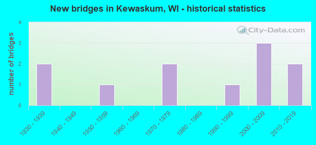
- New bridges - historical statistics
- 21930-1939
- 11950-1959
- 21970-1979
- 11990-1999
- 32000-2009
- 22010-2019


- Bridge Condition - Deck
- 10.0%Excellent
- 40.0%Good
- 40.0%Satisfactory
- 10.0%Poor

- Bridge Condition - Superstructure
- 10.0%Excellent
- 20.0%Very good
- 30.0%Good
- 20.0%Satisfactory
- 10.0%Fair
- 10.0%Serious

- Bridge Condition - Substructure
- 10.0%Excellent
- 30.0%Very good
- 50.0%Good
- 10.0%Fair

- Bridge Condition - Channel
- 10.0%Excellent
- 40.0%Very good
- 10.0%Good
- 40.0%Satisfactory
Find on map >> Show street view
Structure Number: B660006, Location: 1.3M E JCT CTH S (Lat: 43.535581, Lng: -88.195431), Route carried "on" structure: City street , Year Built: 2001, Status: Open, Structure Length: 1.63m (5.35ft), Average Daily Traffic: 268 (year 2019), Average Future Daily Traffic: 294 (year 2040), Design Load: HS 20, Features Intersected: E. BR MILWAUKEE R, Facility Carried by Structure: LRD EAST MORAINE D
Minimum Vertical Clearance: 30+ m (98+ ft), Kilometerpoint: 0.000, Lanes on structure: 2, Owner: Town or Township Highway Agency, Approaching Roadway Width: 7.9m (25.9ft), Material/Design: Prestressed concrete, Design/Construction: Stringer/Multi-beam, Number Of Spans In Main Unit: 1, Length of Maximum Span: 15.5m (50.9ft), Curb-To-Curb Width: 7.2m (23.6ft), Out-to-Out Width: 7.8m (25.6ft)
Condition: Deck: Satisfactory, Superstructure: Very good, Substructure: Very good, Channel: Good, Operating Rating: 49.0 metric tons, Method Used To Determine Operating Rating: Load Factor (LF), Inventory Rating: 29.2 metric tons, Method Used To Determine Inventory Rating: Load Factor (LF), Structural Evaluation: Better than present minimum criteria, Deck Geometry: Meets minimum limits, Waterway Adequacy: Equal to present desirable criteria, Approach Roadway Alignment: Equal to present desirable criteria, Designated Inspection Frequency: Every 24 months, Inspection Date: November 2021, Deck Structure Type: Concrete Cast-file-Place, Wearing Surface/Protective System: Wearing Surface: Monolithic Concrete, Deck Protection: Epoxy Coated Reinforcing
Find on map >> Show street view
Structure Number: B660086, Location: 0.2 MI N JCT STH 28 (Lat: 43.531281, Lng: -88.236414), Route carried "on" structure: US 45, Year Built: 1978, Status: Open, Structure Length: 6.45m (21.16ft), Average Daily Traffic: 7,300 (year 2019), Truck Traffic: 5%, Average Future Daily Traffic: 15,840 (year 2039), Design Load: HS 20, Features Intersected: EISENBAHN STATE TRAIL
Minimum Vertical Clearance: 30+ m (98+ ft), Kilometerpoint: 0.000, Lanes on structure: 2, Owner: State Highway Agency, Approaching Roadway Width: 13.4m (44.0ft), Skew: 4 degrees, Material/Design: Steel continuous, Design/Construction: Stringer/Multi-beam, Number Of Spans In Main Unit: 3, Length of Maximum Span: 23.9m (78.4ft), Curb-To-Curb Width: 13.4m (44.0ft), Out-to-Out Width: 14.1m (46.3ft)
Condition: Deck: Satisfactory, Superstructure: Good, Substructure: Good, Operating Rating: 53.9 metric tons, Method Used To Determine Operating Rating: Load Factor (LF), Inventory Rating: 30.8 metric tons, Method Used To Determine Inventory Rating: Load Factor (LF), Structural Evaluation: Better than present minimum criteria, Deck Geometry: Equal to present minimum criteria, Underclear: Equal to present desirable criteria, Approach Roadway Alignment: Equal to present desirable criteria, Designated Inspection Frequency: Every 24 months, Inspection Date: June 2020, Deck Structure Type: Concrete Cast-file-Place, Wearing Surface/Protective System: Wearing Surface: Low Slump Concrete
Find on map >> Show street view
Structure Number: B660089, Location: 0.3M W JCT USH 45 (Lat: 43.513747, Lng: -88.231286), Route carried "on" structure: County highway , Year Built: 1979, Status: Open, Structure Length: 1.15m (3.77ft), Average Daily Traffic: 2,100 (year 2019), Average Future Daily Traffic: 2,864 (year 2039), Design Load: HS 20, Features Intersected: BR MILWAUKEE RIVER, Facility Carried by Structure: CTH H
Minimum Vertical Clearance: 30+ m (98+ ft), Kilometerpoint: 0.000, Lanes on structure: 2, Owner: County Highway Agency, Approaching Roadway Width: 8.5m (27.9ft), Material/Design: Concrete, Design/Construction: Slab, Number Of Spans In Main Unit: 1, Length of Maximum Span: 11.0m (36.1ft), Curb-To-Curb Width: 12.2m (40.0ft), Out-to-Out Width: 12.8m (42.0ft)
Condition: Deck: Satisfactory, Superstructure: Satisfactory, Substructure: Good, Channel: Satisfactory, Operating Rating: 57.0 metric tons, Method Used To Determine Operating Rating: Load Factor (LF), Inventory Rating: 34.0 metric tons, Method Used To Determine Inventory Rating: Load Factor (LF), Structural Evaluation: Equal to present minimum criteria, Deck Geometry: Equal to present minimum criteria, Waterway Adequacy: Equal to present minimum criteria, Approach Roadway Alignment: Equal to present desirable criteria, Designated Inspection Frequency: Every 24 months, Inspection Date: November 2020, Deck Structure Type: Concrete Cast-file-Place, Wearing Surface/Protective System: Wearing Surface: Monolithic Concrete
Find on map >> Show street view
Structure Number: B660122, Location: 0.9M E JCT CTH S (Lat: 43.521136, Lng: -88.203283), Route carried "on" structure: State highway 28, Year Built: 1997, Status: Open, Structure Length: 1.98m (6.50ft), Average Daily Traffic: 3,400 (year 2019), Truck Traffic: 8%, Average Future Daily Traffic: 3,390 (year 2039), Design Load: HS 20, Features Intersected: E BR MILWAUKEE RIVER
Minimum Vertical Clearance: 30+ m (98+ ft), Kilometerpoint: 0.000, Lanes on structure: 2, Owner: State Highway Agency, Approaching Roadway Width: 11.0m (36.1ft), Skew: 1 degrees, Material/Design: Prestressed concrete, Design/Construction: Stringer/Multi-beam, Number Of Spans In Main Unit: 1, Length of Maximum Span: 19.0m (62.3ft), Curb-To-Curb Width: 10.8m (35.4ft), Out-to-Out Width: 11.7m (38.4ft)
Condition: Deck: Good, Superstructure: Very good, Substructure: Good, Channel: Very good, Operating Rating: 62.1 metric tons, Method Used To Determine Operating Rating: Load Factor (LF), Inventory Rating: 34.0 metric tons, Method Used To Determine Inventory Rating: Load Factor (LF), Structural Evaluation: Better than present minimum criteria, Deck Geometry: Somewhat better than minimum adequacy, Waterway Adequacy: Equal to present desirable criteria, Approach Roadway Alignment: Equal to present desirable criteria, Designated Inspection Frequency: Every 40 months, Inspection Date: May 2020, Deck Structure Type: Concrete Cast-file-Place, Wearing Surface/Protective System: Wearing Surface: Bituminous, Membrane: Other, Deck Protection: Epoxy Coated Reinforcing
Find on map >> Show street view
Structure Number: B660129, Location: 0.4 MI S JCT STH 28 (Lat: 43.516806, Lng: -88.225794), Route carried "on" structure: US 45, Year Built: 2003, Status: Open, Structure Length: 0.75m (2.46ft), Average Daily Traffic: 16,700 (year 2019), Average Future Daily Traffic: 27,400 (year 2039), Design Load: HS 20, Features Intersected: KEWASKUM CR
Minimum Vertical Clearance: 30+ m (98+ ft), Kilometerpoint: 0.000, Lanes on structure: 2, Owner: State Highway Agency, Approaching Roadway Width: 14.6m (47.9ft), Material/Design: Concrete continuous, Design/Construction: Culvert, Number Of Spans In Main Unit: 2, Length of Maximum Span: 3.7m (12.1ft), Curb or Sidewalk Widths: Left: 2.0m (6.6ft), Right: 2.0m (6.6ft)
Condition: Channel: Very good, Culverts: Very good, Operating Rating: 53.9 metric tons, Method Used To Determine Operating Rating: Field evaluation and documented engineering judgment, Inventory Rating: 32.4 metric tons, Method Used To Determine Inventory Rating: Field evaluation and documented engineering judgment, Structural Evaluation: Equal to present desirable criteria, Waterway Adequacy: Equal to present desirable criteria, Approach Roadway Alignment: Equal to present desirable criteria, Designated Inspection Frequency: Every 24 months, Inspection Date: September 2020, Deck Structure Type: Concrete Cast-file-Place, Wearing Surface/Protective System: Wearing Surface: Monolithic Concrete
Find on map >> Show street view
Structure Number: B660178, Location: TOWN OF KEWASKUM (Lat: 43.539378, Lng: -88.281053), Route carried "on" structure: City street , Year Built: 2008, Status: Open, Structure Length: 0.99m (3.25ft), Average Daily Traffic: 109 (year 2019), Truck Traffic: 10%, Average Future Daily Traffic: 119 (year 2039), Design Load: HS 20, Features Intersected: TRIB. TO MILWAUKEE R., Facility Carried by Structure: LRD TOWNLINE RD
Minimum Vertical Clearance: 30+ m (98+ ft), Kilometerpoint: 0.000, Lanes on structure: 2, Owner: Town or Township Highway Agency, Approaching Roadway Width: 7.3m (24.0ft), Material/Design: Concrete, Design/Construction: Slab, Number Of Spans In Main Unit: 1, Length of Maximum Span: 9.1m (29.9ft), Curb-To-Curb Width: 7.3m (24.0ft), Out-to-Out Width: 8.1m (26.6ft)
Condition: Deck: Good, Superstructure: Good, Substructure: Very good, Channel: Satisfactory, Operating Rating: 73.0 metric tons, Method Used To Determine Operating Rating: Load Factor (LF), Inventory Rating: 43.7 metric tons, Method Used To Determine Inventory Rating: Load Factor (LF), Structural Evaluation: Better than present minimum criteria, Deck Geometry: Somewhat better than minimum adequacy, Waterway Adequacy: Equal to present desirable criteria, Approach Roadway Alignment: Equal to present desirable criteria, Designated Inspection Frequency: Every 24 months, Inspection Date: December 2020, Deck Structure Type: Concrete Cast-file-Place, Wearing Surface/Protective System: Wearing Surface: Monolithic Concrete, Deck Protection: Epoxy Coated Reinforcing
Find on map >> Show street view
Structure Number: B660184, Location: 0.3 M E JCT USH 45 (Lat: 43.520853, Lng: -88.222297), Route carried "on" structure: State highway 28, Year Built: 2014, Status: Open, Structure Length: 3.49m (11.45ft), Average Daily Traffic: 8,200 (year 2019), Average Future Daily Traffic: 8,200 (year 2039), Design Load: HL 93, Features Intersected: MILWAUKEE RIVER
Minimum Vertical Clearance: 30+ m (98+ ft), Kilometerpoint: 0.000, Lanes on structure: 2, Owner: State Highway Agency, Approaching Roadway Width: 14.6m (47.9ft), Material/Design: Concrete, Design/Construction: Slab, Number Of Spans In Main Unit: 2, Length of Maximum Span: 17.1m (56.1ft), Curb or Sidewalk Widths: Left: 2.0m (6.6ft), Right: 2.0m (6.6ft), Curb-To-Curb Width: 12.2m (40.0ft), Out-to-Out Width: 16.6m (54.5ft)
Condition: Deck: Good, Superstructure: Good, Substructure: Very good, Channel: Very good, Operating Rating: 50.5 metric tons, Method Used To Determine Operating Rating: Load and Resistance Factor Rating (LRFR) rating reported by rating factor(RF) method using HL-93 loadings, Inventory Rating: 38.9 metric tons, Method Used To Determine Inventory Rating: Load and Resistance Factor Rating (LRFR) rating reported by rating factor(RF) method using HL-93 loadings, Structural Evaluation: Better than present minimum criteria, Deck Geometry: Somewhat better than minimum adequacy, Waterway Adequacy: Superior to present desirable criteria, Approach Roadway Alignment: Equal to present desirable criteria, Designated Inspection Frequency: Every 48 months, Underwater Inspection Frequency: Every 72 months, Inspection Date: September 2020, Underwater Inspection Date: April 2020, Deck Structure Type: Concrete Cast-file-Place, Wearing Surface/Protective System: Wearing Surface: Monolithic Concrete, Deck Protection: Epoxy Coated Reinforcing
Find on map >> Show street view
Structure Number: B660197, Location: TOWN OF KEWASKUM (Lat: 43.499192, Lng: -88.233236), Route carried "on" structure: City street , Year Built: 2019, Status: Open, Structure Length: 1.20m (3.94ft), Average Daily Traffic: 610 (year 2019), Truck Traffic: 9%, Average Future Daily Traffic: 340 (year 2039), Design Load: HL 93, Features Intersected: KEWASKUM CREEK, Facility Carried by Structure: LRD KETTLE VIEW DR
Minimum Vertical Clearance: 30+ m (98+ ft), Kilometerpoint: 0.000, Lanes on structure: 2, Owner: Town or Township Highway Agency, Approaching Roadway Width: 7.9m (25.9ft), Material/Design: Concrete, Design/Construction: Slab, Number Of Spans In Main Unit: 1, Length of Maximum Span: 11.3m (37.1ft), Curb-To-Curb Width: 7.9m (25.9ft), Out-to-Out Width: 8.7m (28.5ft)
Condition: Deck: Excellent, Superstructure: Excellent, Substructure: Excellent, Channel: Excellent, Operating Rating: 54.4 metric tons, Method Used To Determine Operating Rating: Load and Resistance Factor Rating (LRFR) rating reported by rating factor(RF) method using HL-93 loadings, Inventory Rating: 40.2 metric tons, Method Used To Determine Inventory Rating: Load and Resistance Factor Rating (LRFR) rating reported by rating factor(RF) method using HL-93 loadings, Structural Evaluation: Superior to present desirable criteria, Deck Geometry: Somewhat better than minimum adequacy, Waterway Adequacy: Superior to present desirable criteria, Approach Roadway Alignment: Equal to present desirable criteria, Designated Inspection Frequency: Every 24 months, Inspection Date: Febuary 2020, Deck Structure Type: Concrete Cast-file-Place, Wearing Surface/Protective System: Wearing Surface: Monolithic Concrete, Deck Protection: Epoxy Coated Reinforcing
Find on map >> Show street view
Structure Number: B660655, Location: 1.0M E JCT USH 45 (Lat: 43.497803, Lng: -88.194822), Route carried "on" structure: County highway , Year Built: 1950, Status: Open, Structure Length: 3.99m (13.09ft), Average Daily Traffic: 4,500 (year 2019), Average Future Daily Traffic: 3,481 (year 2039), Design Load: H 20, Features Intersected: MILWAUKEE RIVER, Facility Carried by Structure: CTH H
Minimum Vertical Clearance: 30+ m (98+ ft), Kilometerpoint: 0.000, Lanes on structure: 2, Owner: County Highway Agency, Approaching Roadway Width: 9.1m (29.9ft), Material/Design: Steel continuous, Design/Construction: Stringer/Multi-beam, Number Of Spans In Main Unit: 2, Length of Maximum Span: 19.2m (63.0ft), Curb-To-Curb Width: 7.3m (24.0ft), Out-to-Out Width: 8.1m (26.6ft)
Condition: Deck: Poor, Superstructure: Fair, Substructure: Fair, Channel: Very good, Operating Rating: 35.9 metric tons, Method Used To Determine Operating Rating: Load Factor (LF), Inventory Rating: 21.1 metric tons, Method Used To Determine Inventory Rating: Load Factor (LF), Structural Evaluation: Somewhat better than minimum adequacy, Deck Geometry: High priority of replacement, Waterway Adequacy: Equal to present desirable criteria, Approach Roadway Alignment: Equal to present desirable criteria, Length Of Structure Improvement: 4.45m (14.60ft), Designated Inspection Frequency: Every 24 months, Inspection Date: November 2020, Bridge Improvement Cost: $551,000, Roadway Improvement Cost: $55,000, Total Project Cost: $827,000 ( Estimate for 2021), Deck Structure Type: Concrete Cast-file-Place, Wearing Surface/Protective System: Wearing Surface: Monolithic Concrete
Find on map >> Show street view
Structure Number: P660911, Location: TOWN OF KEWASKUM (Lat: 43.513133, Lng: -88.281381), Route carried "on" structure: City street , Year Built: 1930, Status: Open, Structure Length: 0.67m (2.20ft), Average Daily Traffic: 219 (year 2019), Average Future Daily Traffic: 240 (year 2039), Features Intersected: TRIB. TO MILWAUKEE R, Facility Carried by Structure: LRD TOWNLINE RD
Minimum Vertical Clearance: 30+ m (98+ ft), Kilometerpoint: 0.000, Lanes on structure: 2, Owner: Town or Township Highway Agency, Approaching Roadway Width: 6.7m (22.0ft), Material/Design: Steel, Design/Construction: Stringer/Multi-beam, Number Of Spans In Main Unit: 1, Length of Maximum Span: 6.4m (21.0ft), Curb-To-Curb Width: 7.0m (23.0ft), Out-to-Out Width: 7.4m (24.3ft)
Condition: Deck: Satisfactory, Superstructure: Satisfactory, Substructure: Good, Channel: Satisfactory, Operating Rating: 26.1 metric tons, Method Used To Determine Operating Rating: Load Factor (LF), Inventory Rating: 14.6 metric tons, Method Used To Determine Inventory Rating: Load Factor (LF), Structural Evaluation: Meets minimum limits, Deck Geometry: Meets minimum limits, Waterway Adequacy: Equal to present desirable criteria, Approach Roadway Alignment: Equal to present desirable criteria, Designated Inspection Frequency: Every 24 months, Inspection Date: December 2020, Deck Structure Type: Concrete Cast-file-Place, Wearing Surface/Protective System: Wearing Surface: Bituminous
Find on map >> Show street view
Structure Number: P660913, Location: TOWN OF KEWASKUM (Lat: 43.499178, Lng: -88.233253), Route carried "on" structure: City street , Year Built: 1930, Status: Posted for load, Structure Length: 0.68m (2.23ft), Average Daily Traffic: 728 (year 2019), Average Future Daily Traffic: 800 (year 2040), Features Intersected: KEWASKUM CREEK, Facility Carried by Structure: LRD BADGER RD
Minimum Vertical Clearance: 30+ m (98+ ft), Kilometerpoint: 0.000, Lanes on structure: 2, Owner: Town or Township Highway Agency, Approaching Roadway Width: 6.7m (22.0ft), Material/Design: Steel, Design/Construction: Stringer/Multi-beam, Number Of Spans In Main Unit: 1, Length of Maximum Span: 6.7m (22.0ft), Curb-To-Curb Width: 7.0m (23.0ft), Out-to-Out Width: 7.1m (23.3ft)
Condition: Deck: Good, Superstructure: Serious, Substructure: Good, Channel: Satisfactory, Operating Rating: 22.9 metric tons, Method Used To Determine Operating Rating: Load Factor (LF), Inventory Rating: 13.0 metric tons, Method Used To Determine Inventory Rating: Load Factor (LF), Structural Evaluation: High priority of corrective action, Deck Geometry: Meets minimum limits, Waterway Adequacy: Equal to present desirable criteria, Approach Roadway Alignment: Equal to present desirable criteria, Bridge Posting: Required (Relationship of Operating Rating to Maximum Legal Load: 0.1 - 9.9% below), Length Of Structure Improvement: 1.13m (3.71ft), Designated Inspection Frequency: Every 12 months, Inspection Date: November 2021, Bridge Improvement Cost: $100,000, Roadway Improvement Cost: $10,000, Total Project Cost: $151,000 ( Estimate for 2021), Deck Structure Type: Concrete Cast-file-Place, Wearing Surface/Protective System: Wearing Surface: Bituminous