Bridge Statistics for Kerrtown, Pennsylvania (PA)
Condition, Traffic, Stress, Structural Evaluation, Project Costs
- National Bridge Inventory (NBI) Statistics
- 21Number of bridges
- 220ft / 67.3mTotal length
- $1,670,000Total costs
- 131,193Total average daily traffic
- 23,093Total average daily truck traffic
- National Bridge Inventory (NBI) Registered Bridges for Kerrtown
- No street view available for this location
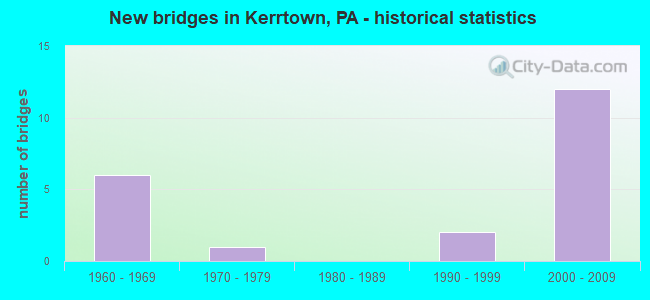
- New bridges - historical statistics
- 61960-1969
- 11970-1979
- 21990-1999
- 122000-2009


- Bridge Condition - Deck
- 22.2%Very good
- 77.8%Good

- Bridge Condition - Superstructure
- 55.6%Very good
- 33.3%Good
- 11.1%Satisfactory

- Bridge Condition - Substructure
- 22.2%Very good
- 66.7%Good
- 11.1%Fair

- Bridge Condition - Channel
- 12.5%Excellent
- 12.5%Very good
- 12.5%Good
- 25.0%Satisfactory
- 12.5%Fair
- 25.0%Poor
Find on map >> Show street view
Structure Number: 12993, Location: VERNON TOWNSHIP (Lat: 41.618039, Lng: -80.173364), Route carried "on" structure: Interstate 79, Year Built: 1969, Status: Open, Structure Length: 1.13m (3.71ft), Average Daily Traffic: 6,732 (year 2021), Truck Traffic: 29%, Average Future Daily Traffic: 9,924 (year 2032), Design Load: HS 20+Mod, Features Intersected: OVER VAN HORN RUN
Minimum Vertical Clearance: 30+ m (98+ ft), Kilometerpoint: 16.204, Lanes on structure: 2, Base Highway Network: Yes, Owner: State Highway Agency, Approaching Roadway Width: 7.3m (24.0ft), Skew: 14 degrees, Material/Design: Concrete, Design/Construction: Culvert, Number Of Spans In Main Unit: 1, Length of Maximum Span: 11.3m (37.1ft)
Condition: Channel: Fair, Culverts: Satisfactory, Operating Rating: 49.0 metric tons, Method Used To Determine Operating Rating: Allowable Stress (AS), Inventory Rating: 32.7 metric tons, Method Used To Determine Inventory Rating: Allowable Stress (AS), Structural Evaluation: Equal to present minimum criteria, Waterway Adequacy: Superior to present desirable criteria, Approach Roadway Alignment: Equal to present desirable criteria, Length Of Structure Improvement: 1.70m (5.58ft), Designated Inspection Frequency: Every 48 months, Inspection Date: Febuary 2021, Bridge Improvement Cost: $52,000, Roadway Improvement Cost: $153,000, Total Project Cost: $702,000
Find on map >> Show street view
Structure Number: 12999, Location: VERNON TOWNSHIP (Lat: 41.625489, Lng: -80.185344), Route carried "on" structure: Interstate 79, Year Built: 1969, Status: Open, Structure Length: 1.22m (4.00ft), Average Daily Traffic: 7,763 (year 2021), Truck Traffic: 20%, Average Future Daily Traffic: 11,433 (year 2032), Design Load: HS 20+Mod, Features Intersected: OVER VAN HORN RUN
Minimum Vertical Clearance: 30+ m (98+ ft), Kilometerpoint: 16.884, Lanes on structure: 3, Base Highway Network: Yes, Owner: State Highway Agency, Approaching Roadway Width: 14.3m (46.9ft), Skew: 4 degrees, Material/Design: Concrete, Design/Construction: Culvert, Number Of Spans In Main Unit: 1, Length of Maximum Span: 12.2m (40.0ft)
Condition: Channel: Satisfactory, Culverts: Satisfactory, Operating Rating: 49.0 metric tons, Method Used To Determine Operating Rating: Allowable Stress (AS), Inventory Rating: 32.7 metric tons, Method Used To Determine Inventory Rating: Allowable Stress (AS), Structural Evaluation: Equal to present minimum criteria, Waterway Adequacy: Superior to present desirable criteria, Approach Roadway Alignment: Equal to present desirable criteria, Length Of Structure Improvement: 1.40m (4.59ft), Designated Inspection Frequency: Every 48 months, Inspection Date: October 2019
Find on map >> Show street view
Structure Number: 13231, Location: UNION TOWNSHIP (Lat: 41.591194, Lng: -80.158836), Route carried "on" structure: State highway , Year Built: 1974, Status: Open, Structure Length: 0.61m (2.00ft), Average Daily Traffic: 2,065 (year 2022), Truck Traffic: 7%, Average Future Daily Traffic: 2,741 (year 2032), Design Load: HS 20, Features Intersected: OVER FRENCH CREEK TRIB, Facility Carried by Structure: SR 2003,MERCER PK.
Minimum Vertical Clearance: 30+ m (98+ ft), Kilometerpoint: 6.420, Lanes on structure: 2, Owner: State Highway Agency, Approaching Roadway Width: 6.4m (21.0ft), Material/Design: Steel, Design/Construction: Culvert, Number Of Spans In Main Unit: 1, Length of Maximum Span: 6.1m (20.0ft)
Condition: Channel: Satisfactory, Culverts: Satisfactory, Operating Rating: 49.0 metric tons, Method Used To Determine Operating Rating: Field evaluation and documented engineering judgment, Inventory Rating: 32.7 metric tons, Method Used To Determine Inventory Rating: Field evaluation and documented engineering judgment, Structural Evaluation: Equal to present minimum criteria, Waterway Adequacy: Superior to present desirable criteria, Approach Roadway Alignment: Equal to present desirable criteria, Length Of Structure Improvement: 0.60m (1.97ft), Designated Inspection Frequency: Every 24 months, Inspection Date: May 2020, Bridge Improvement Cost: $10,000, Roadway Improvement Cost: $45,000, Total Project Cost: $137,000
Find on map >> Show street view
Structure Number: 13325, Location: VERNON TOWNSHIP (Lat: 41.616481, Lng: -80.171742), Route carried "on" structure: State highway , Year Built: 1969, Year Reconstructed: 2017, Status: Open, Structure Length: 12.31m (40.39ft), Average Daily Traffic: 603 (year 2021), Truck Traffic: 8%, Average Future Daily Traffic: 791 (year 2032), Design Load: HL 93, Features Intersected: OVER SR 79,NB/SB, Facility Carried by Structure: SR 3025,KENNEDY HL
Minimum Vertical Clearance: 30+ m (98+ ft), Kilometerpoint: 3.364, Lanes on structure: 2, Lanes under structure: 8, Owner: State Highway Agency, Approaching Roadway Width: 6.1m (20.0ft), Skew: 9 degrees, Material/Design: Prestressed concrete, Design/Construction: Stringer/Multi-beam, Number Of Spans In Main Unit: 6, Length of Maximum Span: 22.6m (74.1ft), Curb or Sidewalk Widths: Left: 0.2m (0.7ft), Right: 0.2m (0.7ft), Curb-To-Curb Width: 9.8m (32.2ft), Out-to-Out Width: 11.0m (36.1ft)
Condition: Deck: Good, Superstructure: Satisfactory, Substructure: Fair, Operating Rating: 59.0 metric tons, Method Used To Determine Operating Rating: Load and Resistance Factor (LRFR), Inventory Rating: 25.4 metric tons, Method Used To Determine Inventory Rating: Load and Resistance Factor (LRFR), Structural Evaluation: Somewhat better than minimum adequacy, Deck Geometry: Equal to present minimum criteria, Underclear: Somewhat better than minimum adequacy, Approach Roadway Alignment: Equal to present minimum criteria, Length Of Structure Improvement: 13.20m (43.31ft), Designated Inspection Frequency: Every 24 months, Inspection Date: March 2020, Bridge Improvement Cost: $62,000, Roadway Improvement Cost: $181,000, Total Project Cost: $831,000, Deck Structure Type: Concrete Cast-file-Place, Wearing Surface/Protective System: Wearing Surface: Bituminous, Membrane: Other
Find on map >> Show street view
Structure Number: 13326, Location: VERNON TOWNSHIP (Lat: 41.617897, Lng: -80.170533), Route carried "on" structure: State highway , Year Built: 1996, Status: Open, Structure Length: 0.94m (3.08ft), Average Daily Traffic: 5,849 (year 2022), Truck Traffic: 6%, Average Future Daily Traffic: 7,519 (year 2032), Design Load: H 20, Features Intersected: OVER VAN HORNE RUN, Facility Carried by Structure: SR 3025,KENNEDY HL
Minimum Vertical Clearance: 30+ m (98+ ft), Kilometerpoint: 3.364, Lanes on structure: 2, Owner: State Highway Agency, Approaching Roadway Width: 9.1m (29.9ft), Skew: 1 degrees, Material/Design: Concrete, Design/Construction: Culvert, Number Of Spans In Main Unit: 2, Length of Maximum Span: 4.3m (14.1ft)
Condition: Channel: Poor, Culverts: Satisfactory, Inventory Rating: 99.8 metric tons, Method Used To Determine Inventory Rating: Load Factor (LF), Structural Evaluation: Equal to present minimum criteria, Waterway Adequacy: Superior to present desirable criteria, Approach Roadway Alignment: Equal to present desirable criteria, Length Of Structure Improvement: 1.60m (5.25ft), Designated Inspection Frequency: Every 24 months, Inspection Date: September 2020
Find on map >> Show street view
Structure Number: 13495, Location: 2 MI. S. MEADVILLE (Lat: 41.592078, Lng: -80.172039), Route carried "on" structure: City street 7228, Year Built: 1969, Status: Open, Structure Length: 1.28m (4.20ft), Average Daily Traffic: 280 (year 2020), Truck Traffic: 1%, Average Future Daily Traffic: 350 (year 2040), Design Load: HS 20, Features Intersected: OVER UNNAMED RUN, Facility Carried by Structure: T-704,KENNEDY HILL
Minimum Vertical Clearance: 30+ m (98+ ft), Kilometerpoint: 0.000, Lanes on structure: 2, Owner: Town or Township Highway Agency, Approaching Roadway Width: 5.5m (18.0ft), Skew: 2 degrees, Material/Design: Prestressed concrete, Design/Construction: Box Beam or Girders - Single/Spread, Number Of Spans In Main Unit: 1, Length of Maximum Span: 12.2m (40.0ft), Curb or Sidewalk Widths: Left: 0.2m (0.7ft), Right: 0.2m (0.7ft), Curb-To-Curb Width: 9.6m (31.5ft), Out-to-Out Width: 10.8m (35.4ft)
Condition: Deck: Good, Superstructure: Good, Substructure: Good, Channel: Poor, Operating Rating: 40.8 metric tons, Method Used To Determine Operating Rating: Load Factor (LF), Inventory Rating: 23.6 metric tons, Method Used To Determine Inventory Rating: Load Factor (LF), Structural Evaluation: Equal to present minimum criteria, Deck Geometry: Equal to present minimum criteria, Waterway Adequacy: Better than present minimum criteria, Approach Roadway Alignment: Equal to present desirable criteria, Length Of Structure Improvement: 1.60m (5.25ft), Designated Inspection Frequency: Every 24 months, Inspection Date: July 2020, Deck Structure Type: Corrugated Steel, Wearing Surface/Protective System: Wearing Surface: Bituminous, Deck Protection: Epoxy Coated Reinforcing
Find on map >> Show street view
Structure Number: 39613, Location: WEST MEAD TOWNSHIP (Lat: 41.589294, Lng: -80.150333), Route carried "on" structure: State highway , Year Built: 1997, Status: Open, Structure Length: 5.36m (17.59ft), Average Daily Traffic: 2,002 (year 2022), Truck Traffic: 4%, Average Future Daily Traffic: 1,730 (year 2032), Design Load: HS 25 or greater, Features Intersected: OVER FRENCH CREEK, Facility Carried by Structure: SR 2008,WILSON SHT
Minimum Vertical Clearance: 30+ m (98+ ft), Kilometerpoint: 0.586, Lanes on structure: 2, Owner: State Highway Agency, Approaching Roadway Width: 8.8m (28.9ft), Material/Design: Steel, Design/Construction: Stringer/Multi-beam, Number Of Spans In Main Unit: 1, Length of Maximum Span: 52.4m (171.9ft), Curb or Sidewalk Widths: Left: 0.2m (0.7ft), Right: 0.2m (0.7ft), Curb-To-Curb Width: 8.6m (28.2ft), Out-to-Out Width: 9.7m (31.8ft)
Condition: Deck: Good, Superstructure: Good, Substructure: Good, Channel: Good, Operating Rating: 74.4 metric tons, Method Used To Determine Operating Rating: Load Factor (LF), Inventory Rating: 42.6 metric tons, Method Used To Determine Inventory Rating: Load Factor (LF), Structural Evaluation: Better than present minimum criteria, Deck Geometry: Meets minimum limits, Waterway Adequacy: Meets minimum limits, Approach Roadway Alignment: Equal to present desirable criteria, Length Of Structure Improvement: 6.30m (20.67ft), Designated Inspection Frequency: Every 48 months, Inspection Date: June 2019, Deck Structure Type: Concrete Cast-file-Place, Wearing Surface/Protective System: Wearing Surface: Monolithic Concrete, Deck Protection: Epoxy Coated Reinforcing
Find on map >> Show street view
Structure Number: 42014, Location: UNION TOWNSHIP (Lat: 41.588506, Lng: -80.173119), Route carried "on" structure: Interstate 79, Year Built: 2003, Status: Open, Structure Length: 6.16m (20.21ft), Average Daily Traffic: 6,732 (year 2021), Truck Traffic: 29%, Average Future Daily Traffic: 9,924 (year 2032), Design Load: HS 25 or greater, Features Intersected: OVER NS R.R.,T-701
Minimum Vertical Clearance: 30+ m (98+ ft), Kilometerpoint: 12.154, Lanes on structure: 2, Lanes under structure: 2, Base Highway Network: Yes, Owner: State Highway Agency, Approaching Roadway Width: 13.1m (43.0ft), Skew: 13 degrees, Material/Design: Prestressed concrete continuous, Design/Construction: Box Beam or Girders - Multiple, Number Of Spans In Main Unit: 2, Length of Maximum Span: 30.5m (100.1ft), Curb or Sidewalk Widths: Left: 0.2m (0.7ft), Right: 0.2m (0.7ft), Curb-To-Curb Width: 12.8m (42.0ft), Out-to-Out Width: 13.7m (44.9ft)
Condition: Deck: Good, Superstructure: Very good, Substructure: Good, Operating Rating: 72.6 metric tons, Method Used To Determine Operating Rating: Load Factor (LF), Inventory Rating: 39.9 metric tons, Method Used To Determine Inventory Rating: Load Factor (LF), Structural Evaluation: Better than present minimum criteria, Deck Geometry: Equal to present desirable criteria, Underclear: High priority of corrective action, Approach Roadway Alignment: Equal to present desirable criteria, Length Of Structure Improvement: 7.10m (23.29ft), Designated Inspection Frequency: Every 48 months, Inspection Date: October 2019, Deck Structure Type: Concrete Cast-file-Place, Wearing Surface/Protective System: Wearing Surface: Bituminous, Membrane: Preformed Fabric, Deck Protection: Epoxy Coated Reinforcing
Find on map >> Show street view
Structure Number: 42015, Location: UNION TOWNSHIP (Lat: 41.591958, Lng: -80.171028), Route carried "on" structure: Interstate 79, Year Built: 2003, Status: Open, Structure Length: 9.51m (31.20ft), Average Daily Traffic: 6,732 (year 2021), Truck Traffic: 29%, Average Future Daily Traffic: 9,924 (year 2032), Design Load: HS 25 or greater, Features Intersected: OVER REC.TRAIL & FNCH.CK
Minimum Vertical Clearance: 30+ m (98+ ft), Kilometerpoint: 12.923, Lanes on structure: 2, Base Highway Network: Yes, Owner: State Highway Agency, Approaching Roadway Width: 12.8m (42.0ft), Skew: 12 degrees, Material/Design: Prestressed concrete continuous, Design/Construction: Stringer/Multi-beam, Number Of Spans In Main Unit: 2, Length of Maximum Span: 46.6m (152.9ft), Curb or Sidewalk Widths: Left: 0.2m (0.7ft), Right: 0.2m (0.7ft), Curb-To-Curb Width: 12.8m (42.0ft), Out-to-Out Width: 13.7m (44.9ft)
Condition: Deck: Very good, Superstructure: Good, Substructure: Good, Channel: Excellent, Operating Rating: 82.6 metric tons, Method Used To Determine Operating Rating: Load and Resistance Factor (LRFR), Inventory Rating: 42.6 metric tons, Method Used To Determine Inventory Rating: Load and Resistance Factor (LRFR), Structural Evaluation: Better than present minimum criteria, Deck Geometry: Equal to present desirable criteria, Waterway Adequacy: Superior to present desirable criteria, Approach Roadway Alignment: Equal to present desirable criteria, Length Of Structure Improvement: 10.50m (34.45ft), Designated Inspection Frequency: Every 48 months, Inspection Date: June 2020, Deck Structure Type: Concrete Cast-file-Place, Wearing Surface/Protective System: Wearing Surface: Bituminous, Deck Protection: Epoxy Coated Reinforcing
Find on map >> Show street view
Structure Number: 42363, Location: UNION TOWNSHIP (Lat: 41.592064, Lng: -80.171406), Route carried "on" structure: Interstate 79, Year Built: 2004, Status: Open, Structure Length: 8.99m (29.49ft), Average Daily Traffic: 6,999 (year 2021), Truck Traffic: 36%, Average Future Daily Traffic: 11,306 (year 2032), Design Load: HL 93, Features Intersected: OVER BIKE TRAIL,TR.FRENC
Minimum Vertical Clearance: 30+ m (98+ ft), Kilometerpoint: 12.941, Lanes on structure: 2, Base Highway Network: Yes, Owner: State Highway Agency, Approaching Roadway Width: 13.1m (43.0ft), Skew: 12 degrees, Material/Design: Prestressed concrete continuous, Design/Construction: Stringer/Multi-beam, Number Of Spans In Main Unit: 2, Length of Maximum Span: 44.5m (146.0ft), Curb or Sidewalk Widths: Left: 0.2m (0.7ft), Right: 0.2m (0.7ft), Curb-To-Curb Width: 12.9m (42.3ft), Out-to-Out Width: 13.7m (44.9ft)
Condition: Deck: Very good, Superstructure: Very good, Substructure: Very good, Channel: Very good, Operating Rating: 89.8 metric tons, Method Used To Determine Operating Rating: Load and Resistance Factor (LRFR), Inventory Rating: 43.5 metric tons, Method Used To Determine Inventory Rating: Load and Resistance Factor (LRFR), Structural Evaluation: Equal to present desirable criteria, Deck Geometry: Superior to present desirable criteria, Waterway Adequacy: Superior to present desirable criteria, Approach Roadway Alignment: Equal to present desirable criteria, Length Of Structure Improvement: 10.00m (32.81ft), Designated Inspection Frequency: Every 48 months, Inspection Date: June 2020, Deck Structure Type: Concrete Cast-file-Place, Wearing Surface/Protective System: Wearing Surface: Bituminous, Deck Protection: Epoxy Coated Reinforcing
Find on map >> Show street view
Structure Number: 42395, Location: UNION TOWNSHIP (Lat: 41.588458, Lng: -80.173572), Route carried "on" structure: Interstate 79, Year Built: 2004, Status: Open, Structure Length: 6.16m (20.21ft), Average Daily Traffic: 6,999 (year 2021), Truck Traffic: 36%, Average Future Daily Traffic: 11,306 (year 2032), Design Load: HL 93, Features Intersected: OVER T-701 & NS RR
Minimum Vertical Clearance: 30+ m (98+ ft), Kilometerpoint: 12.191, Lanes on structure: 2, Lanes under structure: 2, Base Highway Network: Yes, Owner: State Highway Agency, Approaching Roadway Width: 12.2m (40.0ft), Skew: 13 degrees, Material/Design: Prestressed concrete continuous, Design/Construction: Box Beam or Girders - Multiple, Number Of Spans In Main Unit: 2, Length of Maximum Span: 30.5m (100.1ft), Curb or Sidewalk Widths: Left: 0.2m (0.7ft), Right: 0.2m (0.7ft), Curb-To-Curb Width: 12.8m (42.0ft), Out-to-Out Width: 13.7m (44.9ft)
Condition: Deck: Good, Superstructure: Very good, Substructure: Good, Operating Rating: 72.6 metric tons, Method Used To Determine Operating Rating: Load and Resistance Factor (LRFR), Inventory Rating: 39.9 metric tons, Method Used To Determine Inventory Rating: Load and Resistance Factor (LRFR), Structural Evaluation: Better than present minimum criteria, Deck Geometry: Equal to present desirable criteria, Underclear: Meets minimum limits, Approach Roadway Alignment: Equal to present desirable criteria, Length Of Structure Improvement: 7.10m (23.29ft), Designated Inspection Frequency: Every 48 months, Inspection Date: October 2019, Deck Structure Type: Concrete Cast-file-Place, Wearing Surface/Protective System: Wearing Surface: Bituminous, Deck Protection: Epoxy Coated Reinforcing
Find on map >> Show street view
Structure Number: 4489, Location: VERNON TOWNSHIP (Lat: 41.622600, Lng: -80.181969), Route carried "on" structure: Interstate 79, Year Built: 2008, Status: Open, Structure Length: 6.80m (22.31ft), Average Daily Traffic: 7,763 (year 2021), Truck Traffic: 20%, Average Future Daily Traffic: 11,433 (year 2032), Design Load: HL 93, Features Intersected: US 6 & US 322
Minimum Vertical Clearance: 30+ m (98+ ft), Kilometerpoint: 16.884, Lanes on structure: 3, Lanes under structure: 8, Base Highway Network: Yes, Owner: State Highway Agency, Approaching Roadway Width: 11.6m (38.1ft), Skew: 15 degrees, Material/Design: Steel, Design/Construction: Stringer/Multi-beam, Number Of Spans In Main Unit: 1, Length of Maximum Span: 67.4m (221.1ft), Curb or Sidewalk Widths: Left: 0.2m (0.7ft), Right: 0.2m (0.7ft), Curb-To-Curb Width: 13.4m (44.0ft), Out-to-Out Width: 14.4m (47.2ft)
Condition: Deck: Good, Superstructure: Very good, Substructure: Very good, Operating Rating: 70.8 metric tons, Method Used To Determine Operating Rating: Load and Resistance Factor (LRFR), Inventory Rating: 42.6 metric tons, Method Used To Determine Inventory Rating: Load and Resistance Factor (LRFR), Structural Evaluation: Equal to present desirable criteria, Deck Geometry: Meets minimum limits, Underclear: High priority of corrective action, Approach Roadway Alignment: Equal to present desirable criteria, Designated Inspection Frequency: Every 48 months, Inspection Date: June 2019, Deck Structure Type: Concrete Cast-file-Place, Wearing Surface/Protective System: Wearing Surface: Monolithic Concrete, Deck Protection: Epoxy Coated Reinforcing
Find on map >> Show street view
Structure Number: 45612, Location: VERNON TOWNSHIP (Lat: 41.621856, Lng: -80.179717), Route carried "on" structure: Interstate 79, Year Built: 2009, Status: Open, Structure Length: 6.80m (22.31ft), Average Daily Traffic: 7,747 (year 2021), Truck Traffic: 20%, Average Future Daily Traffic: 10,671 (year 2032), Design Load: HL 93, Features Intersected: US 6 & US 322
Minimum Vertical Clearance: 30+ m (98+ ft), Kilometerpoint: 16.921, Lanes on structure: 3, Lanes under structure: 5, Base Highway Network: Yes, Owner: State Highway Agency, Approaching Roadway Width: 11.0m (36.1ft), Skew: 5 degrees, Material/Design: Steel, Design/Construction: Stringer/Multi-beam, Number Of Spans In Main Unit: 1, Length of Maximum Span: 67.4m (221.1ft), Curb or Sidewalk Widths: Left: 0.2m (0.7ft), Right: 0.2m (0.7ft), Curb-To-Curb Width: 13.4m (44.0ft), Out-to-Out Width: 14.4m (47.2ft)
Condition: Deck: Good, Superstructure: Very good, Substructure: Good, Operating Rating: 70.8 metric tons, Method Used To Determine Operating Rating: Load Factor (LF), Inventory Rating: 42.6 metric tons, Method Used To Determine Inventory Rating: Load Factor (LF), Structural Evaluation: Better than present minimum criteria, Deck Geometry: Meets minimum limits, Underclear: Superior to present desirable criteria, Approach Roadway Alignment: Equal to present desirable criteria, Designated Inspection Frequency: Every 48 months, Inspection Date: June 2019, Deck Structure Type: Concrete Cast-file-Place, Wearing Surface/Protective System: Wearing Surface: Monolithic Concrete, Deck Protection: Epoxy Coated Reinforcing
Find on map >> Show street view
Structure Number: 13325, Location: VERNON TOWNSHIP (Lat: 41.616481, Lng: -80.171742), Route carried "under" structure: Interstate 79, Year Built: 1969, Structure Length: 0. m, Average Daily Traffic: 6,732 (year 2021), Truck Traffic: 29%, Features Intersected: OVER SR 79,NB/SB, Facility Carried by Structure: SR 3025,KENNEDY HL
Minimum Vertical Clearance: 5.26m (17.26ft), Kilometerpoint: 15.405, Lanes on structure: 2, Lanes under structure: 4, Material/Design: Prestressed concrete, Design/Construction: Stringer/Multi-beam, Length of Maximum Span: 22.6m (74.1ft)
Find on map >> Show street view
Structure Number: 13325, Location: VERNON TOWNSHIP (Lat: 41.616481, Lng: -80.171742), Route carried "under" structure: Interstate 79, Year Built: 1969, Structure Length: 0. m, Average Daily Traffic: 6,999 (year 2021), Truck Traffic: 36%, Features Intersected: OVER SR 79,NB/SB, Facility Carried by Structure: SR 3025,KENNEDY HL
Minimum Vertical Clearance: 5.46m (17.91ft), Kilometerpoint: 15.374, Lanes on structure: 2, Lanes under structure: 4, Material/Design: Prestressed concrete, Design/Construction: Stringer/Multi-beam, Length of Maximum Span: 22.6m (74.1ft)
Find on map >> Show street view
Structure Number: 42014, Location: UNION TOWNSHIP (Lat: 41.588506, Lng: -80.173119), Route carried "under" structure: City street , Year Built: 2003, Structure Length: 0. m, Average Daily Traffic: 50 (year 2003), Features Intersected: OVER NS R.R.,T-701, Facility Carried by Structure: SR 79,NB
Minimum Vertical Clearance: 6.25m (20.51ft), Kilometerpoint: 0.000, Lanes on structure: 2, Lanes under structure: 2, Material/Design: Prestressed concrete continuous, Design/Construction: Box Beam or Girders - Multiple, Length of Maximum Span: 30.5m (100.1ft)
Find on map >> Show street view
Structure Number: 42395, Location: UNION TOWNSHIP (Lat: 41.588458, Lng: -80.173572), Route carried "under" structure: City street , Year Built: 2004, Structure Length: 0. m, Average Daily Traffic: 100 (year 1999), Truck Traffic: 1%, Features Intersected: OVER T-701 & NS RR, Facility Carried by Structure: SR 79, SB
Minimum Vertical Clearance: 7.03m (23.06ft), Kilometerpoint: 0.000, Lanes on structure: 2, Lanes under structure: 2, Material/Design: Prestressed concrete continuous, Design/Construction: Box Beam or Girders - Multiple, Length of Maximum Span: 30.5m (100.1ft)
Find on map >> Show street view
Structure Number: 4489, Location: VERNON TOWNSHIP (Lat: 41.622600, Lng: -80.181969), Route carried "under" structure: US 6, Year Built: 2008, Structure Length: 0. m, Average Daily Traffic: 12,228 (year 2022), Truck Traffic: 5%, Features Intersected: US 6 & US 322, Facility Carried by Structure: I-79 SOUTHBOUND
Minimum Vertical Clearance: 5.12m (16.80ft), Kilometerpoint: 34.017, Lanes on structure: 3, Lanes under structure: 4, Material/Design: Steel, Design/Construction: Stringer/Multi-beam, Length of Maximum Span: 67.4m (221.1ft)
Find on map >> Show street view
Structure Number: 4489, Location: VERNON TOWNSHIP (Lat: 41.622600, Lng: -80.181969), Route carried "under" structure: US 6, Year Built: 2008, Structure Length: 0. m, Average Daily Traffic: 12,295 (year 2022), Truck Traffic: 5%, Features Intersected: US 6 & US 322, Facility Carried by Structure: I-79 SOUTHBOUND
Minimum Vertical Clearance: 5.12m (16.80ft), Kilometerpoint: 33.986, Lanes on structure: 3, Lanes under structure: 4, Material/Design: Steel, Design/Construction: Stringer/Multi-beam, Length of Maximum Span: 67.4m (221.1ft)
Find on map >> Show street view
Structure Number: 45612, Location: VERNON TOWNSHIP (Lat: 41.621856, Lng: -80.179717), Route carried "under" structure: US 6, Year Built: 2009, Structure Length: 0. m, Average Daily Traffic: 12,295 (year 2022), Truck Traffic: 5%, Features Intersected: US 6 & US 322, Facility Carried by Structure: I-79 NORTHBOUND
Minimum Vertical Clearance: 5.43m (17.81ft), Kilometerpoint: 33.986, Lanes on structure: 3, Lanes under structure: 3, Material/Design: Steel, Design/Construction: Stringer/Multi-beam, Length of Maximum Span: 67.4m (221.1ft)
Find on map >> Show street view
Structure Number: 45612, Location: VERNON TOWNSHIP (Lat: 41.621856, Lng: -80.179717), Route carried "under" structure: US 6, Year Built: 2009, Structure Length: 0. m, Average Daily Traffic: 12,228 (year 2022), Truck Traffic: 5%, Features Intersected: US 6 & US 322, Facility Carried by Structure: I-79 NORTHBOUND
Minimum Vertical Clearance: 5.43m (17.81ft), Kilometerpoint: 34.017, Lanes on structure: 3, Lanes under structure: 2, Material/Design: Steel, Design/Construction: Stringer/Multi-beam, Length of Maximum Span: 67.4m (221.1ft)