Bridge Statistics for Kent City, Michigan (MI)
Condition, Traffic, Stress, Structural Evaluation, Project Costs
- National Bridge Inventory (NBI) Statistics
- 12Number of bridges
- 36ft / 11.5mTotal length
- 23,431Total average daily traffic
- 974Total average daily truck traffic
- 32,755Total future (year 2018) average daily traffic
- National Bridge Inventory (NBI) Registered Bridges for Kent City
- No street view available for this location
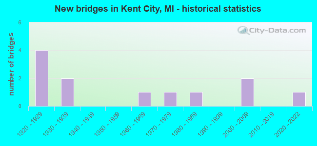
- New bridges - historical statistics
- 41920-1929
- 21930-1939
- 11960-1969
- 11970-1979
- 11980-1989
- 22000-2009
- 12020-2022


- Bridge Condition - Deck
- 12.5%Very good
- 12.5%Good
- 50.0%Satisfactory
- 12.5%Fair
- 12.5%Poor

- Bridge Condition - Superstructure
- 12.5%Good
- 37.5%Satisfactory
- 37.5%Fair
- 12.5%Poor

- Bridge Condition - Substructure
- 12.5%Very good
- 12.5%Good
- 25.0%Satisfactory
- 50.0%Fair

- Bridge Condition - Channel
- 25.0%Very good
- 25.0%Good
- 41.7%Satisfactory
- 8.3%Fair

- Bridge Condition - Culverts
- 25.0%Excellent
- 75.0%Good
Find on map >> Show street view
Structure Number: 4935, Location: IN KENT CITY (Lat: 43.219544, Lng: -85.755089), Route carried "on" structure: State highway 46, Year Built: 1977, Status: Open, Structure Length: 0.91m (2.99ft), Average Daily Traffic: 4,670 (year 2007), Truck Traffic: 8%, Average Future Daily Traffic: 6,681 (year 2018), Design Load: HS 20, Features Intersected: BALL CREEK
Minimum Vertical Clearance: 30.48m (100.00ft), Kilometerpoint: 2.882, Lanes on structure: 2, Base Highway Network: Yes (Inventory Route: 44, Subroute: 5), Owner: State Highway Agency, Approaching Roadway Width: 11.6m (38.1ft), Skew: 4 degrees, Material/Design: Prestressed concrete, Design/Construction: Box Beam or Girders - Multiple, Number Of Spans In Main Unit: 1, Length of Maximum Span: 9.1m (29.9ft), Curb-To-Curb Width: 12.5m (41.0ft), Out-to-Out Width: 12.9m (42.3ft)
Condition: Deck: Fair, Superstructure: Satisfactory, Substructure: Fair, Channel: Satisfactory, Operating Rating: 61.2 metric tons, Method Used To Determine Operating Rating: Load Factor (LF) rating reported by rating factor (RF) method using MS18 loading, Inventory Rating: 36.6 metric tons, Method Used To Determine Inventory Rating: Load Factor (LF) rating reported by rating factor (RF) method using MS18 loading, Structural Evaluation: Somewhat better than minimum adequacy, Deck Geometry: Equal to present minimum criteria, Waterway Adequacy: Equal to present desirable criteria, Approach Roadway Alignment: Better than present minimum criteria, Designated Inspection Frequency: Every 24 months, Inspection Date: October 2021, Deck Structure Type: Concrete Cast-file-Place, Wearing Surface/Protective System: Wearing Surface: Monolithic Concrete
Find on map >> Show street view
Structure Number: 4936, Location: 3.0 MI E OF KENT CITY (Lat: 43.219800, Lng: -85.688364), Route carried "on" structure: State highway 46, Year Built: 2000, Status: Open, Structure Length: 2.07m (6.79ft), Average Daily Traffic: 5,475 (year 2007), Truck Traffic: 10%, Average Future Daily Traffic: 5,607 (year 2018), Design Load: HS 25 or greater, Features Intersected: ROGUE RIVER
Minimum Vertical Clearance: 30.48m (100.00ft), Kilometerpoint: 8.292, Lanes on structure: 2, Base Highway Network: Yes (Inventory Route: 44, Subroute: 5), Owner: State Highway Agency, Approaching Roadway Width: 11.6m (38.1ft), Material/Design: Prestressed concrete, Design/Construction: Box Beam or Girders - Multiple, Number Of Spans In Main Unit: 1, Length of Maximum Span: 19.2m (63.0ft), Curb-To-Curb Width: 13.4m (44.0ft), Out-to-Out Width: 14.3m (46.9ft)
Condition: Deck: Very good, Superstructure: Good, Substructure: Very good, Channel: Good, Operating Rating: 92.7 metric tons, Method Used To Determine Operating Rating: Load Factor (LF) rating reported by rating factor (RF) method using MS18 loading, Inventory Rating: 55.4 metric tons, Method Used To Determine Inventory Rating: Load Factor (LF) rating reported by rating factor (RF) method using MS18 loading, Structural Evaluation: Better than present minimum criteria, Deck Geometry: Equal to present minimum criteria, Waterway Adequacy: Equal to present desirable criteria, Approach Roadway Alignment: Better than present minimum criteria, Designated Inspection Frequency: Every 24 months, Inspection Date: October 2021, Deck Structure Type: Concrete Cast-file-Place, Wearing Surface/Protective System: Deck Protection: Epoxy Coated Reinforcing
Find on map >> Show street view
Structure Number: 5036, Location: 0.20 MI E OF AFTON AVE (Lat: 43.234422, Lng: -85.697997), Route carried "on" structure: County highway , Year Built: 1937, Year Reconstructed: 1981, Status: Open, Structure Length: 1.43m (4.69ft), Average Daily Traffic: 700 (year 2013), Average Future Daily Traffic: 1,190 (year 2033), Design Load: HS 20+Mod, Features Intersected: ROGUE RIVER, Facility Carried by Structure: 18 MILE RD
Minimum Vertical Clearance: 30.48m (100.00ft), Kilometerpoint: 7.514, Lanes on structure: 2, Owner: County Highway Agency, Approaching Roadway Width: 6.7m (22.0ft), Material/Design: Steel, Design/Construction: Stringer/Multi-beam, Number Of Spans In Main Unit: 2, Length of Maximum Span: 7.0m (23.0ft), Curb-To-Curb Width: 10.1m (33.1ft), Out-to-Out Width: 10.9m (35.8ft)
Condition: Deck: Good, Superstructure: Satisfactory, Substructure: Fair, Channel: Good, Operating Rating: 27.1 metric tons, Method Used To Determine Operating Rating: Allowable Stress (AS), Inventory Rating: 15.3 metric tons, Method Used To Determine Inventory Rating: Allowable Stress (AS), Structural Evaluation: Meets minimum limits, Deck Geometry: Equal to present minimum criteria, Waterway Adequacy: Equal to present desirable criteria, Approach Roadway Alignment: Equal to present desirable criteria, Designated Inspection Frequency: Every 24 months, Inspection Date: October 2020, Deck Structure Type: Concrete Cast-file-Place, Wearing Surface/Protective System: Wearing Surface: Bituminous, Deck Protection: Epoxy Coated Reinforcing
Find on map >> Show street view
Structure Number: 5037, Location: 200 FT E OF TYRONE AVE (Lat: 43.263439, Lng: -85.731297), Route carried "on" structure: County highway , Year Built: 2021, Status: Open, Structure Length: 0.64m (2.10ft), Average Daily Traffic: 676 (year 2021), Truck Traffic: 8%, Average Future Daily Traffic: 1,007 (year 2041), Design Load: Greater than HL93, Features Intersected: WALTER CREEK DRAIN, Facility Carried by Structure: 20 MILE RD
Minimum Vertical Clearance: 30.48m (100.00ft), Kilometerpoint: 4.801, Lanes on structure: 2, Owner: County Highway Agency, Approaching Roadway Width: 14.0m (45.9ft), Material/Design: Concrete, Design/Construction: Culvert, Number Of Spans In Main Unit: 1, Length of Maximum Span: 6.4m (21.0ft)
Condition: Channel: Very good, Culverts: Excellent, Operating Rating: 69.3 metric tons, Method Used To Determine Operating Rating: Load and Resistance Factor Rating (LRFR) rating reported by rating factor(RF) method using HL-93 loadings, Inventory Rating: 53.5 metric tons, Method Used To Determine Inventory Rating: Load and Resistance Factor Rating (LRFR) rating reported by rating factor(RF) method using HL-93 loadings, Structural Evaluation: Superior to present desirable criteria, Waterway Adequacy: Equal to present desirable criteria, Approach Roadway Alignment: Equal to present desirable criteria, Designated Inspection Frequency: Every 24 months, Inspection Date: November 2021, Wearing Surface/Protective System: Wearing Surface: Bituminous
Find on map >> Show street view
Structure Number: 5038, Location: 0.40 MI W OF RED PINE DRV (Lat: 43.263725, Lng: -85.701039), Route carried "on" structure: County highway , Year Built: 1931, Year Reconstructed: 2021, Status: Open, Structure Length: 1.37m (4.49ft), Average Daily Traffic: 500 (year 2015), Average Future Daily Traffic: 850 (year 2035), Design Load: Greater than HL93, Features Intersected: ROGUE RIVER, Facility Carried by Structure: 20 MILE RD
Minimum Vertical Clearance: 30.48m (100.00ft), Kilometerpoint: 7.258, Lanes on structure: 2, Owner: County Highway Agency, Approaching Roadway Width: 7.9m (25.9ft), Material/Design: Steel continuous, Design/Construction: Stringer/Multi-beam, Number Of Spans In Main Unit: 2, Length of Maximum Span: 7.0m (23.0ft), Curb-To-Curb Width: 8.7m (28.5ft), Out-to-Out Width: 9.3m (30.5ft)
Condition: Deck: Satisfactory, Superstructure: Fair, Substructure: Good, Channel: Very good, Deck Geometry: Somewhat better than minimum adequacy, Waterway Adequacy: Equal to present desirable criteria, Approach Roadway Alignment: Equal to present desirable criteria, Designated Inspection Frequency: Every 24 months, Inspection Date: October 2020, Deck Structure Type: Concrete Cast-file-Place, Wearing Surface/Protective System: Wearing Surface: Monolithic Concrete, Deck Protection: Epoxy Coated Reinforcing
Find on map >> Show street view
Structure Number: 5044, Location: 0.90 MI S OF 20 MILE RD (Lat: 43.252214, Lng: -85.695347), Route carried "on" structure: County highway , Year Built: 1986, Status: Open, Structure Length: 0.61m (2.00ft), Average Daily Traffic: 981 (year 2005), Average Future Daily Traffic: 1,670 (year 2025), Design Load: HS 20+Mod, Features Intersected: SPRING CREEK, Facility Carried by Structure: RED PINE DRIVE
Minimum Vertical Clearance: 30.48m (100.00ft), Kilometerpoint: 2.038, Lanes on structure: 2, Owner: County Highway Agency, Approaching Roadway Width: 12.2m (40.0ft), Material/Design: Steel, Design/Construction: Culvert, Number Of Spans In Main Unit: 1, Length of Maximum Span: 6.1m (20.0ft)
Condition: Channel: Good, Culverts: Good, Operating Rating: 97.2 metric tons, Method Used To Determine Operating Rating: Load Factor (LF) rating reported by rating factor (RF) method using MS18 loading, Inventory Rating: 97.2 metric tons, Method Used To Determine Inventory Rating: Load Factor (LF) rating reported by rating factor (RF) method using MS18 loading, Structural Evaluation: Better than present minimum criteria, Waterway Adequacy: Equal to present desirable criteria, Approach Roadway Alignment: Equal to present desirable criteria, Designated Inspection Frequency: Every 24 months, Inspection Date: October 2020, Deck Structure Type: Concrete Cast-file-Place, Wearing Surface/Protective System: Wearing Surface: Bituminous
Find on map >> Show street view
Structure Number: 518, Location: 0.5 MI E OF BALL CREEK RD (Lat: 43.212308, Lng: -85.732153), Route carried "on" structure: County highway , Year Built: 1967, Status: Open, Structure Length: 0.76m (2.49ft), Average Daily Traffic: 365 (year 2005), Average Future Daily Traffic: 620 (year 2025), Design Load: HS 20+Mod, Features Intersected: BALL CREEK DRAIN, Facility Carried by Structure: RUSCO STREET
Minimum Vertical Clearance: 30.48m (100.00ft), Kilometerpoint: 1.535, Lanes on structure: 2, Owner: County Highway Agency, Approaching Roadway Width: 9.8m (32.2ft), Material/Design: Steel, Design/Construction: Culvert, Number Of Spans In Main Unit: 2, Length of Maximum Span: 3.6m (11.8ft)
Condition: Channel: Satisfactory, Culverts: Good, Operating Rating: 46.0 metric tons, Method Used To Determine Operating Rating: Load Factor (LF) rating reported by rating factor (RF) method using MS18 loading, Inventory Rating: 39.2 metric tons, Method Used To Determine Inventory Rating: Load Factor (LF) rating reported by rating factor (RF) method using MS18 loading, Structural Evaluation: Better than present minimum criteria, Waterway Adequacy: Equal to present desirable criteria, Approach Roadway Alignment: Equal to present desirable criteria, Designated Inspection Frequency: Every 24 months, Inspection Date: October 2020
Find on map >> Show street view
Structure Number: 5181, Location: 215 FT N OF 20 MILE RD (Lat: 43.264053, Lng: -85.731967), Route carried "on" structure: County highway , Year Built: 1925, Status: Open, Structure Length: 0.76m (2.49ft), Average Daily Traffic: 1,664 (year 2004), Average Future Daily Traffic: 2,830 (year 2024), Design Load: HS 20+Mod, Features Intersected: WALTER CREEK DRAIN, Facility Carried by Structure: TYRONE AVE
Minimum Vertical Clearance: 30.48m (100.00ft), Kilometerpoint: 4.934, Lanes on structure: 2, Owner: County Highway Agency, Approaching Roadway Width: 7.3m (24.0ft), Material/Design: Concrete, Design/Construction: Tee Beam, Number Of Spans In Main Unit: 1, Length of Maximum Span: 6.4m (21.0ft), Curb-To-Curb Width: 6.4m (21.0ft), Out-to-Out Width: 7.4m (24.3ft)
Condition: Deck: Satisfactory, Superstructure: Satisfactory, Substructure: Satisfactory, Channel: Very good, Operating Rating: 60.9 metric tons, Method Used To Determine Operating Rating: Load and Resistance Factor Rating (LRFR) rating reported by rating factor(RF) method using HL-93 loadings, Inventory Rating: 47.0 metric tons, Method Used To Determine Inventory Rating: Load and Resistance Factor Rating (LRFR) rating reported by rating factor(RF) method using HL-93 loadings, Structural Evaluation: Equal to present minimum criteria, Deck Geometry: High priority of replacement, Waterway Adequacy: Equal to present desirable criteria, Approach Roadway Alignment: Equal to present desirable criteria, Designated Inspection Frequency: Every 24 months, Inspection Date: October 2020, Deck Structure Type: Concrete Cast-file-Place, Wearing Surface/Protective System: Wearing Surface: Bituminous
Find on map >> Show street view
Structure Number: 5221, Location: 0.30 MI NW OF 17 MILE RD (Lat: 43.221894, Lng: -85.760564), Route carried "on" structure: City street , Year Built: 1925, Status: Posted for load, Structure Length: 0.73m (2.40ft), Average Daily Traffic: 2,100 (year 2004), Average Future Daily Traffic: 3,075 (year 2024), Design Load: HS 20+Mod, Features Intersected: BALL CREEK, Facility Carried by Structure: BALL CREEK RD
Minimum Vertical Clearance: 30.48m (100.00ft), Kilometerpoint: 2.401, Lanes on structure: 2, Owner: City or Municipal Highway Agency, Approaching Roadway Width: 8.5m (27.9ft), Material/Design: Concrete, Design/Construction: Tee Beam, Number Of Spans In Main Unit: 1, Length of Maximum Span: 6.4m (21.0ft), Curb-To-Curb Width: 7.9m (25.9ft), Out-to-Out Width: 9.0m (29.5ft)
Condition: Deck: Poor, Superstructure: Fair, Substructure: Satisfactory, Channel: Satisfactory, Operating Rating: 34.0 metric tons, Method Used To Determine Operating Rating: Field evaluation and documented engineering judgment, Inventory Rating: 20.2 metric tons, Method Used To Determine Inventory Rating: Field evaluation and documented engineering judgment, Structural Evaluation: Somewhat better than minimum adequacy, Deck Geometry: High priority of corrective action, Waterway Adequacy: Equal to present desirable criteria, Approach Roadway Alignment: Equal to present desirable criteria, Bridge Posting: Required (Relationship of Operating Rating to Maximum Legal Load: 10.0 - 19.9% below), Designated Inspection Frequency: Every 24 months, Inspection Date: September 2020, Deck Structure Type: Concrete Cast-file-Place, Wearing Surface/Protective System: Wearing Surface: Bituminous
Find on map >> Show street view
Structure Number: 5222, Location: 500 FT S.E. OF 17 MILE RD (Lat: 43.218958, Lng: -85.754692), Route carried "on" structure: City street , Year Built: 1925, Status: Posted for load, Structure Length: 0.73m (2.40ft), Average Daily Traffic: 2,100 (year 2004), Average Future Daily Traffic: 3,075 (year 2024), Design Load: HS 20+Mod, Features Intersected: BALL CREEK, Facility Carried by Structure: BALL CREEK RD.
Minimum Vertical Clearance: 30.48m (100.00ft), Kilometerpoint: 2.979, Lanes on structure: 2, Owner: City or Municipal Highway Agency, Approaching Roadway Width: 8.5m (27.9ft), Material/Design: Concrete, Design/Construction: Tee Beam, Number Of Spans In Main Unit: 1, Length of Maximum Span: 6.4m (21.0ft), Curb-To-Curb Width: 7.9m (25.9ft), Out-to-Out Width: 9.0m (29.5ft)
Condition: Deck: Satisfactory, Superstructure: Fair, Substructure: Fair, Channel: Satisfactory, Operating Rating: 34.0 metric tons, Method Used To Determine Operating Rating: Field evaluation and documented engineering judgment, Inventory Rating: 20.2 metric tons, Method Used To Determine Inventory Rating: Field evaluation and documented engineering judgment, Structural Evaluation: Somewhat better than minimum adequacy, Deck Geometry: High priority of corrective action, Waterway Adequacy: Equal to present desirable criteria, Approach Roadway Alignment: Equal to present desirable criteria, Bridge Posting: Required (Relationship of Operating Rating to Maximum Legal Load: 10.0 - 19.9% below), Designated Inspection Frequency: Every 24 months, Inspection Date: September 2020, Deck Structure Type: Concrete Cast-file-Place, Wearing Surface/Protective System: Wearing Surface: Bituminous
Find on map >> Show street view
Structure Number: 5223, Location: 0.14 MI SE OF MAIN ST (Lat: 43.216172, Lng: -85.749111), Route carried "on" structure: City street , Year Built: 1925, Status: Posted for load, Structure Length: 0.73m (2.40ft), Average Daily Traffic: 2,100 (year 2004), Average Future Daily Traffic: 3,075 (year 2024), Design Load: HS 20+Mod, Features Intersected: BALL CREEK, Facility Carried by Structure: BALL CREEK RD
Minimum Vertical Clearance: 30.48m (100.00ft), Kilometerpoint: 3.528, Lanes on structure: 2, Owner: City or Municipal Highway Agency, Approaching Roadway Width: 8.5m (27.9ft), Material/Design: Concrete, Design/Construction: Tee Beam, Number Of Spans In Main Unit: 1, Length of Maximum Span: 6.4m (21.0ft), Curb-To-Curb Width: 7.9m (25.9ft), Out-to-Out Width: 9.0m (29.5ft)
Condition: Deck: Satisfactory, Superstructure: Poor, Substructure: Fair, Channel: Fair, Operating Rating: 34.0 metric tons, Method Used To Determine Operating Rating: Field evaluation and documented engineering judgment, Inventory Rating: 20.2 metric tons, Method Used To Determine Inventory Rating: Field evaluation and documented engineering judgment, Structural Evaluation: Meets minimum limits, Deck Geometry: High priority of corrective action, Waterway Adequacy: Better than present minimum criteria, Approach Roadway Alignment: Equal to present desirable criteria, Bridge Posting: Required (Relationship of Operating Rating to Maximum Legal Load: 10.0 - 19.9% below), Designated Inspection Frequency: Every 24 months, Inspection Date: September 2020, Deck Structure Type: Concrete Cast-file-Place, Wearing Surface/Protective System: Wearing Surface: Bituminous
Find on map >> Show street view
Structure Number: 13211, Location: 0.3 MI N OF M-37 (Lat: 43.216547, Lng: -85.751133), Route carried "on" structure: City street , Year Built: 2003, Status: Open, Structure Length: 0.73m (2.40ft), Average Daily Traffic: 2,100 (year 2004), Average Future Daily Traffic: 3,075 (year 2024), Design Load: HS 20, Features Intersected: BALL CREEK, Facility Carried by Structure: SOUTH MAIN ST
Minimum Vertical Clearance: 30.48m (100.00ft), Kilometerpoint: 10.984, Lanes on structure: 2, Owner: City or Municipal Highway Agency, Approaching Roadway Width: 9.1m (29.9ft), Skew: 2 degrees, Material/Design: Concrete, Design/Construction: Culvert, Number Of Spans In Main Unit: 1, Length of Maximum Span: 6.1m (20.0ft), Curb-To-Curb Width: 14.9m (48.9ft), Out-to-Out Width: 17.2m (56.4ft)
Condition: Channel: Satisfactory, Culverts: Good, Operating Rating: 87.2 metric tons, Method Used To Determine Operating Rating: Load Factor (LF) rating reported by rating factor (RF) method using MS18 loading, Inventory Rating: 52.2 metric tons, Method Used To Determine Inventory Rating: Load Factor (LF) rating reported by rating factor (RF) method using MS18 loading, Structural Evaluation: Better than present minimum criteria, Deck Geometry: Superior to present desirable criteria, Waterway Adequacy: Equal to present desirable criteria, Approach Roadway Alignment: Equal to present desirable criteria, Designated Inspection Frequency: Every 24 months, Inspection Date: September 2020, Wearing Surface/Protective System: Wearing Surface: Bituminous