Bridge Statistics for Kenmar, Pennsylvania (PA)
Condition, Traffic, Stress, Structural Evaluation, Project Costs
- National Bridge Inventory (NBI) Statistics
- 14Number of bridges
- 118ft / 36.2mTotal length
- $56,000Total costs
- 130,191Total average daily traffic
- 8,757Total average daily truck traffic
- National Bridge Inventory (NBI) Registered Bridges for Kenmar
- No street view available for this location
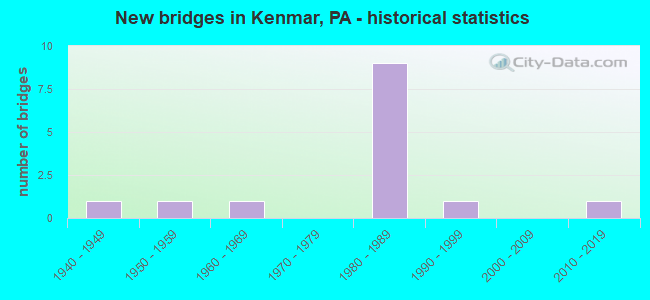
- New bridges - historical statistics
- 11940-1949
- 11950-1959
- 11960-1969
- 91980-1989
- 11990-1999
- 12010-2019

- Reconstructed bridges - Historical Statistics
- 11960-1969
- 01970-1979
- 01980-1989
- 01990-1999
- 12000-2009


- Bridge Condition - Deck
- 11.1%Excellent
- 11.1%Very good
- 66.7%Good
- 11.1%Fair

- Bridge Condition - Superstructure
- 33.3%Very good
- 55.6%Good
- 11.1%Satisfactory

- Bridge Condition - Substructure
- 11.1%Very good
- 55.6%Good
- 33.3%Satisfactory

- Bridge Condition - Channel
- 12.5%Very good
- 50.0%Good
- 37.5%Satisfactory
Find on map >> Show street view
Structure Number: 24635, Location: 1.3M E WLLMSPRT CTY LINE (Lat: 41.245772, Lng: -76.956872), Route carried "on" structure: Interstate 180, Year Built: 1982, Status: Open, Structure Length: 0.88m (2.89ft), Average Daily Traffic: 33,391 (year 2021), Truck Traffic: 11%, Average Future Daily Traffic: 59,603 (year 2032), Design Load: HS 20, Features Intersected: BULL RUN
Minimum Vertical Clearance: 30+ m (98+ ft), Kilometerpoint: 7.052, Lanes on structure: 4, Base Highway Network: Yes, Owner: State Highway Agency, Approaching Roadway Width: 23.2m (76.1ft), Skew: 22 degrees, Material/Design: Concrete, Design/Construction: Culvert, Number Of Spans In Main Unit: 2, Length of Maximum Span: 8.8m (28.9ft)
Condition: Channel: Good, Culverts: Good, Operating Rating: 89.8 metric tons, Method Used To Determine Operating Rating: Field evaluation and documented engineering judgment, Inventory Rating: 89.8 metric tons, Method Used To Determine Inventory Rating: Field evaluation and documented engineering judgment, Structural Evaluation: Better than present minimum criteria, Waterway Adequacy: Superior to present desirable criteria, Approach Roadway Alignment: Equal to present desirable criteria, Length Of Structure Improvement: 1.50m (4.92ft), Designated Inspection Frequency: Every 48 months, Inspection Date: January 2020
Find on map >> Show street view
Structure Number: 24637, Location: .5MI W MONTOURSVILLE (Lat: 41.246728, Lng: -76.945667), Route carried "on" structure: Interstate 180, Year Built: 1982, Status: Open, Structure Length: 10.15m (33.30ft), Average Daily Traffic: 13,730 (year 2021), Truck Traffic: 10%, Average Future Daily Traffic: 21,735 (year 2032), Design Load: HS 20, Features Intersected: OVER SR 2014/EAST 3RD ST
Minimum Vertical Clearance: 30+ m (98+ ft), Kilometerpoint: 8.658, Lanes on structure: 2, Lanes under structure: 4, Base Highway Network: Yes, Owner: State Highway Agency, Approaching Roadway Width: 11.6m (38.1ft), Skew: 15 degrees, Material/Design: Prestressed concrete, Design/Construction: Stringer/Multi-beam, Number Of Spans In Main Unit: 4, Length of Maximum Span: 29.9m (98.1ft), Curb-To-Curb Width: 12.8m (42.0ft), Out-to-Out Width: 13.7m (44.9ft)
Condition: Deck: Good, Superstructure: Good, Substructure: Satisfactory, Operating Rating: 55.3 metric tons, Method Used To Determine Operating Rating: Load Factor (LF), Inventory Rating: 32.7 metric tons, Method Used To Determine Inventory Rating: Load Factor (LF), Structural Evaluation: Equal to present minimum criteria, Deck Geometry: Equal to present desirable criteria, Underclear: Superior to present desirable criteria, Approach Roadway Alignment: Equal to present desirable criteria, Length Of Structure Improvement: 11.10m (36.42ft), Designated Inspection Frequency: Every 24 months, Inspection Date: January 2020, Deck Structure Type: Concrete Cast-file-Place, Wearing Surface/Protective System: Wearing Surface: Latex Concrete, Deck Protection: Epoxy Coated Reinforcing
Find on map >> Show street view
Structure Number: 24639, Location: .5MI WEST MONTOURSVILLE (Lat: 41.246747, Lng: -76.946103), Route carried "on" structure: Interstate 180, Year Built: 1982, Status: Open, Structure Length: 9.81m (32.19ft), Average Daily Traffic: 14,690 (year 2021), Truck Traffic: 11%, Average Future Daily Traffic: 21,238 (year 2032), Design Load: HS 20, Features Intersected: OVER SR2014,EAST 3RD ST.
Minimum Vertical Clearance: 30+ m (98+ ft), Kilometerpoint: 8.596, Lanes on structure: 2, Lanes under structure: 4, Base Highway Network: Yes, Owner: State Highway Agency, Approaching Roadway Width: 11.6m (38.1ft), Skew: 15 degrees, Material/Design: Prestressed concrete, Design/Construction: Stringer/Multi-beam, Number Of Spans In Main Unit: 4, Length of Maximum Span: 28.7m (94.2ft), Curb-To-Curb Width: 12.8m (42.0ft), Out-to-Out Width: 13.7m (44.9ft)
Condition: Deck: Good, Superstructure: Good, Substructure: Good, Operating Rating: 55.3 metric tons, Method Used To Determine Operating Rating: Load Factor (LF), Inventory Rating: 33.6 metric tons, Method Used To Determine Inventory Rating: Load Factor (LF), Structural Evaluation: Better than present minimum criteria, Deck Geometry: Equal to present desirable criteria, Underclear: Equal to present minimum criteria, Approach Roadway Alignment: Equal to present desirable criteria, Length Of Structure Improvement: 10.90m (35.76ft), Designated Inspection Frequency: Every 24 months, Inspection Date: January 2020, Deck Structure Type: Concrete Cast-file-Place, Wearing Surface/Protective System: Wearing Surface: Latex Concrete, Deck Protection: Bituminous
Find on map >> Show street view
Structure Number: 24866, Location: CITY OF WILLIAMSPORT (Lat: 41.253889, Lng: -76.972222), Route carried "on" structure: State highway , Year Built: 1949, Year Reconstructed: 2013, Status: Open, Structure Length: 1.68m (5.51ft), Average Daily Traffic: 7,987 (year 2020), Truck Traffic: 3%, Average Future Daily Traffic: 15,106 (year 2032), Design Load: HL 93, Features Intersected: OVER MILLERS RUN, Facility Carried by Structure: SR 2014
Minimum Vertical Clearance: 30+ m (98+ ft), Kilometerpoint: 10.820, Lanes on structure: 4, Owner: State Highway Agency, Approaching Roadway Width: 14.6m (47.9ft), Skew: 1 degrees, Material/Design: Steel, Design/Construction: Stringer/Multi-beam, Number Of Spans In Main Unit: 1, Length of Maximum Span: 15.8m (51.8ft), Curb or Sidewalk Widths: Left: 1.5m (4.9ft), Right: 1.5m (4.9ft), Curb-To-Curb Width: 14.6m (47.9ft), Out-to-Out Width: 18.3m (60.0ft)
Condition: Deck: Good, Superstructure: Good, Substructure: Satisfactory, Channel: Satisfactory, Operating Rating: 54.1 metric tons, Method Used To Determine Operating Rating: Assigned ratings based on Load and Resistance Factor Design (LRFD) reported by rating factor (RF) using HL93 loadings, Inventory Rating: 41.5 metric tons, Method Used To Determine Inventory Rating: Assigned ratings based on Load and Resistance Factor Design (LRFD) reported by rating factor (RF) using HL93 loadings, Structural Evaluation: Equal to present minimum criteria, Deck Geometry: High priority of replacement, Waterway Adequacy: Superior to present desirable criteria, Approach Roadway Alignment: Somewhat better than minimum adequacy, Length Of Structure Improvement: 1.70m (5.58ft), Designated Inspection Frequency: Every 48 months, Inspection Date: January 2020, Deck Structure Type: Concrete Cast-file-Place, Wearing Surface/Protective System: Wearing Surface: Monolithic Concrete, Deck Protection: Epoxy Coated Reinforcing
Find on map >> Show street view
Structure Number: 2489, Location: 1.5 MI NE OF WILLIAMSPORT (Lat: 41.262469, Lng: -76.971089), Route carried "on" structure: State highway , Year Built: 1964, Year Reconstructed: 1974, Status: Open, Structure Length: 1.01m (3.31ft), Average Daily Traffic: 7,819 (year 2022), Truck Traffic: 4%, Average Future Daily Traffic: 11,888 (year 2032), Design Load: HS 20, Features Intersected: OVER MILLERS RUN, Facility Carried by Structure: SR 2018
Minimum Vertical Clearance: 30+ m (98+ ft), Kilometerpoint: 3.327, Lanes on structure: 2, Owner: State Highway Agency, Approaching Roadway Width: 11.6m (38.1ft), Material/Design: Concrete, Design/Construction: Tee Beam, Number Of Spans In Main Unit: 1, Length of Maximum Span: 9.8m (32.2ft), Curb or Sidewalk Widths: Left: 1.5m (4.9ft), Right: 1.8m (5.9ft), Curb-To-Curb Width: 11.6m (38.1ft), Out-to-Out Width: 15.7m (51.5ft)
Condition: Deck: Fair, Superstructure: Good, Substructure: Good, Channel: Good, Operating Rating: 62.6 metric tons, Method Used To Determine Operating Rating: Load Factor (LF), Inventory Rating: 37.2 metric tons, Method Used To Determine Inventory Rating: Load Factor (LF), Structural Evaluation: Better than present minimum criteria, Deck Geometry: Somewhat better than minimum adequacy, Waterway Adequacy: Superior to present desirable criteria, Approach Roadway Alignment: Equal to present desirable criteria, Length Of Structure Improvement: 1.00m (3.28ft), Designated Inspection Frequency: Every 24 months, Inspection Date: January 2020, Bridge Improvement Cost: $4,000, Roadway Improvement Cost: $12,000, Total Project Cost: $56,000, Deck Structure Type: Concrete Cast-file-Place, Wearing Surface/Protective System: Wearing Surface: Bituminous, Membrane: Preformed Fabric
Find on map >> Show street view
Structure Number: 24891, Location: 0.1M E INTERSECT LR 41045 (Lat: 41.262875, Lng: -76.967789), Route carried "on" structure: State highway , Year Built: 1956, Status: Open, Structure Length: 0.64m (2.10ft), Average Daily Traffic: 3,081 (year 2020), Truck Traffic: 1%, Average Future Daily Traffic: 6,161 (year 2032), Features Intersected: BR OF MILLERS RUN, Facility Carried by Structure: SR-2018
Minimum Vertical Clearance: 30+ m (98+ ft), Kilometerpoint: 3.533, Lanes on structure: 2, Owner: State Highway Agency, Approaching Roadway Width: 8.2m (26.9ft), Skew: 3 degrees, Material/Design: Concrete, Design/Construction: Slab, Number Of Spans In Main Unit: 1, Length of Maximum Span: 6.1m (20.0ft), Curb or Sidewalk Widths: Left: 0.2m (0.7ft), Right: 1.5m (4.9ft), Curb-To-Curb Width: 9.8m (32.2ft), Out-to-Out Width: 12.0m (39.4ft)
Condition: Deck: Good, Superstructure: Satisfactory, Substructure: Good, Channel: Satisfactory, Operating Rating: 54.4 metric tons, Method Used To Determine Operating Rating: Field evaluation and documented engineering judgment, Inventory Rating: 32.7 metric tons, Method Used To Determine Inventory Rating: Field evaluation and documented engineering judgment, Structural Evaluation: Equal to present minimum criteria, Deck Geometry: Meets minimum limits, Waterway Adequacy: Better than present minimum criteria, Approach Roadway Alignment: Equal to present desirable criteria, Length Of Structure Improvement: 0.60m (1.97ft), Designated Inspection Frequency: Every 24 months, Inspection Date: January 2020, Wearing Surface/Protective System: Wearing Surface: Bituminous, Membrane: Preformed Fabric
Find on map >> Show street view
Structure Number: 24908, Location: .1 MI S INTERSECT L.R 18 (Lat: 41.249803, Lng: -76.973858), Route carried "on" structure: Ramp State highway , Year Built: 1982, Status: Open, Structure Length: 4.75m (15.58ft), Average Daily Traffic: 16,637 (year 2022), Truck Traffic: 1%, Average Future Daily Traffic: 13,633 (year 2032), Design Load: HS 20+Mod, Features Intersected: MILLER'S RUN, Facility Carried by Structure: S.R.2029
Minimum Vertical Clearance: 30+ m (98+ ft), Kilometerpoint: 0.000, Lanes on structure: 3, Owner: State Highway Agency, Approaching Roadway Width: 17.7m (58.1ft), Skew: 26 degrees, Material/Design: Steel continuous, Design/Construction: Stringer/Multi-beam, Number Of Spans In Main Unit: 2, Length of Maximum Span: 21.6m (70.9ft), Curb or Sidewalk Widths: Left: 0.2m (0.7ft), Right: 0.2m (0.7ft), Curb-To-Curb Width: 21.3m (69.9ft), Out-to-Out Width: 22.4m (73.5ft)
Condition: Deck: Good, Superstructure: Very good, Substructure: Satisfactory, Channel: Satisfactory, Operating Rating: 59.0 metric tons, Method Used To Determine Operating Rating: Load Factor (LF), Inventory Rating: 35.4 metric tons, Method Used To Determine Inventory Rating: Load Factor (LF), Structural Evaluation: Equal to present minimum criteria, Deck Geometry: Superior to present desirable criteria, Waterway Adequacy: Superior to present desirable criteria, Approach Roadway Alignment: Equal to present desirable criteria, Length Of Structure Improvement: 5.70m (18.70ft), Designated Inspection Frequency: Every 48 months, Inspection Date: January 2020, Deck Structure Type: Concrete Cast-file-Place, Wearing Surface/Protective System: Wearing Surface: Latex Concrete
Find on map >> Show street view
Structure Number: 24912, Location: 2 MI NW OF MONTOURSVILLE (Lat: 41.293256, Lng: -76.940489), Route carried "on" structure: State highway , Year Built: 1996, Status: Open, Structure Length: 2.01m (6.59ft), Average Daily Traffic: 686 (year 2022), Truck Traffic: 3%, Average Future Daily Traffic: 377 (year 2032), Design Load: HS 20, Features Intersected: OVER MILL CREEK, Facility Carried by Structure: SR 2031
Minimum Vertical Clearance: 30+ m (98+ ft), Kilometerpoint: 4.928, Lanes on structure: 2, Owner: State Highway Agency, Approaching Roadway Width: 8.2m (26.9ft), Skew: 4 degrees, Material/Design: Prestressed concrete, Design/Construction: Box Beam or Girders - Multiple, Number Of Spans In Main Unit: 1, Length of Maximum Span: 19.8m (65.0ft), Curb or Sidewalk Widths: Left: 0.3m (1.0ft), Right: 0.3m (1.0ft), Curb-To-Curb Width: 8.8m (28.9ft), Out-to-Out Width: 9.9m (32.5ft)
Condition: Deck: Very good, Superstructure: Very good, Substructure: Good, Channel: Good, Inventory Rating: 57.2 metric tons, Method Used To Determine Inventory Rating: Load Factor (LF), Structural Evaluation: Better than present minimum criteria, Deck Geometry: Somewhat better than minimum adequacy, Waterway Adequacy: Superior to present desirable criteria, Approach Roadway Alignment: Equal to present desirable criteria, Length Of Structure Improvement: 5.00m (16.40ft), Designated Inspection Frequency: Every 48 months, Inspection Date: January 2020, Deck Structure Type: Concrete Cast-file-Place, Wearing Surface/Protective System: Wearing Surface: Epoxy Overlay, Deck Protection: Epoxy Coated Reinforcing
Find on map >> Show street view
Structure Number: 25193, Location: .13MI S INTERSECT L.R.18 (Lat: 41.248511, Lng: -76.973803), Route carried "on" structure: Ramp State highway , Year Built: 1982, Status: Open, Structure Length: 4.11m (13.48ft), Average Daily Traffic: 1,899 (year 2021), Truck Traffic: 3%, Average Future Daily Traffic: 2,958 (year 2032), Design Load: HS 20+Mod, Features Intersected: MILLER'S RUN & T-480, Facility Carried by Structure: SR 8010 RAMP"F"S
Minimum Vertical Clearance: 30+ m (98+ ft), Kilometerpoint: 0.000, Lanes on structure: 2, Lanes under structure: 2, Base Highway Network: Yes, Owner: State Highway Agency, Approaching Roadway Width: 8.8m (28.9ft), Skew: 3 degrees, Material/Design: Prestressed concrete, Design/Construction: Box Beam or Girders - Single/Spread, Number Of Spans In Main Unit: 2, Length of Maximum Span: 20.4m (66.9ft), Curb or Sidewalk Widths: Left: 0.2m (0.7ft), Right: 0.2m (0.7ft), Curb-To-Curb Width: 9.6m (31.5ft), Out-to-Out Width: 10.6m (34.8ft)
Condition: Deck: Good, Superstructure: Good, Substructure: Good, Channel: Good, Operating Rating: 99.8 metric tons, Method Used To Determine Operating Rating: Load Factor (LF), Inventory Rating: 36.3 metric tons, Method Used To Determine Inventory Rating: Load Factor (LF), Structural Evaluation: Better than present minimum criteria, Deck Geometry: Somewhat better than minimum adequacy, Underclear: Better than present minimum criteria, Waterway Adequacy: Superior to present desirable criteria, Approach Roadway Alignment: Equal to present desirable criteria, Length Of Structure Improvement: 5.00m (16.40ft), Designated Inspection Frequency: Every 24 months, Inspection Date: July 2021, Deck Structure Type: Concrete Cast-file-Place, Wearing Surface/Protective System: Wearing Surface: Monolithic Concrete, Deck Protection: Epoxy Coated Reinforcing
Find on map >> Show street view
Structure Number: 4828, Location: SHERIDAN ST. IN FAXON (Lat: 41.253997, Lng: -76.972200), Route carried "on" structure: City street , Year Built: 2013, Status: Open, Structure Length: 1.16m (3.81ft), Average Daily Traffic: 6,315 (year 2021), Truck Traffic: 3%, Average Future Daily Traffic: 9,384 (year 2043), Design Load: HL 93, Features Intersected: MILLERS RUN, Facility Carried by Structure: T-616 SHERIDAN ST
Minimum Vertical Clearance: 30+ m (98+ ft), Kilometerpoint: 0.000, Lanes on structure: 2, Owner: Town or Township Highway Agency, Approaching Roadway Width: 9.1m (29.9ft), Skew: 1 degrees, Material/Design: Prestressed concrete, Design/Construction: Box Beam or Girders - Single/Spread, Number Of Spans In Main Unit: 1, Length of Maximum Span: 11.0m (36.1ft), Curb or Sidewalk Widths: Left: 1.7m (5.6ft), Right: 2.7m (8.9ft), Curb-To-Curb Width: 9.1m (29.9ft), Out-to-Out Width: 14.1m (46.3ft)
Condition: Deck: Excellent, Superstructure: Very good, Substructure: Very good, Channel: Very good, Operating Rating: 46.3 metric tons, Method Used To Determine Operating Rating: Assigned ratings based on Load and Resistance Factor Design (LRFD) reported by rating factor (RF) using HL93 loadings, Inventory Rating: 35.6 metric tons, Method Used To Determine Inventory Rating: Assigned ratings based on Load and Resistance Factor Design (LRFD) reported by rating factor (RF) using HL93 loadings, Structural Evaluation: Equal to present desirable criteria, Deck Geometry: High priority of corrective action, Waterway Adequacy: Superior to present desirable criteria, Approach Roadway Alignment: Equal to present desirable criteria, Designated Inspection Frequency: Every 24 months, Inspection Date: September 2021, Deck Structure Type: Concrete Cast-file-Place, Wearing Surface/Protective System: Wearing Surface: Monolithic Concrete, Deck Protection: Epoxy Coated Reinforcing
Find on map >> Show street view
Structure Number: 24637, Location: .5MI W MONTOURSVILLE (Lat: 41.246728, Lng: -76.945667), Route carried "under" structure: State highway , Year Built: 1982, Structure Length: 0. m, Average Daily Traffic: 5,560 (year 2021), Truck Traffic: 4%, Features Intersected: OVER SR 2014/EAST 3RD ST, Facility Carried by Structure: SR-0180 EBL
Minimum Vertical Clearance: 5.39m (17.68ft), Kilometerpoint: 12.873, Lanes on structure: 2, Lanes under structure: 2, Material/Design: Prestressed concrete, Design/Construction: Stringer/Multi-beam, Length of Maximum Span: 29.9m (98.1ft)
Find on map >> Show street view
Structure Number: 24637, Location: .5MI W MONTOURSVILLE (Lat: 41.246728, Lng: -76.945667), Route carried "under" structure: State highway , Year Built: 1982, Structure Length: 0. m, Average Daily Traffic: 6,418 (year 2021), Truck Traffic: 5%, Features Intersected: OVER SR 2014/EAST 3RD ST, Facility Carried by Structure: SR-0180 EBL
Minimum Vertical Clearance: 5.36m (17.59ft), Kilometerpoint: 12.873, Lanes on structure: 2, Lanes under structure: 2, Material/Design: Prestressed concrete, Design/Construction: Stringer/Multi-beam, Length of Maximum Span: 29.9m (98.1ft)
Find on map >> Show street view
Structure Number: 24639, Location: .5MI WEST MONTOURSVILLE (Lat: 41.246747, Lng: -76.946103), Route carried "under" structure: State highway , Year Built: 1982, Structure Length: 0. m, Average Daily Traffic: 5,560 (year 2021), Truck Traffic: 4%, Features Intersected: OVER SR2014,EAST 3RD ST., Facility Carried by Structure: SR-0180 WBL
Minimum Vertical Clearance: 4.55m (14.93ft), Kilometerpoint: 12.873, Lanes on structure: 2, Lanes under structure: 2, Material/Design: Prestressed concrete, Design/Construction: Stringer/Multi-beam, Length of Maximum Span: 28.7m (94.2ft)
Find on map >> Show street view
Structure Number: 24639, Location: .5MI WEST MONTOURSVILLE (Lat: 41.246747, Lng: -76.946103), Route carried "under" structure: State highway , Year Built: 1982, Structure Length: 0. m, Average Daily Traffic: 6,418 (year 2021), Truck Traffic: 5%, Features Intersected: OVER SR2014,EAST 3RD ST., Facility Carried by Structure: SR-0180 WBL
Minimum Vertical Clearance: 4.55m (14.93ft), Kilometerpoint: 12.873, Lanes on structure: 2, Lanes under structure: 2, Material/Design: Prestressed concrete, Design/Construction: Stringer/Multi-beam, Length of Maximum Span: 28.7m (94.2ft)