Bridge Statistics for Kaleva, Michigan (MI)
Condition, Traffic, Stress, Structural Evaluation, Project Costs
- National Bridge Inventory (NBI) Statistics
- 16Number of bridges
- 95ft / 29.4mTotal length
- $37,000Total costs
- 32,897Total average daily traffic
- 3,091Total average daily truck traffic
- 39,544Total future (year 2014) average daily traffic
- National Bridge Inventory (NBI) Registered Bridges for Kaleva
- No street view available for this location
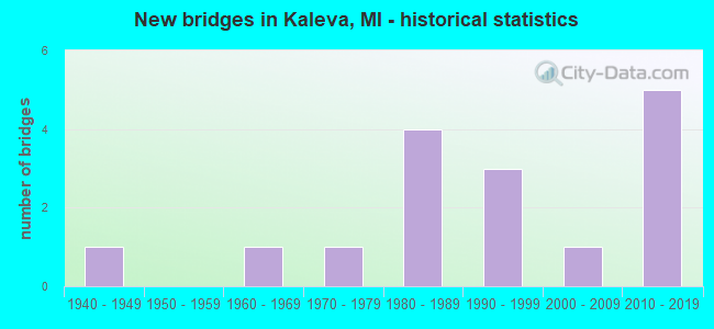
- New bridges - historical statistics
- 11940-1949
- 11960-1969
- 11970-1979
- 41980-1989
- 31990-1999
- 12000-2009
- 52010-2019


- Bridge Condition - Deck
- 8.3%Excellent
- 41.7%Very good
- 33.3%Good
- 16.7%Satisfactory

- Bridge Condition - Superstructure
- 8.3%Excellent
- 33.3%Very good
- 41.7%Good
- 8.3%Satisfactory
- 8.3%Fair

- Bridge Condition - Substructure
- 33.3%Very good
- 33.3%Good
- 25.0%Satisfactory
- 8.3%Fair

- Bridge Condition - Channel
- 13.3%Very good
- 53.3%Good
- 20.0%Satisfactory
- 13.3%Poor

- Bridge Condition - Culverts
- 25.0%Very good
- 50.0%Satisfactory
- 25.0%Fair
Find on map >> Show street view
Structure Number: 1034, Location: 2 MI SW OF WATERVLIET (Lat: 42.171519, Lng: -86.248117), Route carried "on" structure: County highway , Year Built: 1992, Status: Open, Structure Length: 1.22m (4.00ft), Average Daily Traffic: 891 (year 2007), Truck Traffic: 4%, Average Future Daily Traffic: 1,100 (year 2027), Design Load: HS 20, Features Intersected: MILL CREEK, Facility Carried by Structure: DAN SMITH ROAD
Minimum Vertical Clearance: 30.48m (100.00ft), Kilometerpoint: 2.739, Lanes on structure: 2, Owner: County Highway Agency, Approaching Roadway Width: 10.4m (34.1ft), Skew: 3 degrees, Material/Design: Prestressed concrete, Design/Construction: Box Beam or Girders - Multiple, Number Of Spans In Main Unit: 1, Length of Maximum Span: 11.5m (37.7ft), Curb-To-Curb Width: 10.7m (35.1ft), Out-to-Out Width: 11.5m (37.7ft)
Condition: Deck: Very good, Superstructure: Very good, Substructure: Very good, Channel: Good, Operating Rating: 63.2 metric tons, Method Used To Determine Operating Rating: Load Factor (LF) rating reported by rating factor (RF) method using MS18 loading, Inventory Rating: 37.9 metric tons, Method Used To Determine Inventory Rating: Load Factor (LF) rating reported by rating factor (RF) method using MS18 loading, Structural Evaluation: Equal to present desirable criteria, Deck Geometry: Equal to present minimum criteria, Waterway Adequacy: Equal to present desirable criteria, Approach Roadway Alignment: Equal to present desirable criteria, Designated Inspection Frequency: Every 24 months, Inspection Date: July 2020, Deck Structure Type: Concrete Cast-file-Place, Wearing Surface/Protective System: Wearing Surface: Monolithic Concrete, Deck Protection: Epoxy Coated Reinforcing
Find on map >> Show street view
Structure Number: 6453, Location: 1.5 MILES WEST OF KALEVA (Lat: 44.370458, Lng: -86.042278), Route carried "on" structure: County highway 5154, Year Built: 1977, Status: Posted for load, Structure Length: 1.82m (5.97ft), Average Daily Traffic: 2,006 (year 1997), Truck Traffic: 10%, Average Future Daily Traffic: 2,200 (year 2018), Design Load: HS 20+Mod, Features Intersected: BIG BEAR CREEK, Facility Carried by Structure: NINE MILE ROAD
Minimum Vertical Clearance: 30.48m (100.00ft), Kilometerpoint: 11.341, Lanes on structure: 2, Owner: County Highway Agency, Approaching Roadway Width: 9.8m (32.2ft), Material/Design: Prestressed concrete, Design/Construction: Box Beam or Girders - Multiple, Number Of Spans In Main Unit: 1, Length of Maximum Span: 17.3m (56.8ft), Curb-To-Curb Width: 10.4m (34.1ft), Out-to-Out Width: 11.1m (36.4ft)
Condition: Deck: Good, Superstructure: Good, Substructure: Fair, Channel: Good, Operating Rating: 48.9 metric tons, Method Used To Determine Operating Rating: Load Factor (LF) rating reported by rating factor (RF) method using MS18 loading, Inventory Rating: 29.5 metric tons, Method Used To Determine Inventory Rating: Load Factor (LF) rating reported by rating factor (RF) method using MS18 loading, Structural Evaluation: Somewhat better than minimum adequacy, Deck Geometry: Somewhat better than minimum adequacy, Waterway Adequacy: Equal to present minimum criteria, Approach Roadway Alignment: Equal to present desirable criteria, Bridge Posting: Required (Relationship of Operating Rating to Maximum Legal Load: 0.1 - 9.9% below), Designated Inspection Frequency: Every 24 months, Inspection Date: May 2020, Deck Structure Type: Concrete Precast Panels, Wearing Surface/Protective System: Wearing Surface: Bituminous
Find on map >> Show street view
Structure Number: 6455, Location: 5.0 MILES E OF BEAR LAKE (Lat: 44.428242, Lng: -86.045319), Route carried "on" structure: County highway 5178, Year Built: 2013, Status: Open, Structure Length: 1.52m (4.99ft), Average Daily Traffic: 1,841 (year 2012), Truck Traffic: 10%, Average Future Daily Traffic: 2,000 (year 2032), Design Load: Greater than HL93, Features Intersected: BIG BEAR CREEK, Facility Carried by Structure: THIRTEEN MILE ROAD
Minimum Vertical Clearance: 30.48m (100.00ft), Kilometerpoint: 6.735, Lanes on structure: 2, Owner: County Highway Agency, Approaching Roadway Width: 9.8m (32.2ft), Material/Design: Prestressed concrete, Design/Construction: Box Beam or Girders - Multiple, Number Of Spans In Main Unit: 1, Length of Maximum Span: 14.8m (48.6ft), Curb-To-Curb Width: 9.8m (32.2ft), Out-to-Out Width: 10.7m (35.1ft)
Condition: Deck: Very good, Superstructure: Very good, Substructure: Very good, Channel: Good, Operating Rating: 73.5 metric tons, Method Used To Determine Operating Rating: Load and Resistance Factor Rating (LRFR) rating reported by rating factor(RF) method using HL-93 loadings, Inventory Rating: 56.7 metric tons, Method Used To Determine Inventory Rating: Load and Resistance Factor Rating (LRFR) rating reported by rating factor(RF) method using HL-93 loadings, Structural Evaluation: Equal to present desirable criteria, Deck Geometry: Somewhat better than minimum adequacy, Waterway Adequacy: Better than present minimum criteria, Approach Roadway Alignment: Equal to present minimum criteria, Designated Inspection Frequency: Every 24 months, Inspection Date: May 2020, Deck Structure Type: Concrete Cast-file-Place, Wearing Surface/Protective System: Wearing Surface: Monolithic Concrete, Deck Protection: Epoxy Coated Reinforcing
Find on map >> Show street view
Structure Number: 6461, Location: 5.5 MILES EAST OF US 31 (Lat: 44.356217, Lng: -86.049611), Route carried "on" structure: County highway , Year Built: 2006, Status: Open, Structure Length: 0.98m (3.22ft), Average Daily Traffic: 250 (year 2006), Truck Traffic: 2%, Average Future Daily Traffic: 300 (year 2018), Design Load: HS 20+Mod, Features Intersected: BIG BEAR CREEK, Facility Carried by Structure: MILKS ROAD
Minimum Vertical Clearance: 30.48m (100.00ft), Kilometerpoint: 0.452, Lanes on structure: 2, Owner: County Highway Agency, Approaching Roadway Width: 11.0m (36.1ft), Skew: 1 degrees, Material/Design: Wood or Timber, Design/Construction: Slab, Number Of Spans In Main Unit: 1, Length of Maximum Span: 9.4m (30.8ft), Curb-To-Curb Width: 8.5m (27.9ft), Out-to-Out Width: 8.9m (29.2ft)
Condition: Deck: Very good, Superstructure: Very good, Substructure: Good, Channel: Good, Operating Rating: 48.9 metric tons, Method Used To Determine Operating Rating: Allowable Stress (AS) rating reported by rating factor (RF) method using MS18 loading, Inventory Rating: 33.7 metric tons, Method Used To Determine Inventory Rating: Allowable Stress (AS) rating reported by rating factor (RF) method using MS18 loading, Structural Evaluation: Better than present minimum criteria, Deck Geometry: Equal to present minimum criteria, Waterway Adequacy: Equal to present minimum criteria, Approach Roadway Alignment: Better than present minimum criteria, Designated Inspection Frequency: Every 24 months, Inspection Date: May 2020, Deck Structure Type: Wood or Timber, Wearing Surface/Protective System: Wearing Surface: Bituminous
Find on map >> Show street view
Structure Number: 6462, Location: 4 MI NW OF KALEVA (Lat: 44.399192, Lng: -86.048567), Route carried "on" structure: County highway , Year Built: 1987, Status: Open, Structure Length: 1.22m (4.00ft), Average Daily Traffic: 50 (year 1993), Truck Traffic: 4%, Average Future Daily Traffic: 70 (year 2018), Design Load: HS 20+Mod, Features Intersected: BIG BEAR CREEK, Facility Carried by Structure: 11 MILE ROAD
Minimum Vertical Clearance: 30.48m (100.00ft), Kilometerpoint: 16.018, Lanes on structure: 2, Owner: County Highway Agency, Approaching Roadway Width: 10.4m (34.1ft), Material/Design: Wood or Timber, Design/Construction: Slab, Number Of Spans In Main Unit: 2, Length of Maximum Span: 6.1m (20.0ft), Curb-To-Curb Width: 9.8m (32.2ft), Out-to-Out Width: 10.4m (34.1ft)
Condition: Deck: Good, Superstructure: Good, Substructure: Satisfactory, Channel: Good, Operating Rating: 63.8 metric tons, Method Used To Determine Operating Rating: Allowable Stress (AS) rating reported by rating factor (RF) method using MS18 loading, Inventory Rating: 45.4 metric tons, Method Used To Determine Inventory Rating: Allowable Stress (AS) rating reported by rating factor (RF) method using MS18 loading, Structural Evaluation: Equal to present minimum criteria, Deck Geometry: Equal to present desirable criteria, Waterway Adequacy: Better than present minimum criteria, Approach Roadway Alignment: Better than present minimum criteria, Designated Inspection Frequency: Every 24 months, Inspection Date: May 2020, Deck Structure Type: Wood or Timber, Wearing Surface/Protective System: Wearing Surface: Bituminous
Find on map >> Show street view
Structure Number: 6463, Location: 5 MILES EAST OF BEAR LK (Lat: 44.413517, Lng: -86.049394), Route carried "on" structure: County highway , Year Built: 1966, Status: Open, Structure Length: 0.91m (2.99ft), Average Daily Traffic: 200 (year 1993), Truck Traffic: 2%, Average Future Daily Traffic: 250 (year 2018), Design Load: HS 20+Mod, Features Intersected: BIG BEAR CREEK, Facility Carried by Structure: POTTER ROAD
Minimum Vertical Clearance: 30.48m (100.00ft), Kilometerpoint: 4.040, Lanes on structure: 2, Owner: County Highway Agency, Approaching Roadway Width: 9.1m (29.9ft), Material/Design: Steel, Design/Construction: Culvert, Number Of Spans In Main Unit: 2, Length of Maximum Span: 3.6m (11.8ft)
Condition: Channel: Poor, Culverts: Fair, Operating Rating: 97.2 metric tons, Method Used To Determine Operating Rating: Load Factor (LF) rating reported by rating factor (RF) method using MS18 loading, Inventory Rating: 79.4 metric tons, Method Used To Determine Inventory Rating: Load Factor (LF) rating reported by rating factor (RF) method using MS18 loading, Structural Evaluation: Somewhat better than minimum adequacy, Waterway Adequacy: Equal to present minimum criteria, Approach Roadway Alignment: Equal to present minimum criteria, Designated Inspection Frequency: Every 24 months, Inspection Date: May 2020
Find on map >> Show street view
Structure Number: 10016, Location: 0.2 MI NE OF I-69 (Lat: 42.979733, Lng: -82.475772), Route carried "on" structure: Interstate 94, Year Built: 2013, Status: Open, Structure Length: 5.00m (16.40ft), Average Daily Traffic: 13,295 (year 2013), Truck Traffic: 12%, Average Future Daily Traffic: 15,788 (year 2032), Design Load: Greater than HL93, Features Intersected: LAPEER RD
Minimum Vertical Clearance: 30.48m (100.00ft), Kilometerpoint: 36.244, Lanes on structure: 2, Lanes under structure: 2, Base Highway Network: Yes (Inventory Route: 96, Subroute: 4), Owner: State Highway Agency, Approaching Roadway Width: 15.7m (51.5ft), Material/Design: Prestressed concrete, Design/Construction: Box Beam or Girders - Multiple, Number Of Spans In Main Unit: 3, Length of Maximum Span: 28.7m (94.2ft), Curb-To-Curb Width: 17.9m (58.7ft), Out-to-Out Width: 18.6m (61.0ft)
Condition: Deck: Very good, Superstructure: Very good, Substructure: Very good, Operating Rating: 70.6 metric tons, Method Used To Determine Operating Rating: Load and Resistance Factor Rating (LRFR) rating reported by rating factor(RF) method using HL-93 loadings, Inventory Rating: 51.5 metric tons, Method Used To Determine Inventory Rating: Load and Resistance Factor Rating (LRFR) rating reported by rating factor(RF) method using HL-93 loadings, Structural Evaluation: Equal to present desirable criteria, Deck Geometry: Superior to present desirable criteria, Underclear: High priority of corrective action, Approach Roadway Alignment: Better than present minimum criteria, Designated Inspection Frequency: Every 24 months, Inspection Date: September 2021, Deck Structure Type: Concrete Cast-file-Place, Wearing Surface/Protective System: Wearing Surface: Epoxy Overlay, Deck Protection: Epoxy Coated Reinforcing
Find on map >> Show street view
Structure Number: 10029, Location: SEC 36 CLAY TWP (Lat: 42.651317, Lng: -82.623758), Route carried "on" structure: County highway , Year Built: 1984, Year Reconstructed: 2019, Status: Open, Structure Length: 1.74m (5.71ft), Average Daily Traffic: 1,655 (year 1994), Truck Traffic: 3%, Average Future Daily Traffic: 1,700 (year 2014), Design Load: Greater than HL93, Features Intersected: UNNAMED CANAL, Facility Carried by Structure: ANCHOR BAY DRIVE
Minimum Vertical Clearance: 30.48m (100.00ft), Kilometerpoint: 0.595, Lanes on structure: 2, Owner: County Highway Agency, Approaching Roadway Width: 6.1m (20.0ft), Material/Design: Steel, Design/Construction: Stringer/Multi-beam, Number Of Spans In Main Unit: 1, Length of Maximum Span: 16.6m (54.5ft), Curb-To-Curb Width: 8.2m (26.9ft), Out-to-Out Width: 8.3m (27.2ft)
Condition: Deck: Excellent, Superstructure: Excellent, Substructure: Very good, Channel: Good, Operating Rating: 69.3 metric tons, Method Used To Determine Operating Rating: Load and Resistance Factor Rating (LRFR) rating reported by rating factor(RF) method using HL-93 loadings, Inventory Rating: 53.5 metric tons, Method Used To Determine Inventory Rating: Load and Resistance Factor Rating (LRFR) rating reported by rating factor(RF) method using HL-93 loadings, Structural Evaluation: Equal to present desirable criteria, Deck Geometry: Meets minimum limits, Waterway Adequacy: Better than present minimum criteria, Approach Roadway Alignment: Somewhat better than minimum adequacy, Length Of Structure Improvement: 2.29m (7.51ft), Designated Inspection Frequency: Every 24 months, Underwater Inspection Frequency: Every 60 months, Inspection Date: April 2020, Underwater Inspection Date: October 2017, Roadway Improvement Cost: $10,000, Total Project Cost: $12,000, Deck Structure Type: Concrete Precast Panels, Wearing Surface/Protective System: Wearing Surface: Epoxy Overlay, Deck Protection: Epoxy Coated Reinforcing
Find on map >> Show street view
Structure Number: 10174, Location: SEC. 26 GREENWOOD TWP. (Lat: 43.098194, Lng: -82.662239), Route carried "on" structure: ServiceCounty highway , Year Built: 1996, Status: Open, Structure Length: 0.98m (3.22ft), Average Daily Traffic: 106 (year 1994), Average Future Daily Traffic: 150 (year 2015), Design Load: HS 20+Mod, Features Intersected: PLUM CREEK DRAIN, Facility Carried by Structure: HEWITT ROAD
Minimum Vertical Clearance: 30.48m (100.00ft), Kilometerpoint: 1.299, Lanes on structure: 2, Owner: County Highway Agency, Approaching Roadway Width: 6.7m (22.0ft), Material/Design: Prestressed concrete, Design/Construction: Box Beam or Girders - Multiple, Number Of Spans In Main Unit: 1, Length of Maximum Span: 9.4m (30.8ft), Curb-To-Curb Width: 9.7m (31.8ft), Out-to-Out Width: 10.4m (34.1ft)
Condition: Deck: Very good, Superstructure: Good, Substructure: Good, Channel: Satisfactory, Operating Rating: 73.9 metric tons, Method Used To Determine Operating Rating: Load Factor (LF) rating reported by rating factor (RF) method using MS18 loading, Inventory Rating: 44.1 metric tons, Method Used To Determine Inventory Rating: Load Factor (LF) rating reported by rating factor (RF) method using MS18 loading, Structural Evaluation: Better than present minimum criteria, Deck Geometry: Equal to present minimum criteria, Waterway Adequacy: Better than present minimum criteria, Approach Roadway Alignment: Equal to present desirable criteria, Designated Inspection Frequency: Every 24 months, Inspection Date: Febuary 2021, Deck Structure Type: Concrete Cast-file-Place, Wearing Surface/Protective System: Wearing Surface: Bituminous
Find on map >> Show street view
Structure Number: 10176, Location: SEC. 15-16 GREENWOOD TWP (Lat: 43.130436, Lng: -82.700161), Route carried "on" structure: ServiceCounty highway , Year Built: 2019, Status: Open, Structure Length: 1.23m (4.04ft), Average Daily Traffic: 82 (year 1994), Average Future Daily Traffic: 152 (year 2014), Design Load: Greater than HL93, Features Intersected: EVES DRAIN, Facility Carried by Structure: KILGORE ROAD
Minimum Vertical Clearance: 30.48m (100.00ft), Kilometerpoint: 16.916, Lanes on structure: 2, Owner: County Highway Agency, Approaching Roadway Width: 6.1m (20.0ft), Material/Design: Aluminum, Iron, Design/Construction: Culvert, Number Of Spans In Main Unit: 1, Length of Maximum Span: 7.7m (25.3ft), Curb-To-Curb Width: 9.1m (29.9ft), Out-to-Out Width: 12.3m (40.4ft)
Condition: Channel: Good, Culverts: Very good, Operating Rating: 52.2 metric tons, Method Used To Determine Operating Rating: Load and Resistance Factor Rating (LRFR) rating reported by rating factor(RF) method using HL-93 loadings, Inventory Rating: 43.4 metric tons, Method Used To Determine Inventory Rating: Load and Resistance Factor Rating (LRFR) rating reported by rating factor(RF) method using HL-93 loadings, Structural Evaluation: Equal to present desirable criteria, Deck Geometry: Better than present minimum criteria, Waterway Adequacy: Equal to present desirable criteria, Approach Roadway Alignment: Equal to present desirable criteria, Length Of Structure Improvement: 9.15m (30.02ft), Designated Inspection Frequency: Every 24 months, Inspection Date: October 2021, Roadway Improvement Cost: $13,000, Total Project Cost: $15,000, Wearing Surface/Protective System: Wearing Surface: Bituminous
Find on map >> Show street view
Structure Number: 10177, Location: SEC. 26-27 GREENWOOD TWP. (Lat: 43.095103, Lng: -82.678019), Route carried "on" structure: ServiceCounty highway , Year Built: 1983, Status: Open, Structure Length: 0.67m (2.20ft), Average Daily Traffic: 67 (year 1994), Average Future Daily Traffic: 105 (year 2014), Design Load: HS 20, Features Intersected: PLUM CREEK DRAIN, Facility Carried by Structure: DUCE ROAD
Minimum Vertical Clearance: 30.48m (100.00ft), Kilometerpoint: 5.118, Lanes on structure: 2, Owner: County Highway Agency, Approaching Roadway Width: 6.1m (20.0ft), Material/Design: Prestressed concrete, Design/Construction: Tee Beam, Number Of Spans In Main Unit: 1, Length of Maximum Span: 5.7m (18.7ft), Curb-To-Curb Width: 6.0m (19.7ft), Out-to-Out Width: 6.1m (20.0ft)
Condition: Deck: Satisfactory, Superstructure: Fair, Substructure: Satisfactory, Channel: Satisfactory, Operating Rating: 83.9 metric tons, Method Used To Determine Operating Rating: Load Factor (LF) rating reported by rating factor (RF) method using MS18 loading, Inventory Rating: 50.2 metric tons, Method Used To Determine Inventory Rating: Load Factor (LF) rating reported by rating factor (RF) method using MS18 loading, Structural Evaluation: Somewhat better than minimum adequacy, Deck Geometry: Meets minimum limits, Waterway Adequacy: Better than present minimum criteria, Approach Roadway Alignment: Equal to present desirable criteria, Length Of Structure Improvement: 2.29m (7.51ft), Designated Inspection Frequency: Every 24 months, Inspection Date: Febuary 2021, Roadway Improvement Cost: $9,000, Total Project Cost: $10,000, Deck Structure Type: Concrete Cast-file-Place, Wearing Surface/Protective System: Wearing Surface: Bituminous, Deck Protection: Epoxy Coated Reinforcing
Find on map >> Show street view
Structure Number: 10238, Location: SEC. 2 WALES TWP. (Lat: 42.982964, Lng: -82.658722), Route carried "on" structure: ServiceCounty highway , Year Built: 1994, Status: Posted for load, Structure Length: 1.31m (4.30ft), Average Daily Traffic: 570 (year 2020), Truck Traffic: 3%, Average Future Daily Traffic: 695 (year 2040), Design Load: HS 20+Mod, Features Intersected: SOUTH BR. PINE RIVER, Facility Carried by Structure: COUNTY PARK ROAD
Minimum Vertical Clearance: 30.48m (100.00ft), Kilometerpoint: 0.538, Lanes on structure: 2, Owner: County Highway Agency, Approaching Roadway Width: 9.1m (29.9ft), Skew: 3 degrees, Material/Design: Prestressed concrete, Design/Construction: Tee Beam, Number Of Spans In Main Unit: 1, Length of Maximum Span: 11.7m (38.4ft), Curb-To-Curb Width: 10.4m (34.1ft), Out-to-Out Width: 11.3m (37.1ft)
Condition: Deck: Good, Superstructure: Satisfactory, Substructure: Good, Channel: Very good, Operating Rating: 49.2 metric tons, Method Used To Determine Operating Rating: Load Factor (LF) rating reported by rating factor (RF) method using MS18 loading, Inventory Rating: 30.1 metric tons, Method Used To Determine Inventory Rating: Load Factor (LF) rating reported by rating factor (RF) method using MS18 loading, Structural Evaluation: Equal to present minimum criteria, Deck Geometry: Equal to present minimum criteria, Waterway Adequacy: Better than present minimum criteria, Approach Roadway Alignment: Somewhat better than minimum adequacy, Bridge Posting: Required (Relationship of Operating Rating to Maximum Legal Load: 0.1 - 9.9% below), Designated Inspection Frequency: Every 24 months, Inspection Date: December 2021, Deck Structure Type: Concrete Precast Panels, Wearing Surface/Protective System: Wearing Surface: Bituminous, Membrane: Preformed Fabric
Find on map >> Show street view
Structure Number: 10403, Location: 0.6 MI S OF M-25 (Lat: 43.645086, Lng: -83.466172), Route carried "on" structure: State highway 138, Year Built: 1983, Status: Open, Structure Length: 1.82m (5.97ft), Average Daily Traffic: 1,825 (year 2007), Truck Traffic: 11%, Average Future Daily Traffic: 2,004 (year 2018), Design Load: HS 25 or greater, Features Intersected: WISCOGGIN CREEK, Facility Carried by Structure: M-24
Minimum Vertical Clearance: 30.48m (100.00ft), Kilometerpoint: 11.890, Lanes on structure: 2, Base Highway Network: Yes (Inventory Route: 27, Subroute: 9), Owner: State Highway Agency, Approaching Roadway Width: 12.2m (40.0ft), Material/Design: Prestressed concrete, Design/Construction: Stringer/Multi-beam, Number Of Spans In Main Unit: 1, Length of Maximum Span: 18.2m (59.7ft), Curb-To-Curb Width: 14.6m (47.9ft), Out-to-Out Width: 15.6m (51.2ft)
Condition: Deck: Good, Superstructure: Good, Substructure: Satisfactory, Channel: Good, Operating Rating: 73.2 metric tons, Method Used To Determine Operating Rating: Load Factor (LF) rating reported by rating factor (RF) method using MS18 loading, Inventory Rating: 40.5 metric tons, Method Used To Determine Inventory Rating: Load Factor (LF) rating reported by rating factor (RF) method using MS18 loading, Structural Evaluation: Equal to present minimum criteria, Deck Geometry: Superior to present desirable criteria, Waterway Adequacy: Equal to present desirable criteria, Approach Roadway Alignment: Better than present minimum criteria, Designated Inspection Frequency: Every 24 months, Inspection Date: June 2020, Deck Structure Type: Concrete Cast-file-Place, Wearing Surface/Protective System: Wearing Surface: Epoxy Overlay, Deck Protection: Epoxy Coated Reinforcing
Find on map >> Show street view
Structure Number: 10431, Location: 2.5 MI NW OF MAYVILLE LTS (Lat: 43.365708, Lng: -83.382950), Route carried "on" structure: State highway 24, Year Built: 1941, Status: Open, Structure Length: 0.72m (2.36ft), Average Daily Traffic: 4,188 (year 2007), Truck Traffic: 11%, Average Future Daily Traffic: 5,175 (year 2018), Features Intersected: KREGER DRAIN
Minimum Vertical Clearance: 30.48m (100.00ft), Kilometerpoint: 8.567, Lanes on structure: 2, Base Highway Network: Yes (Inventory Route: 27, Subroute: 5), Owner: State Highway Agency, Approaching Roadway Width: 10.9m (35.8ft), Skew: 3 degrees, Material/Design: Concrete, Design/Construction: Culvert, Number Of Spans In Main Unit: 2, Length of Maximum Span: 3.4m (11.2ft), Out-to-Out Width: 35.1m (115.2ft)
Condition: Channel: Poor, Culverts: Satisfactory, Operating Rating: 54.5 metric tons, Method Used To Determine Operating Rating: Field evaluation and documented engineering judgment, Inventory Rating: 32.7 metric tons, Method Used To Determine Inventory Rating: Field evaluation and documented engineering judgment, Structural Evaluation: Equal to present minimum criteria, Waterway Adequacy: Equal to present minimum criteria, Approach Roadway Alignment: Equal to present desirable criteria, Designated Inspection Frequency: Every 24 months, Inspection Date: March 2022, Wearing Surface/Protective System: Wearing Surface: Bituminous
Find on map >> Show street view
Structure Number: 10439, Location: 0.8 MI E OF BAY CO LINE (Lat: 43.581211, Lng: -83.683817), Route carried "on" structure: State highway 25, Year Built: 2013, Status: Open, Structure Length: 7.32m (24.02ft), Average Daily Traffic: 5,571 (year 2012), Truck Traffic: 6%, Average Future Daily Traffic: 7,535 (year 2032), Design Load: Greater than HL93, Features Intersected: QUANICASSEE RIVER
Minimum Vertical Clearance: 30.48m (100.00ft), Kilometerpoint: 1.308, Lanes on structure: 2, Base Highway Network: Yes (Inventory Route: 27, Subroute: 3), Owner: State Highway Agency, Approaching Roadway Width: 13.4m (44.0ft), Skew: 3 degrees, Material/Design: Prestressed concrete, Design/Construction: Box Beam or Girders - Single/Spread, Number Of Spans In Main Unit: 3, Length of Maximum Span: 23.7m (77.8ft), Curb-To-Curb Width: 13.4m (44.0ft), Out-to-Out Width: 14.4m (47.2ft)
Condition: Deck: Satisfactory, Superstructure: Good, Substructure: Good, Channel: Very good, Operating Rating: 61.2 metric tons, Method Used To Determine Operating Rating: Load and Resistance Factor Rating (LRFR) rating reported by rating factor(RF) method using HL-93 loadings, Inventory Rating: 38.6 metric tons, Method Used To Determine Inventory Rating: Load and Resistance Factor Rating (LRFR) rating reported by rating factor(RF) method using HL-93 loadings, Structural Evaluation: Better than present minimum criteria, Deck Geometry: Equal to present minimum criteria, Waterway Adequacy: Equal to present desirable criteria, Approach Roadway Alignment: Equal to present minimum criteria, Designated Inspection Frequency: Every 24 months, Underwater Inspection Frequency: Every 60 months, Inspection Date: June 2021, Underwater Inspection Date: July 2020, Deck Structure Type: Concrete Cast-file-Place, Wearing Surface/Protective System: Wearing Surface: Monolithic Concrete, Deck Protection: Epoxy Coated Reinforcing
Find on map >> Show street view
Structure Number: 13617, Location: 6.28 MI E OF US-31 (Lat: 44.374722, Lng: -86.035278), Route carried "on" structure: County highway , Year Built: 2010, Status: Open, Structure Length: 0.94m (3.08ft), Average Daily Traffic: 300 (year 1993), Truck Traffic: 2%, Average Future Daily Traffic: 320 (year 2018), Design Load: HS 20, Features Intersected: KALEVA CREEK, Facility Carried by Structure: JOHNSON ROAD
Minimum Vertical Clearance: 30.48m (100.00ft), Kilometerpoint: 6.129, Lanes on structure: 2, Owner: County Highway Agency, Approaching Roadway Width: 9.3m (30.5ft), Material/Design: Aluminum, Iron, Design/Construction: Culvert, Number Of Spans In Main Unit: 1, Length of Maximum Span: 9.4m (30.8ft)
Condition: Channel: Satisfactory, Culverts: Satisfactory, Operating Rating: 75.2 metric tons, Method Used To Determine Operating Rating: Load and Resistance Factor Rating (LRFR) rating reported by rating factor(RF) method using HL-93 loadings, Inventory Rating: 58.0 metric tons, Method Used To Determine Inventory Rating: Load and Resistance Factor Rating (LRFR) rating reported by rating factor(RF) method using HL-93 loadings, Structural Evaluation: Equal to present minimum criteria, Waterway Adequacy: Equal to present desirable criteria, Approach Roadway Alignment: Equal to present desirable criteria, Designated Inspection Frequency: Every 24 months, Inspection Date: May 2020, Wearing Surface/Protective System: Wearing Surface: Bituminous