Bridge Statistics for Johnstown, Colorado (CO)
Condition, Traffic, Stress, Structural Evaluation, Project Costs
- National Bridge Inventory (NBI) Statistics
- 33Number of bridges
- 295ft / 90.0mTotal length
- $206,000Total costs
- 809,256Total average daily traffic
- 94,890Total average daily truck traffic
- National Bridge Inventory (NBI) Registered Bridges for Johnstown
- No street view available for this location
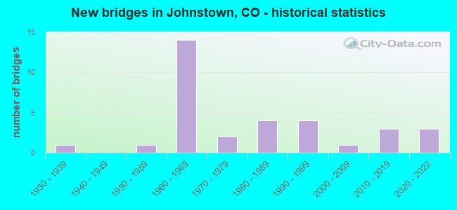
- New bridges - historical statistics
- 11930-1939
- 11950-1959
- 141960-1969
- 21970-1979
- 41980-1989
- 41990-1999
- 12000-2009
- 32010-2019
- 32020-2022
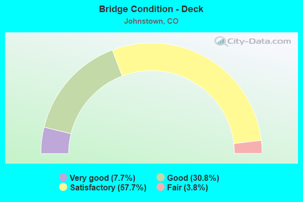
- Bridge Condition - Deck
- 7.7%Very good
- 30.8%Good
- 57.7%Satisfactory
- 3.8%Fair
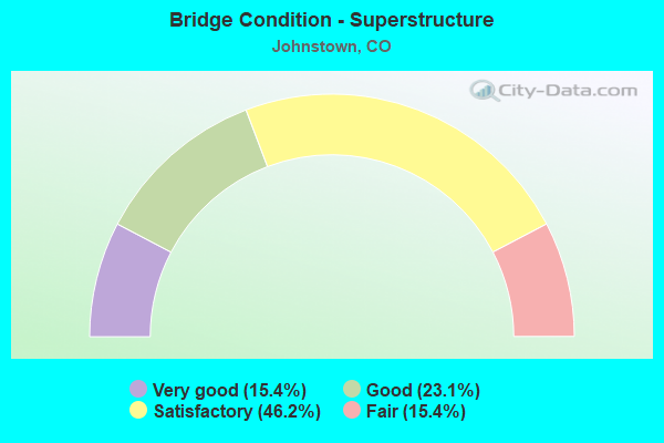
- Bridge Condition - Superstructure
- 15.4%Very good
- 23.1%Good
- 46.2%Satisfactory
- 15.4%Fair
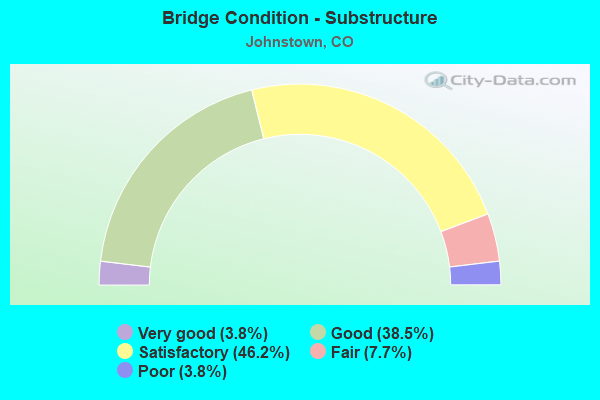
- Bridge Condition - Substructure
- 3.8%Very good
- 38.5%Good
- 46.2%Satisfactory
- 7.7%Fair
- 3.8%Poor
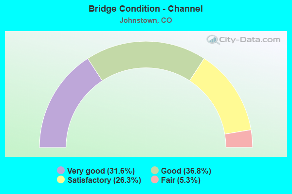
- Bridge Condition - Channel
- 31.6%Very good
- 36.8%Good
- 26.3%Satisfactory
- 5.3%Fair
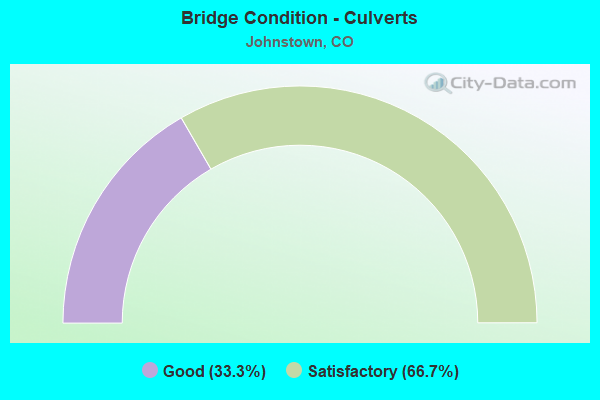
- Bridge Condition - Culverts
- 33.3%Good
- 66.7%Satisfactory
Find on map >> Show street view
Structure Number: C-17-AI, Location: 4 MI NO OF JCT SH 66 (Lat: 40.262622, Lng: -104.980694), Route carried "on" structure: County highway , Year Built: 1960, Status: Open, Structure Length: 6.86m (22.51ft), Average Daily Traffic: 652 (year 2020), Truck Traffic: 10%, Average Future Daily Traffic: 1,930 (year 2028), Design Load: HS 20, Features Intersected: I 25 ML, Facility Carried by Structure: COUNTY ROAD 38
Minimum Vertical Clearance: 30+ m (98+ ft), Kilometerpoint: 1.525, Lanes on structure: 2, Lanes under structure: 5, Owner: State Highway Agency, Approaching Roadway Width: 9.1m (29.9ft), Material/Design: Concrete continuous, Design/Construction: Tee Beam, Number Of Spans In Main Unit: 4, Length of Maximum Span: 20.0m (65.6ft), Curb-To-Curb Width: 8.5m (27.9ft), Out-to-Out Width: 9.8m (32.2ft)
Condition: Deck: Good, Superstructure: Satisfactory, Substructure: Satisfactory, Operating Rating: 64.5 metric tons, Method Used To Determine Operating Rating: Load Factor (LF), Inventory Rating: 38.6 metric tons, Method Used To Determine Inventory Rating: Load Factor (LF), Structural Evaluation: Equal to present minimum criteria, Deck Geometry: Somewhat better than minimum adequacy, Underclear: Meets minimum limits, Approach Roadway Alignment: Equal to present desirable criteria, Designated Inspection Frequency: Every 24 months, Inspection Date: June 2021, Deck Structure Type: Concrete Cast-file-Place, Wearing Surface/Protective System: Wearing Surface: Bituminous, Membrane: Built-up
Find on map >> Show street view
Structure Number: C-17-AJ, Location: 4.9 MI E OF JCT US 287 (Lat: 40.306267, Lng: -104.981419), Route carried "on" structure: State highway 56B, Year Built: 1961, Status: Open, Structure Length: 6.80m (22.31ft), Average Daily Traffic: 7,000 (year 2020), Truck Traffic: 7%, Average Future Daily Traffic: 10,710 (year 2040), Design Load: H 20, Features Intersected: I 25 ML, Facility Carried by Structure: SH 56 ML
Minimum Vertical Clearance: 30+ m (98+ ft), Kilometerpoint: 10.618, Lanes on structure: 2, Lanes under structure: 4, Owner: State Highway Agency, Approaching Roadway Width: 12.2m (40.0ft), Material/Design: Concrete continuous, Design/Construction: Tee Beam, Number Of Spans In Main Unit: 4, Length of Maximum Span: 20.0m (65.6ft), Curb-To-Curb Width: 9.1m (29.9ft), Out-to-Out Width: 10.4m (34.1ft)
Condition: Deck: Satisfactory, Superstructure: Satisfactory, Substructure: Satisfactory, Operating Rating: 68.9 metric tons, Method Used To Determine Operating Rating: Load Factor (LF), Inventory Rating: 41.2 metric tons, Method Used To Determine Inventory Rating: Load Factor (LF), Structural Evaluation: Equal to present minimum criteria, Deck Geometry: Meets minimum limits, Underclear: Meets minimum limits, Approach Roadway Alignment: Equal to present desirable criteria, Designated Inspection Frequency: Every 24 months, Inspection Date: June 2021, Deck Structure Type: Concrete Cast-file-Place, Wearing Surface/Protective System: Wearing Surface: Bituminous, Membrane: Built-up
Find on map >> Show street view
Structure Number: C-17-BA, Location: IN JOHNSTOWN (Lat: 40.334686, Lng: -104.911008), Route carried "on" structure: State highway 60B, Year Built: 1957, Status: Open, Structure Length: 0.72m (2.36ft), Average Daily Traffic: 11,000 (year 2020), Truck Traffic: 4%, Average Future Daily Traffic: 16,060 (year 2040), Design Load: H 20, Features Intersected: HILLSBORO DITCH, Facility Carried by Structure: SH 60 ML
Minimum Vertical Clearance: 30+ m (98+ ft), Kilometerpoint: 5.955, Lanes on structure: 2, Owner: State Highway Agency, Approaching Roadway Width: 12.8m (42.0ft), Skew: 4 degrees, Material/Design: Concrete, Design/Construction: Culvert, Number Of Spans In Main Unit: 1, Length of Maximum Span: 7.2m (23.6ft), Curb or Sidewalk Widths: Left: 0.5m (1.6ft), Right: 0.5m (1.6ft), Curb-To-Curb Width: 13.6m (44.6ft), Out-to-Out Width: 14.6m (47.9ft)
Condition: Channel: Good, Culverts: Satisfactory, Operating Rating: 36.3 metric tons, Method Used To Determine Operating Rating: Field evaluation and documented engineering judgment, Inventory Rating: 32.7 metric tons, Method Used To Determine Inventory Rating: Field evaluation and documented engineering judgment, Structural Evaluation: Equal to present minimum criteria, Deck Geometry: Superior to present desirable criteria, Waterway Adequacy: Equal to present desirable criteria, Approach Roadway Alignment: Equal to present desirable criteria, Designated Inspection Frequency: Every 24 months, Inspection Date: December 2021
Find on map >> Show street view
Structure Number: C-17-BB, Location: AT JCT I 25 (Lat: 40.335556, Lng: -104.980556), Route carried "on" structure: State highway 60B, Year Built: 1962, Status: Closed, Structure Length: 6.34m (20.80ft), Average Daily Traffic: 12,000 (year 2020), Truck Traffic: 4%, Average Future Daily Traffic: 18,720 (year 2040), Design Load: HS 20, Features Intersected: I 25 ML, Facility Carried by Structure: SH 60 ML
Minimum Vertical Clearance: 30+ m (98+ ft), Kilometerpoint: 0.039, Lanes on structure: 2, Lanes under structure: 4, Owner: State Highway Agency, Approaching Roadway Width: 10.7m (35.1ft), Material/Design: Concrete continuous, Design/Construction: Tee Beam, Number Of Spans In Main Unit: 4, Length of Maximum Span: 20.1m (65.9ft), Curb-To-Curb Width: 8.5m (27.9ft), Out-to-Out Width: 9.8m (32.2ft)
Condition: Deck: Satisfactory, Superstructure: Satisfactory, Substructure: Good, Operating Rating: 54.7 metric tons, Method Used To Determine Operating Rating: Load Factor (LF), Inventory Rating: 32.8 metric tons, Method Used To Determine Inventory Rating: Load Factor (LF), Structural Evaluation: Equal to present minimum criteria, Deck Geometry: Meets minimum limits, Underclear: Meets minimum limits, Approach Roadway Alignment: Equal to present desirable criteria, Designated Inspection Frequency: Every 24 months, Inspection Date: December 2021, Deck Structure Type: Concrete Cast-file-Place, Wearing Surface/Protective System: Wearing Surface: Bituminous, Membrane: Built-up
Find on map >> Show street view
Structure Number: C-17-BQ, Location: 0.9 MI NO OF JCT SH 60 EA (Lat: 40.349042, Lng: -104.980844), Route carried "on" structure: Interstate 25A, Year Built: 1962, Status: Open, Structure Length: 3.32m (10.89ft), Average Daily Traffic: 36,500 (year 2020), Truck Traffic: 10%, Average Future Daily Traffic: 54,020 (year 2040), Design Load: HS 20, Features Intersected: SH 60 ML, Facility Carried by Structure: I 25 ML NBND
Minimum Vertical Clearance: 30+ m (98+ ft), Kilometerpoint: 407.095, Lanes on structure: 2, Lanes under structure: 2, Base Highway Network: Yes, Owner: State Highway Agency, Approaching Roadway Width: 11.6m (38.1ft), Skew: 10 degrees, Material/Design: Concrete continuous, Design/Construction: Tee Beam, Number Of Spans In Main Unit: 3, Length of Maximum Span: 13.1m (43.0ft), Curb-To-Curb Width: 11.6m (38.1ft), Out-to-Out Width: 12.8m (42.0ft)
Condition: Deck: Satisfactory, Superstructure: Satisfactory, Substructure: Satisfactory, Operating Rating: 52.9 metric tons, Method Used To Determine Operating Rating: Load Factor (LF), Inventory Rating: 31.8 metric tons, Method Used To Determine Inventory Rating: Load Factor (LF), Structural Evaluation: Equal to present minimum criteria, Deck Geometry: Equal to present minimum criteria, Underclear: Meets minimum limits, Approach Roadway Alignment: Equal to present desirable criteria, Designated Inspection Frequency: Every 24 months, Inspection Date: June 2021, Deck Structure Type: Concrete Cast-file-Place, Wearing Surface/Protective System: Wearing Surface: Other, Membrane: Other
Find on map >> Show street view
Structure Number: C-17-BR, Location: 2.1 MI SO OF JCT SH 402 (Lat: 40.349039, Lng: -104.981167), Route carried "on" structure: Interstate 25A, Year Built: 1962, Status: Open, Structure Length: 3.32m (10.89ft), Average Daily Traffic: 36,500 (year 2020), Truck Traffic: 10%, Average Future Daily Traffic: 54,020 (year 2040), Design Load: HS 20, Features Intersected: SH 60 ML, Facility Carried by Structure: I 25 ML SBND
Minimum Vertical Clearance: 30+ m (98+ ft), Kilometerpoint: 407.098, Lanes on structure: 2, Lanes under structure: 2, Base Highway Network: Yes, Owner: State Highway Agency, Approaching Roadway Width: 11.6m (38.1ft), Skew: 10 degrees, Material/Design: Concrete continuous, Design/Construction: Tee Beam, Number Of Spans In Main Unit: 3, Length of Maximum Span: 13.1m (43.0ft), Curb-To-Curb Width: 11.6m (38.1ft), Out-to-Out Width: 12.8m (42.0ft)
Condition: Deck: Satisfactory, Superstructure: Satisfactory, Substructure: Satisfactory, Operating Rating: 51.6 metric tons, Method Used To Determine Operating Rating: Load Factor (LF), Inventory Rating: 30.9 metric tons, Method Used To Determine Inventory Rating: Load Factor (LF), Structural Evaluation: Equal to present minimum criteria, Deck Geometry: Equal to present minimum criteria, Underclear: Meets minimum limits, Approach Roadway Alignment: Equal to present desirable criteria, Designated Inspection Frequency: Every 24 months, Inspection Date: June 2021, Deck Structure Type: Concrete Cast-file-Place, Wearing Surface/Protective System: Wearing Surface: Other, Membrane: Other
Find on map >> Show street view
Structure Number: C-17-CE, Location: 1.5 MI NO OF JCT SH 56 WE (Lat: 40.328097, Lng: -104.979958), Route carried "on" structure: Interstate 25A, Year Built: 1961, Status: Open, Structure Length: 2.48m (8.14ft), Average Daily Traffic: 36,000 (year 2020), Truck Traffic: 10%, Average Future Daily Traffic: 52,200 (year 2040), Design Load: HL 93, Features Intersected: GW RR, Facility Carried by Structure: I 25 ML NBND
Minimum Vertical Clearance: 30+ m (98+ ft), Kilometerpoint: 404.774, Lanes on structure: 2, Base Highway Network: Yes, Owner: State Highway Agency, Approaching Roadway Width: 11.6m (38.1ft), Skew: 10 degrees, Material/Design: Concrete, Design/Construction: Tee Beam, Number Of Spans In Main Unit: 3, Length of Maximum Span: 7.9m (25.9ft), Curb-To-Curb Width: 11.6m (38.1ft), Out-to-Out Width: 12.8m (42.0ft)
Condition: Deck: Satisfactory, Superstructure: Satisfactory, Substructure: Fair, Operating Rating: 42.1 metric tons, Method Used To Determine Operating Rating: Load and Resistance Factor Rating (LRFR) rating reported by rating factor(RF) method using HL-93 loadings, Inventory Rating: 32.4 metric tons, Method Used To Determine Inventory Rating: Load and Resistance Factor Rating (LRFR) rating reported by rating factor(RF) method using HL-93 loadings, Structural Evaluation: Somewhat better than minimum adequacy, Deck Geometry: Equal to present minimum criteria, Underclear: High priority of corrective action, Approach Roadway Alignment: Equal to present desirable criteria, Designated Inspection Frequency: Every 24 months, Inspection Date: June 2021, Deck Structure Type: Concrete Cast-file-Place, Wearing Surface/Protective System: Wearing Surface: Latex Concrete
Find on map >> Show street view
Structure Number: C-17-D, Location: 2.9 MI E OF JCT I 25 (Lat: 40.406514, Lng: -104.937258), Route carried "on" structure: US 34A, Year Built: 1934, Year Reconstructed: 1975, Status: Open, Structure Length: 1.72m (5.64ft), Average Daily Traffic: 43,000 (year 2020), Truck Traffic: 3%, Average Future Daily Traffic: 64,930 (year 2040), Design Load: HS 20, Features Intersected: LOVELAND-GREELEY CANAL, Facility Carried by Structure: US 34 ML
Minimum Vertical Clearance: 30+ m (98+ ft), Kilometerpoint: 158.855, Lanes on structure: 4, Base Highway Network: Yes, Owner: State Highway Agency, Approaching Roadway Width: 23.2m (76.1ft), Skew: 26 degrees, Material/Design: Concrete, Design/Construction: Culvert, Number Of Spans In Main Unit: 2, Length of Maximum Span: 8.0m (26.2ft), Out-to-Out Width: 54.3m (178.1ft)
Condition: Channel: Very good, Culverts: Satisfactory, Operating Rating: 36.3 metric tons, Method Used To Determine Operating Rating: Field evaluation and documented engineering judgment, Inventory Rating: 32.7 metric tons, Method Used To Determine Inventory Rating: Field evaluation and documented engineering judgment, Structural Evaluation: Equal to present minimum criteria, Waterway Adequacy: Equal to present desirable criteria, Approach Roadway Alignment: Equal to present desirable criteria, Designated Inspection Frequency: Every 24 months, Inspection Date: November 2021
Find on map >> Show street view
Structure Number: C-17-DH, Location: 1 MI SO OF JCT SH 60 (Lat: 40.320772, Lng: -104.980275), Route carried "on" structure: Interstate 25A, Year Built: 1962, Status: Open, Structure Length: 3.03m (9.94ft), Average Daily Traffic: 36,000 (year 2020), Truck Traffic: 10%, Average Future Daily Traffic: 52,200 (year 2040), Design Load: HS 20, Features Intersected: COUNTY ROAD 46, Facility Carried by Structure: I 25 ML SBND
Minimum Vertical Clearance: 30+ m (98+ ft), Kilometerpoint: 403.957, Lanes on structure: 2, Lanes under structure: 2, Base Highway Network: Yes, Owner: State Highway Agency, Approaching Roadway Width: 11.6m (38.1ft), Skew: 10 degrees, Material/Design: Concrete, Design/Construction: Tee Beam, Number Of Spans In Main Unit: 3, Length of Maximum Span: 9.8m (32.2ft), Curb-To-Curb Width: 11.6m (38.1ft), Out-to-Out Width: 12.8m (42.0ft)
Condition: Deck: Satisfactory, Superstructure: Satisfactory, Substructure: Satisfactory, Operating Rating: 47.2 metric tons, Method Used To Determine Operating Rating: Load Factor (LF), Inventory Rating: 28.3 metric tons, Method Used To Determine Inventory Rating: Load Factor (LF), Structural Evaluation: Equal to present minimum criteria, Deck Geometry: Equal to present minimum criteria, Underclear: High priority of corrective action, Approach Roadway Alignment: Equal to present desirable criteria, Designated Inspection Frequency: Every 24 months, Inspection Date: June 2021, Deck Structure Type: Concrete Cast-file-Place, Wearing Surface/Protective System: Wearing Surface: Other, Membrane: Other
Find on map >> Show street view
Structure Number: C-17-DY, Location: 1 MI NO OF JCT SH 56 (Lat: 40.320767, Lng: -104.979950), Route carried "on" structure: Interstate 25A, Year Built: 1961, Status: Open, Structure Length: 3.03m (9.94ft), Average Daily Traffic: 36,000 (year 2020), Truck Traffic: 10%, Average Future Daily Traffic: 52,200 (year 2040), Design Load: H 20, Features Intersected: COUNTY ROAD 46, Facility Carried by Structure: I 25 ML NBND
Minimum Vertical Clearance: 30+ m (98+ ft), Kilometerpoint: 403.955, Lanes on structure: 2, Lanes under structure: 2, Base Highway Network: Yes, Owner: State Highway Agency, Approaching Roadway Width: 11.6m (38.1ft), Skew: 10 degrees, Material/Design: Concrete, Design/Construction: Tee Beam, Number Of Spans In Main Unit: 3, Length of Maximum Span: 9.8m (32.2ft), Curb-To-Curb Width: 11.6m (38.1ft), Out-to-Out Width: 12.8m (42.0ft)
Condition: Deck: Satisfactory, Superstructure: Satisfactory, Substructure: Satisfactory, Operating Rating: 47.2 metric tons, Method Used To Determine Operating Rating: Load Factor (LF), Inventory Rating: 28.3 metric tons, Method Used To Determine Inventory Rating: Load Factor (LF), Structural Evaluation: Equal to present minimum criteria, Deck Geometry: Equal to present minimum criteria, Underclear: Meets minimum limits, Approach Roadway Alignment: Equal to present desirable criteria, Designated Inspection Frequency: Every 24 months, Inspection Date: June 2021, Deck Structure Type: Concrete Cast-file-Place, Wearing Surface/Protective System: Wearing Surface: Other, Membrane: Other
Find on map >> Show street view
Structure Number: C-17-EI, Location: 1 MI N OF JCT SH 60 (Lat: 40.363519, Lng: -104.985506), Route carried "on" structure: Interstate 25A, Year Built: 1962, Status: Open, Structure Length: 3.04m (9.97ft), Average Daily Traffic: 36,500 (year 2020), Truck Traffic: 10%, Average Future Daily Traffic: 54,020 (year 2040), Design Load: HS 20, Features Intersected: COUNTY ROAD 16, Facility Carried by Structure: I 25 ML NBND
Minimum Vertical Clearance: 30+ m (98+ ft), Kilometerpoint: 408.761, Lanes on structure: 2, Lanes under structure: 2, Base Highway Network: Yes, Owner: State Highway Agency, Approaching Roadway Width: 11.6m (38.1ft), Skew: 12 degrees, Material/Design: Concrete, Design/Construction: Tee Beam, Number Of Spans In Main Unit: 3, Length of Maximum Span: 9.8m (32.2ft), Curb-To-Curb Width: 11.6m (38.1ft), Out-to-Out Width: 12.8m (42.0ft)
Condition: Deck: Satisfactory, Superstructure: Satisfactory, Substructure: Satisfactory, Operating Rating: 52.8 metric tons, Method Used To Determine Operating Rating: Load Factor (LF), Inventory Rating: 31.7 metric tons, Method Used To Determine Inventory Rating: Load Factor (LF), Structural Evaluation: Equal to present minimum criteria, Deck Geometry: Equal to present minimum criteria, Underclear: High priority of corrective action, Approach Roadway Alignment: Equal to present desirable criteria, Designated Inspection Frequency: Every 24 months, Inspection Date: June 2021, Deck Structure Type: Concrete Cast-file-Place, Wearing Surface/Protective System: Wearing Surface: Other, Membrane: Other
Find on map >> Show street view
Structure Number: C-17-ELA, Location: 1.6 MI NO OF JCT SH 60 (Lat: 40.371589, Lng: -104.990311), Route carried "on" structure: Interstate 25A, Year Built: 2020, Status: Open, Structure Length: 2.07m (6.79ft), Average Daily Traffic: 86,000 (year 2018), Truck Traffic: 14%, Average Future Daily Traffic: 93,620 (year 2031), Design Load: HL 93, Features Intersected: DRAW, Facility Carried by Structure: I 25 ML
Minimum Vertical Clearance: 30+ m (98+ ft), Kilometerpoint: 409.751, Lanes on structure: 6, Base Highway Network: Yes, Owner: State Highway Agency, Approaching Roadway Width: 33.5m (109.9ft), Skew: 30 degrees, Material/Design: Concrete, Design/Construction: Culvert, Number Of Spans In Main Unit: 3, Length of Maximum Span: 6.7m (22.0ft), Out-to-Out Width: 59.1m (193.9ft)
Condition: Channel: Good, Culverts: Good, Operating Rating: 45.4 metric tons, Method Used To Determine Operating Rating: Load and Resistance Factor Rating (LRFR) rating reported by rating factor(RF) method using HL-93 loadings, Inventory Rating: 35.6 metric tons, Method Used To Determine Inventory Rating: Load and Resistance Factor Rating (LRFR) rating reported by rating factor(RF) method using HL-93 loadings, Structural Evaluation: Better than present minimum criteria, Waterway Adequacy: Equal to present desirable criteria, Approach Roadway Alignment: Equal to present desirable criteria, Length Of Structure Improvement: 0.64m (2.10ft), Designated Inspection Frequency: Every 24 months, Inspection Date: June 2021, Bridge Improvement Cost: $138,000, Roadway Improvement Cost: $14,000, Total Project Cost: $206,000
Find on map >> Show street view
Structure Number: C-17-FF, Location: 0.4 MI SO OF JCT SH 56 (Lat: 40.300833, Lng: -104.980303), Route carried "on" structure: Interstate 25A, Year Built: 2020, Status: Open, Structure Length: 5.72m (18.77ft), Average Daily Traffic: 84,000 (year 2018), Truck Traffic: 14%, Average Future Daily Traffic: 50,560 (year 2031), Design Load: HL 93, Features Intersected: LITTLE THOMPSON RIVER, Facility Carried by Structure: I 25 ML SBND
Minimum Vertical Clearance: 30+ m (98+ ft), Kilometerpoint: 401.737, Lanes on structure: 5, Base Highway Network: Yes, Owner: State Highway Agency, Approaching Roadway Width: 26.8m (87.9ft), Skew: 10 degrees, Material/Design: Prestressed concrete continuous, Design/Construction: Box Beam or Girders - Multiple, Number Of Spans In Main Unit: 3, Length of Maximum Span: 19.5m (64.0ft), Curb-To-Curb Width: 26.8m (87.9ft), Out-to-Out Width: 27.7m (90.9ft)
Condition: Deck: Very good, Superstructure: Very good, Substructure: Very good, Channel: Very good, Operating Rating: 67.4 metric tons, Method Used To Determine Operating Rating: Load and Resistance Factor Rating (LRFR) rating reported by rating factor(RF) method using HL-93 loadings, Inventory Rating: 46.3 metric tons, Method Used To Determine Inventory Rating: Load and Resistance Factor Rating (LRFR) rating reported by rating factor(RF) method using HL-93 loadings, Structural Evaluation: Equal to present desirable criteria, Deck Geometry: Superior to present desirable criteria, Waterway Adequacy: Better than present minimum criteria, Approach Roadway Alignment: Equal to present desirable criteria, Designated Inspection Frequency: Every 24 months, Inspection Date: June 2021, Deck Structure Type: Concrete Cast-file-Place, Wearing Surface/Protective System: Wearing Surface: Bituminous, Membrane: Built-up, Deck Protection: Epoxy Coated Reinforcing
Find on map >> Show street view
Structure Number: C-17-FS, Location: 6.7 MI NO OF JCT SH 56 (Lat: 40.300794, Lng: -104.979694), Route carried "on" structure: ServiceInterstate 25A, Year Built: 2013, Status: Open, Structure Length: 5.38m (17.65ft), Average Daily Traffic: 72,000 (year 2020), Truck Traffic: 10%, Average Future Daily Traffic: 106,560 (year 2040), Design Load: HL 93, Features Intersected: LITTLE THOMPSON RIVER SR, Facility Carried by Structure: I 25 SERVICE RD
Minimum Vertical Clearance: 30+ m (98+ ft), Kilometerpoint: 10.760, Lanes on structure: 2, Base Highway Network: Yes, Owner: State Highway Agency, Approaching Roadway Width: 12.2m (40.0ft), Material/Design: Prestressed concrete continuous, Design/Construction: Box Beam or Girders - Multiple, Number Of Spans In Main Unit: 3, Length of Maximum Span: 17.7m (58.1ft), Curb-To-Curb Width: 12.2m (40.0ft), Out-to-Out Width: 13.1m (43.0ft)
Condition: Deck: Very good, Superstructure: Very good, Substructure: Good, Channel: Good, Operating Rating: 58.3 metric tons, Method Used To Determine Operating Rating: Load and Resistance Factor Rating (LRFR) rating reported by rating factor(RF) method using HL-93 loadings, Inventory Rating: 38.9 metric tons, Method Used To Determine Inventory Rating: Load and Resistance Factor Rating (LRFR) rating reported by rating factor(RF) method using HL-93 loadings, Structural Evaluation: Better than present minimum criteria, Deck Geometry: Somewhat better than minimum adequacy, Waterway Adequacy: Better than present minimum criteria, Approach Roadway Alignment: Equal to present desirable criteria, Designated Inspection Frequency: Every 24 months, Inspection Date: June 2021, Deck Structure Type: Concrete Cast-file-Place, Wearing Surface/Protective System: Wearing Surface: Bituminous, Membrane: Built-up, Deck Protection: Epoxy Coated Reinforcing
Find on map >> Show street view
Structure Number: C-17-HG, Location: 4.2 MI E OF JCT US 287 (Lat: 40.377697, Lng: -104.993281), Route carried "on" structure: State highway 402A, Year Built: 2020, Status: Open, Structure Length: 6.87m (22.54ft), Average Daily Traffic: 86,000 (year 2018), Truck Traffic: 14%, Average Future Daily Traffic: 46,810 (year 2031), Design Load: HL 93, Features Intersected: I25 ML, Facility Carried by Structure: SH 402 ML
Minimum Vertical Clearance: 30+ m (98+ ft), Kilometerpoint: 6.791, Lanes on structure: 4, Lanes under structure: 6, Owner: State Highway Agency, Approaching Roadway Width: 18.9m (62.0ft), Skew: 20 degrees, Material/Design: Prestressed concrete continuous, Design/Construction: Stringer/Multi-beam, Number Of Spans In Main Unit: 2, Length of Maximum Span: 33.7m (110.6ft), Curb or Sidewalk Widths: Left: 3.1m (10.2ft), Right: 3.1m (10.2ft), Curb-To-Curb Width: 18.9m (62.0ft), Out-to-Out Width: 26.2m (86.0ft)
Condition: Deck: Good, Superstructure: Very good, Substructure: Good, Operating Rating: 81.0 metric tons, Method Used To Determine Operating Rating: Load and Resistance Factor Rating (LRFR) rating reported by rating factor(RF) method using HL-93 loadings, Inventory Rating: 42.1 metric tons, Method Used To Determine Inventory Rating: Load and Resistance Factor Rating (LRFR) rating reported by rating factor(RF) method using HL-93 loadings, Structural Evaluation: Better than present minimum criteria, Deck Geometry: Meets minimum limits, Underclear: Superior to present desirable criteria, Approach Roadway Alignment: Equal to present desirable criteria, Designated Inspection Frequency: Every 24 months, Inspection Date: June 2021, Deck Structure Type: Concrete Cast-file-Place, Wearing Surface/Protective System: Wearing Surface: Bituminous, Membrane: Built-up
Find on map >> Show street view
Structure Number: JSTWN-001, Location: 0.9 Mi N of Co Rd 44 (Lat: 40.318889, Lng: -104.905944), Route carried "on" structure: City street , Year Built: 1987, Status: Open, Structure Length: 2.35m (7.71ft), Average Daily Traffic: 7,536 (year 2021), Truck Traffic: 23%, Average Future Daily Traffic: 10,701 (year 2041), Design Load: HS 20, Features Intersected: Little Thompson River, Facility Carried by Structure: County Road 17
Minimum Vertical Clearance: 30+ m (98+ ft), Kilometerpoint: 13.129, Lanes on structure: 2, Owner: City or Municipal Highway Agency, Approaching Roadway Width: 7.3m (24.0ft), Material/Design: Prestressed concrete, Design/Construction: Tee Beam, Number Of Spans In Main Unit: 1, Length of Maximum Span: 21.8m (71.5ft), Curb or Sidewalk Widths: Left: 3.0m (9.8ft), Right: 0.0m, Curb-To-Curb Width: 9.6m (31.5ft), Out-to-Out Width: 13.1m (43.0ft)
Condition: Deck: Good, Superstructure: Good, Substructure: Satisfactory, Channel: Satisfactory, Operating Rating: 36.3 metric tons, Method Used To Determine Operating Rating: Load Factor (LF), Inventory Rating: 26.0 metric tons, Method Used To Determine Inventory Rating: Load Factor (LF), Structural Evaluation: Equal to present minimum criteria, Deck Geometry: High priority of corrective action, Waterway Adequacy: Better than present minimum criteria, Approach Roadway Alignment: Equal to present desirable criteria, Designated Inspection Frequency: Every 24 months, Inspection Date: April 2020, Deck Structure Type: Other, Wearing Surface/Protective System: Wearing Surface: Bituminous, Membrane: Preformed Fabric
Find on map >> Show street view
Structure Number: JSTWN-002, Location: 0.7 Mi N of Co Rd 44 (Lat: 40.315639, Lng: -104.923528), Route carried "on" structure: City street , Year Built: 1989, Status: Open, Structure Length: 2.76m (9.06ft), Average Daily Traffic: 664 (year 2021), Truck Traffic: 40%, Average Future Daily Traffic: 943 (year 2041), Design Load: HS 20, Features Intersected: Little Thompson River, Facility Carried by Structure: County Road 15
Minimum Vertical Clearance: 30+ m (98+ ft), Kilometerpoint: 1.078, Lanes on structure: 2, Owner: City or Municipal Highway Agency, Approaching Roadway Width: 7.3m (24.0ft), Material/Design: Prestressed concrete, Design/Construction: Stringer/Multi-beam, Number Of Spans In Main Unit: 1, Length of Maximum Span: 26.0m (85.3ft), Curb-To-Curb Width: 9.8m (32.2ft), Out-to-Out Width: 10.5m (34.4ft)
Condition: Deck: Good, Superstructure: Very good, Substructure: Good, Channel: Satisfactory, Operating Rating: 69.7 metric tons, Method Used To Determine Operating Rating: Load Factor (LF), Inventory Rating: 41.8 metric tons, Method Used To Determine Inventory Rating: Load Factor (LF), Structural Evaluation: Better than present minimum criteria, Deck Geometry: Equal to present minimum criteria, Waterway Adequacy: Equal to present desirable criteria, Approach Roadway Alignment: Equal to present desirable criteria, Designated Inspection Frequency: Every 24 months, Inspection Date: April 2020, Deck Structure Type: Concrete Cast-file-Place, Wearing Surface/Protective System: Wearing Surface: Bituminous, Membrane: Preformed Fabric, Deck Protection: Epoxy Coated Reinforcing
Find on map >> Show street view
Structure Number: JSTWN-003, Location: 0.4 Mi E of Co Rd 17 (Lat: 40.327197, Lng: -104.900022), Route carried "on" structure: City street , Year Built: 1993, Status: Open, Structure Length: 1.22m (4.00ft), Average Daily Traffic: 994 (year 2021), Truck Traffic: 16%, Average Future Daily Traffic: 1,411 (year 2041), Design Load: HS 20, Features Intersected: Little Thompson River, Facility Carried by Structure: County Road 46.5
Minimum Vertical Clearance: 30+ m (98+ ft), Kilometerpoint: 1.220, Lanes on structure: 2, Owner: City or Municipal Highway Agency, Approaching Roadway Width: 6.1m (20.0ft), Material/Design: Steel, Design/Construction: Stringer/Multi-beam, Number Of Spans In Main Unit: 1, Length of Maximum Span: 11.5m (37.7ft), Curb-To-Curb Width: 9.5m (31.2ft), Out-to-Out Width: 9.8m (32.2ft)
Condition: Deck: Satisfactory, Superstructure: Good, Substructure: Fair, Channel: Satisfactory, Operating Rating: 33.7 metric tons, Method Used To Determine Operating Rating: Load and Resistance Factor Rating (LRFR) rating reported by rating factor(RF) method using HL-93 loadings, Inventory Rating: 25.9 metric tons, Method Used To Determine Inventory Rating: Load and Resistance Factor Rating (LRFR) rating reported by rating factor(RF) method using HL-93 loadings, Structural Evaluation: Somewhat better than minimum adequacy, Deck Geometry: Equal to present minimum criteria, Waterway Adequacy: Equal to present minimum criteria, Approach Roadway Alignment: Equal to present desirable criteria, Designated Inspection Frequency: Every 24 months, Inspection Date: April 2020, Deck Structure Type: Corrugated Steel, Wearing Surface/Protective System: Wearing Surface: Bituminous
Find on map >> Show street view
Structure Number: JSTWN-005, Location: 0.1 Mi N of US Hwy 34 (Lat: 40.408528, Lng: -104.944639), Route carried "on" structure: City street , Year Built: 1990, Status: Open, Structure Length: 1.69m (5.54ft), Average Daily Traffic: 11,391 (year 2021), Truck Traffic: 12%, Average Future Daily Traffic: 14,239 (year 2041), Design Load: HS 20, Features Intersected: Greeley Loveland Canal, Facility Carried by Structure: County Road 1
Minimum Vertical Clearance: 30+ m (98+ ft), Kilometerpoint: 0.196, Lanes on structure: 2, Owner: Town or Township Highway Agency, Approaching Roadway Width: 7.3m (24.0ft), Skew: 3 degrees, Material/Design: Prestressed concrete, Design/Construction: Tee Beam, Number Of Spans In Main Unit: 1, Length of Maximum Span: 15.2m (49.9ft), Curb-To-Curb Width: 9.7m (31.8ft), Out-to-Out Width: 10.5m (34.4ft)
Condition: Deck: Good, Superstructure: Good, Substructure: Satisfactory, Channel: Very good, Operating Rating: 36.3 metric tons, Method Used To Determine Operating Rating: Load and Resistance Factor Rating (LRFR) rating reported by rating factor(RF) method using HL-93 loadings, Inventory Rating: 21.7 metric tons, Method Used To Determine Inventory Rating: Load and Resistance Factor Rating (LRFR) rating reported by rating factor(RF) method using HL-93 loadings, Structural Evaluation: Somewhat better than minimum adequacy, Deck Geometry: High priority of corrective action, Waterway Adequacy: Equal to present desirable criteria, Approach Roadway Alignment: Equal to present desirable criteria, Designated Inspection Frequency: Every 24 months, Inspection Date: March 2021, Deck Structure Type: Other, Wearing Surface/Protective System: Wearing Surface: Bituminous, Membrane: Preformed Fabric
Find on map >> Show street view
Structure Number: LR3-1.2-18, Location: 1.2 Mi N of Co Rd 18 (Lat: 40.394278, Lng: -104.964556), Route carried "on" structure: County highway , Year Built: 1983, Status: Open, Structure Length: 1.89m (6.20ft), Average Daily Traffic: 1,244 (year 2020), Truck Traffic: 26%, Average Future Daily Traffic: 1,555 (year 2040), Design Load: HS 20, Features Intersected: Big Thompson River, Facility Carried by Structure: County Road 3
Minimum Vertical Clearance: 30+ m (98+ ft), Kilometerpoint: 0.713, Lanes on structure: 2, Owner: County Highway Agency, Approaching Roadway Width: 5.8m (19.0ft), Material/Design: Prestressed concrete, Design/Construction: Tee Beam, Number Of Spans In Main Unit: 1, Length of Maximum Span: 18.0m (59.1ft), Curb-To-Curb Width: 7.4m (24.3ft), Out-to-Out Width: 7.6m (24.9ft)
Condition: Deck: Satisfactory, Superstructure: Satisfactory, Substructure: Satisfactory, Channel: Good, Operating Rating: 58.0 metric tons, Method Used To Determine Operating Rating: Load Factor (LF), Inventory Rating: 27.3 metric tons, Method Used To Determine Inventory Rating: Load Factor (LF), Structural Evaluation: Equal to present minimum criteria, Deck Geometry: Meets minimum limits, Waterway Adequacy: Better than present minimum criteria, Approach Roadway Alignment: Equal to present desirable criteria, Designated Inspection Frequency: Every 24 months, Inspection Date: June 2021, Deck Structure Type: Concrete Cast-file-Place, Wearing Surface/Protective System: Wearing Surface: Monolithic Concrete
Find on map >> Show street view
Structure Number: WEL013.0_048.0A, Location: 0.95 Mi N of Co Rd 48 (Lat: 40.348944, Lng: -104.943417), Route carried "on" structure: County highway , Year Built: 1999, Status: Open, Structure Length: 0.70m (2.30ft), Average Daily Traffic: 3,514 (year 2021), Truck Traffic: 6%, Average Future Daily Traffic: 4,990 (year 2041), Design Load: HS 20, Features Intersected: Unnamed Creek, Facility Carried by Structure: County Rd 13
Minimum Vertical Clearance: 30+ m (98+ ft), Kilometerpoint: 0.498, Lanes on structure: 2, Owner: County Highway Agency, Approaching Roadway Width: 7.3m (24.0ft), Material/Design: Steel, Design/Construction: Stringer/Multi-beam, Number Of Spans In Main Unit: 1, Length of Maximum Span: 6.2m (20.3ft), Curb-To-Curb Width: 10.2m (33.5ft), Out-to-Out Width: 10.4m (34.1ft)
Condition: Deck: Satisfactory, Superstructure: Fair, Substructure: Good, Channel: Good, Operating Rating: 72.6 metric tons, Method Used To Determine Operating Rating: Load Factor (LF), Inventory Rating: 43.5 metric tons, Method Used To Determine Inventory Rating: Load Factor (LF), Structural Evaluation: Somewhat better than minimum adequacy, Deck Geometry: Meets minimum limits, Waterway Adequacy: Equal to present desirable criteria, Approach Roadway Alignment: Equal to present desirable criteria, Designated Inspection Frequency: Every 24 months, Inspection Date: May 2020, Deck Structure Type: Corrugated Steel, Wearing Surface/Protective System: Wearing Surface: Bituminous
Find on map >> Show street view
Structure Number: WEL013.0_054.0A, Location: 0.4 MI North of Co Rd 54 (Lat: 40.382583, Lng: -104.945028), Route carried "on" structure: County highway , Year Built: 2009, Status: Open, Structure Length: 3.81m (12.50ft), Average Daily Traffic: 5,930 (year 2021), Truck Traffic: 28%, Average Future Daily Traffic: 8,421 (year 2041), Design Load: HS 20, Features Intersected: Big Thompson River, Facility Carried by Structure: County Road 13
Minimum Vertical Clearance: 30+ m (98+ ft), Kilometerpoint: 3.700, Lanes on structure: 2, Owner: County Highway Agency, Approaching Roadway Width: 11.6m (38.1ft), Skew: 2 degrees, Material/Design: Prestressed concrete continuous, Design/Construction: Box Beam or Girders - Multiple, Number Of Spans In Main Unit: 2, Length of Maximum Span: 17.8m (58.4ft), Curb or Sidewalk Widths: Left: 0.5m (1.6ft), Right: 0.5m (1.6ft), Curb-To-Curb Width: 19.5m (64.0ft), Out-to-Out Width: 20.4m (66.9ft)
Condition: Deck: Good, Superstructure: Good, Substructure: Good, Channel: Very good, Operating Rating: 38.6 metric tons, Method Used To Determine Operating Rating: Load Factor (LF), Inventory Rating: 23.1 metric tons, Method Used To Determine Inventory Rating: Load Factor (LF), Structural Evaluation: Somewhat better than minimum adequacy, Deck Geometry: Superior to present desirable criteria, Waterway Adequacy: Equal to present desirable criteria, Approach Roadway Alignment: Equal to present desirable criteria, Designated Inspection Frequency: Every 24 months, Inspection Date: May 2020, Deck Structure Type: Concrete Cast-file-Place, Wearing Surface/Protective System: Wearing Surface: Bituminous, Membrane: Built-up, Deck Protection: Epoxy Coated Reinforcing
Find on map >> Show street view
Structure Number: WEL017.0-050.0A, Location: 0.9 Mi N of Co Rd 50 (Lat: 40.362500, Lng: -104.907639), Route carried "on" structure: County highway , Year Built: 1978, Status: Open, Structure Length: 4.51m (14.80ft), Average Daily Traffic: 8,764 (year 2021), Truck Traffic: 9%, Average Future Daily Traffic: 12,445 (year 2041), Design Load: HS 20, Features Intersected: Big Thompson River, Facility Carried by Structure: County Road 17
Minimum Vertical Clearance: 30+ m (98+ ft), Kilometerpoint: 18.014, Lanes on structure: 2, Owner: County Highway Agency, Approaching Roadway Width: 7.0m (23.0ft), Skew: 2 degrees, Material/Design: Prestressed concrete, Design/Construction: Tee Beam, Number Of Spans In Main Unit: 2, Length of Maximum Span: 21.6m (70.9ft), Curb-To-Curb Width: 10.8m (35.4ft), Out-to-Out Width: 11.1m (36.4ft)
Condition: Deck: Fair, Superstructure: Fair, Substructure: Good, Channel: Satisfactory, Operating Rating: 36.3 metric tons, Method Used To Determine Operating Rating: Field evaluation and documented engineering judgment, Inventory Rating: 32.7 metric tons, Method Used To Determine Inventory Rating: Field evaluation and documented engineering judgment, Structural Evaluation: Somewhat better than minimum adequacy, Deck Geometry: Meets minimum limits, Waterway Adequacy: Better than present minimum criteria, Approach Roadway Alignment: Equal to present desirable criteria, Designated Inspection Frequency: Every 24 months, Inspection Date: May 2020, Deck Structure Type: Other, Wearing Surface/Protective System: Wearing Surface: Bituminous
Find on map >> Show street view
Structure Number: WEL019.0-046.5A, Location: 0.1 Mi N of Co Rd 46.5 (Lat: 40.328972, Lng: -104.886694), Route carried "on" structure: County highway , Year Built: 1960, Status: Open, Structure Length: 1.67m (5.48ft), Average Daily Traffic: 3,087 (year 2021), Truck Traffic: 36%, Average Future Daily Traffic: 4,384 (year 2041), Design Load: HS 20, Features Intersected: Little Thompson River, Facility Carried by Structure: County Road 19
Minimum Vertical Clearance: 30+ m (98+ ft), Kilometerpoint: 2.610, Lanes on structure: 2, Owner: County Highway Agency, Approaching Roadway Width: 7.3m (24.0ft), Material/Design: Steel, Design/Construction: Stringer/Multi-beam, Number Of Spans In Main Unit: 2, Length of Maximum Span: 8.2m (26.9ft), Curb-To-Curb Width: 9.2m (30.2ft), Out-to-Out Width: 9.2m (30.2ft)
Condition: Deck: Satisfactory, Superstructure: Satisfactory, Substructure: Poor, Channel: Fair, Operating Rating: 54.6 metric tons, Method Used To Determine Operating Rating: Load Factor (LF), Inventory Rating: 32.7 metric tons, Method Used To Determine Inventory Rating: Load Factor (LF), Structural Evaluation: Meets minimum limits, Deck Geometry: Meets minimum limits, Waterway Adequacy: Equal to present minimum criteria, Approach Roadway Alignment: Equal to present desirable criteria, Designated Inspection Frequency: Every 24 months, Inspection Date: May 2020, Deck Structure Type: Corrugated Steel, Wearing Surface/Protective System: Wearing Surface: Bituminous
Find on map >> Show street view
Structure Number: WEL044.0-013.0B, Location: 0.9 Mi E of Co Rd 13 (Lat: 40.305944, Lng: -104.924833), Route carried "on" structure: County highway , Year Built: 1987, Status: Open, Structure Length: 1.07m (3.51ft), Average Daily Traffic: 962 (year 2021), Truck Traffic: 46%, Average Future Daily Traffic: 1,366 (year 2041), Design Load: HS 20, Features Intersected: Hillsbourough Ditch, Facility Carried by Structure: County Road 44
Minimum Vertical Clearance: 30+ m (98+ ft), Kilometerpoint: 3.035, Lanes on structure: 2, Owner: County Highway Agency, Approaching Roadway Width: 7.3m (24.0ft), Skew: 6 degrees, Material/Design: Steel, Design/Construction: Stringer/Multi-beam, Number Of Spans In Main Unit: 1, Length of Maximum Span: 9.0m (29.5ft), Curb-To-Curb Width: 9.4m (30.8ft), Out-to-Out Width: 9.6m (31.5ft)
Condition: Deck: Good, Superstructure: Satisfactory, Substructure: Satisfactory, Channel: Satisfactory, Operating Rating: 23.7 metric tons, Method Used To Determine Operating Rating: Load Factor (LF), Inventory Rating: 14.2 metric tons, Method Used To Determine Inventory Rating: Load Factor (LF), Structural Evaluation: Meets minimum limits, Deck Geometry: Equal to present minimum criteria, Waterway Adequacy: Better than present minimum criteria, Approach Roadway Alignment: Equal to present desirable criteria, Designated Inspection Frequency: Every 24 months, Inspection Date: March 2020, Deck Structure Type: Corrugated Steel, Wearing Surface/Protective System: Wearing Surface: Bituminous
Find on map >> Show street view
Structure Number: WEL050.0-013.0A, Location: 0.1 Mi E of Co Rd 13 (Lat: 40.349111, Lng: -104.937222), Route carried "on" structure: County highway , Year Built: 1999, Status: Open, Structure Length: 0.92m (3.02ft), Average Daily Traffic: 4,853 (year 2021), Truck Traffic: 25%, Average Future Daily Traffic: 6,891 (year 2041), Design Load: HS 20, Features Intersected: Local Drainage, Facility Carried by Structure: County Road 50
Minimum Vertical Clearance: 30+ m (98+ ft), Kilometerpoint: 1.497, Lanes on structure: 2, Owner: County Highway Agency, Approaching Roadway Width: 7.3m (24.0ft), Material/Design: Steel, Design/Construction: Stringer/Multi-beam, Number Of Spans In Main Unit: 1, Length of Maximum Span: 8.3m (27.2ft), Curb-To-Curb Width: 10.0m (32.8ft), Out-to-Out Width: 10.1m (33.1ft)
Condition: Deck: Satisfactory, Superstructure: Fair, Substructure: Good, Channel: Good, Operating Rating: 79.4 metric tons, Method Used To Determine Operating Rating: Load Factor (LF), Inventory Rating: 47.5 metric tons, Method Used To Determine Inventory Rating: Load Factor (LF), Structural Evaluation: Somewhat better than minimum adequacy, Deck Geometry: Meets minimum limits, Waterway Adequacy: Equal to present desirable criteria, Approach Roadway Alignment: Equal to present desirable criteria, Designated Inspection Frequency: Every 24 months, Inspection Date: April 2020, Deck Structure Type: Corrugated Steel, Wearing Surface/Protective System: Wearing Surface: Bituminous
Find on map >> Show street view
Structure Number: WEL052.0_013.0A, Location: 0.5 MI E OF CO RD 13 (Lat: 40.363528, Lng: -104.935889), Route carried "on" structure: County highway , Year Built: 2012, Status: Open, Structure Length: 1.20m (3.94ft), Average Daily Traffic: 124 (year 2021), Truck Traffic: 24%, Average Future Daily Traffic: 176 (year 2041), Design Load: HS 20, Features Intersected: HILLSBOROUGH DITCH, Facility Carried by Structure: CO RD 52
Minimum Vertical Clearance: 30+ m (98+ ft), Kilometerpoint: 0.806, Lanes on structure: 2, Owner: County Highway Agency, Approaching Roadway Width: 7.9m (25.9ft), Skew: 5 degrees, Material/Design: Steel, Design/Construction: Stringer/Multi-beam, Number Of Spans In Main Unit: 1, Length of Maximum Span: 10.8m (35.4ft), Curb-To-Curb Width: 8.9m (29.2ft), Out-to-Out Width: 9.1m (29.9ft)
Condition: Deck: Satisfactory, Superstructure: Good, Substructure: Good, Channel: Very good, Operating Rating: 56.8 metric tons, Method Used To Determine Operating Rating: Load Factor (LF), Inventory Rating: 34.0 metric tons, Method Used To Determine Inventory Rating: Load Factor (LF), Structural Evaluation: Better than present minimum criteria, Deck Geometry: Equal to present minimum criteria, Waterway Adequacy: Equal to present desirable criteria, Approach Roadway Alignment: Equal to present desirable criteria, Designated Inspection Frequency: Every 24 months, Inspection Date: May 2020, Deck Structure Type: Corrugated Steel, Wearing Surface/Protective System: Wearing Surface: Gravel
Find on map >> Show street view
Structure Number: WEL054.0-013.0A, Location: 0.7 Mi E of Co Rd 13 (Lat: 40.378056, Lng: -104.932500), Route carried "on" structure: County highway , Year Built: 1978, Status: Open, Structure Length: 4.70m (15.42ft), Average Daily Traffic: 8,355 (year 2021), Truck Traffic: 13%, Average Future Daily Traffic: 11,864 (year 2041), Features Intersected: Big Thompson River, Facility Carried by Structure: County Road 54
Minimum Vertical Clearance: 30+ m (98+ ft), Kilometerpoint: 1.078, Lanes on structure: 2, Owner: County Highway Agency, Approaching Roadway Width: 7.6m (24.9ft), Skew: 2 degrees, Material/Design: Prestressed concrete, Design/Construction: Tee Beam, Number Of Spans In Main Unit: 2, Length of Maximum Span: 22.2m (72.8ft), Curb-To-Curb Width: 10.9m (35.8ft), Out-to-Out Width: 11.1m (36.4ft)
Condition: Deck: Satisfactory, Superstructure: Fair, Substructure: Satisfactory, Channel: Good, Operating Rating: 32.7 metric tons, Method Used To Determine Operating Rating: Field evaluation and documented engineering judgment, Inventory Rating: 32.7 metric tons, Method Used To Determine Inventory Rating: Field evaluation and documented engineering judgment, Structural Evaluation: Somewhat better than minimum adequacy, Deck Geometry: Meets minimum limits, Waterway Adequacy: Equal to present desirable criteria, Approach Roadway Alignment: Equal to present desirable criteria, Designated Inspection Frequency: Every 24 months, Inspection Date: June 2020, Deck Structure Type: Other, Wearing Surface/Protective System: Wearing Surface: Bituminous
Find on map >> Show street view
Structure Number: WEL52.2-13A, Location: 0.2 Mi E of Co Rd 13 (Lat: 40.367167, Lng: -104.940083), Route carried "on" structure: County highway , Year Built: 2013, Status: Open, Structure Length: 0.86m (2.82ft), Average Daily Traffic: 86 (year 2021), Truck Traffic: 40%, Average Future Daily Traffic: 122 (year 2041), Design Load: HS 20, Features Intersected: Hillsboro Ditch, Facility Carried by Structure: Co Rd 52.25
Minimum Vertical Clearance: 30+ m (98+ ft), Kilometerpoint: 0.444, Lanes on structure: 2, Owner: County Highway Agency, Approaching Roadway Width: 7.3m (24.0ft), Skew: 3 degrees, Material/Design: Steel, Design/Construction: Stringer/Multi-beam, Number Of Spans In Main Unit: 1, Length of Maximum Span: 7.8m (25.6ft), Curb-To-Curb Width: 9.3m (30.5ft), Out-to-Out Width: 9.8m (32.2ft)
Condition: Deck: Good, Superstructure: Good, Substructure: Good, Channel: Very good, Operating Rating: 76.7 metric tons, Method Used To Determine Operating Rating: Load Factor (LF), Inventory Rating: 46.1 metric tons, Method Used To Determine Inventory Rating: Load Factor (LF), Structural Evaluation: Better than present minimum criteria, Deck Geometry: Better than present minimum criteria, Waterway Adequacy: Equal to present desirable criteria, Approach Roadway Alignment: Equal to present desirable criteria, Designated Inspection Frequency: Every 24 months, Inspection Date: May 2020, Deck Structure Type: Corrugated Steel, Wearing Surface/Protective System: Wearing Surface: Bituminous
Find on map >> Show street view
Structure Number: C-17-AJ, Location: 4.9 MI E OF JCT US 287 (Lat: 40.306267, Lng: -104.981419), Route carried "under" structure: Interstate 25A, Year Built: 1961, Structure Length: 0. m, Average Daily Traffic: 64,000 (year 2011), Truck Traffic: 14%, Features Intersected: I 25 ML, Facility Carried by Structure: SH 56 ML
Minimum Vertical Clearance: 5.87m (19.26ft), Kilometerpoint: 402.638, Lanes on structure: 2, Lanes under structure: 4, Material/Design: Concrete continuous, Design/Construction: Tee Beam, Length of Maximum Span: 20.0m (65.6ft)
Find on map >> Show street view
Structure Number: C-17-BB, Location: AT JCT I 25 (Lat: 40.335556, Lng: -104.980556), Route carried "under" structure: Interstate 25A, Year Built: 1962, Structure Length: 0. m, Average Daily Traffic: 64,000 (year 2011), Truck Traffic: 12%, Features Intersected: I 25 ML, Facility Carried by Structure: SH 60 ML
Minimum Vertical Clearance: 5.62m (18.44ft), Kilometerpoint: 405.888, Lanes on structure: 2, Lanes under structure: 4, Material/Design: Concrete continuous, Design/Construction: Tee Beam, Length of Maximum Span: 20.1m (65.9ft)
Find on map >> Show street view
Structure Number: C-17-BQ, Location: 0.9 MI NO OF JCT SH 60 EA (Lat: 40.349042, Lng: -104.980844), Route carried "under" structure: State highway 60A, Year Built: 1962, Structure Length: 0. m, Average Daily Traffic: 2,300 (year 2011), Truck Traffic: 6%, Features Intersected: SH 60 ML, Facility Carried by Structure: I 25 ML NBND
Minimum Vertical Clearance: 5.21m (17.09ft), Kilometerpoint: 7.977, Lanes on structure: 2, Lanes under structure: 2, Material/Design: Concrete continuous, Design/Construction: Tee Beam, Length of Maximum Span: 13.1m (43.0ft)
Find on map >> Show street view
Structure Number: C-17-BR, Location: 2.1 MI SO OF JCT SH 402 (Lat: 40.349039, Lng: -104.981167), Route carried "under" structure: State highway 60A, Year Built: 1962, Structure Length: 0. m, Average Daily Traffic: 2,300 (year 2011), Truck Traffic: 6%, Features Intersected: SH 60 ML, Facility Carried by Structure: I 25 ML SBND
Minimum Vertical Clearance: 4.95m (16.24ft), Kilometerpoint: 7.976, Lanes on structure: 2, Lanes under structure: 2, Material/Design: Concrete continuous, Design/Construction: Tee Beam, Length of Maximum Span: 13.1m (43.0ft)