Bridge Statistics for Jerome, Pennsylvania (PA)
Condition, Traffic, Stress, Structural Evaluation, Project Costs
- National Bridge Inventory (NBI) Statistics
- 28Number of bridges
- 164ft / 49.5mTotal length
- $13,647,000Total costs
- 46,456Total average daily traffic
- 3,556Total average daily truck traffic
- National Bridge Inventory (NBI) Registered Bridges for Jerome
- No street view available for this location
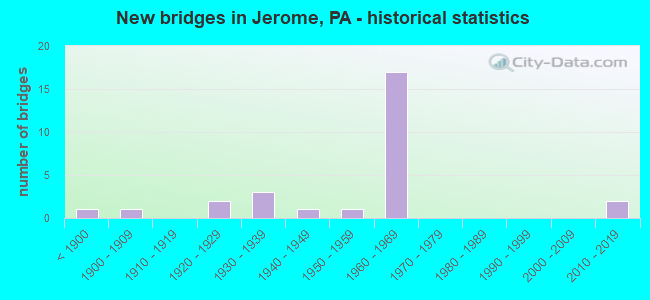
- New bridges - historical statistics
- 1Before 1900
- 11900-1909
- 21920-1929
- 31930-1939
- 11940-1949
- 11950-1959
- 171960-1969
- 22010-2019

- Reconstructed bridges - Historical Statistics
- 11970-1979
- 01980-1989
- 11990-1999
- 72000-2009
- 62010-2019


- Bridge Condition - Deck
- 5.3%Very good
- 36.8%Good
- 26.3%Satisfactory
- 26.3%Fair
- 5.3%Poor

- Bridge Condition - Superstructure
- 10.5%Very good
- 31.6%Good
- 21.1%Satisfactory
- 31.6%Fair
- 5.3%Poor

- Bridge Condition - Substructure
- 5.3%Very good
- 63.2%Satisfactory
- 15.8%Fair
- 10.5%Poor
- 5.3%Imminent failure

- Bridge Condition - Channel
- 16.7%Very good
- 33.3%Satisfactory
- 33.3%Fair
- 16.7%Poor
Find on map >> Show street view
Structure Number: 31413, Location: 2.57 MILE NORTH OF US 30 (Lat: 40.168283, Lng: -78.992756), Route carried "on" structure: US 219, Year Built: 1969, Year Reconstructed: 2010, Status: Open, Structure Length: 3.17m (10.40ft), Average Daily Traffic: 5,036 (year 2020), Truck Traffic: 7%, Average Future Daily Traffic: 5,283 (year 2032), Design Load: HS 20, Features Intersected: T741 PILLTOWN ROAD
Minimum Vertical Clearance: 30+ m (98+ ft), Kilometerpoint: 56.216, Lanes on structure: 2, Lanes under structure: 2, Base Highway Network: Yes, Owner: State Highway Agency, Approaching Roadway Width: 12.8m (42.0ft), Skew: 11 degrees, Material/Design: Prestressed concrete, Design/Construction: Box Beam or Girders - Single/Spread, Number Of Spans In Main Unit: 3, Length of Maximum Span: 11.0m (36.1ft), Curb or Sidewalk Widths: Left: 0.2m (0.7ft), Right: 0.2m (0.7ft), Curb-To-Curb Width: 12.2m (40.0ft), Out-to-Out Width: 13.4m (44.0ft)
Condition: Deck: Good, Superstructure: Good, Substructure: Satisfactory, Operating Rating: 50.8 metric tons, Method Used To Determine Operating Rating: Load Factor (LF), Inventory Rating: 29.9 metric tons, Method Used To Determine Inventory Rating: Load Factor (LF), Structural Evaluation: Equal to present minimum criteria, Deck Geometry: Better than present minimum criteria, Underclear: Meets minimum limits, Approach Roadway Alignment: Equal to present desirable criteria, Length Of Structure Improvement: 3.90m (12.80ft), Designated Inspection Frequency: Every 24 months, Inspection Date: July 2021, Deck Structure Type: Concrete Cast-file-Place, Wearing Surface/Protective System: Wearing Surface: Latex Concrete
Find on map >> Show street view
Structure Number: 31414, Location: 2.57 MILE NORTH OF US 30 (Lat: 40.168242, Lng: -78.993156), Route carried "on" structure: US 219, Year Built: 1969, Year Reconstructed: 2010, Status: Open, Structure Length: 3.17m (10.40ft), Average Daily Traffic: 5,034 (year 2020), Truck Traffic: 8%, Average Future Daily Traffic: 5,729 (year 2032), Design Load: HS 20, Features Intersected: T741 PILLTOWN ROAD
Minimum Vertical Clearance: 30+ m (98+ ft), Kilometerpoint: 56.259, Lanes on structure: 2, Lanes under structure: 2, Base Highway Network: Yes, Owner: State Highway Agency, Approaching Roadway Width: 12.8m (42.0ft), Skew: 11 degrees, Material/Design: Prestressed concrete, Design/Construction: Box Beam or Girders - Single/Spread, Number Of Spans In Main Unit: 3, Length of Maximum Span: 11.0m (36.1ft), Curb or Sidewalk Widths: Left: 0.2m (0.7ft), Right: 0.2m (0.7ft), Curb-To-Curb Width: 12.2m (40.0ft), Out-to-Out Width: 13.4m (44.0ft)
Condition: Deck: Fair, Superstructure: Fair, Substructure: Satisfactory, Operating Rating: 50.8 metric tons, Method Used To Determine Operating Rating: Load Factor (LF), Inventory Rating: 29.9 metric tons, Method Used To Determine Inventory Rating: Load Factor (LF), Structural Evaluation: Somewhat better than minimum adequacy, Deck Geometry: Better than present minimum criteria, Underclear: Meets minimum limits, Approach Roadway Alignment: Equal to present desirable criteria, Length Of Structure Improvement: 3.90m (12.80ft), Designated Inspection Frequency: Every 24 months, Inspection Date: July 2021, Deck Structure Type: Concrete Cast-file-Place, Wearing Surface/Protective System: Wearing Surface: Latex Concrete
Find on map >> Show street view
Structure Number: 31416, Location: OVER SR 4035 (Lat: 40.189881, Lng: -78.975333), Route carried "on" structure: US 219, Year Built: 1969, Year Reconstructed: 2010, Status: Open, Structure Length: 3.75m (12.30ft), Average Daily Traffic: 5,036 (year 2020), Truck Traffic: 7%, Average Future Daily Traffic: 5,283 (year 2032), Design Load: HS 20, Features Intersected: SR 4035
Minimum Vertical Clearance: 30+ m (98+ ft), Kilometerpoint: 58.797, Lanes on structure: 2, Lanes under structure: 2, Base Highway Network: Yes, Owner: State Highway Agency, Approaching Roadway Width: 12.2m (40.0ft), Skew: 13 degrees, Material/Design: Prestressed concrete, Design/Construction: Box Beam or Girders - Single/Spread, Number Of Spans In Main Unit: 3, Length of Maximum Span: 13.4m (44.0ft), Curb or Sidewalk Widths: Left: 0.2m (0.7ft), Right: 0.2m (0.7ft), Curb-To-Curb Width: 12.2m (40.0ft), Out-to-Out Width: 13.4m (44.0ft)
Condition: Deck: Satisfactory, Superstructure: Good, Substructure: Satisfactory, Operating Rating: 62.6 metric tons, Method Used To Determine Operating Rating: Load Factor (LF), Inventory Rating: 32.7 metric tons, Method Used To Determine Inventory Rating: Load Factor (LF), Structural Evaluation: Equal to present minimum criteria, Deck Geometry: Better than present minimum criteria, Underclear: Meets minimum limits, Approach Roadway Alignment: Equal to present desirable criteria, Length Of Structure Improvement: 4.60m (15.09ft), Designated Inspection Frequency: Every 24 months, Inspection Date: May 2021, Deck Structure Type: Concrete Cast-file-Place, Wearing Surface/Protective System: Wearing Surface: Latex Concrete
Find on map >> Show street view
Structure Number: 31417, Location: OVER SR 4035 (Lat: 40.189747, Lng: -78.975883), Route carried "on" structure: US 219, Year Built: 1969, Year Reconstructed: 2010, Status: Open, Structure Length: 3.75m (12.30ft), Average Daily Traffic: 5,034 (year 2020), Truck Traffic: 8%, Average Future Daily Traffic: 5,729 (year 2032), Design Load: HS 20, Features Intersected: SR 4035
Minimum Vertical Clearance: 30+ m (98+ ft), Kilometerpoint: 58.916, Lanes on structure: 2, Lanes under structure: 2, Base Highway Network: Yes, Owner: State Highway Agency, Approaching Roadway Width: 12.2m (40.0ft), Skew: 14 degrees, Material/Design: Prestressed concrete, Design/Construction: Box Beam or Girders - Single/Spread, Number Of Spans In Main Unit: 3, Length of Maximum Span: 13.7m (44.9ft), Curb or Sidewalk Widths: Left: 0.2m (0.7ft), Right: 0.2m (0.7ft), Curb-To-Curb Width: 12.2m (40.0ft), Out-to-Out Width: 13.4m (44.0ft)
Condition: Deck: Satisfactory, Superstructure: Good, Substructure: Satisfactory, Operating Rating: 59.9 metric tons, Method Used To Determine Operating Rating: Load Factor (LF), Inventory Rating: 35.4 metric tons, Method Used To Determine Inventory Rating: Load Factor (LF), Structural Evaluation: Equal to present minimum criteria, Deck Geometry: Better than present minimum criteria, Underclear: Meets minimum limits, Approach Roadway Alignment: Equal to present desirable criteria, Length Of Structure Improvement: 4.70m (15.42ft), Designated Inspection Frequency: Every 24 months, Inspection Date: May 2021, Deck Structure Type: Concrete Cast-file-Place, Wearing Surface/Protective System: Wearing Surface: Latex Concrete
Find on map >> Show street view
Structure Number: 31419, Location: OVER PA 601 (Lat: 40.204425, Lng: -78.974200), Route carried "on" structure: US 219, Year Built: 1969, Year Reconstructed: 2010, Status: Open, Structure Length: 3.41m (11.19ft), Average Daily Traffic: 4,695 (year 2020), Truck Traffic: 7%, Average Future Daily Traffic: 5,283 (year 2032), Design Load: HS 20, Features Intersected: PA 601
Minimum Vertical Clearance: 30+ m (98+ ft), Kilometerpoint: 60.869, Lanes on structure: 2, Lanes under structure: 2, Base Highway Network: Yes, Owner: State Highway Agency, Approaching Roadway Width: 12.8m (42.0ft), Skew: 11 degrees, Material/Design: Prestressed concrete, Design/Construction: Box Beam or Girders - Single/Spread, Number Of Spans In Main Unit: 3, Length of Maximum Span: 15.2m (49.9ft), Curb or Sidewalk Widths: Left: 0.2m (0.7ft), Right: 0.2m (0.7ft), Curb-To-Curb Width: 12.2m (40.0ft), Out-to-Out Width: 13.4m (44.0ft)
Condition: Deck: Good, Superstructure: Satisfactory, Substructure: Satisfactory, Operating Rating: 49.9 metric tons, Method Used To Determine Operating Rating: Load Factor (LF), Inventory Rating: 27.2 metric tons, Method Used To Determine Inventory Rating: Load Factor (LF), Structural Evaluation: Equal to present minimum criteria, Deck Geometry: Better than present minimum criteria, Underclear: Somewhat better than minimum adequacy, Approach Roadway Alignment: Equal to present desirable criteria, Length Of Structure Improvement: 4.20m (13.78ft), Designated Inspection Frequency: Every 24 months, Inspection Date: July 2021, Bridge Improvement Cost: $105,000, Roadway Improvement Cost: $308,000, Total Project Cost: $1,335,000, Deck Structure Type: Concrete Cast-file-Place, Wearing Surface/Protective System: Wearing Surface: Latex Concrete
Find on map >> Show street view
Structure Number: 3142, Location: OVER PA 601 (Lat: 40.204606, Lng: -78.974531), Route carried "on" structure: US 219, Year Built: 1969, Year Reconstructed: 2010, Status: Open, Structure Length: 3.47m (11.38ft), Average Daily Traffic: 4,636 (year 2020), Truck Traffic: 8%, Average Future Daily Traffic: 5,729 (year 2032), Design Load: HS 20, Features Intersected: PA 601
Minimum Vertical Clearance: 30+ m (98+ ft), Kilometerpoint: 60.935, Lanes on structure: 2, Lanes under structure: 2, Base Highway Network: Yes, Owner: State Highway Agency, Approaching Roadway Width: 12.8m (42.0ft), Skew: 11 degrees, Material/Design: Prestressed concrete, Design/Construction: Box Beam or Girders - Single/Spread, Number Of Spans In Main Unit: 3, Length of Maximum Span: 15.2m (49.9ft), Curb or Sidewalk Widths: Left: 0.2m (0.7ft), Right: 0.2m (0.7ft), Curb-To-Curb Width: 12.2m (40.0ft), Out-to-Out Width: 13.4m (44.0ft)
Condition: Deck: Good, Superstructure: Satisfactory, Substructure: Satisfactory, Operating Rating: 49.9 metric tons, Method Used To Determine Operating Rating: Load Factor (LF), Inventory Rating: 27.2 metric tons, Method Used To Determine Inventory Rating: Load Factor (LF), Structural Evaluation: Equal to present minimum criteria, Deck Geometry: Better than present minimum criteria, Underclear: Equal to present minimum criteria, Approach Roadway Alignment: Equal to present desirable criteria, Length Of Structure Improvement: 4.30m (14.11ft), Designated Inspection Frequency: Every 24 months, Inspection Date: July 2021, Bridge Improvement Cost: $173,000, Roadway Improvement Cost: $510,000, Total Project Cost: $2,157,000, Deck Structure Type: Concrete Cast-file-Place, Wearing Surface/Protective System: Wearing Surface: Latex Concrete
Find on map >> Show street view
Structure Number: 31421, Location: OVER SR 4016 (Lat: 40.213692, Lng: -78.955619), Route carried "on" structure: US 219, Year Built: 1969, Year Reconstructed: 2011, Status: Open, Structure Length: 5.70m (18.70ft), Average Daily Traffic: 4,695 (year 2020), Truck Traffic: 7%, Average Future Daily Traffic: 5,283 (year 2032), Design Load: HS 20, Features Intersected: SR 4016
Minimum Vertical Clearance: 30+ m (98+ ft), Kilometerpoint: 62.814, Lanes on structure: 2, Lanes under structure: 2, Base Highway Network: Yes, Owner: State Highway Agency, Approaching Roadway Width: 12.2m (40.0ft), Skew: 11 degrees, Material/Design: Prestressed concrete, Design/Construction: Box Beam or Girders - Single/Spread, Number Of Spans In Main Unit: 3, Length of Maximum Span: 21.3m (69.9ft), Curb or Sidewalk Widths: Left: 0.2m (0.7ft), Right: 0.2m (0.7ft), Curb-To-Curb Width: 12.2m (40.0ft), Out-to-Out Width: 13.4m (44.0ft)
Condition: Deck: Good, Superstructure: Good, Substructure: Satisfactory, Operating Rating: 54.4 metric tons, Method Used To Determine Operating Rating: Load Factor (LF), Inventory Rating: 28.1 metric tons, Method Used To Determine Inventory Rating: Load Factor (LF), Structural Evaluation: Equal to present minimum criteria, Deck Geometry: Better than present minimum criteria, Underclear: Meets minimum limits, Approach Roadway Alignment: Equal to present desirable criteria, Length Of Structure Improvement: 7.10m (23.29ft), Designated Inspection Frequency: Every 24 months, Inspection Date: August 2021, Bridge Improvement Cost: $276,000, Roadway Improvement Cost: $813,000, Total Project Cost: $3,435,000, Deck Structure Type: Concrete Cast-file-Place, Wearing Surface/Protective System: Wearing Surface: Latex Concrete
Find on map >> Show street view
Structure Number: 31422, Location: OVER SR 4016 (Lat: 40.213964, Lng: -78.955917), Route carried "on" structure: US 219, Year Built: 1969, Year Reconstructed: 2011, Status: Open, Structure Length: 5.70m (18.70ft), Average Daily Traffic: 4,636 (year 2020), Truck Traffic: 8%, Average Future Daily Traffic: 5,729 (year 2032), Design Load: HS 20, Features Intersected: SR 4016
Minimum Vertical Clearance: 30+ m (98+ ft), Kilometerpoint: 62.888, Lanes on structure: 2, Lanes under structure: 2, Base Highway Network: Yes, Owner: State Highway Agency, Approaching Roadway Width: 12.2m (40.0ft), Skew: 11 degrees, Material/Design: Prestressed concrete, Design/Construction: Box Beam or Girders - Single/Spread, Number Of Spans In Main Unit: 3, Length of Maximum Span: 21.3m (69.9ft), Curb or Sidewalk Widths: Left: 0.2m (0.7ft), Right: 0.2m (0.7ft), Curb-To-Curb Width: 12.2m (40.0ft), Out-to-Out Width: 13.4m (44.0ft)
Condition: Deck: Good, Superstructure: Good, Substructure: Satisfactory, Operating Rating: 54.4 metric tons, Method Used To Determine Operating Rating: Load Factor (LF), Inventory Rating: 28.1 metric tons, Method Used To Determine Inventory Rating: Load Factor (LF), Structural Evaluation: Equal to present minimum criteria, Deck Geometry: Better than present minimum criteria, Underclear: Meets minimum limits, Approach Roadway Alignment: Equal to present desirable criteria, Length Of Structure Improvement: 7.10m (23.29ft), Designated Inspection Frequency: Every 24 months, Inspection Date: August 2021, Bridge Improvement Cost: $78,000, Roadway Improvement Cost: $293,000, Total Project Cost: $1,053,000, Deck Structure Type: Concrete Cast-file-Place, Wearing Surface/Protective System: Wearing Surface: Latex Concrete
Find on map >> Show street view
Structure Number: 31479, Location: 0.5 MILE NORTH OF US 219 (Lat: 40.201578, Lng: -78.966036), Route carried "on" structure: State highway 601, Year Built: 1969, Status: Open, Structure Length: 0.70m (2.30ft), Average Daily Traffic: 749 (year 2022), Truck Traffic: 20%, Average Future Daily Traffic: 957 (year 2032), Design Load: HS 20, Features Intersected: TR.QUEMAHONING CREEK
Minimum Vertical Clearance: 30+ m (98+ ft), Kilometerpoint: 28.405, Lanes on structure: 2, Owner: State Highway Agency, Approaching Roadway Width: 11.0m (36.1ft), Skew: 1 degrees, Material/Design: Concrete, Design/Construction: Slab, Number Of Spans In Main Unit: 1, Length of Maximum Span: 6.4m (21.0ft), Curb or Sidewalk Widths: Left: 0.2m (0.7ft), Right: 0.2m (0.7ft), Curb-To-Curb Width: 12.2m (40.0ft), Out-to-Out Width: 13.4m (44.0ft)
Condition: Deck: Satisfactory, Superstructure: Satisfactory, Substructure: Satisfactory, Channel: Fair, Operating Rating: 57.2 metric tons, Method Used To Determine Operating Rating: Load Factor (LF), Inventory Rating: 33.6 metric tons, Method Used To Determine Inventory Rating: Load Factor (LF), Structural Evaluation: Equal to present minimum criteria, Deck Geometry: Equal to present desirable criteria, Waterway Adequacy: Equal to present minimum criteria, Approach Roadway Alignment: Equal to present desirable criteria, Length Of Structure Improvement: 1.30m (4.27ft), Designated Inspection Frequency: Every 24 months, Inspection Date: September 2021, Wearing Surface/Protective System: Wearing Surface: Bituminous, Membrane: Preformed Fabric
Find on map >> Show street view
Structure Number: 31502, Location: FORWARDSTOWN (Lat: 40.219164, Lng: -79.029864), Route carried "on" structure: State highway 985, Year Built: 1931, Year Reconstructed: 2006, Status: Open, Structure Length: 1.10m (3.61ft), Average Daily Traffic: 1,011 (year 2022), Truck Traffic: 4%, Average Future Daily Traffic: 1,328 (year 2032), Design Load: HS 20, Features Intersected: S FORK BRANCH BENS CREEK
Minimum Vertical Clearance: 30+ m (98+ ft), Kilometerpoint: 19.323, Lanes on structure: 2, Base Highway Network: Yes, Owner: State Highway Agency, Approaching Roadway Width: 9.4m (30.8ft), Skew: 1 degrees, Material/Design: Concrete, Design/Construction: Tee Beam, Number Of Spans In Main Unit: 1, Length of Maximum Span: 10.4m (34.1ft), Curb-To-Curb Width: 9.6m (31.5ft), Out-to-Out Width: 10.7m (35.1ft)
Condition: Deck: Fair, Superstructure: Fair, Substructure: Fair, Channel: Fair, Operating Rating: 56.2 metric tons, Method Used To Determine Operating Rating: Load Factor (LF), Inventory Rating: 31.8 metric tons, Method Used To Determine Inventory Rating: Load Factor (LF), Structural Evaluation: Somewhat better than minimum adequacy, Deck Geometry: Somewhat better than minimum adequacy, Waterway Adequacy: Equal to present minimum criteria, Approach Roadway Alignment: Better than present minimum criteria, Length Of Structure Improvement: 1.40m (4.59ft), Designated Inspection Frequency: Every 24 months, Inspection Date: August 2021, Bridge Improvement Cost: $50,000, Roadway Improvement Cost: $264,000, Total Project Cost: $674,000, Deck Structure Type: Concrete Cast-file-Place, Wearing Surface/Protective System: Wearing Surface: Bituminous, Membrane: Preformed Fabric
Find on map >> Show street view
Structure Number: 31504, Location: THOMAS MILLS (Lat: 40.225681, Lng: -78.987294), Route carried "on" structure: State highway 985, Year Built: 1921, Year Reconstructed: 2014, Status: Open, Structure Length: 0.67m (2.20ft), Average Daily Traffic: 1,011 (year 2022), Truck Traffic: 4%, Average Future Daily Traffic: 1,328 (year 2032), Features Intersected: TRIB.TO BENS CREEK
Minimum Vertical Clearance: 30+ m (98+ ft), Kilometerpoint: 23.162, Lanes on structure: 2, Base Highway Network: Yes, Owner: State Highway Agency, Approaching Roadway Width: 9.1m (29.9ft), Material/Design: Concrete, Design/Construction: Slab, Number Of Spans In Main Unit: 1, Length of Maximum Span: 6.4m (21.0ft), Curb-To-Curb Width: 9.2m (30.2ft), Out-to-Out Width: 10.0m (32.8ft)
Condition: Deck: Satisfactory, Superstructure: Satisfactory, Substructure: Satisfactory, Channel: Satisfactory, Operating Rating: 76.2 metric tons, Method Used To Determine Operating Rating: Field evaluation and documented engineering judgment, Inventory Rating: 45.4 metric tons, Method Used To Determine Inventory Rating: Field evaluation and documented engineering judgment, Structural Evaluation: Equal to present minimum criteria, Deck Geometry: Somewhat better than minimum adequacy, Waterway Adequacy: Equal to present minimum criteria, Approach Roadway Alignment: Equal to present desirable criteria, Length Of Structure Improvement: 1.30m (4.27ft), Designated Inspection Frequency: Every 24 months, Inspection Date: August 2021, Deck Structure Type: Concrete Cast-file-Place, Wearing Surface/Protective System: Wearing Surface: Monolithic Concrete, Deck Protection: Epoxy Coated Reinforcing
Find on map >> Show street view
Structure Number: 31776, Location: FORWARDSTOWN (Lat: 40.221564, Lng: -79.034544), Route carried "on" structure: State highway , Year Built: 1938, Year Reconstructed: 1997, Status: Open, Structure Length: 1.19m (3.90ft), Average Daily Traffic: 248 (year 2022), Truck Traffic: 1%, Average Future Daily Traffic: 380 (year 2032), Design Load: HS 25 or greater, Features Intersected: SOUTH FORK BENS CREEK, Facility Carried by Structure: SR 4027
Minimum Vertical Clearance: 30+ m (98+ ft), Kilometerpoint: 9.688, Lanes on structure: 2, Owner: State Highway Agency, Approaching Roadway Width: 5.8m (19.0ft), Skew: 3 degrees, Material/Design: Steel, Design/Construction: Stringer/Multi-beam, Number Of Spans In Main Unit: 1, Length of Maximum Span: 11.6m (38.1ft), Curb-To-Curb Width: 7.1m (23.3ft), Out-to-Out Width: 7.6m (24.9ft)
Condition: Deck: Fair, Superstructure: Fair, Substructure: Satisfactory, Channel: Fair, Inventory Rating: 60.8 metric tons, Method Used To Determine Inventory Rating: Load Factor (LF), Structural Evaluation: Somewhat better than minimum adequacy, Deck Geometry: Meets minimum limits, Waterway Adequacy: Better than present minimum criteria, Approach Roadway Alignment: Equal to present desirable criteria, Length Of Structure Improvement: 1.50m (4.92ft), Designated Inspection Frequency: Every 24 months, Inspection Date: August 2021, Bridge Improvement Cost: $52,000, Roadway Improvement Cost: $264,000, Total Project Cost: $700,000, Deck Structure Type: Concrete Cast-file-Place, Wearing Surface/Protective System: Wearing Surface: Bituminous, Deck Protection: Epoxy Coated Reinforcing
Find on map >> Show street view
Structure Number: 31778, Location: 1 MILE W. SULPHUR SPRINGS (Lat: 40.268414, Lng: -78.999358), Route carried "on" structure: State highway , Year Built: 1927, Status: Open, Structure Length: 1.37m (4.49ft), Average Daily Traffic: 91 (year 2020), Truck Traffic: 9%, Average Future Daily Traffic: 135 (year 2032), Design Load: HS 20, Features Intersected: NORTH FORK BENS CREEK, Facility Carried by Structure: SR 4029
Minimum Vertical Clearance: 30+ m (98+ ft), Kilometerpoint: 7.390, Lanes on structure: 2, Owner: State Highway Agency, Approaching Roadway Width: 5.2m (17.1ft), Skew: 1 degrees, Material/Design: Concrete, Design/Construction: Tee Beam, Number Of Spans In Main Unit: 2, Length of Maximum Span: 6.7m (22.0ft), Curb or Sidewalk Widths: Left: 0.2m (0.7ft), Right: 0.2m (0.7ft), Curb-To-Curb Width: 6.0m (19.7ft), Out-to-Out Width: 6.7m (22.0ft)
Condition: Deck: Poor, Superstructure: Poor, Substructure: Fair, Channel: Poor, Operating Rating: 78.0 metric tons, Method Used To Determine Operating Rating: Field evaluation and documented engineering judgment, Inventory Rating: 46.3 metric tons, Method Used To Determine Inventory Rating: Field evaluation and documented engineering judgment, Structural Evaluation: Meets minimum limits, Deck Geometry: Meets minimum limits, Waterway Adequacy: Better than present minimum criteria, Approach Roadway Alignment: Better than present minimum criteria, Length Of Structure Improvement: 1.70m (5.58ft), Designated Inspection Frequency: Every 24 months, Inspection Date: September 2021, Bridge Improvement Cost: $56,000, Roadway Improvement Cost: $264,000, Total Project Cost: $750,000, Deck Structure Type: Concrete Cast-file-Place, Wearing Surface/Protective System: Wearing Surface: Bituminous
Find on map >> Show street view
Structure Number: 31844, Location: 2.1 MI.N.OF THOMAS MILLS (Lat: 40.250550, Lng: -78.972089), Route carried "on" structure: City street , Year Built: 1900, Year Reconstructed: 2014, Status: Open, Structure Length: 1.28m (4.20ft), Average Daily Traffic: 150 (year 2020), Average Future Daily Traffic: 210 (year 2040), Design Load: HS 25 or greater, Features Intersected: BENS CREEK, Facility Carried by Structure: T733,KEAFER HILL R
Minimum Vertical Clearance: 30+ m (98+ ft), Kilometerpoint: 0.000, Lanes on structure: 2, Owner: County Highway Agency, Approaching Roadway Width: 4.9m (16.1ft), Material/Design: Prestressed concrete, Design/Construction: Box Beam or Girders - Multiple, Number Of Spans In Main Unit: 1, Length of Maximum Span: 12.5m (41.0ft), Curb-To-Curb Width: 5.5m (18.0ft), Out-to-Out Width: 6.2m (20.3ft)
Condition: Deck: Very good, Superstructure: Good, Substructure: Satisfactory, Channel: Poor, Operating Rating: 88.0 metric tons, Method Used To Determine Operating Rating: Load Factor (LF), Inventory Rating: 52.6 metric tons, Method Used To Determine Inventory Rating: Load Factor (LF), Structural Evaluation: Equal to present minimum criteria, Deck Geometry: High priority of corrective action, Waterway Adequacy: Meets minimum limits, Approach Roadway Alignment: Equal to present desirable criteria, Length Of Structure Improvement: 1.60m (5.25ft), Designated Inspection Frequency: Every 24 months, Inspection Date: August 2020, Bridge Improvement Cost: $4,000, Roadway Improvement Cost: $13,000, Total Project Cost: $59,000, Wearing Surface/Protective System: Wearing Surface: Monolithic Concrete, Deck Protection: Epoxy Coated Reinforcing
Find on map >> Show street view
Structure Number: 31858, Location: 1.5 MI.SW.OF THOMAS MILLS (Lat: 40.219986, Lng: -79.012300), Route carried "on" structure: City street , Year Built: 1895, Year Reconstructed: 1984, Status: Open, Structure Length: 1.43m (4.69ft), Average Daily Traffic: 50 (year 2021), Average Future Daily Traffic: 63 (year 2041), Design Load: HS 25 or greater, Features Intersected: BENS CREEK, Facility Carried by Structure: T-586 BREHM ROAD
Minimum Vertical Clearance: 30+ m (98+ ft), Kilometerpoint: 0.000, Lanes on structure: 2, Owner: County Highway Agency, Approaching Roadway Width: 3.7m (12.1ft), Material/Design: Prestressed concrete, Design/Construction: Box Beam or Girders - Multiple, Number Of Spans In Main Unit: 1, Length of Maximum Span: 14.0m (45.9ft), Curb-To-Curb Width: 4.9m (16.1ft), Out-to-Out Width: 4.9m (16.1ft)
Condition: Deck: Satisfactory, Superstructure: Fair, Substructure: Poor, Channel: Satisfactory, Operating Rating: 61.7 metric tons, Method Used To Determine Operating Rating: Load Factor (LF), Inventory Rating: 37.2 metric tons, Method Used To Determine Inventory Rating: Load Factor (LF), Structural Evaluation: Meets minimum limits, Deck Geometry: High priority of corrective action, Waterway Adequacy: Equal to present desirable criteria, Approach Roadway Alignment: Equal to present desirable criteria, Length Of Structure Improvement: 1.80m (5.91ft), Designated Inspection Frequency: Every 24 months, Other Special Inspection Frequency: Every 12 months, Inspection Date: October 2020, Other Special Inspection Date: October 2021, Bridge Improvement Cost: $57,000, Roadway Improvement Cost: $264,000, Total Project Cost: $771,000, Deck Structure Type: Other, Wearing Surface/Protective System: Wearing Surface: Bituminous
Find on map >> Show street view
Structure Number: 31859, Location: 2.5 MI.E.OF BOSWELL (Lat: 40.157194, Lng: -78.982789), Route carried "on" structure: City street , Year Built: 1939, Year Reconstructed: 2014, Status: Open, Structure Length: 5.24m (17.19ft), Average Daily Traffic: 350 (year 2020), Truck Traffic: 1%, Average Future Daily Traffic: 438 (year 2040), Design Load: HL 93, Features Intersected: QUEMAHONING RESERVOIR, Facility Carried by Structure: T-628, Q.DAM ROAD
Minimum Vertical Clearance: 30+ m (98+ ft), Kilometerpoint: 0.000, Lanes on structure: 2, Owner: County Highway Agency, Approaching Roadway Width: 6.7m (22.0ft), Material/Design: Steel continuous, Design/Construction: Stringer/Multi-beam, Number Of Spans In Main Unit: 2, Length of Maximum Span: 25.9m (85.0ft), Curb-To-Curb Width: 6.7m (22.0ft), Out-to-Out Width: 7.6m (24.9ft)
Condition: Deck: Good, Superstructure: Very good, Substructure: Fair, Channel: Satisfactory, Operating Rating: 51.5 metric tons, Method Used To Determine Operating Rating: Assigned ratings based on Load and Resistance Factor Design (LRFD) reported by rating factor (RF) using HL93 loadings, Inventory Rating: 35.6 metric tons, Method Used To Determine Inventory Rating: Assigned ratings based on Load and Resistance Factor Design (LRFD) reported by rating factor (RF) using HL93 loadings, Structural Evaluation: Somewhat better than minimum adequacy, Deck Geometry: Meets minimum limits, Waterway Adequacy: Better than present minimum criteria, Approach Roadway Alignment: Equal to present minimum criteria, Length Of Structure Improvement: 6.50m (21.33ft), Designated Inspection Frequency: Every 24 months, Underwater Inspection Frequency: Every 60 months, Inspection Date: May 2020, Underwater Inspection Date: September 2019, Bridge Improvement Cost: $158,000, Roadway Improvement Cost: $466,000, Total Project Cost: $2,134,000, Deck Structure Type: Concrete Cast-file-Place, Wearing Surface/Protective System: Wearing Surface: Monolithic Concrete, Deck Protection: Epoxy Coated Reinforcing
Find on map >> Show street view
Structure Number: 3186, Location: 1.5 MI.NW.OF JEROME (Lat: 40.220106, Lng: -79.020267), Route carried "on" structure: City street , Year Built: 1940, Status: Closed, Structure Length: 0.88m (2.89ft), Average Daily Traffic: 103 (year 2020), Truck Traffic: 1%, Average Future Daily Traffic: 128 (year 2040), Design Load: H 10, Features Intersected: BENS CREEK, Facility Carried by Structure: T-771,CIRCLE ROAD
Minimum Vertical Clearance: 30+ m (98+ ft), Kilometerpoint: 0.000, Lanes on structure: 2, Owner: Town or Township Highway Agency, Approaching Roadway Width: 4.0m (13.1ft), Material/Design: Steel, Design/Construction: Stringer/Multi-beam, Number Of Spans In Main Unit: 1, Length of Maximum Span: 7.9m (25.9ft), Curb-To-Curb Width: 5.0m (16.4ft), Out-to-Out Width: 5.2m (17.1ft)
Condition: Deck: Fair, Superstructure: Fair, Substructure: Imminent failure, Channel: Fair, Operating Rating: 28.1 metric tons, Method Used To Determine Operating Rating: Load Factor (LF), Inventory Rating: 16.3 metric tons, Method Used To Determine Inventory Rating: Load Factor (LF), Waterway Adequacy: Better than present minimum criteria, Approach Roadway Alignment: High priority of corrective action, Bridge Posting: Required (Relationship of Operating Rating to Maximum Legal Load: > 39.9% below), Length Of Structure Improvement: 1.10m (3.61ft), Designated Inspection Frequency: Every 24 months, Inspection Date: May 2020, Bridge Improvement Cost: $43,000, Roadway Improvement Cost: $242,000, Total Project Cost: $579,000, Deck Structure Type: Open Grating
Find on map >> Show street view
Structure Number: 48205, Location: 1.5mi North of Thomas Mil (Lat: 40.245275, Lng: -78.973592), Route carried "on" structure: City street , Year Built: 1950, Year Reconstructed: 2006, Status: Open, Structure Length: 1.01m (3.31ft), Average Daily Traffic: 50 (year 2021), Truck Traffic: 2%, Average Future Daily Traffic: 60 (year 2041), Design Load: HL 93, Features Intersected: Bens Creek, Facility Carried by Structure: T-433, Hillside Dr
Minimum Vertical Clearance: 30+ m (98+ ft), Kilometerpoint: 0.000, Lanes on structure: 1, Owner: Town or Township Highway Agency, Approaching Roadway Width: 3.4m (11.2ft), Material/Design: Steel, Design/Construction: Stringer/Multi-beam, Number Of Spans In Main Unit: 1, Length of Maximum Span: 9.4m (30.8ft), Curb-To-Curb Width: 3.4m (11.2ft), Out-to-Out Width: 3.6m (11.8ft)
Condition: Deck: Fair, Superstructure: Fair, Substructure: Poor, Channel: Satisfactory, Inventory Rating: 67.1 metric tons, Method Used To Determine Inventory Rating: Load Factor (LF), Structural Evaluation: Meets minimum limits, Deck Geometry: High priority of corrective action, Waterway Adequacy: Meets minimum limits, Approach Roadway Alignment: Better than present minimum criteria, Designated Inspection Frequency: Every 24 months, Inspection Date: July 2021, Deck Structure Type: Open Grating
Find on map >> Show street view
Structure Number: 48923, Location: .25 MI W OF FORWARDSTOWN (Lat: 40.223875, Lng: -79.038544), Route carried "on" structure: State highway , Year Built: 2014, Status: Open, Structure Length: 0.91m (2.99ft), Average Daily Traffic: 74 (year 2020), Truck Traffic: 9%, Average Future Daily Traffic: 90 (year 2034), Design Load: HL 93, Features Intersected: SOUTH FORK OF BENS CREEK, Facility Carried by Structure: SR 4027
Minimum Vertical Clearance: 30+ m (98+ ft), Kilometerpoint: 8.705, Lanes on structure: 2, Owner: State Highway Agency, Approaching Roadway Width: 7.3m (24.0ft), Skew: 3 degrees, Material/Design: Concrete, Design/Construction: Culvert, Number Of Spans In Main Unit: 1, Length of Maximum Span: 7.3m (24.0ft), Curb-To-Curb Width: 7.3m (24.0ft), Out-to-Out Width: 12.8m (42.0ft)
Condition: Channel: Very good, Culverts: Very good, Operating Rating: 53.8 metric tons, Method Used To Determine Operating Rating: Assigned ratings based on Load and Resistance Factor Design (LRFD) reported by rating factor (RF) using HL93 loadings, Inventory Rating: 34.0 metric tons, Method Used To Determine Inventory Rating: Assigned ratings based on Load and Resistance Factor Design (LRFD) reported by rating factor (RF) using HL93 loadings, Structural Evaluation: Equal to present desirable criteria, Deck Geometry: Equal to present minimum criteria, Waterway Adequacy: Better than present minimum criteria, Approach Roadway Alignment: Equal to present desirable criteria, Length Of Structure Improvement: 0.91m (2.99ft), Designated Inspection Frequency: Every 24 months, Inspection Date: August 2021, Wearing Surface/Protective System: Wearing Surface: Bituminous, Membrane: Preformed Fabric, Deck Protection: Epoxy Coated Reinforcing
Find on map >> Show street view
Structure Number: 52614, Location: 1 MI N OF THOMAS MILLS (Lat: 40.231067, Lng: -78.981506), Route carried "on" structure: State highway , Year Built: 2015, Status: Open, Structure Length: 1.62m (5.31ft), Average Daily Traffic: 875 (year 2020), Truck Traffic: 1%, Average Future Daily Traffic: 907 (year 2035), Design Load: HL 93, Features Intersected: SOUTH FORK BENS CREEK, Facility Carried by Structure: SR 4016
Minimum Vertical Clearance: 30+ m (98+ ft), Kilometerpoint: 0.000, Lanes on structure: 2, Owner: State Highway Agency, Approaching Roadway Width: 9.8m (32.2ft), Skew: 1 degrees, Material/Design: Prestressed concrete, Design/Construction: Box Beam or Girders - Single/Spread, Number Of Spans In Main Unit: 1, Length of Maximum Span: 15.8m (51.8ft), Curb or Sidewalk Widths: Left: 0.2m (0.7ft), Right: 0.2m (0.7ft), Curb-To-Curb Width: 9.8m (32.2ft), Out-to-Out Width: 10.8m (35.4ft)
Condition: Deck: Good, Superstructure: Very good, Substructure: Very good, Channel: Very good, Operating Rating: 50.9 metric tons, Method Used To Determine Operating Rating: Assigned ratings based on Load and Resistance Factor Design (LRFD) reported by rating factor (RF) using HL93 loadings, Inventory Rating: 39.2 metric tons, Method Used To Determine Inventory Rating: Assigned ratings based on Load and Resistance Factor Design (LRFD) reported by rating factor (RF) using HL93 loadings, Structural Evaluation: Equal to present desirable criteria, Deck Geometry: Equal to present minimum criteria, Waterway Adequacy: Equal to present desirable criteria, Approach Roadway Alignment: Equal to present desirable criteria, Designated Inspection Frequency: Every 48 months, Inspection Date: September 2019, Deck Structure Type: Concrete Cast-file-Place, Wearing Surface/Protective System: Wearing Surface: Monolithic Concrete, Deck Protection: Epoxy Coated Reinforcing
Find on map >> Show street view
Structure Number: 31413, Location: 2.57 MILE NORTH OF US 30 (Lat: 40.168283, Lng: -78.992756), Route carried "under" structure: City street , Year Built: 1969, Structure Length: 0. m, Average Daily Traffic: 25 (year 1993), Features Intersected: T741 PILLTOWN ROAD, Facility Carried by Structure: US 219 NBL
Minimum Vertical Clearance: 4.62m (15.16ft), Kilometerpoint: 0.000, Lanes on structure: 2, Lanes under structure: 2, Material/Design: Prestressed concrete, Design/Construction: Box Beam or Girders - Single/Spread, Length of Maximum Span: 11.0m (36.1ft)
Find on map >> Show street view
Structure Number: 31414, Location: 2.57 MILE NORTH OF US 30 (Lat: 40.168242, Lng: -78.993156), Route carried "under" structure: City street , Year Built: 1969, Structure Length: 0. m, Average Daily Traffic: 25 (year 1993), Truck Traffic: 9%, Features Intersected: T741 PILLTOWN ROAD, Facility Carried by Structure: US 219 SBL
Minimum Vertical Clearance: 5.13m (16.83ft), Kilometerpoint: 0.000, Lanes on structure: 2, Lanes under structure: 2, Material/Design: Prestressed concrete, Design/Construction: Box Beam or Girders - Single/Spread, Length of Maximum Span: 11.0m (36.1ft)
Find on map >> Show street view
Structure Number: 31416, Location: OVER SR 4035 (Lat: 40.189881, Lng: -78.975333), Route carried "under" structure: State highway , Year Built: 1969, Structure Length: 0. m, Average Daily Traffic: 179 (year 2020), Truck Traffic: 2%, Features Intersected: SR 4035, Facility Carried by Structure: US 219 NBL
Minimum Vertical Clearance: 4.52m (14.83ft), Kilometerpoint: 3.833, Lanes on structure: 2, Lanes under structure: 2, Material/Design: Prestressed concrete, Design/Construction: Box Beam or Girders - Single/Spread, Length of Maximum Span: 13.4m (44.0ft)
Find on map >> Show street view
Structure Number: 31417, Location: OVER SR 4035 (Lat: 40.189747, Lng: -78.975883), Route carried "under" structure: State highway , Year Built: 1969, Structure Length: 0. m, Average Daily Traffic: 179 (year 2020), Truck Traffic: 2%, Features Intersected: SR 4035, Facility Carried by Structure: US 219 SBL
Minimum Vertical Clearance: 4.40m (14.44ft), Kilometerpoint: 3.833, Lanes on structure: 2, Lanes under structure: 2, Material/Design: Prestressed concrete, Design/Construction: Box Beam or Girders - Single/Spread, Length of Maximum Span: 13.7m (44.9ft)
Find on map >> Show street view
Structure Number: 31419, Location: OVER PA 601 (Lat: 40.204425, Lng: -78.974200), Route carried "under" structure: State highway 601, Year Built: 1969, Structure Length: 0. m, Average Daily Traffic: 749 (year 2022), Truck Traffic: 20%, Features Intersected: PA 601, Facility Carried by Structure: US 219 NBL
Minimum Vertical Clearance: 4.50m (14.76ft), Kilometerpoint: 27.608, Lanes on structure: 2, Lanes under structure: 2, Material/Design: Prestressed concrete, Design/Construction: Box Beam or Girders - Single/Spread, Length of Maximum Span: 15.2m (49.9ft)
Find on map >> Show street view
Structure Number: 3142, Location: OVER PA 601 (Lat: 40.204606, Lng: -78.974531), Route carried "under" structure: State highway 601, Year Built: 1969, Structure Length: 0. m, Average Daily Traffic: 749 (year 2022), Truck Traffic: 20%, Features Intersected: PA 601, Facility Carried by Structure: US 219 SBL
Minimum Vertical Clearance: 4.67m (15.32ft), Kilometerpoint: 26.987, Lanes on structure: 2, Lanes under structure: 2, Material/Design: Prestressed concrete, Design/Construction: Box Beam or Girders - Single/Spread, Length of Maximum Span: 15.2m (49.9ft)
Find on map >> Show street view
Structure Number: 31421, Location: OVER SR 4016 (Lat: 40.213692, Lng: -78.955619), Route carried "under" structure: State highway , Year Built: 1969, Structure Length: 0. m, Average Daily Traffic: 493 (year 2022), Truck Traffic: 9%, Features Intersected: SR 4016, Facility Carried by Structure: US 219 NBL
Minimum Vertical Clearance: 7.62m (25.00ft), Kilometerpoint: 3.043, Lanes on structure: 2, Lanes under structure: 2, Material/Design: Prestressed concrete, Design/Construction: Box Beam or Girders - Single/Spread, Length of Maximum Span: 21.3m (69.9ft)
Find on map >> Show street view
Structure Number: 31422, Location: OVER SR 4016 (Lat: 40.213964, Lng: -78.955917), Route carried "under" structure: State highway , Year Built: 1969, Structure Length: 0. m, Average Daily Traffic: 493 (year 2022), Truck Traffic: 9%, Features Intersected: SR 4016, Facility Carried by Structure: US 219 SBL
Minimum Vertical Clearance: 7.62m (25.00ft), Kilometerpoint: 3.043, Lanes on structure: 2, Lanes under structure: 2, Material/Design: Prestressed concrete, Design/Construction: Box Beam or Girders - Single/Spread, Length of Maximum Span: 21.3m (69.9ft)