Bridge Statistics for Jennings, Florida (FL)
Condition, Traffic, Stress, Structural Evaluation, Project Costs
- National Bridge Inventory (NBI) Statistics
- 14Number of bridges
- 157ft / 48.4mTotal length
- 170,249Total average daily traffic
- 53,291Total average daily truck traffic
- National Bridge Inventory (NBI) Registered Bridges for Jennings
- No street view available for this location
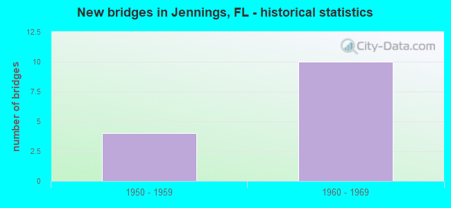
- New bridges - historical statistics
- 41950-1959
- 101960-1969

- Reconstructed bridges - Historical Statistics
- 11960-1969
- 01970-1979
- 11980-1989


- Bridge Condition - Deck
- 60.0%Good
- 40.0%Satisfactory

- Bridge Condition - Substructure
- 20.0%Very good
- 60.0%Good
- 20.0%Satisfactory

- Bridge Condition - Channel
- 60.0%Satisfactory
- 40.0%Fair

- Bridge Condition - Culverts
- 50.0%Satisfactory
- 50.0%Fair
Find on map >> Show street view
Structure Number: 320018, Location: SR-143 / I-75 (Lat: 30.594503, Lng: -83.119719), Route carried "on" structure: State highway 143, Year Built: 1961, Status: Open, Structure Length: 6.86m (22.51ft), Average Daily Traffic: 1,300 (year 2020), Truck Traffic: 7%, Average Future Daily Traffic: 2,256 (year 2042), Design Load: HS 20, Features Intersected: I-75 (SR-93)
Minimum Vertical Clearance: 30+ m (98+ ft), Kilometerpoint: 16.557, Lanes on structure: 2, Lanes under structure: 6, Base Highway Network: Yes, Owner: State Highway Agency, Approaching Roadway Width: 7.3m (24.0ft), Material/Design: Prestressed concrete, Design/Construction: Stringer/Multi-beam, Number Of Spans In Main Unit: 4, Length of Maximum Span: 23.5m (77.1ft), Curb-To-Curb Width: 8.5m (27.9ft), Out-to-Out Width: 10.1m (33.1ft)
Condition: Deck: Good, Superstructure: Good, Substructure: Good, Operating Rating: 66.6 metric tons, Method Used To Determine Operating Rating: Load and Resistance Factor (LRFR), Inventory Rating: 32.7 metric tons, Method Used To Determine Inventory Rating: Load and Resistance Factor (LRFR), Structural Evaluation: Better than present minimum criteria, Deck Geometry: Somewhat better than minimum adequacy, Underclear: Somewhat better than minimum adequacy, Approach Roadway Alignment: Equal to present desirable criteria, Designated Inspection Frequency: Every 24 months, Inspection Date: Febuary 2022, Deck Structure Type: Concrete Cast-file-Place
Find on map >> Show street view
Structure Number: 320022, Location: 0.1MI SOUTH OF CR 152 (Lat: 30.554611, Lng: -83.099486), Route carried "on" structure: County highway 141, Year Built: 1968, Status: Open, Structure Length: 0.95m (3.12ft), Average Daily Traffic: 800 (year 2021), Truck Traffic: 27%, Average Future Daily Traffic: 1,388 (year 2042), Features Intersected: ALAPAHA SWAMP
Minimum Vertical Clearance: 30+ m (98+ ft), Kilometerpoint: 18.580, Lanes on structure: 2, Owner: County Highway Agency, Approaching Roadway Width: 7.3m (24.0ft), Material/Design: Concrete, Design/Construction: Culvert, Number Of Spans In Main Unit: 3, Length of Maximum Span: 3.3m (10.8ft), Out-to-Out Width: 9.6m (31.5ft)
Condition: Channel: Fair, Culverts: Fair, Operating Rating: 53.9 metric tons, Method Used To Determine Operating Rating: Load and Resistance Factor (LRFR), Inventory Rating: 36.3 metric tons, Method Used To Determine Inventory Rating: Load and Resistance Factor (LRFR), Structural Evaluation: Somewhat better than minimum adequacy, Waterway Adequacy: Equal to present minimum criteria, Approach Roadway Alignment: Equal to present desirable criteria, Designated Inspection Frequency: Every 24 months, Inspection Date: December 2021, Wearing Surface/Protective System: Wearing Surface: Bituminous
Find on map >> Show street view
Structure Number: 320024, Location: 2 MI EAST OF CR 141 (Lat: 30.598333, Lng: -83.073333), Route carried "on" structure: County highway 150, Year Built: 1959, Status: Open, Structure Length: 10.97m (35.99ft), Average Daily Traffic: 200 (year 2020), Truck Traffic: 28%, Average Future Daily Traffic: 347 (year 2042), Design Load: H 20, Features Intersected: ALAPAHA RIVER
Minimum Vertical Clearance: 30+ m (98+ ft), Kilometerpoint: 3.457, Lanes on structure: 2, Owner: County Highway Agency, Approaching Roadway Width: 7.3m (24.0ft), Material/Design: Prestressed concrete, Design/Construction: Stringer/Multi-beam, Number Of Spans In Main Unit: 8, Length of Maximum Span: 18.3m (60.0ft), Curb or Sidewalk Widths: Left: 0.6m (2.0ft), Right: 0.6m (2.0ft), Curb-To-Curb Width: 7.3m (24.0ft), Out-to-Out Width: 9.3m (30.5ft)
Condition: Deck: Good, Superstructure: Good, Substructure: Satisfactory, Channel: Fair, Operating Rating: 42.1 metric tons, Method Used To Determine Operating Rating: Load and Resistance Factor (LRFR), Inventory Rating: 27.1 metric tons, Method Used To Determine Inventory Rating: Load and Resistance Factor (LRFR), Structural Evaluation: Equal to present minimum criteria, Deck Geometry: Somewhat better than minimum adequacy, Waterway Adequacy: Equal to present desirable criteria, Approach Roadway Alignment: Equal to present desirable criteria, Designated Inspection Frequency: Every 24 months, Underwater Inspection Frequency: Every 19 months, Inspection Date: March 2020, Underwater Inspection Date: August 2020, Deck Structure Type: Concrete Cast-file-Place
Find on map >> Show street view
Structure Number: 320028, Location: 100 YARDS W OF CR 141 (Lat: 30.555347, Lng: -83.100278), Route carried "on" structure: County highway 152, Year Built: 1952, Status: Posted for load-capacity, Structure Length: 0.63m (2.07ft), Average Daily Traffic: 400 (year 2021), Truck Traffic: 27%, Average Future Daily Traffic: 694 (year 2042), Design Load: H 15, Features Intersected: OAK GROVE CREEK
Minimum Vertical Clearance: 30+ m (98+ ft), Kilometerpoint: 6.217, Lanes on structure: 2, Owner: County Highway Agency, Approaching Roadway Width: 6.8m (22.3ft), Material/Design: Concrete, Design/Construction: Culvert, Number Of Spans In Main Unit: 2, Length of Maximum Span: 3.1m (10.2ft)
Condition: Channel: Satisfactory, Culverts: Fair, Operating Rating: 58.6 metric tons, Method Used To Determine Operating Rating: Load Factor (LF), Inventory Rating: 35.2 metric tons, Method Used To Determine Inventory Rating: Load Factor (LF), Structural Evaluation: Somewhat better than minimum adequacy, Waterway Adequacy: Equal to present desirable criteria, Approach Roadway Alignment: Equal to present desirable criteria, Designated Inspection Frequency: Every 24 months, Underwater Inspection Frequency: Every 24 months, Inspection Date: December 2021, Underwater Inspection Date: December 2021, Wearing Surface/Protective System: Wearing Surface: Bituminous
Find on map >> Show street view
Structure Number: 320029, Location: 0.2 MI SOUTH OF US 41 (Lat: 30.597139, Lng: -83.098028), Route carried "on" structure: County highway 141, Year Built: 1950, Year Reconstructed: 1960, Status: Posted for load, Structure Length: 0.61m (2.00ft), Average Daily Traffic: 800 (year 2021), Truck Traffic: 28%, Average Future Daily Traffic: 1,388 (year 2042), Features Intersected: TURKET CREEK
Minimum Vertical Clearance: 30+ m (98+ ft), Kilometerpoint: 23.284, Lanes on structure: 2, Owner: County Highway Agency, Approaching Roadway Width: 7.3m (24.0ft), Material/Design: Concrete, Design/Construction: Culvert, Number Of Spans In Main Unit: 1, Length of Maximum Span: 6.1m (20.0ft)
Condition: Channel: Satisfactory, Culverts: Satisfactory, Operating Rating: 24.7 metric tons, Method Used To Determine Operating Rating: Load Factor (LF), Inventory Rating: 14.9 metric tons, Method Used To Determine Inventory Rating: Load Factor (LF), Structural Evaluation: Meets minimum limits, Waterway Adequacy: Better than present minimum criteria, Approach Roadway Alignment: Equal to present desirable criteria, Bridge Posting: Required (Relationship of Operating Rating to Maximum Legal Load: > 39.9% below), Designated Inspection Frequency: Every 24 months, Other Special Inspection Frequency: Every 12 months, Inspection Date: December 2021, Other Special Inspection Date: December 2021
Find on map >> Show street view
Structure Number: 320042, Location: 2 MI. S. OF GA. LINE (Lat: 30.612072, Lng: -83.142272), Route carried "on" structure: County highway , Year Built: 1961, Status: Open, Structure Length: 9.08m (29.79ft), Average Daily Traffic: 20 (year 2020), Truck Traffic: 25%, Average Future Daily Traffic: 35 (year 2042), Design Load: H 20, Features Intersected: I-75 (SR-93), Facility Carried by Structure: BELLVILLE RD.
Minimum Vertical Clearance: 30+ m (98+ ft), Kilometerpoint: 12.834, Lanes on structure: 2, Lanes under structure: 7, Owner: State Highway Agency, Approaching Roadway Width: 10.2m (33.5ft), Skew: 4 degrees, Material/Design: Prestressed concrete, Design/Construction: Stringer/Multi-beam, Number Of Spans In Main Unit: 4, Length of Maximum Span: 29.9m (98.1ft), Curb or Sidewalk Widths: Left: 0.5m (1.6ft), Right: 0.5m (1.6ft), Curb-To-Curb Width: 7.3m (24.0ft), Out-to-Out Width: 8.9m (29.2ft)
Condition: Deck: Good, Superstructure: Good, Substructure: Good, Operating Rating: 71.0 metric tons, Method Used To Determine Operating Rating: Load and Resistance Factor (LRFR), Inventory Rating: 30.8 metric tons, Method Used To Determine Inventory Rating: Load and Resistance Factor (LRFR), Structural Evaluation: Better than present minimum criteria, Deck Geometry: Equal to present minimum criteria, Underclear: High priority of corrective action, Approach Roadway Alignment: Equal to present desirable criteria, Designated Inspection Frequency: Every 24 months, Inspection Date: Febuary 2022, Deck Structure Type: Concrete Cast-file-Place
Find on map >> Show street view
Structure Number: 320047, Location: 3.1 MI. N OF SR-6 (Lat: 30.556467, Lng: -83.083714), Route carried "on" structure: County highway 152, Year Built: 1961, Status: Open, Structure Length: 8.87m (29.10ft), Average Daily Traffic: 400 (year 2020), Truck Traffic: 25%, Average Future Daily Traffic: 694 (year 2042), Design Load: H 20, Features Intersected: I-75 (SR-93)
Minimum Vertical Clearance: 30+ m (98+ ft), Kilometerpoint: 7.747, Lanes on structure: 2, Lanes under structure: 6, Owner: State Highway Agency, Approaching Roadway Width: 7.3m (24.0ft), Skew: 4 degrees, Material/Design: Prestressed concrete, Design/Construction: Stringer/Multi-beam, Number Of Spans In Main Unit: 4, Length of Maximum Span: 28.7m (94.2ft), Curb or Sidewalk Widths: Left: 0.5m (1.6ft), Right: 0.5m (1.6ft), Curb-To-Curb Width: 7.3m (24.0ft), Out-to-Out Width: 8.9m (29.2ft)
Condition: Deck: Satisfactory, Superstructure: Good, Substructure: Very good, Operating Rating: 65.8 metric tons, Method Used To Determine Operating Rating: Load Factor (LF), Inventory Rating: 46.0 metric tons, Method Used To Determine Inventory Rating: Load Factor (LF), Structural Evaluation: Better than present minimum criteria, Deck Geometry: Somewhat better than minimum adequacy, Underclear: High priority of corrective action, Approach Roadway Alignment: Equal to present desirable criteria, Designated Inspection Frequency: Every 24 months, Inspection Date: November 2020, Deck Structure Type: Concrete Cast-file-Place
Find on map >> Show street view
Structure Number: 32092, Location: 2.2 MI. S. OF JENNINGS (Lat: 30.570053, Lng: -83.077997), Route carried "on" structure: US 41, Year Built: 1957, Year Reconstructed: 1987, Status: Open, Structure Length: 0.63m (2.07ft), Average Daily Traffic: 1,400 (year 2020), Truck Traffic: 10%, Average Future Daily Traffic: 2,429 (year 2042), Design Load: H 15, Features Intersected: FROG CREEK
Minimum Vertical Clearance: 30+ m (98+ ft), Kilometerpoint: 45.544, Lanes on structure: 2, Base Highway Network: Yes, Owner: State Highway Agency, Approaching Roadway Width: 10.5m (34.4ft), Material/Design: Concrete, Design/Construction: Culvert, Number Of Spans In Main Unit: 2, Length of Maximum Span: 3.0m (9.8ft)
Condition: Channel: Satisfactory, Culverts: Satisfactory, Operating Rating: 78.5 metric tons, Method Used To Determine Operating Rating: Load Factor (LF), Inventory Rating: 47.0 metric tons, Method Used To Determine Inventory Rating: Load Factor (LF), Structural Evaluation: Equal to present minimum criteria, Waterway Adequacy: Equal to present desirable criteria, Approach Roadway Alignment: Equal to present desirable criteria, Designated Inspection Frequency: Every 24 months, Inspection Date: Febuary 2021
Find on map >> Show street view
Structure Number: 320941, Location: 4.9 MI. N OF SR-6 (Lat: 30.572581, Lng: -83.098114), Route carried "on" structure: County highway 141, Year Built: 1961, Status: Open, Structure Length: 9.78m (32.09ft), Average Daily Traffic: 800 (year 2020), Truck Traffic: 25%, Average Future Daily Traffic: 1,388 (year 2042), Design Load: H 20, Features Intersected: I-75 SR-93
Minimum Vertical Clearance: 30+ m (98+ ft), Kilometerpoint: 20.535, Lanes on structure: 2, Lanes under structure: 6, Owner: State Highway Agency, Approaching Roadway Width: 7.3m (24.0ft), Skew: 4 degrees, Material/Design: Prestressed concrete, Design/Construction: Stringer/Multi-beam, Number Of Spans In Main Unit: 4, Length of Maximum Span: 32.0m (105.0ft), Curb or Sidewalk Widths: Left: 0.5m (1.6ft), Right: 0.5m (1.6ft), Curb-To-Curb Width: 7.3m (24.0ft), Out-to-Out Width: 8.9m (29.2ft)
Condition: Deck: Satisfactory, Superstructure: Good, Substructure: Good, Operating Rating: 58.7 metric tons, Method Used To Determine Operating Rating: Load and Resistance Factor (LRFR), Inventory Rating: 25.6 metric tons, Method Used To Determine Inventory Rating: Load and Resistance Factor (LRFR), Structural Evaluation: Equal to present minimum criteria, Deck Geometry: Meets minimum limits, Underclear: High priority of corrective action, Approach Roadway Alignment: Equal to present desirable criteria, Designated Inspection Frequency: Every 24 months, Inspection Date: January 2021, Deck Structure Type: Concrete Cast-file-Place
Find on map >> Show street view
Structure Number: 320018, Location: SR-143 / I-75 (Lat: 30.594503, Lng: -83.119719), Route carried "under" structure: Interstate 75, Year Built: 1961, Structure Length: 0. m, Average Daily Traffic: 40,422 (year 2020), Truck Traffic: 31%, Features Intersected: I-75 (SR-93), Facility Carried by Structure: SR-143
Minimum Vertical Clearance: 4.88m (16.01ft), Kilometerpoint: 39.992, Lanes on structure: 2, Lanes under structure: 6, Material/Design: Prestressed concrete, Design/Construction: Stringer/Multi-beam, Length of Maximum Span: 23.5m (77.1ft)
Find on map >> Show street view
Structure Number: 320042, Location: 2 MI. S. OF GA. LINE (Lat: 30.612072, Lng: -83.142272), Route carried "under" structure: Interstate 75, Year Built: 1961, Structure Length: 0. m, Average Daily Traffic: 41,663 (year 2020), Truck Traffic: 34%, Features Intersected: I-75 (SR-93), Facility Carried by Structure: BELLVILLE RD.
Minimum Vertical Clearance: 4.90m (16.08ft), Kilometerpoint: 42.944, Lanes on structure: 2, Lanes under structure: 6, Material/Design: Prestressed concrete, Design/Construction: Stringer/Multi-beam, Length of Maximum Span: 29.9m (98.1ft)
Find on map >> Show street view
Structure Number: 320042, Location: 2 MI. S. OF GA. LINE (Lat: 30.612072, Lng: -83.142272), Route carried "under" structure: Ramp Interstate 75, Year Built: 1961, Structure Length: 0. m, Average Daily Traffic: 1,200 (year 2020), Truck Traffic: 33%, Features Intersected: I-75 (SR-93), Facility Carried by Structure: BELLVILLE RD.
Minimum Vertical Clearance: 5.15m (16.90ft), Kilometerpoint: 0.740, Lanes on structure: 2, Lanes under structure: 1, Material/Design: Prestressed concrete, Design/Construction: Stringer/Multi-beam, Length of Maximum Span: 29.9m (98.1ft)
Find on map >> Show street view
Structure Number: 320047, Location: 3.1 MI. N OF SR-6 (Lat: 30.556467, Lng: -83.083714), Route carried "under" structure: Interstate 75, Year Built: 1961, Structure Length: 0. m, Average Daily Traffic: 40,422 (year 2020), Truck Traffic: 31%, Features Intersected: I-75 (SR-93), Facility Carried by Structure: CR-152
Minimum Vertical Clearance: 4.92m (16.14ft), Kilometerpoint: 34.545, Lanes on structure: 2, Lanes under structure: 6, Material/Design: Prestressed concrete, Design/Construction: Stringer/Multi-beam, Length of Maximum Span: 28.7m (94.2ft)
Find on map >> Show street view
Structure Number: 320941, Location: 4.9 MI. N OF SR-6 (Lat: 30.572581, Lng: -83.098114), Route carried "under" structure: Interstate 75, Year Built: 1961, Structure Length: 0. m, Average Daily Traffic: 40,422 (year 2020), Truck Traffic: 31%, Features Intersected: I-75 SR-93, Facility Carried by Structure: CR-141
Minimum Vertical Clearance: 4.91m (16.11ft), Kilometerpoint: 36.827, Lanes on structure: 2, Lanes under structure: 6, Material/Design: Prestressed concrete, Design/Construction: Stringer/Multi-beam, Length of Maximum Span: 32.0m (105.0ft)