Bridge Statistics for Jefferson, Maryland (MD)
Condition, Traffic, Stress, Structural Evaluation, Project Costs
- National Bridge Inventory (NBI) Statistics
- 18Number of bridges
- 236ft / 72.1mTotal length
- 176,551Total average daily traffic
- 4,875Total average daily truck traffic
- National Bridge Inventory (NBI) Registered Bridges for Jefferson
- No street view available for this location
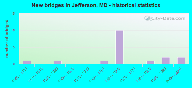
- New bridges - historical statistics
- 11900-1909
- 11920-1929
- 11950-1959
- 101960-1969
- 11980-1989
- 21990-1999
- 22000-2009

- Reconstructed bridges - Historical Statistics
- 11970-1979
- 01980-1989
- 21990-1999
- 02000-2009
- 12010-2019


- Bridge Condition - Deck
- 27.3%Good
- 54.5%Satisfactory
- 18.2%Fair

- Bridge Condition - Superstructure
- 63.6%Good
- 18.2%Satisfactory
- 18.2%Fair

- Bridge Condition - Substructure
- 36.4%Good
- 54.5%Satisfactory
- 9.1%Fair

- Bridge Condition - Channel
- 10.0%Very good
- 40.0%Good
- 40.0%Satisfactory
- 10.0%Fair
Find on map >> Show street view
Structure Number: 10000010008201, Location: 0.55 MILE EAST OF MD 872 (Lat: 39.356883, Lng: -77.572997), Route carried "on" structure: State highway 180, Year Built: 1928, Status: Open, Structure Length: 6.31m (20.70ft), Average Daily Traffic: 4,580 (year 2013), Truck Traffic: 8%, Average Future Daily Traffic: 5,327 (year 2026), Features Intersected: CATOCTIN CREEK
Minimum Vertical Clearance: 30+ m (98+ ft), Kilometerpoint: 9.895, Lanes on structure: 2, Owner: State Highway Agency, Approaching Roadway Width: 9.8m (32.2ft), Material/Design: Concrete, Design/Construction: Arch - Deck, Number Of Spans In Main Unit: 3, Length of Maximum Span: 21.3m (69.9ft), Curb-To-Curb Width: 7.3m (24.0ft), Out-to-Out Width: 8.4m (27.6ft)
Condition: Deck: Fair, Superstructure: Fair, Substructure: Fair, Channel: Satisfactory, Operating Rating: 63.5 metric tons, Method Used To Determine Operating Rating: Load Factor (LF), Inventory Rating: 38.1 metric tons, Method Used To Determine Inventory Rating: Load Factor (LF), Structural Evaluation: Somewhat better than minimum adequacy, Deck Geometry: High priority of replacement, Waterway Adequacy: Better than present minimum criteria, Approach Roadway Alignment: Equal to present desirable criteria, Designated Inspection Frequency: Every 24 months, Inspection Date: August 2020, Deck Structure Type: Concrete Cast-file-Place, Wearing Surface/Protective System: Wearing Surface: Bituminous
Find on map >> Show street view
Structure Number: 10000010008701, Location: 1.52 MILES N OF MD 180 (Lat: 39.368533, Lng: -77.569539), Route carried "on" structure: State highway 383, Year Built: 1953, Year Reconstructed: 1983, Status: Open, Structure Length: 6.28m (20.60ft), Average Daily Traffic: 1,550 (year 2009), Truck Traffic: 8%, Average Future Daily Traffic: 1,799 (year 2026), Design Load: H 20, Features Intersected: CATOCTIN CREEK
Minimum Vertical Clearance: 30+ m (98+ ft), Kilometerpoint: 2.446, Lanes on structure: 2, Owner: State Highway Agency, Approaching Roadway Width: 7.9m (25.9ft), Material/Design: Steel, Design/Construction: Girder and Floorbeam System, Number Of Spans In Main Unit: 3, Length of Maximum Span: 21.0m (68.9ft), Curb-To-Curb Width: 7.9m (25.9ft), Out-to-Out Width: 8.9m (29.2ft)
Condition: Deck: Satisfactory, Superstructure: Satisfactory, Substructure: Satisfactory, Channel: Satisfactory, Operating Rating: 39.5 metric tons, Method Used To Determine Operating Rating: Load Factor (LF), Inventory Rating: 23.6 metric tons, Method Used To Determine Inventory Rating: Load Factor (LF), Structural Evaluation: Equal to present minimum criteria, Deck Geometry: Meets minimum limits, Waterway Adequacy: Equal to present desirable criteria, Approach Roadway Alignment: Equal to present minimum criteria, Designated Inspection Frequency: Every 24 months, Inspection Date: July 2020, Deck Structure Type: Other, Wearing Surface/Protective System: Wearing Surface: Monolithic Concrete, Deck Protection: Epoxy Coated Reinforcing
Find on map >> Show street view
Structure Number: 10000010011201, Location: 0.63 MILE EAST OF MD 180 (Lat: 39.355133, Lng: -77.572289), Route carried "on" structure: US 340, Year Built: 1961, Status: Open, Structure Length: 12.62m (41.40ft), Average Daily Traffic: 28,982 (year 2009), Truck Traffic: 8%, Average Future Daily Traffic: 35,676 (year 2026), Design Load: HS 20, Features Intersected: CATOCTIN CREEK
Minimum Vertical Clearance: 30+ m (98+ ft), Kilometerpoint: 9.863, Lanes on structure: 4, Base Highway Network: Yes, Owner: State Highway Agency, Approaching Roadway Width: 20.7m (67.9ft), Skew: 23 degrees, Material/Design: Steel continuous, Design/Construction: Stringer/Multi-beam, Number Of Spans In Main Unit: 5, Length of Maximum Span: 26.8m (87.9ft), Curb-To-Curb Width: 18.9m (62.0ft), Out-to-Out Width: 20.6m (67.6ft)
Condition: Deck: Fair, Superstructure: Good, Substructure: Satisfactory, Channel: Good, Operating Rating: 41.7 metric tons, Method Used To Determine Operating Rating: Load Factor (LF), Inventory Rating: 24.9 metric tons, Method Used To Determine Inventory Rating: Load Factor (LF), Structural Evaluation: Equal to present minimum criteria, Deck Geometry: Equal to present minimum criteria, Waterway Adequacy: Equal to present desirable criteria, Approach Roadway Alignment: Equal to present desirable criteria, Designated Inspection Frequency: Every 24 months, Inspection Date: September 2020, Deck Structure Type: Concrete Cast-file-Place, Wearing Surface/Protective System: Wearing Surface: Bituminous
Find on map >> Show street view
Structure Number: 10000010011801, Location: 0.13 MILE WEST OF MD 872 (Lat: 39.355783, Lng: -77.583156), Route carried "on" structure: State highway 180, Year Built: 1964, Status: Open, Structure Length: 8.90m (29.20ft), Average Daily Traffic: 4,460 (year 2009), Truck Traffic: 8%, Average Future Daily Traffic: 5,327 (year 2026), Design Load: HS 20, Features Intersected: US 340
Minimum Vertical Clearance: 30+ m (98+ ft), Kilometerpoint: 8.801, Lanes on structure: 2, Lanes under structure: 4, Owner: State Highway Agency, Approaching Roadway Width: 7.3m (24.0ft), Skew: 4 degrees, Material/Design: Steel, Design/Construction: Stringer/Multi-beam, Number Of Spans In Main Unit: 2, Number Of Approach Spans: 2, Length of Maximum Span: 29.9m (98.1ft), Curb-To-Curb Width: 9.1m (29.9ft), Out-to-Out Width: 10.7m (35.1ft)
Condition: Deck: Satisfactory, Superstructure: Good, Substructure: Satisfactory, Inventory Rating: 57.6 metric tons, Method Used To Determine Inventory Rating: Load Factor (LF), Structural Evaluation: Equal to present minimum criteria, Deck Geometry: Meets minimum limits, Underclear: Somewhat better than minimum adequacy, Approach Roadway Alignment: Equal to present desirable criteria, Designated Inspection Frequency: Every 24 months, Inspection Date: January 2020, Deck Structure Type: Concrete Cast-file-Place, Wearing Surface/Protective System: Wearing Surface: Bituminous
Find on map >> Show street view
Structure Number: 10000010011901, Location: 1.85 MI E OF MD 180 (Lat: 39.358189, Lng: -77.549172), Route carried "on" structure: County highway 284, Year Built: 1965, Status: Open, Structure Length: 6.92m (22.70ft), Average Daily Traffic: 148 (year 1994), Truck Traffic: 5%, Average Future Daily Traffic: 174 (year 2012), Design Load: H 20, Features Intersected: US 340, Facility Carried by Structure: HORINE ROAD
Minimum Vertical Clearance: 30+ m (98+ ft), Kilometerpoint: 0.257, Lanes on structure: 2, Lanes under structure: 4, Owner: State Highway Agency, Approaching Roadway Width: 7.3m (24.0ft), Skew: 1 degrees, Material/Design: Steel, Design/Construction: Stringer/Multi-beam, Number Of Spans In Main Unit: 4, Length of Maximum Span: 22.6m (74.1ft), Curb-To-Curb Width: 7.3m (24.0ft), Out-to-Out Width: 8.9m (29.2ft)
Condition: Deck: Satisfactory, Superstructure: Good, Substructure: Good, Operating Rating: 66.2 metric tons, Method Used To Determine Operating Rating: Load Factor (LF), Inventory Rating: 39.9 metric tons, Method Used To Determine Inventory Rating: Load Factor (LF), Structural Evaluation: Better than present minimum criteria, Deck Geometry: Somewhat better than minimum adequacy, Underclear: Somewhat better than minimum adequacy, Approach Roadway Alignment: Equal to present desirable criteria, Designated Inspection Frequency: Every 24 months, Inspection Date: Febuary 2022, Deck Structure Type: Concrete Cast-file-Place, Wearing Surface/Protective System: Wearing Surface: Bituminous
Find on map >> Show street view
Structure Number: 10000010012001, Location: @ US 340 (Lat: 39.359156, Lng: -77.531892), Route carried "on" structure: County highway 281, Year Built: 1965, Status: Open, Structure Length: 7.10m (23.29ft), Average Daily Traffic: 2,734 (year 2006), Truck Traffic: 5%, Average Future Daily Traffic: 3,152 (year 2026), Design Load: HS 20, Features Intersected: US 340, Facility Carried by Structure: LANDER ROAD
Minimum Vertical Clearance: 30+ m (98+ ft), Kilometerpoint: 5.985, Lanes on structure: 2, Lanes under structure: 4, Owner: State Highway Agency, Approaching Roadway Width: 9.1m (29.9ft), Skew: 1 degrees, Material/Design: Steel, Design/Construction: Stringer/Multi-beam, Number Of Spans In Main Unit: 4, Length of Maximum Span: 23.2m (76.1ft), Curb-To-Curb Width: 9.1m (29.9ft), Out-to-Out Width: 10.7m (35.1ft)
Condition: Deck: Satisfactory, Superstructure: Satisfactory, Substructure: Satisfactory, Operating Rating: 58.0 metric tons, Method Used To Determine Operating Rating: Load Factor (LF), Inventory Rating: 34.9 metric tons, Method Used To Determine Inventory Rating: Load Factor (LF), Structural Evaluation: Equal to present minimum criteria, Deck Geometry: Meets minimum limits, Underclear: Meets minimum limits, Approach Roadway Alignment: Equal to present desirable criteria, Designated Inspection Frequency: Every 24 months, Inspection Date: June 2020, Deck Structure Type: Concrete Cast-file-Place, Wearing Surface/Protective System: Wearing Surface: Bituminous
Find on map >> Show street view
Structure Number: 10000010013901, Location: 0.7 MI W OF US 340 (Lat: 39.357150, Lng: -77.505028), Route carried "on" structure: County highway 292, Year Built: 1969, Status: Open, Structure Length: 6.89m (22.60ft), Average Daily Traffic: 999 (year 1994), Truck Traffic: 5%, Average Future Daily Traffic: 295 (year 2012), Design Load: HS 20, Features Intersected: US 15, Facility Carried by Structure: ELMER DERR ROAD
Minimum Vertical Clearance: 30+ m (98+ ft), Kilometerpoint: 0.048, Lanes on structure: 2, Lanes under structure: 2, Owner: State Highway Agency, Approaching Roadway Width: 6.1m (20.0ft), Material/Design: Steel continuous, Design/Construction: Stringer/Multi-beam, Number Of Spans In Main Unit: 2, Length of Maximum Span: 33.8m (110.9ft), Curb-To-Curb Width: 8.8m (28.9ft), Out-to-Out Width: 9.8m (32.2ft)
Condition: Deck: Satisfactory, Superstructure: Good, Substructure: Good, Operating Rating: 55.3 metric tons, Method Used To Determine Operating Rating: Load Factor (LF), Inventory Rating: 33.1 metric tons, Method Used To Determine Inventory Rating: Load Factor (LF), Structural Evaluation: Better than present minimum criteria, Deck Geometry: Somewhat better than minimum adequacy, Underclear: Better than present minimum criteria, Approach Roadway Alignment: Equal to present minimum criteria, Designated Inspection Frequency: Every 24 months, Inspection Date: June 2020, Deck Structure Type: Concrete Cast-file-Place, Wearing Surface/Protective System: Wearing Surface: Monolithic Concrete
Find on map >> Show street view
Structure Number: 200000F-013003, Location: WEST OF HARVARD PLACE (Lat: 39.347992, Lng: -77.498947), Route carried "on" structure: County highway 1977, Year Built: 2002, Status: Open, Structure Length: 0.85m (2.79ft), Average Daily Traffic: 350 (year 2009), Truck Traffic: 5%, Average Future Daily Traffic: 420 (year 2032), Design Load: HS 20, Features Intersected: TRIBUTARY OF TUSCARORA C, Facility Carried by Structure: WINCHESTER BOULEVA
Minimum Vertical Clearance: 30+ m (98+ ft), Kilometerpoint: 0.000, Lanes on structure: 2, Owner: County Highway Agency, Approaching Roadway Width: 12.2m (40.0ft), Skew: 2 degrees, Material/Design: Steel, Design/Construction: Culvert, Number Of Spans In Main Unit: 1, Length of Maximum Span: 8.5m (27.9ft)
Condition: Channel: Good, Culverts: Good, Operating Rating: 45.4 metric tons, Method Used To Determine Operating Rating: Load Factor (LF), Inventory Rating: 27.2 metric tons, Method Used To Determine Inventory Rating: Load Factor (LF), Structural Evaluation: Equal to present minimum criteria, Waterway Adequacy: Equal to present desirable criteria, Approach Roadway Alignment: Equal to present desirable criteria, Designated Inspection Frequency: Every 24 months, Inspection Date: May 2021
Find on map >> Show street view
Structure Number: 200000F-140501, Location: 0.75 MI W OF OLD MIDDLETO (Lat: 39.374203, Lng: -77.550358), Route carried "on" structure: County highway 219, Year Built: 1982, Year Reconstructed: 2001, Status: Open, Structure Length: 1.16m (3.81ft), Average Daily Traffic: 32 (year 2009), Truck Traffic: 5%, Average Future Daily Traffic: 129 (year 2038), Features Intersected: LEWIS MILL BRANCH, Facility Carried by Structure: POFFENBERGER ROAD
Minimum Vertical Clearance: 30+ m (98+ ft), Kilometerpoint: 1.175, Lanes on structure: 2, Owner: County Highway Agency, Approaching Roadway Width: 3.7m (12.1ft), Skew: 2 degrees, Material/Design: Steel, Design/Construction: Stringer/Multi-beam, Number Of Spans In Main Unit: 1, Length of Maximum Span: 10.4m (34.1ft), Curb-To-Curb Width: 6.1m (20.0ft), Out-to-Out Width: 6.1m (20.0ft)
Condition: Deck: Good, Superstructure: Good, Substructure: Satisfactory, Channel: Fair, Operating Rating: 64.4 metric tons, Method Used To Determine Operating Rating: Load Factor (LF), Inventory Rating: 38.5 metric tons, Method Used To Determine Inventory Rating: Load Factor (LF), Structural Evaluation: Equal to present minimum criteria, Deck Geometry: Somewhat better than minimum adequacy, Waterway Adequacy: Better than present minimum criteria, Approach Roadway Alignment: Equal to present minimum criteria, Designated Inspection Frequency: Every 24 months, Inspection Date: May 2020, Deck Structure Type: Wood or Timber
Find on map >> Show street view
Structure Number: 200000F-141003, Location: 1.62 MI N OF MD RTE 180 (Lat: 39.386025, Lng: -77.538422), Route carried "on" structure: County highway 209, Year Built: 1962, Year Reconstructed: 2010, Status: Open, Structure Length: 0.82m (2.69ft), Average Daily Traffic: 2,532 (year 2009), Truck Traffic: 5%, Average Future Daily Traffic: 3,038 (year 2032), Features Intersected: LEWIS MILL BRANCH, Facility Carried by Structure: OLD MIDDLETOWN RD
Minimum Vertical Clearance: 30+ m (98+ ft), Kilometerpoint: 5.696, Lanes on structure: 2, Owner: County Highway Agency, Approaching Roadway Width: 6.1m (20.0ft), Skew: 1 degrees, Material/Design: Steel, Design/Construction: Culvert, Length of Maximum Span: 0.0m
Condition: Channel: Good, Culverts: Good, Structural Evaluation: Better than present minimum criteria, Waterway Adequacy: Better than present minimum criteria, Approach Roadway Alignment: Equal to present desirable criteria, Designated Inspection Frequency: Every 24 months, Inspection Date: April 2020
Find on map >> Show street view
Structure Number: 200000F-220401, Location: 1.5 MI W OLD MIDDLETOWN R (Lat: 39.395278, Lng: -77.562444), Route carried "on" structure: County highway 218, Year Built: 1900, Year Reconstructed: 1999, Status: Posted for load, Structure Length: 3.08m (10.10ft), Average Daily Traffic: 124 (year 2020), Truck Traffic: 5%, Average Future Daily Traffic: 185 (year 2040), Features Intersected: CATOCTIN CREEK, Facility Carried by Structure: SUMANTOWN ROAD
Minimum Vertical Clearance: 30+ m (98+ ft), Kilometerpoint: 2.285, Lanes on structure: 1, Owner: County Highway Agency, Approaching Roadway Width: 3.4m (11.2ft), Material/Design: Steel, Design/Construction: Truss - Thru, Number Of Spans In Main Unit: 1, Length of Maximum Span: 30.8m (101.0ft), Curb-To-Curb Width: 4.5m (14.8ft), Out-to-Out Width: 4.7m (15.4ft)
Condition: Deck: Satisfactory, Superstructure: Fair, Substructure: Satisfactory, Channel: Satisfactory, Operating Rating: 27.2 metric tons, Method Used To Determine Operating Rating: Load Factor (LF), Inventory Rating: 16.3 metric tons, Method Used To Determine Inventory Rating: Load Factor (LF), Structural Evaluation: Somewhat better than minimum adequacy, Deck Geometry: High priority of replacement, Waterway Adequacy: Better than present minimum criteria, Approach Roadway Alignment: Equal to present desirable criteria, Bridge Posting: Required (Relationship of Operating Rating to Maximum Legal Load: > 39.9% below), Length Of Structure Improvement: 3.08m (10.10ft), Designated Inspection Frequency: Every 12 months, Critical Feature Inspection Frequency: Every 12 months, Inspection Date: September 2021, Critical Feature Inspection Date: September 2021, Deck Structure Type: Wood or Timber
Find on map >> Show street view
Structure Number: 200000HO018901, Location: .02 Mi N of MD 32 (Lat: 39.393297, Lng: -77.536092), Route carried "on" structure: County highway , Year Built: 1994, Status: Open, Structure Length: 8.01m (26.28ft), Average Daily Traffic: 17,121 (year 2000), Truck Traffic: 8%, Average Future Daily Traffic: 19,700 (year 2015), Design Load: HS 25 or greater, Features Intersected: MIDDLE PATUXENT RIVER, Facility Carried by Structure: CEDAR LANE
Minimum Vertical Clearance: 30+ m (98+ ft), Kilometerpoint: 0.000, Lanes on structure: 5, Owner: County Highway Agency, Approaching Roadway Width: 14.6m (47.9ft), Skew: 3 degrees, Material/Design: Steel continuous, Design/Construction: Stringer/Multi-beam, Number Of Spans In Main Unit: 2, Length of Maximum Span: 39.6m (129.9ft), Curb-To-Curb Width: 20.7m (67.9ft), Out-to-Out Width: 21.9m (71.9ft)
Condition: Deck: Good, Superstructure: Good, Substructure: Good, Channel: Satisfactory, Operating Rating: 87.1 metric tons, Method Used To Determine Operating Rating: Load Factor (LF), Inventory Rating: 52.2 metric tons, Method Used To Determine Inventory Rating: Load Factor (LF), Structural Evaluation: Better than present minimum criteria, Deck Geometry: Somewhat better than minimum adequacy, Waterway Adequacy: Superior to present desirable criteria, Approach Roadway Alignment: Equal to present desirable criteria, Designated Inspection Frequency: Every 24 months, Inspection Date: March 2020, Deck Structure Type: Concrete Cast-file-Place, Wearing Surface/Protective System: Wearing Surface: Monolithic Concrete, Deck Protection: Epoxy Coated Reinforcing
Find on map >> Show street view
Structure Number: 200000HO019501, Location: 1.0 Mile SE of MD 108 (Lat: 39.335267, Lng: -77.550639), Route carried "on" structure: County highway , Year Built: 1997, Status: Open, Structure Length: 2.35m (7.71ft), Average Daily Traffic: 6,583 (year 2000), Average Future Daily Traffic: 10,177 (year 2022), Design Load: HS 25 or greater, Features Intersected: CRICKETT CREEK, Facility Carried by Structure: GREAT STAR DRIVE
Minimum Vertical Clearance: 30+ m (98+ ft), Kilometerpoint: 0.000, Lanes on structure: 2, Owner: County Highway Agency, Approaching Roadway Width: 11.6m (38.1ft), Material/Design: Steel, Design/Construction: Stringer/Multi-beam, Number Of Spans In Main Unit: 1, Length of Maximum Span: 22.3m (73.2ft), Curb or Sidewalk Widths: Left: 0.0m, Right: 1.6m (5.2ft), Curb-To-Curb Width: 11.6m (38.1ft), Out-to-Out Width: 13.9m (45.6ft)
Condition: Deck: Good, Superstructure: Good, Substructure: Good, Channel: Good, Inventory Rating: 70.7 metric tons, Method Used To Determine Inventory Rating: Load Factor (LF), Structural Evaluation: Better than present minimum criteria, Deck Geometry: Somewhat better than minimum adequacy, Waterway Adequacy: Equal to present desirable criteria, Approach Roadway Alignment: Equal to present desirable criteria, Designated Inspection Frequency: Every 24 months, Inspection Date: April 2020, Deck Structure Type: Concrete Cast-file-Place
Find on map >> Show street view
Structure Number: 200000HO026303, Location: 200 ft East of S Trotter (Lat: 39.325494, Lng: -77.539042), Route carried "on" structure: County highway , Year Built: 2000, Status: Open, Structure Length: 0.85m (2.79ft), Average Daily Traffic: 50 (year 2016), Average Future Daily Traffic: 50 (year 2037), Features Intersected: TRIB MIDDLE PATUXENT R, Facility Carried by Structure: SWIMMER ROW WAY
Minimum Vertical Clearance: 30+ m (98+ ft), Kilometerpoint: 0.000, Lanes on structure: 2, Owner: County Highway Agency, Approaching Roadway Width: 6.1m (20.0ft), Skew: 1 degrees, Material/Design: Concrete, Design/Construction: Culvert, Length of Maximum Span: 1.2m (3.9ft), Curb or Sidewalk Widths: Left: 1.2m (3.9ft), Right: 0.0m
Condition: Channel: Very good, Culverts: Good, Operating Rating: 32.7 metric tons, Method Used To Determine Operating Rating: Field evaluation and documented engineering judgment, Inventory Rating: 32.7 metric tons, Method Used To Determine Inventory Rating: Field evaluation and documented engineering judgment, Structural Evaluation: Better than present minimum criteria, Waterway Adequacy: Equal to present desirable criteria, Approach Roadway Alignment: Equal to present desirable criteria, Designated Inspection Frequency: Every 24 months, Inspection Date: Febuary 2020
Find on map >> Show street view
Structure Number: 10000010011801, Location: 3.38 MILES EAST OF MD 17 (Lat: 39.355783, Lng: -77.583156), Route carried "under" structure: US 340, Year Built: 1964, Structure Length: 0. m, Average Daily Traffic: 28,982 (year 2009), Features Intersected: US 340, Facility Carried by Structure: MD 180
Minimum Vertical Clearance: 4.88m (16.01ft), Kilometerpoint: 8.850, Lanes on structure: 2, Lanes under structure: 4, Material/Design: Steel, Design/Construction: Stringer/Multi-beam, Length of Maximum Span: 29.9m (98.1ft)
Find on map >> Show street view
Structure Number: 10000010011901, Location: 0.94 M W OF LANDER ROAD (Lat: 39.358189, Lng: -77.549172), Route carried "under" structure: US 340, Year Built: 1965, Structure Length: 0. m, Average Daily Traffic: 28,982 (year 2009), Features Intersected: US 340, Facility Carried by Structure: HORINE ROAD
Minimum Vertical Clearance: 4.88m (16.01ft), Kilometerpoint: 11.842, Lanes on structure: 2, Lanes under structure: 4, Material/Design: Steel, Design/Construction: Stringer/Multi-beam, Length of Maximum Span: 22.6m (74.1ft)
Find on map >> Show street view
Structure Number: 10000010012001, Location: 0.94 M E OF HORINE ROAD (Lat: 39.359156, Lng: -77.531892), Route carried "under" structure: US 340, Year Built: 1965, Structure Length: 0. m, Average Daily Traffic: 32,282 (year 2009), Features Intersected: US 340, Facility Carried by Structure: LANDER ROAD
Minimum Vertical Clearance: 4.88m (16.01ft), Kilometerpoint: 13.355, Lanes on structure: 2, Lanes under structure: 4, Material/Design: Steel, Design/Construction: Stringer/Multi-beam, Length of Maximum Span: 23.2m (76.1ft)
Find on map >> Show street view
Structure Number: 10000010013901, Location: 0.46 MILE SOUTH OF US 340 (Lat: 39.357150, Lng: -77.505028), Route carried "under" structure: US 15, Year Built: 1969, Structure Length: 0. m, Average Daily Traffic: 16,060 (year 2009), Features Intersected: US 15, Facility Carried by Structure: ELMER DERR ROAD
Minimum Vertical Clearance: 4.88m (16.01ft), Kilometerpoint: 10.571, Lanes on structure: 2, Lanes under structure: 4, Material/Design: Steel continuous, Design/Construction: Stringer/Multi-beam, Length of Maximum Span: 33.8m (110.9ft)