Bridge Statistics for Jasper, Michigan (MI)
Condition, Traffic, Stress, Structural Evaluation, Project Costs
- National Bridge Inventory (NBI) Statistics
- 24Number of bridges
- 135ft / 41.1mTotal length
- $570,000Total costs
- 13,415Total average daily traffic
- 1,018Total average daily truck traffic
- 19,242Total future (year 2018) average daily traffic
- National Bridge Inventory (NBI) Registered Bridges for Jasper
- No street view available for this location
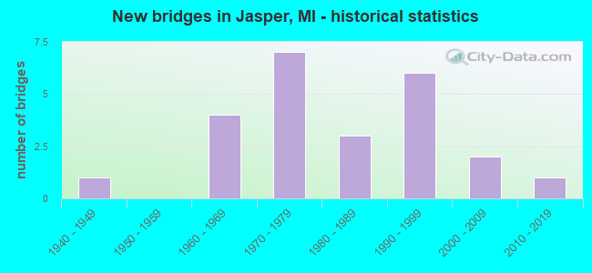
- New bridges - historical statistics
- 11940-1949
- 41960-1969
- 71970-1979
- 31980-1989
- 61990-1999
- 22000-2009
- 12010-2019

- Reconstructed bridges - Historical Statistics
- 11990-1999
- 32000-2009


- Bridge Condition - Deck
- 29.2%Very good
- 29.2%Good
- 25.0%Satisfactory
- 16.7%Fair

- Bridge Condition - Superstructure
- 33.3%Very good
- 20.8%Good
- 20.8%Satisfactory
- 8.3%Fair
- 4.2%Poor
- 8.3%Serious
- 4.2%Failed

- Bridge Condition - Substructure
- 37.5%Very good
- 54.2%Good
- 4.2%Satisfactory
- 4.2%Fair

- Bridge Condition - Channel
- 29.2%Good
- 50.0%Satisfactory
- 20.8%Fair
Find on map >> Show street view
Structure Number: 5524, Location: 1.4 MI N OHIO STATE LINE (Lat: 41.736119, Lng: -84.038242), Route carried "on" structure: State highway 52, Year Built: 1963, Status: Open, Structure Length: 1.22m (4.00ft), Average Daily Traffic: 3,862 (year 2007), Truck Traffic: 12%, Average Future Daily Traffic: 3,821 (year 2018), Design Load: HS 20, Features Intersected: NILE DITCH
Minimum Vertical Clearance: 30.48m (100.00ft), Kilometerpoint: 2.223, Lanes on structure: 2, Base Highway Network: Yes (Inventory Route: 94, Subroute: 6), Owner: State Highway Agency, Approaching Roadway Width: 12.2m (40.0ft), Material/Design: Concrete, Design/Construction: Tee Beam, Number Of Spans In Main Unit: 1, Length of Maximum Span: 12.2m (40.0ft), Curb or Sidewalk Widths: Left: 0.4m (1.3ft), Right: 0.4m (1.3ft), Curb-To-Curb Width: 12.2m (40.0ft), Out-to-Out Width: 13.8m (45.3ft)
Condition: Deck: Satisfactory, Superstructure: Very good, Substructure: Satisfactory, Channel: Satisfactory, Operating Rating: 68.4 metric tons, Method Used To Determine Operating Rating: Load Factor (LF) rating reported by rating factor (RF) method using MS18 loading, Inventory Rating: 41.1 metric tons, Method Used To Determine Inventory Rating: Load Factor (LF) rating reported by rating factor (RF) method using MS18 loading, Structural Evaluation: Equal to present minimum criteria, Deck Geometry: Equal to present minimum criteria, Waterway Adequacy: Equal to present desirable criteria, Approach Roadway Alignment: Equal to present desirable criteria, Designated Inspection Frequency: Every 24 months, Inspection Date: July 2020, Deck Structure Type: Concrete Cast-file-Place, Wearing Surface/Protective System: Wearing Surface: Monolithic Concrete
Find on map >> Show street view
Structure Number: 5525, Location: 0.5 MI S OF JASPER (Lat: 41.786403, Lng: -84.040344), Route carried "on" structure: State highway 52, Year Built: 1947, Year Reconstructed: 2006, Status: Open, Structure Length: 1.52m (4.99ft), Average Daily Traffic: 3,862 (year 2007), Truck Traffic: 12%, Average Future Daily Traffic: 3,821 (year 2018), Design Load: HS 20, Features Intersected: BLACK CREEK
Minimum Vertical Clearance: 30.48m (100.00ft), Kilometerpoint: 7.809, Lanes on structure: 2, Owner: State Highway Agency, Approaching Roadway Width: 12.2m (40.0ft), Material/Design: Prestressed concrete, Design/Construction: Stringer/Multi-beam, Number Of Spans In Main Unit: 1, Length of Maximum Span: 14.1m (46.3ft), Curb-To-Curb Width: 13.4m (44.0ft), Out-to-Out Width: 14.4m (47.2ft)
Condition: Deck: Good, Superstructure: Very good, Substructure: Good, Channel: Satisfactory, Operating Rating: 71.0 metric tons, Method Used To Determine Operating Rating: Load Factor (LF) rating reported by rating factor (RF) method using MS18 loading, Inventory Rating: 31.8 metric tons, Method Used To Determine Inventory Rating: Load Factor (LF) rating reported by rating factor (RF) method using MS18 loading, Structural Evaluation: Better than present minimum criteria, Deck Geometry: Better than present minimum criteria, Waterway Adequacy: Equal to present minimum criteria, Approach Roadway Alignment: Equal to present desirable criteria, Designated Inspection Frequency: Every 24 months, Inspection Date: July 2020, Deck Structure Type: Concrete Cast-file-Place, Wearing Surface/Protective System: Wearing Surface: Monolithic Concrete, Deck Protection: Epoxy Coated Reinforcing
Find on map >> Show street view
Structure Number: 5548, Location: 0.75 MI EAST OF M-52 (Lat: 41.742611, Lng: -84.023075), Route carried "on" structure: County highway 4610, Year Built: 1974, Status: Closed, Structure Length: 0.91m (2.99ft), Average Daily Traffic: 34 (year 2012), Truck Traffic: 2%, Average Future Daily Traffic: 175 (year 2031), Features Intersected: NILE CREEK, Facility Carried by Structure: MULBERRY ROAD
Minimum Vertical Clearance: 30.48m (100.00ft), Kilometerpoint: 10.173, Lanes on structure: 2, Owner: County Highway Agency, Approaching Roadway Width: 10.1m (33.1ft), Material/Design: Steel, Design/Construction: Stringer/Multi-beam, Number Of Spans In Main Unit: 1, Length of Maximum Span: 9.1m (29.9ft), Curb-To-Curb Width: 7.9m (25.9ft), Out-to-Out Width: 8.9m (29.2ft)
Condition: Deck: Fair, Superstructure: Serious, Substructure: Good, Channel: Fair, Deck Geometry: Equal to present minimum criteria, Waterway Adequacy: Better than present minimum criteria, Approach Roadway Alignment: Better than present minimum criteria, Bridge Posting: Required (Relationship of Operating Rating to Maximum Legal Load: > 39.9% below), Length Of Structure Improvement: 0.91m (2.99ft), Designated Inspection Frequency: Every 24 months, Inspection Date: May 2021, Bridge Improvement Cost: $50,000, Roadway Improvement Cost: $10,000, Total Project Cost: $60,000, Deck Structure Type: Corrugated Steel, Wearing Surface/Protective System: Wearing Surface: Bituminous, Deck Protection: Other
Find on map >> Show street view
Structure Number: 5549, Location: 0.1 MI WEST OF HODGES HWY (Lat: 41.742753, Lng: -83.977581), Route carried "on" structure: County highway 4610, Year Built: 1977, Status: Open, Structure Length: 1.22m (4.00ft), Average Daily Traffic: 70 (year 2012), Truck Traffic: 1%, Average Future Daily Traffic: 175 (year 2031), Design Load: H 20, Features Intersected: BEAR CREEK, Facility Carried by Structure: MULBERRY ROAD
Minimum Vertical Clearance: 30.48m (100.00ft), Kilometerpoint: 1.835, Lanes on structure: 2, Owner: County Highway Agency, Approaching Roadway Width: 7.9m (25.9ft), Material/Design: Prestressed concrete, Design/Construction: Tee Beam, Number Of Spans In Main Unit: 1, Length of Maximum Span: 11.6m (38.1ft), Curb-To-Curb Width: 8.8m (28.9ft), Out-to-Out Width: 9.1m (29.9ft)
Condition: Deck: Satisfactory, Superstructure: Satisfactory, Substructure: Good, Channel: Satisfactory, Operating Rating: 39.5 metric tons, Method Used To Determine Operating Rating: Load Factor (LF), Inventory Rating: 23.7 metric tons, Method Used To Determine Inventory Rating: Load Factor (LF), Structural Evaluation: Equal to present minimum criteria, Deck Geometry: Better than present minimum criteria, Waterway Adequacy: Equal to present minimum criteria, Approach Roadway Alignment: Equal to present desirable criteria, Designated Inspection Frequency: Every 24 months, Inspection Date: April 2021, Deck Structure Type: Concrete Precast Panels, Wearing Surface/Protective System: Wearing Surface: Bituminous
Find on map >> Show street view
Structure Number: 5555, Location: 0.25 MI EAST OF M-52 (Lat: 41.771489, Lng: -84.033550), Route carried "on" structure: County highway 4608, Year Built: 1990, Status: Open, Structure Length: 1.95m (6.40ft), Average Daily Traffic: 708 (year 2010), Truck Traffic: 5%, Average Future Daily Traffic: 1,600 (year 2031), Design Load: HS 20, Features Intersected: NILE CREEK, Facility Carried by Structure: WESTON RD
Minimum Vertical Clearance: 30.48m (100.00ft), Kilometerpoint: 8.614, Lanes on structure: 2, Owner: County Highway Agency, Approaching Roadway Width: 10.1m (33.1ft), Skew: 1 degrees, Material/Design: Prestressed concrete, Design/Construction: Box Beam or Girders - Multiple, Number Of Spans In Main Unit: 1, Length of Maximum Span: 19.5m (64.0ft), Curb-To-Curb Width: 10.1m (33.1ft), Out-to-Out Width: 11.3m (37.1ft)
Condition: Deck: Good, Superstructure: Good, Substructure: Good, Channel: Satisfactory, Operating Rating: 59.0 metric tons, Method Used To Determine Operating Rating: Load Factor (LF), Inventory Rating: 35.4 metric tons, Method Used To Determine Inventory Rating: Load Factor (LF), Structural Evaluation: Better than present minimum criteria, Deck Geometry: Equal to present minimum criteria, Waterway Adequacy: Equal to present desirable criteria, Approach Roadway Alignment: Equal to present desirable criteria, Designated Inspection Frequency: Every 24 months, Inspection Date: January 2022, Deck Structure Type: Concrete Precast Panels, Wearing Surface/Protective System: Wearing Surface: Bituminous
Find on map >> Show street view
Structure Number: 5558, Location: 0.1 MI EAST OF LYONS HWY (Lat: 41.785281, Lng: -84.078564), Route carried "on" structure: County highway , Year Built: 2015, Status: Open, Structure Length: 1.28m (4.20ft), Average Daily Traffic: 398 (year 2014), Truck Traffic: 1%, Average Future Daily Traffic: 1,000 (year 2034), Design Load: Greater than HL93, Features Intersected: BAKER & MAY DRAIN, Facility Carried by Structure: PACKARD RD
Minimum Vertical Clearance: 30.48m (100.00ft), Kilometerpoint: 23.494, Lanes on structure: 2, Owner: County Highway Agency, Approaching Roadway Width: 8.5m (27.9ft), Material/Design: Prestressed concrete, Design/Construction: Box Beam or Girders - Multiple, Number Of Spans In Main Unit: 1, Length of Maximum Span: 12.4m (40.7ft), Curb-To-Curb Width: 8.7m (28.5ft), Out-to-Out Width: 9.7m (31.8ft)
Condition: Deck: Very good, Superstructure: Very good, Substructure: Very good, Channel: Good, Operating Rating: 76.8 metric tons, Method Used To Determine Operating Rating: Load and Resistance Factor Rating (LRFR) rating reported by rating factor(RF) method using HL-93 loadings, Inventory Rating: 58.0 metric tons, Method Used To Determine Inventory Rating: Load and Resistance Factor Rating (LRFR) rating reported by rating factor(RF) method using HL-93 loadings, Structural Evaluation: Equal to present desirable criteria, Deck Geometry: Equal to present minimum criteria, Waterway Adequacy: Equal to present desirable criteria, Approach Roadway Alignment: Equal to present minimum criteria, Designated Inspection Frequency: Every 24 months, Inspection Date: October 2021, Deck Structure Type: Concrete Cast-file-Place, Wearing Surface/Protective System: Wearing Surface: Monolithic Concrete, Deck Protection: Epoxy Coated Reinforcing
Find on map >> Show street view
Structure Number: 5584, Location: 0.3 MI NORTH OF WESTON RD (Lat: 41.773742, Lng: -84.098139), Route carried "on" structure: County highway 4643, Year Built: 1963, Status: Posted for load, Structure Length: 2.25m (7.38ft), Average Daily Traffic: 544 (year 2018), Truck Traffic: 2%, Average Future Daily Traffic: 800 (year 2038), Design Load: H 20, Features Intersected: BLACK CREEK, Facility Carried by Structure: SAND CREEK HWY
Minimum Vertical Clearance: 30.48m (100.00ft), Kilometerpoint: 6.608, Lanes on structure: 2, Owner: County Highway Agency, Approaching Roadway Width: 9.1m (29.9ft), Skew: 4 degrees, Material/Design: Steel, Design/Construction: Stringer/Multi-beam, Number Of Spans In Main Unit: 2, Length of Maximum Span: 11.2m (36.7ft), Curb or Sidewalk Widths: Left: 0.3m (1.0ft), Right: 0.3m (1.0ft), Curb-To-Curb Width: 9.1m (29.9ft), Out-to-Out Width: 9.7m (31.8ft)
Condition: Deck: Fair, Superstructure: Poor, Substructure: Good, Channel: Satisfactory, Operating Rating: 23.7 metric tons, Method Used To Determine Operating Rating: Load Factor (LF) rating reported by rating factor (RF) method using MS18 loading, Inventory Rating: 14.3 metric tons, Method Used To Determine Inventory Rating: Load Factor (LF) rating reported by rating factor (RF) method using MS18 loading, Structural Evaluation: Meets minimum limits, Deck Geometry: Equal to present minimum criteria, Waterway Adequacy: Superior to present desirable criteria, Approach Roadway Alignment: Equal to present desirable criteria, Bridge Posting: Required (Relationship of Operating Rating to Maximum Legal Load: > 39.9% below), Length Of Structure Improvement: 2.25m (7.38ft), Designated Inspection Frequency: Every 6 months, Inspection Date: January 2022, Bridge Improvement Cost: $70,000, Total Project Cost: $70,000, Deck Structure Type: Concrete Cast-file-Place, Wearing Surface/Protective System: Wearing Surface: Monolithic Concrete
Find on map >> Show street view
Structure Number: 5585, Location: 0.1 MI NORTH OF LIVESAY (Lat: 41.829939, Lng: -84.100050), Route carried "on" structure: County highway 4643, Year Built: 1963, Status: Closed, Structure Length: 2.62m (8.60ft), Average Daily Traffic: 736 (year 2012), Truck Traffic: 1%, Average Future Daily Traffic: 2,000 (year 2031), Design Load: H 20, Features Intersected: RIVER RAISIN SOUTH BR, Facility Carried by Structure: SAND CREEK HWY
Minimum Vertical Clearance: 30.48m (100.00ft), Kilometerpoint: 3.583, Lanes on structure: 2, Owner: County Highway Agency, Approaching Roadway Width: 9.1m (29.9ft), Skew: 3 degrees, Material/Design: Steel, Design/Construction: Stringer/Multi-beam, Number Of Spans In Main Unit: 2, Length of Maximum Span: 13.1m (43.0ft), Curb or Sidewalk Widths: Left: 0.3m (1.0ft), Right: 0.3m (1.0ft), Curb-To-Curb Width: 7.3m (24.0ft), Out-to-Out Width: 9.7m (31.8ft)
Condition: Deck: Fair, Superstructure: Failed, Substructure: Good, Channel: Good, Deck Geometry: Meets minimum limits, Waterway Adequacy: Equal to present desirable criteria, Approach Roadway Alignment: Equal to present minimum criteria, Bridge Posting: Required (Relationship of Operating Rating to Maximum Legal Load: > 39.9% below), Length Of Structure Improvement: 3.29m (10.79ft), Designated Inspection Frequency: Every 24 months, Inspection Date: April 2020, Bridge Improvement Cost: $400,000, Roadway Improvement Cost: $40,000, Total Project Cost: $440,000, Deck Structure Type: Concrete Cast-file-Place, Wearing Surface/Protective System: Wearing Surface: Monolithic Concrete
Find on map >> Show street view
Structure Number: 5586, Location: 0.5 MI S OF RIDGEVILLE (Lat: 41.750028, Lng: -83.977461), Route carried "on" structure: County highway , Year Built: 1991, Status: Open, Structure Length: 1.95m (6.40ft), Average Daily Traffic: 61 (year 2012), Truck Traffic: 1%, Average Future Daily Traffic: 250 (year 2031), Design Load: HS 20, Features Intersected: BEAR CREEK, Facility Carried by Structure: HODGES HWY
Minimum Vertical Clearance: 30.48m (100.00ft), Kilometerpoint: 3.679, Lanes on structure: 2, Owner: County Highway Agency, Approaching Roadway Width: 7.9m (25.9ft), Material/Design: Wood or Timber, Design/Construction: Slab, Number Of Spans In Main Unit: 3, Length of Maximum Span: 8.5m (27.9ft), Curb-To-Curb Width: 0.9m (3.0ft), Out-to-Out Width: 9.5m (31.2ft)
Condition: Deck: Very good, Superstructure: Very good, Substructure: Very good, Channel: Good, Operating Rating: 46.5 metric tons, Method Used To Determine Operating Rating: Allowable Stress (AS), Inventory Rating: 33.6 metric tons, Method Used To Determine Inventory Rating: Load Factor (LF), Structural Evaluation: Equal to present desirable criteria, Deck Geometry: High priority of replacement, Waterway Adequacy: Better than present minimum criteria, Approach Roadway Alignment: Equal to present desirable criteria, Designated Inspection Frequency: Every 24 months, Inspection Date: April 2021, Deck Structure Type: Wood or Timber, Wearing Surface/Protective System: Wearing Surface: Bituminous, Deck Protection: Internally Sealed
Find on map >> Show street view
Structure Number: 5587, Location: 0.2 MI NORTH OF HORTON RD (Lat: 41.802922, Lng: -83.979461), Route carried "on" structure: County highway , Year Built: 1975, Status: Open, Structure Length: 2.43m (7.97ft), Average Daily Traffic: 411 (year 2012), Truck Traffic: 2%, Average Future Daily Traffic: 850 (year 2031), Design Load: H 20, Features Intersected: BLACK CREEK, Facility Carried by Structure: HODGES HWY
Minimum Vertical Clearance: 30.48m (100.00ft), Kilometerpoint: 9.555, Lanes on structure: 2, Owner: County Highway Agency, Approaching Roadway Width: 11.6m (38.1ft), Material/Design: Prestressed concrete, Design/Construction: Box Beam or Girders - Multiple, Number Of Spans In Main Unit: 2, Length of Maximum Span: 12.2m (40.0ft), Curb-To-Curb Width: 8.8m (28.9ft), Out-to-Out Width: 9.5m (31.2ft)
Condition: Deck: Good, Superstructure: Satisfactory, Substructure: Good, Channel: Fair, Operating Rating: 46.3 metric tons, Method Used To Determine Operating Rating: Load Factor (LF), Inventory Rating: 27.8 metric tons, Method Used To Determine Inventory Rating: Load Factor (LF), Structural Evaluation: Equal to present minimum criteria, Deck Geometry: Somewhat better than minimum adequacy, Waterway Adequacy: Equal to present minimum criteria, Approach Roadway Alignment: Equal to present desirable criteria, Designated Inspection Frequency: Every 24 months, Inspection Date: April 2021, Deck Structure Type: Concrete Precast Panels, Wearing Surface/Protective System: Wearing Surface: Bituminous
Find on map >> Show street view
Structure Number: 5633, Location: 0.2 MI W OF MORSE HWY (Lat: 41.785386, Lng: -84.062603), Route carried "on" structure: County highway , Year Built: 1996, Status: Open, Structure Length: 2.43m (7.97ft), Average Daily Traffic: 72 (year 2010), Average Future Daily Traffic: 200 (year 2031), Design Load: HS 20, Features Intersected: BLACK CREEK, Facility Carried by Structure: PACKARD RD
Minimum Vertical Clearance: 30.48m (100.00ft), Kilometerpoint: 24.823, Lanes on structure: 2, Owner: County Highway Agency, Approaching Roadway Width: 10.1m (33.1ft), Material/Design: Prestressed concrete, Design/Construction: Box Beam or Girders - Multiple, Number Of Spans In Main Unit: 1, Length of Maximum Span: 24.3m (79.7ft), Curb-To-Curb Width: 9.1m (29.9ft), Out-to-Out Width: 9.4m (30.8ft)
Condition: Deck: Satisfactory, Superstructure: Satisfactory, Substructure: Very good, Channel: Satisfactory, Operating Rating: 69.4 metric tons, Method Used To Determine Operating Rating: Load Factor (LF), Inventory Rating: 41.6 metric tons, Method Used To Determine Inventory Rating: Load Factor (LF), Structural Evaluation: Equal to present minimum criteria, Deck Geometry: Better than present minimum criteria, Waterway Adequacy: Equal to present minimum criteria, Approach Roadway Alignment: Equal to present desirable criteria, Designated Inspection Frequency: Every 24 months, Inspection Date: May 2020, Deck Structure Type: Concrete Cast-file-Place, Wearing Surface/Protective System: Wearing Surface: Monolithic Concrete, Deck Protection: Epoxy Coated Reinforcing
Find on map >> Show street view
Structure Number: 5634, Location: 0.2 MI E OF BAKER HWY (Lat: 41.786239, Lng: -84.016025), Route carried "on" structure: County highway , Year Built: 1990, Status: Open, Structure Length: 2.31m (7.58ft), Average Daily Traffic: 93 (year 2006), Truck Traffic: 1%, Average Future Daily Traffic: 150 (year 2026), Design Load: HS 20, Features Intersected: BLACK CREEK, Facility Carried by Structure: FIKE ROAD
Minimum Vertical Clearance: 30.48m (100.00ft), Kilometerpoint: 0.398, Lanes on structure: 2, Owner: County Highway Agency, Approaching Roadway Width: 9.1m (29.9ft), Material/Design: Prestressed concrete, Design/Construction: Box Beam or Girders - Multiple, Number Of Spans In Main Unit: 1, Length of Maximum Span: 22.5m (73.8ft), Curb-To-Curb Width: 9.1m (29.9ft), Out-to-Out Width: 9.4m (30.8ft)
Condition: Deck: Good, Superstructure: Good, Substructure: Very good, Channel: Fair, Operating Rating: 68.2 metric tons, Method Used To Determine Operating Rating: Load Factor (LF), Inventory Rating: 40.9 metric tons, Method Used To Determine Inventory Rating: Load Factor (LF), Structural Evaluation: Better than present minimum criteria, Deck Geometry: Better than present minimum criteria, Waterway Adequacy: Equal to present desirable criteria, Approach Roadway Alignment: Equal to present desirable criteria, Designated Inspection Frequency: Every 24 months, Inspection Date: May 2020, Deck Structure Type: Concrete Precast Panels, Wearing Surface/Protective System: Wearing Surface: Bituminous, Membrane: Other, Deck Protection: Epoxy Coated Reinforcing
Find on map >> Show street view
Structure Number: 5635, Location: 0.3 MI N OF WESTON RD (Lat: 41.773789, Lng: -84.117928), Route carried "on" structure: County highway , Year Built: 1987, Status: Open, Structure Length: 1.15m (3.77ft), Average Daily Traffic: 40 (year 2006), Truck Traffic: 1%, Average Future Daily Traffic: 150 (year 2026), Design Load: HS 20, Features Intersected: BLACK CREEK, Facility Carried by Structure: TERRY HWY
Minimum Vertical Clearance: 30.48m (100.00ft), Kilometerpoint: 5.258, Lanes on structure: 2, Owner: County Highway Agency, Approaching Roadway Width: 6.1m (20.0ft), Material/Design: Wood or Timber, Design/Construction: Stringer/Multi-beam, Number Of Spans In Main Unit: 2, Length of Maximum Span: 5.7m (18.7ft), Curb-To-Curb Width: 7.0m (23.0ft), Out-to-Out Width: 7.7m (25.3ft)
Condition: Deck: Good, Superstructure: Good, Substructure: Good, Channel: Fair, Operating Rating: 66.0 metric tons, Method Used To Determine Operating Rating: Allowable Stress (AS), Inventory Rating: 47.6 metric tons, Method Used To Determine Inventory Rating: Allowable Stress (AS), Structural Evaluation: Better than present minimum criteria, Deck Geometry: Somewhat better than minimum adequacy, Waterway Adequacy: Better than present minimum criteria, Approach Roadway Alignment: Better than present minimum criteria, Designated Inspection Frequency: Every 24 months, Inspection Date: December 2021, Deck Structure Type: Wood or Timber, Wearing Surface/Protective System: Wearing Surface: Bituminous
Find on map >> Show street view
Structure Number: 5637, Location: 0.4 MI S OF PACKARD RD (Lat: 41.779311, Lng: -84.079058), Route carried "on" structure: County highway , Year Built: 2009, Status: Open, Structure Length: 2.01m (6.59ft), Average Daily Traffic: 1,117 (year 2009), Truck Traffic: 2%, Average Future Daily Traffic: 1,500 (year 2029), Design Load: HS 20+Mod, Features Intersected: BLACK CREEK, Facility Carried by Structure: LYONS HWY
Minimum Vertical Clearance: 30.48m (100.00ft), Kilometerpoint: 7.242, Lanes on structure: 2, Owner: County Highway Agency, Approaching Roadway Width: 9.8m (32.2ft), Material/Design: Prestressed concrete, Design/Construction: Box Beam or Girders - Multiple, Number Of Spans In Main Unit: 1, Length of Maximum Span: 19.7m (64.6ft), Curb-To-Curb Width: 9.8m (32.2ft), Out-to-Out Width: 10.5m (34.4ft)
Condition: Deck: Very good, Superstructure: Very good, Substructure: Very good, Channel: Satisfactory, Operating Rating: 95.1 metric tons, Method Used To Determine Operating Rating: Load Factor (LF), Inventory Rating: 57.1 metric tons, Method Used To Determine Inventory Rating: Load Factor (LF), Structural Evaluation: Equal to present desirable criteria, Deck Geometry: Somewhat better than minimum adequacy, Waterway Adequacy: Equal to present minimum criteria, Approach Roadway Alignment: Better than present minimum criteria, Designated Inspection Frequency: Every 24 months, Inspection Date: May 2020, Deck Structure Type: Concrete Cast-file-Place, Wearing Surface/Protective System: Wearing Surface: Monolithic Concrete, Deck Protection: Epoxy Coated Reinforcing
Find on map >> Show street view
Structure Number: 5639, Location: 0.1 MI N OF PACKARD RD (Lat: 41.787275, Lng: -84.059886), Route carried "on" structure: County highway , Year Built: 1994, Status: Open, Structure Length: 2.50m (8.20ft), Average Daily Traffic: 40 (year 2010), Average Future Daily Traffic: 100 (year 2031), Design Load: HS 20, Features Intersected: BLACK CREEK, Facility Carried by Structure: MORSE HWY
Minimum Vertical Clearance: 30.48m (100.00ft), Kilometerpoint: 7.987, Lanes on structure: 2, Owner: County Highway Agency, Approaching Roadway Width: 9.1m (29.9ft), Skew: 2 degrees, Material/Design: Prestressed concrete, Design/Construction: Box Beam or Girders - Multiple, Number Of Spans In Main Unit: 1, Length of Maximum Span: 23.7m (77.8ft), Curb-To-Curb Width: 9.1m (29.9ft), Out-to-Out Width: 9.4m (30.8ft)
Condition: Deck: Satisfactory, Superstructure: Satisfactory, Substructure: Very good, Channel: Satisfactory, Operating Rating: 80.6 metric tons, Method Used To Determine Operating Rating: Load Factor (LF), Inventory Rating: 48.4 metric tons, Method Used To Determine Inventory Rating: Load Factor (LF), Structural Evaluation: Equal to present minimum criteria, Deck Geometry: Better than present minimum criteria, Waterway Adequacy: Better than present minimum criteria, Approach Roadway Alignment: Equal to present desirable criteria, Designated Inspection Frequency: Every 24 months, Inspection Date: May 2020, Deck Structure Type: Concrete Cast-file-Place, Wearing Surface/Protective System: Wearing Surface: Monolithic Concrete, Deck Protection: Epoxy Coated Reinforcing
Find on map >> Show street view
Structure Number: 5641, Location: 0.2 MI N OF MULBERRY RD (Lat: 41.746086, Lng: -84.019183), Route carried "on" structure: County highway , Year Built: 1987, Status: Open, Structure Length: 1.03m (3.38ft), Average Daily Traffic: 49 (year 2010), Truck Traffic: 1%, Average Future Daily Traffic: 150 (year 2031), Design Load: HS 20, Features Intersected: NILE DRAIN, Facility Carried by Structure: ARNOLD HWY
Minimum Vertical Clearance: 30.48m (100.00ft), Kilometerpoint: 3.267, Lanes on structure: 2, Owner: County Highway Agency, Approaching Roadway Width: 7.0m (23.0ft), Material/Design: Wood or Timber, Design/Construction: Stringer/Multi-beam, Number Of Spans In Main Unit: 2, Length of Maximum Span: 4.8m (15.7ft), Curb-To-Curb Width: 7.0m (23.0ft), Out-to-Out Width: 7.7m (25.3ft)
Condition: Deck: Good, Superstructure: Good, Substructure: Good, Channel: Good, Operating Rating: 81.6 metric tons, Method Used To Determine Operating Rating: Allowable Stress (AS), Inventory Rating: 59.8 metric tons, Method Used To Determine Inventory Rating: Allowable Stress (AS), Structural Evaluation: Better than present minimum criteria, Deck Geometry: Somewhat better than minimum adequacy, Waterway Adequacy: Equal to present desirable criteria, Approach Roadway Alignment: Better than present minimum criteria, Designated Inspection Frequency: Every 24 months, Inspection Date: January 2022, Deck Structure Type: Wood or Timber, Wearing Surface/Protective System: Wearing Surface: Bituminous, Deck Protection: Other
Find on map >> Show street view
Structure Number: 5642, Location: 0.1 MI S OF STAUP RD (Lat: 41.752467, Lng: -84.019442), Route carried "on" structure: County highway , Year Built: 1973, Year Reconstructed: 2006, Status: Open, Structure Length: 1.12m (3.67ft), Average Daily Traffic: 49 (year 2010), Truck Traffic: 1%, Average Future Daily Traffic: 150 (year 2031), Design Load: HS 20, Features Intersected: NILE DRAIN, Facility Carried by Structure: ARNOLD HWY
Minimum Vertical Clearance: 30.48m (100.00ft), Kilometerpoint: 3.977, Lanes on structure: 2, Owner: County Highway Agency, Approaching Roadway Width: 6.1m (20.0ft), Material/Design: Wood or Timber, Design/Construction: Slab, Number Of Spans In Main Unit: 1, Length of Maximum Span: 10.9m (35.8ft), Curb or Sidewalk Widths: Left: 0.2m (0.7ft), Right: 0.2m (0.7ft), Curb-To-Curb Width: 9.1m (29.9ft), Out-to-Out Width: 9.5m (31.2ft)
Condition: Deck: Very good, Superstructure: Very good, Substructure: Good, Channel: Satisfactory, Operating Rating: 69.7 metric tons, Method Used To Determine Operating Rating: Allowable Stress (AS), Inventory Rating: 48.5 metric tons, Method Used To Determine Inventory Rating: Allowable Stress (AS), Structural Evaluation: Better than present minimum criteria, Deck Geometry: Better than present minimum criteria, Waterway Adequacy: Equal to present desirable criteria, Approach Roadway Alignment: Meets minimum limits, Designated Inspection Frequency: Every 24 months, Inspection Date: Febuary 2022, Deck Structure Type: Wood or Timber, Wearing Surface/Protective System: Wearing Surface: Bituminous, Deck Protection: Other
Find on map >> Show street view
Structure Number: 5643, Location: 0.1 MI E OF M-52 (Lat: 41.777650, Lng: -84.036864), Route carried "on" structure: County highway , Year Built: 2002, Status: Open, Structure Length: 1.83m (6.00ft), Average Daily Traffic: 65 (year 2010), Truck Traffic: 1%, Average Future Daily Traffic: 150 (year 2031), Design Load: HS 25 or greater, Features Intersected: NILE DRAIN, Facility Carried by Structure: ARNOLD HWY
Minimum Vertical Clearance: 30.48m (100.00ft), Kilometerpoint: 7.217, Lanes on structure: 2, Owner: County Highway Agency, Approaching Roadway Width: 10.1m (33.1ft), Material/Design: Prestressed concrete, Design/Construction: Box Beam or Girders - Multiple, Number Of Spans In Main Unit: 1, Length of Maximum Span: 17.9m (58.7ft), Curb-To-Curb Width: 8.8m (28.9ft), Out-to-Out Width: 9.5m (31.2ft)
Condition: Deck: Very good, Superstructure: Very good, Substructure: Very good, Channel: Good, Operating Rating: 90.9 metric tons, Method Used To Determine Operating Rating: Load Factor (LF), Inventory Rating: 54.5 metric tons, Method Used To Determine Inventory Rating: Load Factor (LF), Structural Evaluation: Equal to present desirable criteria, Deck Geometry: Better than present minimum criteria, Waterway Adequacy: Superior to present desirable criteria, Approach Roadway Alignment: Equal to present desirable criteria, Designated Inspection Frequency: Every 24 months, Inspection Date: Febuary 2022, Deck Structure Type: Concrete Precast Panels, Wearing Surface/Protective System: Wearing Surface: Monolithic Concrete, Deck Protection: Epoxy Coated Reinforcing
Find on map >> Show street view
Structure Number: 5657, Location: 0.1 MI W OF SAND CRK HWY (Lat: 41.827317, Lng: -84.103039), Route carried "on" structure: County highway , Year Built: 1964, Year Reconstructed: 2008, Status: Open, Structure Length: 0.82m (2.69ft), Average Daily Traffic: 99 (year 2012), Truck Traffic: 1%, Average Future Daily Traffic: 300 (year 2035), Design Load: HS 20, Features Intersected: STONEY CREEK, Facility Carried by Structure: LIVESAY RD
Minimum Vertical Clearance: 30.48m (100.00ft), Kilometerpoint: 3.161, Lanes on structure: 2, Owner: County Highway Agency, Approaching Roadway Width: 7.9m (25.9ft), Material/Design: Wood or Timber, Design/Construction: Slab, Number Of Spans In Main Unit: 1, Length of Maximum Span: 6.7m (22.0ft), Curb-To-Curb Width: 8.5m (27.9ft), Out-to-Out Width: 8.9m (29.2ft)
Condition: Deck: Very good, Superstructure: Very good, Substructure: Good, Channel: Satisfactory, Operating Rating: 75.8 metric tons, Method Used To Determine Operating Rating: Allowable Stress (AS) rating reported by rating factor (RF) method using MS18 loading, Inventory Rating: 53.5 metric tons, Method Used To Determine Inventory Rating: Allowable Stress (AS) rating reported by rating factor (RF) method using MS18 loading, Structural Evaluation: Better than present minimum criteria, Deck Geometry: Better than present minimum criteria, Waterway Adequacy: Equal to present minimum criteria, Approach Roadway Alignment: Better than present minimum criteria, Designated Inspection Frequency: Every 24 months, Inspection Date: November 2020, Deck Structure Type: Wood or Timber, Wearing Surface/Protective System: Wearing Surface: Bituminous
Find on map >> Show street view
Structure Number: 5668, Location: 0.3 MI WEST OF HODGES HWY (Lat: 41.728578, Lng: -83.982011), Route carried "on" structure: County highway , Year Built: 1978, Status: Open, Structure Length: 1.22m (4.00ft), Average Daily Traffic: 94 (year 2012), Truck Traffic: 1%, Average Future Daily Traffic: 250 (year 2031), Features Intersected: BEAR CREEK, Facility Carried by Structure: YANKEE RD
Minimum Vertical Clearance: 30.48m (100.00ft), Kilometerpoint: 19.564, Lanes on structure: 2, Owner: County Highway Agency, Approaching Roadway Width: 11.0m (36.1ft), Material/Design: Concrete, Design/Construction: Tee Beam, Number Of Spans In Main Unit: 1, Length of Maximum Span: 11.2m (36.7ft), Curb-To-Curb Width: 7.0m (23.0ft), Out-to-Out Width: 7.3m (24.0ft)
Condition: Deck: Satisfactory, Superstructure: Satisfactory, Substructure: Very good, Channel: Satisfactory, Operating Rating: 39.9 metric tons, Method Used To Determine Operating Rating: Load Factor (LF), Inventory Rating: 23.9 metric tons, Method Used To Determine Inventory Rating: Load Factor (LF), Structural Evaluation: Equal to present minimum criteria, Deck Geometry: Somewhat better than minimum adequacy, Waterway Adequacy: Better than present minimum criteria, Approach Roadway Alignment: Better than present minimum criteria, Designated Inspection Frequency: Every 24 months, Inspection Date: April 2021, Deck Structure Type: Concrete Precast Panels, Wearing Surface/Protective System: Wearing Surface: Bituminous, Membrane: Other
Find on map >> Show street view
Structure Number: 567, Location: 0.1 MI WEST OF PENCE HWY (Lat: 41.786075, Lng: -83.961608), Route carried "on" structure: County highway , Year Built: 1978, Status: Open, Structure Length: 1.22m (4.00ft), Average Daily Traffic: 51 (year 2012), Truck Traffic: 1%, Average Future Daily Traffic: 200 (year 2031), Design Load: H 20, Features Intersected: BEAR CREEK, Facility Carried by Structure: FIKE RD
Minimum Vertical Clearance: 30.48m (100.00ft), Kilometerpoint: 3.302, Lanes on structure: 2, Owner: County Highway Agency, Approaching Roadway Width: 9.1m (29.9ft), Material/Design: Concrete, Design/Construction: Tee Beam, Number Of Spans In Main Unit: 1, Length of Maximum Span: 11.2m (36.7ft), Curb-To-Curb Width: 7.0m (23.0ft), Out-to-Out Width: 7.3m (24.0ft)
Condition: Deck: Satisfactory, Superstructure: Fair, Substructure: Good, Channel: Satisfactory, Operating Rating: 39.9 metric tons, Method Used To Determine Operating Rating: Load Factor (LF), Inventory Rating: 23.9 metric tons, Method Used To Determine Inventory Rating: Load Factor (LF), Structural Evaluation: Somewhat better than minimum adequacy, Deck Geometry: Somewhat better than minimum adequacy, Waterway Adequacy: Better than present minimum criteria, Approach Roadway Alignment: Equal to present desirable criteria, Designated Inspection Frequency: Every 24 months, Inspection Date: April 2021, Deck Structure Type: Concrete Precast Panels, Wearing Surface/Protective System: Wearing Surface: Bituminous, Membrane: Other
Find on map >> Show street view
Structure Number: 5671, Location: 0.5 MI W OF HODGES HWY (Lat: 41.800269, Lng: -83.990644), Route carried "on" structure: County highway , Year Built: 1993, Status: Open, Structure Length: 2.74m (8.99ft), Average Daily Traffic: 148 (year 2012), Average Future Daily Traffic: 300 (year 2031), Design Load: HS 20, Features Intersected: BLACK CREEK, Facility Carried by Structure: HORTON RD
Minimum Vertical Clearance: 30.48m (100.00ft), Kilometerpoint: 0.937, Lanes on structure: 2, Owner: County Highway Agency, Approaching Roadway Width: 8.5m (27.9ft), Skew: 1 degrees, Material/Design: Prestressed concrete, Design/Construction: Box Beam or Girders - Multiple, Number Of Spans In Main Unit: 3, Length of Maximum Span: 12.2m (40.0ft), Curb-To-Curb Width: 8.5m (27.9ft), Out-to-Out Width: 9.4m (30.8ft)
Condition: Deck: Fair, Superstructure: Fair, Substructure: Very good, Channel: Good, Operating Rating: 52.0 metric tons, Method Used To Determine Operating Rating: Load Factor (LF), Inventory Rating: 31.2 metric tons, Method Used To Determine Inventory Rating: Load Factor (LF), Structural Evaluation: Somewhat better than minimum adequacy, Deck Geometry: Equal to present minimum criteria, Waterway Adequacy: Better than present minimum criteria, Approach Roadway Alignment: Equal to present desirable criteria, Designated Inspection Frequency: Every 24 months, Inspection Date: April 2021, Deck Structure Type: Concrete Cast-file-Place, Wearing Surface/Protective System: Wearing Surface: Bituminous
Find on map >> Show street view
Structure Number: 5674, Location: 0.4 MI S OF HORTON RD (Lat: 41.794153, Lng: -84.001694), Route carried "on" structure: County highway , Year Built: 1970, Year Reconstructed: 1997, Status: Posted for load, Structure Length: 2.80m (9.19ft), Average Daily Traffic: 755 (year 2012), Truck Traffic: 1%, Average Future Daily Traffic: 1,000 (year 2031), Features Intersected: BLACK CREEK, Facility Carried by Structure: TREAT HWY
Minimum Vertical Clearance: 30.48m (100.00ft), Kilometerpoint: 8.591, Lanes on structure: 2, Owner: County Highway Agency, Approaching Roadway Width: 7.9m (25.9ft), Material/Design: Steel, Design/Construction: Stringer/Multi-beam, Number Of Spans In Main Unit: 3, Length of Maximum Span: 12.2m (40.0ft), Curb-To-Curb Width: 7.3m (24.0ft), Out-to-Out Width: 7.3m (24.0ft)
Condition: Deck: Good, Superstructure: Serious, Substructure: Fair, Channel: Fair, Operating Rating: 42.1 metric tons, Method Used To Determine Operating Rating: Load Factor (LF) rating reported by rating factor (RF) method using MS18 loading, Inventory Rating: 25.3 metric tons, Method Used To Determine Inventory Rating: Load Factor (LF) rating reported by rating factor (RF) method using MS18 loading, Structural Evaluation: High priority of corrective action, Deck Geometry: Meets minimum limits, Waterway Adequacy: Equal to present desirable criteria, Approach Roadway Alignment: Equal to present desirable criteria, Designated Inspection Frequency: Every 6 months, Inspection Date: January 2022, Deck Structure Type: Corrugated Steel, Wearing Surface/Protective System: Wearing Surface: Bituminous, Deck Protection: Other
Find on map >> Show street view
Structure Number: 5679, Location: 0 4 MI N OF HORTON (Lat: 41.811119, Lng: -83.965731), Route carried "on" structure: County highway , Year Built: 1988, Status: Open, Structure Length: 0.61m (2.00ft), Average Daily Traffic: 57 (year 2012), Truck Traffic: 1%, Average Future Daily Traffic: 150 (year 2031), Design Load: HS 20, Features Intersected: GLEASON BROOK, Facility Carried by Structure: BRUCE HWY
Minimum Vertical Clearance: 30.48m (100.00ft), Kilometerpoint: 1.178, Lanes on structure: 2, Owner: County Highway Agency, Approaching Roadway Width: 7.3m (24.0ft), Material/Design: Wood or Timber, Design/Construction: Slab, Number Of Spans In Main Unit: 1, Length of Maximum Span: 6.1m (20.0ft), Curb-To-Curb Width: 7.3m (24.0ft), Out-to-Out Width: 7.7m (25.3ft)
Condition: Deck: Very good, Superstructure: Good, Substructure: Good, Channel: Good, Operating Rating: 68.6 metric tons, Method Used To Determine Operating Rating: Allowable Stress (AS), Inventory Rating: 49.9 metric tons, Method Used To Determine Inventory Rating: Allowable Stress (AS), Structural Evaluation: Better than present minimum criteria, Deck Geometry: Equal to present minimum criteria, Waterway Adequacy: Equal to present desirable criteria, Approach Roadway Alignment: Somewhat better than minimum adequacy, Designated Inspection Frequency: Every 24 months, Inspection Date: April 2021, Deck Structure Type: Wood or Timber, Wearing Surface/Protective System: Wearing Surface: Bituminous, Deck Protection: Other