Bridge Statistics for Jarrettsville, Maryland (MD)
Condition, Traffic, Stress, Structural Evaluation, Project Costs
- National Bridge Inventory (NBI) Statistics
- 16Number of bridges
- 141ft / 42.8mTotal length
- $3,404,000Total costs
- 26,530Total average daily traffic
- 1,653Total average daily truck traffic
- National Bridge Inventory (NBI) Registered Bridges for Jarrettsville
- No street view available for this location
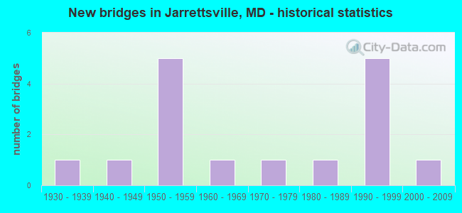
- New bridges - historical statistics
- 11930-1939
- 11940-1949
- 51950-1959
- 11960-1969
- 11970-1979
- 11980-1989
- 51990-1999
- 12000-2009

- Reconstructed bridges - Historical Statistics
- 11960-1969
- 21970-1979
- 01980-1989
- 11990-1999
- 12000-2009


- Bridge Condition - Deck
- 7.1%Very good
- 28.6%Good
- 35.7%Satisfactory
- 21.4%Fair
- 7.1%Poor

- Bridge Condition - Superstructure
- 14.3%Very good
- 35.7%Good
- 21.4%Satisfactory
- 21.4%Fair
- 7.1%Poor

- Bridge Condition - Substructure
- 50.0%Good
- 28.6%Satisfactory
- 21.4%Fair

- Bridge Condition - Channel
- 6.7%Very good
- 40.0%Good
- 46.7%Satisfactory
- 6.7%Fair
Find on map >> Show street view
Structure Number: 10000012004401, Location: 2.35 MILES SOUTH OF MD 24 (Lat: 39.662031, Lng: -76.448478), Route carried "on" structure: State highway 165, Year Built: 1930, Year Reconstructed: 1981, Status: Open, Structure Length: 1.22m (4.00ft), Average Daily Traffic: 6,035 (year 2013), Truck Traffic: 8%, Average Future Daily Traffic: 6,596 (year 2026), Features Intersected: LITTLE DEER CREEK
Minimum Vertical Clearance: 30+ m (98+ ft), Kilometerpoint: 18.310, Lanes on structure: 2, Base Highway Network: Yes, Owner: State Highway Agency, Approaching Roadway Width: 12.2m (40.0ft), Material/Design: Concrete, Design/Construction: Arch - Deck, Number Of Spans In Main Unit: 1, Length of Maximum Span: 12.2m (40.0ft), Curb-To-Curb Width: 7.3m (24.0ft), Out-to-Out Width: 8.3m (27.2ft)
Condition: Deck: Satisfactory, Superstructure: Satisfactory, Substructure: Good, Channel: Satisfactory, Operating Rating: 65.3 metric tons, Method Used To Determine Operating Rating: Load Factor (LF), Inventory Rating: 38.5 metric tons, Method Used To Determine Inventory Rating: Load Factor (LF), Structural Evaluation: Equal to present minimum criteria, Deck Geometry: High priority of replacement, Waterway Adequacy: Equal to present desirable criteria, Approach Roadway Alignment: Equal to present desirable criteria, Designated Inspection Frequency: Every 24 months, Underwater Inspection Frequency: Every 48 months, Inspection Date: December 2021, Underwater Inspection Date: April 2019, Deck Structure Type: Concrete Cast-file-Place, Wearing Surface/Protective System: Wearing Surface: Bituminous
Find on map >> Show street view
Structure Number: 10000017000601, Location: 0.59 MILE WEST OF MD 835 (Lat: 39.619067, Lng: -76.423278), Route carried "on" structure: State highway 18B, Year Built: 1951, Year Reconstructed: 1982, Status: Open, Structure Length: 20.21m (66.31ft), Average Daily Traffic: 5,057 (year 2018), Truck Traffic: 8%, Average Future Daily Traffic: 6,170 (year 2038), Design Load: HS 20, Features Intersected: KENT ISLAND NARROWS
Minimum Vertical Clearance: 30+ m (98+ ft), Kilometerpoint: 4.151, Lanes on structure: 2, Owner: State Highway Agency, Approaching Roadway Width: 17.7m (58.1ft), Skew: 20 degrees, Navigation Control: Yes ( Vertical Clearance: 5.5m (18.0ft), Horizontal Clearance: 15.2m (49.9ft)), Material/Design: Steel, Design/Construction: Movable - Bascule, Number Of Spans In Main Unit: 1, Number Of Approach Spans: 11, Length of Maximum Span: 22.6m (74.1ft), Curb or Sidewalk Widths: Left: 1.3m (4.3ft), Right: 1.3m (4.3ft), Curb-To-Curb Width: 17.7m (58.1ft), Out-to-Out Width: 20.9m (68.6ft)
Condition: Deck: Fair, Superstructure: Fair, Substructure: Fair, Channel: Fair, Operating Rating: 41.3 metric tons, Method Used To Determine Operating Rating: Load Factor (LF), Inventory Rating: 24.9 metric tons, Method Used To Determine Inventory Rating: Load Factor (LF), Structural Evaluation: Somewhat better than minimum adequacy, Deck Geometry: Superior to present desirable criteria, Waterway Adequacy: Superior to present desirable criteria, Approach Roadway Alignment: Equal to present desirable criteria, Length Of Structure Improvement: 20.21m (66.31ft), Designated Inspection Frequency: Every 12 months, Critical Feature Inspection Frequency: Every 12 months, Underwater Inspection Frequency: Every 48 months, Other Special Inspection Frequency: Every 12 months, Inspection Date: July 2021, Critical Feature Inspection Date: July 2021, Underwater Inspection Date: June 2020, Other Special Inspection Date: July 2021, Bridge Improvement Cost: $2,725,000, Roadway Improvement Cost: $272,000, Total Project Cost: $2,998,000, Deck Structure Type: Concrete Cast-file-Place
Find on map >> Show street view
Structure Number: 200000B-001101, Location: 0.6 MI E HESS ROAD (Lat: 39.572278, Lng: -76.540444), Route carried "on" structure: County highway 255, Year Built: 1978, Year Reconstructed: 2006, Status: Open, Structure Length: 1.62m (5.31ft), Average Daily Traffic: 221 (year 2020), Truck Traffic: 5%, Average Future Daily Traffic: 332 (year 2040), Design Load: H 15, Features Intersected: LITTLE GUNPOWDER FALLS, Facility Carried by Structure: POCOCK ROAD
Minimum Vertical Clearance: 30+ m (98+ ft), Kilometerpoint: 0.145, Lanes on structure: 1, Owner: County Highway Agency, Approaching Roadway Width: 4.9m (16.1ft), Skew: 2 degrees, Material/Design: Steel, Design/Construction: Girder and Floorbeam System, Number Of Spans In Main Unit: 1, Length of Maximum Span: 15.2m (49.9ft), Curb-To-Curb Width: 4.4m (14.4ft), Out-to-Out Width: 4.8m (15.7ft)
Condition: Deck: Satisfactory, Superstructure: Good, Substructure: Satisfactory, Channel: Good, Operating Rating: 72.1 metric tons, Method Used To Determine Operating Rating: Load Factor (LF), Inventory Rating: 43.1 metric tons, Method Used To Determine Inventory Rating: Load Factor (LF), Structural Evaluation: Equal to present minimum criteria, Deck Geometry: High priority of replacement, Waterway Adequacy: Better than present minimum criteria, Approach Roadway Alignment: Equal to present desirable criteria, Designated Inspection Frequency: Every 24 months, Critical Feature Inspection Frequency: Every 24 months, Inspection Date: May 2020, Critical Feature Inspection Date: May 2020, Deck Structure Type: Wood or Timber, Wearing Surface/Protective System: Wearing Surface: Wood or Timber
Find on map >> Show street view
Structure Number: 200000B-001301, Location: 0.8 MI E. of OLD YORK RD (Lat: 39.587700, Lng: -76.547203), Route carried "on" structure: County highway 253, Year Built: 1989, Status: Open, Structure Length: 1.55m (5.09ft), Average Daily Traffic: 643 (year 2020), Truck Traffic: 5%, Average Future Daily Traffic: 1,414 (year 2042), Design Load: HS 20, Features Intersected: LITTLE GUNPOWDER FALLS, Facility Carried by Structure: HOUCKS MILL ROAD
Minimum Vertical Clearance: 30+ m (98+ ft), Kilometerpoint: 0.000, Lanes on structure: 2, Owner: County Highway Agency, Approaching Roadway Width: 7.3m (24.0ft), Material/Design: Steel, Design/Construction: Truss - Thru, Number Of Spans In Main Unit: 1, Length of Maximum Span: 15.5m (50.9ft), Curb-To-Curb Width: 7.2m (23.6ft), Out-to-Out Width: 8.7m (28.5ft)
Condition: Deck: Satisfactory, Superstructure: Good, Substructure: Good, Channel: Satisfactory, Operating Rating: 44.0 metric tons, Method Used To Determine Operating Rating: Load Factor (LF), Inventory Rating: 26.3 metric tons, Method Used To Determine Inventory Rating: Load Factor (LF), Structural Evaluation: Equal to present minimum criteria, Deck Geometry: Meets minimum limits, Waterway Adequacy: Equal to present minimum criteria, Approach Roadway Alignment: Equal to present minimum criteria, Designated Inspection Frequency: Every 24 months, Critical Feature Inspection Frequency: Every 24 months, Inspection Date: January 2020, Critical Feature Inspection Date: January 2020, Deck Structure Type: Steel plate, Wearing Surface/Protective System: Wearing Surface: Other
Find on map >> Show street view
Structure Number: 200000H-007204, Location: 0.3 MILES NE OF MD 23 (Lat: 39.587019, Lng: -76.449989), Route carried "on" structure: County highway 66, Year Built: 1997, Status: Open, Structure Length: 1.16m (3.81ft), Average Daily Traffic: 1,005 (year 2019), Truck Traffic: 5%, Average Future Daily Traffic: 1,230 (year 2039), Design Load: HS 20, Features Intersected: EAST BRANCH/WINTERS RUN, Facility Carried by Structure: MORSE ROAD
Minimum Vertical Clearance: 30+ m (98+ ft), Kilometerpoint: 1.899, Lanes on structure: 2, Owner: County Highway Agency, Approaching Roadway Width: 7.3m (24.0ft), Material/Design: Concrete, Design/Construction: Frame, Number Of Spans In Main Unit: 1, Length of Maximum Span: 10.4m (34.1ft), Curb-To-Curb Width: 8.5m (27.9ft), Out-to-Out Width: 9.4m (30.8ft)
Condition: Deck: Satisfactory, Superstructure: Satisfactory, Substructure: Good, Channel: Good, Operating Rating: 77.5 metric tons, Method Used To Determine Operating Rating: Load Factor (LF), Inventory Rating: 46.7 metric tons, Method Used To Determine Inventory Rating: Load Factor (LF), Structural Evaluation: Equal to present minimum criteria, Deck Geometry: Somewhat better than minimum adequacy, Waterway Adequacy: Better than present minimum criteria, Approach Roadway Alignment: Equal to present desirable criteria, Designated Inspection Frequency: Every 24 months, Inspection Date: September 2021, Deck Structure Type: Concrete Cast-file-Place, Wearing Surface/Protective System: Wearing Surface: Monolithic Concrete, Deck Protection: Epoxy Coated Reinforcing
Find on map >> Show street view
Structure Number: 200000H-007401, Location: 0.6 MILES E OF MD 152 (Lat: 39.584197, Lng: -76.493178), Route carried "on" structure: County highway 43, Year Built: 1996, Status: Open, Structure Length: 1.37m (4.49ft), Average Daily Traffic: 1,550 (year 2019), Truck Traffic: 5%, Average Future Daily Traffic: 1,895 (year 2039), Design Load: HS 25 or greater, Features Intersected: WEST BRANCH/WINTERS RUN, Facility Carried by Structure: FURNACE ROAD
Minimum Vertical Clearance: 30+ m (98+ ft), Kilometerpoint: 0.901, Lanes on structure: 2, Owner: County Highway Agency, Approaching Roadway Width: 7.9m (25.9ft), Skew: 2 degrees, Material/Design: Prestressed concrete, Design/Construction: Stringer/Multi-beam, Number Of Spans In Main Unit: 1, Length of Maximum Span: 12.2m (40.0ft), Curb-To-Curb Width: 7.6m (24.9ft), Out-to-Out Width: 8.3m (27.2ft)
Condition: Deck: Good, Superstructure: Good, Substructure: Good, Channel: Good, Operating Rating: 97.2 metric tons, Method Used To Determine Operating Rating: Load and Resistance Factor Rating (LRFR) rating reported by rating factor(RF) method using HL-93 loadings, Inventory Rating: 44.7 metric tons, Method Used To Determine Inventory Rating: Load and Resistance Factor Rating (LRFR) rating reported by rating factor(RF) method using HL-93 loadings, Structural Evaluation: Better than present minimum criteria, Deck Geometry: Meets minimum limits, Waterway Adequacy: Better than present minimum criteria, Approach Roadway Alignment: Equal to present minimum criteria, Designated Inspection Frequency: Every 24 months, Inspection Date: August 2021, Deck Structure Type: Concrete Cast-file-Place, Wearing Surface/Protective System: Wearing Surface: Monolithic Concrete
Find on map >> Show street view
Structure Number: 200000H-008501, Location: 0.4 MILES N OF POCOCK RD (Lat: 39.582836, Lng: -76.532908), Route carried "on" structure: County highway 38, Year Built: 2003, Status: Open, Structure Length: 1.01m (3.31ft), Average Daily Traffic: 101 (year 2019), Truck Traffic: 5%, Average Future Daily Traffic: 174 (year 2039), Design Load: HS 25 or greater, Features Intersected: TRIB / L GUNPOWDER FALLS, Facility Carried by Structure: TURNER ROAD
Minimum Vertical Clearance: 30+ m (98+ ft), Kilometerpoint: 0.660, Lanes on structure: 2, Owner: County Highway Agency, Approaching Roadway Width: 6.1m (20.0ft), Skew: 2 degrees, Material/Design: Prestressed concrete, Design/Construction: Box Beam or Girders - Multiple, Number Of Spans In Main Unit: 1, Length of Maximum Span: 10.1m (33.1ft), Curb-To-Curb Width: 7.3m (24.0ft), Out-to-Out Width: 8.1m (26.6ft)
Condition: Deck: Good, Superstructure: Very good, Substructure: Good, Channel: Very good, Operating Rating: 84.4 metric tons, Method Used To Determine Operating Rating: Load Factor (LF), Inventory Rating: 50.3 metric tons, Method Used To Determine Inventory Rating: Load Factor (LF), Structural Evaluation: Better than present minimum criteria, Deck Geometry: Somewhat better than minimum adequacy, Waterway Adequacy: Equal to present minimum criteria, Approach Roadway Alignment: Equal to present minimum criteria, Designated Inspection Frequency: Every 24 months, Inspection Date: July 2021, Deck Structure Type: Concrete Cast-file-Place, Wearing Surface/Protective System: Wearing Surface: Monolithic Concrete, Deck Protection: Epoxy Coated Reinforcing
Find on map >> Show street view
Structure Number: 200000H-008701, Location: ON BALT CO LINE (Lat: 39.594839, Lng: -76.557439), Route carried "on" structure: County highway 40, Year Built: 1955, Status: Posted for load, Structure Length: 0.88m (2.89ft), Average Daily Traffic: 245 (year 2019), Truck Traffic: 5%, Average Future Daily Traffic: 300 (year 2039), Features Intersected: LITTLE GUNPOWDER FALLS, Facility Carried by Structure: OLD YORK ROAD
Minimum Vertical Clearance: 30+ m (98+ ft), Kilometerpoint: 3.041, Lanes on structure: 2, Owner: County Highway Agency, Approaching Roadway Width: 4.6m (15.1ft), Material/Design: Steel, Design/Construction: Stringer/Multi-beam, Number Of Spans In Main Unit: 1, Length of Maximum Span: 7.6m (24.9ft), Curb or Sidewalk Widths: Left: 0.2m (0.7ft), Right: 0.2m (0.7ft), Curb-To-Curb Width: 5.7m (18.7ft), Out-to-Out Width: 6.3m (20.7ft)
Condition: Deck: Satisfactory, Superstructure: Fair, Substructure: Fair, Channel: Satisfactory, Operating Rating: 42.6 metric tons, Method Used To Determine Operating Rating: Load Factor (LF), Inventory Rating: 25.4 metric tons, Method Used To Determine Inventory Rating: Load Factor (LF), Structural Evaluation: Somewhat better than minimum adequacy, Deck Geometry: High priority of corrective action, Waterway Adequacy: Equal to present minimum criteria, Approach Roadway Alignment: Better than present minimum criteria, Bridge Posting: Required (Relationship of Operating Rating to Maximum Legal Load: 10.0 - 19.9% below), Length Of Structure Improvement: 0.91m (2.99ft), Designated Inspection Frequency: Every 24 months, Other Special Inspection Frequency: Every 12 months, Inspection Date: September 2021, Other Special Inspection Date: September 2021, Bridge Improvement Cost: $135,000, Roadway Improvement Cost: $14,000, Total Project Cost: $149,000, Deck Structure Type: Concrete Cast-file-Place, Wearing Surface/Protective System: Wearing Surface: Monolithic Concrete
Find on map >> Show street view
Structure Number: 200000H-009001, Location: 0.2 MILES E OF MD 146 (Lat: 39.595919, Lng: -76.507917), Route carried "on" structure: County highway 34, Year Built: 1999, Status: Open, Structure Length: 1.22m (4.00ft), Average Daily Traffic: 4,200 (year 2019), Truck Traffic: 5%, Average Future Daily Traffic: 5,125 (year 2039), Design Load: HS 20, Features Intersected: WEST BRANCH/ WINTERS RUN, Facility Carried by Structure: SCHUSTER ROAD
Minimum Vertical Clearance: 30+ m (98+ ft), Kilometerpoint: 0.386, Lanes on structure: 2, Owner: County Highway Agency, Approaching Roadway Width: 8.5m (27.9ft), Skew: 2 degrees, Material/Design: Steel, Design/Construction: Stringer/Multi-beam, Number Of Spans In Main Unit: 1, Length of Maximum Span: 11.0m (36.1ft), Curb-To-Curb Width: 8.5m (27.9ft), Out-to-Out Width: 9.3m (30.5ft)
Condition: Deck: Very good, Superstructure: Very good, Substructure: Good, Channel: Satisfactory, Inventory Rating: 64.9 metric tons, Method Used To Determine Inventory Rating: Load Factor (LF), Structural Evaluation: Better than present minimum criteria, Deck Geometry: Meets minimum limits, Waterway Adequacy: Equal to present minimum criteria, Approach Roadway Alignment: Equal to present desirable criteria, Designated Inspection Frequency: Every 24 months, Inspection Date: October 2021, Deck Structure Type: Concrete Cast-file-Place, Wearing Surface/Protective System: Wearing Surface: Monolithic Concrete
Find on map >> Show street view
Structure Number: 200000H-010001, Location: 1.0 MILES S OF MD 165 (Lat: 39.652094, Lng: -76.438117), Route carried "on" structure: County highway 82, Year Built: 1954, Status: Posted for load, Structure Length: 5.88m (19.29ft), Average Daily Traffic: 563 (year 2019), Truck Traffic: 5%, Average Future Daily Traffic: 687 (year 2039), Design Load: H 20, Features Intersected: DEER CREEK, Facility Carried by Structure: ST CLAIR BRIDGE RD
Minimum Vertical Clearance: 30+ m (98+ ft), Kilometerpoint: 1.561, Lanes on structure: 2, Owner: County Highway Agency, Approaching Roadway Width: 6.1m (20.0ft), Skew: 4 degrees, Material/Design: Steel, Design/Construction: Stringer/Multi-beam, Number Of Spans In Main Unit: 3, Length of Maximum Span: 27.4m (89.9ft), Curb or Sidewalk Widths: Left: 0.6m (2.0ft), Right: 0.6m (2.0ft), Curb-To-Curb Width: 6.8m (22.3ft), Out-to-Out Width: 8.0m (26.2ft)
Condition: Deck: Fair, Superstructure: Satisfactory, Substructure: Fair, Channel: Satisfactory, Operating Rating: 69.8 metric tons, Method Used To Determine Operating Rating: Load Factor (LF), Inventory Rating: 41.7 metric tons, Method Used To Determine Inventory Rating: Load Factor (LF), Structural Evaluation: Somewhat better than minimum adequacy, Deck Geometry: Meets minimum limits, Waterway Adequacy: Equal to present desirable criteria, Approach Roadway Alignment: Equal to present desirable criteria, Designated Inspection Frequency: Every 24 months, Inspection Date: September 2021, Deck Structure Type: Concrete Cast-file-Place, Wearing Surface/Protective System: Wearing Surface: Monolithic Concrete
Find on map >> Show street view
Structure Number: 200000H-010301, Location: 1.5 MILES NE OF MD 23 (Lat: 39.634178, Lng: -76.527150), Route carried "on" structure: County highway 20, Year Built: 1940, Year Reconstructed: 1960, Status: Posted for load, Structure Length: 0.82m (2.69ft), Average Daily Traffic: 335 (year 2019), Truck Traffic: 5%, Average Future Daily Traffic: 410 (year 2039), Features Intersected: TRIB / LITTLE DEER CREEK, Facility Carried by Structure: TROYER ROAD
Minimum Vertical Clearance: 30+ m (98+ ft), Kilometerpoint: 2.381, Lanes on structure: 2, Owner: County Highway Agency, Approaching Roadway Width: 5.5m (18.0ft), Skew: 2 degrees, Material/Design: Steel, Design/Construction: Stringer/Multi-beam, Number Of Spans In Main Unit: 1, Length of Maximum Span: 7.6m (24.9ft), Curb or Sidewalk Widths: Left: 0.3m (1.0ft), Right: 0.3m (1.0ft), Curb-To-Curb Width: 6.1m (20.0ft), Out-to-Out Width: 6.7m (22.0ft)
Condition: Deck: Poor, Superstructure: Poor, Substructure: Satisfactory, Channel: Good, Operating Rating: 33.6 metric tons, Method Used To Determine Operating Rating: Load Factor (LF), Inventory Rating: 20.0 metric tons, Method Used To Determine Inventory Rating: Load Factor (LF), Structural Evaluation: Meets minimum limits, Deck Geometry: Meets minimum limits, Waterway Adequacy: Better than present minimum criteria, Approach Roadway Alignment: Somewhat better than minimum adequacy, Bridge Posting: Required (Relationship of Operating Rating to Maximum Legal Load: 0.1 - 9.9% below), Length Of Structure Improvement: 0.98m (3.22ft), Designated Inspection Frequency: Every 24 months, Other Special Inspection Frequency: Every 12 months, Inspection Date: September 2021, Other Special Inspection Date: September 2021, Bridge Improvement Cost: $154,000, Roadway Improvement Cost: $15,000, Total Project Cost: $169,000, Deck Structure Type: Corrugated Steel, Wearing Surface/Protective System: Wearing Surface: Bituminous
Find on map >> Show street view
Structure Number: 200000H-010502, Location: 0.4 MILE S OF MT HOREB RD (Lat: 39.653439, Lng: -76.492528), Route carried "on" structure: County highway 22, Year Built: 1992, Status: Open, Structure Length: 1.31m (4.30ft), Average Daily Traffic: 758 (year 2019), Truck Traffic: 5%, Average Future Daily Traffic: 909 (year 2039), Design Load: HS 20, Features Intersected: CATTAIL BRANCH, Facility Carried by Structure: MADONNA ROAD
Minimum Vertical Clearance: 30+ m (98+ ft), Kilometerpoint: 5.020, Lanes on structure: 2, Owner: County Highway Agency, Approaching Roadway Width: 10.4m (34.1ft), Skew: 3 degrees, Material/Design: Concrete, Design/Construction: Culvert, Length of Maximum Span: 5.5m (18.0ft)
Condition: Channel: Good, Culverts: Good, Inventory Rating: 60.3 metric tons, Method Used To Determine Inventory Rating: Load Factor (LF), Structural Evaluation: Better than present minimum criteria, Waterway Adequacy: Superior to present desirable criteria, Approach Roadway Alignment: Better than present minimum criteria, Designated Inspection Frequency: Every 24 months, Inspection Date: July 2021
Find on map >> Show street view
Structure Number: 200000H-010601, Location: 0.3 MILE S OF MT HOREB RD (Lat: 39.654192, Lng: -76.490567), Route carried "on" structure: County highway 22, Year Built: 1992, Status: Open, Structure Length: 1.98m (6.50ft), Average Daily Traffic: 758 (year 2019), Truck Traffic: 5%, Average Future Daily Traffic: 909 (year 2039), Design Load: HS 20, Features Intersected: LITTLE DEER CREEK, Facility Carried by Structure: MADONNA ROAD
Minimum Vertical Clearance: 30+ m (98+ ft), Kilometerpoint: 5.229, Lanes on structure: 2, Owner: County Highway Agency, Approaching Roadway Width: 10.4m (34.1ft), Material/Design: Steel, Design/Construction: Stringer/Multi-beam, Number Of Spans In Main Unit: 1, Length of Maximum Span: 18.3m (60.0ft), Curb-To-Curb Width: 10.4m (34.1ft), Out-to-Out Width: 11.3m (37.1ft)
Condition: Deck: Good, Superstructure: Good, Substructure: Satisfactory, Channel: Satisfactory, Inventory Rating: 63.9 metric tons, Method Used To Determine Inventory Rating: Load Factor (LF), Structural Evaluation: Equal to present minimum criteria, Deck Geometry: Equal to present minimum criteria, Waterway Adequacy: Superior to present desirable criteria, Approach Roadway Alignment: Better than present minimum criteria, Designated Inspection Frequency: Every 24 months, Inspection Date: July 2021, Deck Structure Type: Concrete Cast-file-Place, Wearing Surface/Protective System: Wearing Surface: Monolithic Concrete, Deck Protection: Epoxy Coated Reinforcing
Find on map >> Show street view
Structure Number: 200000H-010701, Location: 1.2 MILES NW OF MD 165 (Lat: 39.658097, Lng: -76.483489), Route carried "on" structure: County highway 25, Year Built: 1955, Year Reconstructed: 1998, Status: Open, Structure Length: 1.71m (5.61ft), Average Daily Traffic: 751 (year 2019), Truck Traffic: 5%, Average Future Daily Traffic: 866 (year 2039), Design Load: HS 20, Features Intersected: LITTLE DEER CREEK, Facility Carried by Structure: MT HOREB ROAD
Minimum Vertical Clearance: 30+ m (98+ ft), Kilometerpoint: 1.883, Lanes on structure: 2, Owner: County Highway Agency, Approaching Roadway Width: 5.8m (19.0ft), Skew: 2 degrees, Material/Design: Steel, Design/Construction: Stringer/Multi-beam, Number Of Spans In Main Unit: 1, Length of Maximum Span: 16.2m (53.1ft), Curb-To-Curb Width: 4.9m (16.1ft), Out-to-Out Width: 5.6m (18.4ft)
Condition: Deck: Good, Superstructure: Good, Substructure: Good, Channel: Good, Inventory Rating: 85.7 metric tons, Method Used To Determine Inventory Rating: Load Factor (LF), Structural Evaluation: Better than present minimum criteria, Deck Geometry: High priority of replacement, Waterway Adequacy: Superior to present desirable criteria, Approach Roadway Alignment: Equal to present minimum criteria, Designated Inspection Frequency: Every 24 months, Inspection Date: September 2021, Deck Structure Type: Concrete Cast-file-Place, Wearing Surface/Protective System: Wearing Surface: Monolithic Concrete, Deck Protection: Epoxy Coated Reinforcing
Find on map >> Show street view
Structure Number: 200000H-017501, Location: 1.9 MILES E OF MD 165 (Lat: 39.606003, Lng: -76.445697), Route carried "on" structure: County highway 617, Year Built: 1950, Status: Open, Structure Length: 0.85m (2.79ft), Average Daily Traffic: 4,308 (year 2019), Truck Traffic: 5%, Average Future Daily Traffic: 5,257 (year 2039), Features Intersected: EAST BRANCH /WINTERS RUN, Facility Carried by Structure: JARRETTSVILLE ROAD
Minimum Vertical Clearance: 30+ m (98+ ft), Kilometerpoint: 10.314, Lanes on structure: 2, Owner: County Highway Agency, Approaching Roadway Width: 7.0m (23.0ft), Material/Design: Concrete, Design/Construction: Slab, Number Of Spans In Main Unit: 2, Length of Maximum Span: 4.0m (13.1ft), Curb or Sidewalk Widths: Left: 0.2m (0.7ft), Right: 0.2m (0.7ft), Curb-To-Curb Width: 6.8m (22.3ft), Out-to-Out Width: 7.3m (24.0ft)
Condition: Deck: Fair, Superstructure: Fair, Substructure: Satisfactory, Channel: Satisfactory, Operating Rating: 32.7 metric tons, Method Used To Determine Operating Rating: Field evaluation and documented engineering judgment, Inventory Rating: 32.7 metric tons, Method Used To Determine Inventory Rating: Field evaluation and documented engineering judgment, Structural Evaluation: Somewhat better than minimum adequacy, Deck Geometry: High priority of replacement, Waterway Adequacy: Somewhat better than minimum adequacy, Approach Roadway Alignment: Equal to present desirable criteria, Length Of Structure Improvement: 0.85m (2.79ft), Designated Inspection Frequency: Every 24 months, Inspection Date: August 2021, Bridge Improvement Cost: $80,000, Roadway Improvement Cost: $8,000, Total Project Cost: $88,000, Deck Structure Type: Concrete Cast-file-Place, Wearing Surface/Protective System: Wearing Surface: Bituminous
Find on map >> Show street view
Structure Number: 10000012006401, Location: 1.03 MILES S OF MD 165 (Lat: 39.583483, Lng: -76.454092), Route carried "under" structure: County highway 66, Year Built: 1961, Structure Length: 0. m, Features Intersected: MORSE ROAD, Facility Carried by Structure: MD 23
Minimum Vertical Clearance: 4.57m (14.99ft), Kilometerpoint: 1.345, Lanes on structure: 2, Lanes under structure: 2, Material/Design: Steel, Design/Construction: Stringer/Multi-beam, Length of Maximum Span: 13.1m (43.0ft)