Bridge Statistics for Jamestown, Rhode Island (RI)
Condition, Traffic, Stress, Structural Evaluation, Project Costs
- National Bridge Inventory (NBI) Statistics
- 12Number of bridges
- 1,906ft / 581mTotal length
- $363,123,000Total costs
- 235,700Total average daily traffic
- 15,768Total average daily truck traffic
- National Bridge Inventory (NBI) Registered Bridges for Jamestown
- No street view available for this location
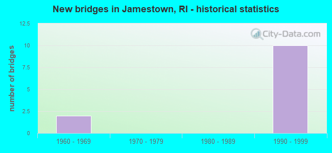
- New bridges - historical statistics
- 21960-1969
- 101990-1999


- Bridge Condition - Deck
- 40.0%Good
- 20.0%Satisfactory
- 40.0%Fair

- Bridge Condition - Superstructure
- 55.6%Good
- 11.1%Satisfactory
- 33.3%Fair

- Bridge Condition - Substructure
- 66.7%Good
- 33.3%Satisfactory

- Bridge Condition - Channel
- 25.0%Very good
- 75.0%Good
Find on map >> Show street view
Structure Number: 8, Location: 2.0 Mi E of JCT US 1 (Lat: 41.528328, Lng: -71.402758), Route carried "on" structure: State highway 138, Year Built: 1992, Year Reconstructed: 2009, Status: Open, Structure Length: 224.12m (735.30ft), Average Daily Traffic: 33,100 (year 2021), Truck Traffic: 4%, Average Future Daily Traffic: 36,410 (year 2041), Design Load: HS 20, Features Intersected: WEST PASSAGE NARRA BAY
Minimum Vertical Clearance: 30+ m (98+ ft), Kilometerpoint: 44.485, Lanes on structure: 4, Lanes under structure: 2, Base Highway Network: Yes, Owner: State Toll Authority, Approaching Roadway Width: 19.5m (64.0ft), Skew: 30 degrees, Navigation Control: Yes ( Vertical Clearance: 41.1m (134.8ft), Horizontal Clearance: 182.9m (600.1ft)), Material/Design: Prestressed concrete continuous, Design/Construction: Segmental Box Girder, Number Of Spans In Main Unit: 23, Number Of Approach Spans: 29, Length of Maximum Span: 193.9m (636.2ft), Curb or Sidewalk Widths: Left: 1.0m (3.3ft), Right: 1.0m (3.3ft), Curb-To-Curb Width: 19.5m (64.0ft), Out-to-Out Width: 22.6m (74.1ft)
Condition: Deck: Satisfactory, Superstructure: Satisfactory, Substructure: Satisfactory, Channel: Good, Operating Rating: 68.0 metric tons, Method Used To Determine Operating Rating: Load and Resistance Factor (LRFR), Inventory Rating: 52.6 metric tons, Method Used To Determine Inventory Rating: Load and Resistance Factor (LRFR), Structural Evaluation: Equal to present minimum criteria, Deck Geometry: Somewhat better than minimum adequacy, Underclear: Superior to present desirable criteria, Waterway Adequacy: Better than present minimum criteria, Approach Roadway Alignment: Better than present minimum criteria, Length Of Structure Improvement: 224.12m (735.30ft), Designated Inspection Frequency: Every 24 months, Underwater Inspection Frequency: Every 60 months, Inspection Date: May 2021, Underwater Inspection Date: July 2021, Bridge Improvement Cost: $122,671,000, Roadway Improvement Cost: $1,227,000, Total Project Cost: $184,006,000, Deck Structure Type: Concrete Cast-file-Place, Wearing Surface/Protective System: Wearing Surface: Latex Concrete, Deck Protection: Epoxy Coated Reinforcing
Find on map >> Show street view
Structure Number: 88, Location: 0.1 Mi NW of Nwprt Brdge (Lat: 41.508603, Lng: -71.364250), Route carried "on" structure: State highway 138, Year Built: 1969, Status: Open, Structure Length: 2.62m (8.60ft), Average Daily Traffic: 4,100 (year 2021), Truck Traffic: 7%, Average Future Daily Traffic: 4,510 (year 2041), Design Load: HS 20, Features Intersected: EAST SHORE RD
Minimum Vertical Clearance: 30+ m (98+ ft), Kilometerpoint: 49.476, Lanes on structure: 4, Lanes under structure: 2, Base Highway Network: Yes, Toll: Toll bridge, Owner: State Toll Authority, Approaching Roadway Width: 14.6m (47.9ft), Skew: 30 degrees, Material/Design: Steel, Design/Construction: Stringer/Multi-beam, Number Of Spans In Main Unit: 1, Length of Maximum Span: 24.4m (80.1ft), Curb or Sidewalk Widths: Left: 0.9m (3.0ft), Right: 0.9m (3.0ft), Curb-To-Curb Width: 14.6m (47.9ft), Out-to-Out Width: 18.9m (62.0ft)
Condition: Deck: Fair, Superstructure: Good, Substructure: Satisfactory, Operating Rating: 51.5 metric tons, Method Used To Determine Operating Rating: Load and Resistance Factor (LRFR), Inventory Rating: 39.9 metric tons, Method Used To Determine Inventory Rating: Load and Resistance Factor (LRFR), Structural Evaluation: Equal to present minimum criteria, Deck Geometry: High priority of replacement, Underclear: Meets minimum limits, Approach Roadway Alignment: Equal to present desirable criteria, Length Of Structure Improvement: 2.62m (8.60ft), Designated Inspection Frequency: Every 24 months, Inspection Date: September 2021, Bridge Improvement Cost: $1,690,000, Roadway Improvement Cost: $169,000, Total Project Cost: $2,535,000, Deck Structure Type: Concrete Cast-file-Place, Wearing Surface/Protective System: Wearing Surface: Bituminous, Membrane: Epoxy
Find on map >> Show street view
Structure Number: 9, Location: Betwn Jamestown NEWPORT (Lat: 41.503675, Lng: -71.342892), Route carried "on" structure: State highway 138, Year Built: 1969, Status: Posted for load-capacity, Structure Length: 342.84m (1124.80ft), Average Daily Traffic: 28,000 (year 2016), Truck Traffic: 2%, Average Future Daily Traffic: 24,012 (year 2036), Design Load: HS 20, Features Intersected: EAST PASSAGE NARR BAY
Minimum Vertical Clearance: 4.97m (16.31ft), Kilometerpoint: 51.356, Lanes on structure: 4, Lanes under structure: 2, Base Highway Network: Yes, Toll: Toll bridge, Owner: State Toll Authority, Approaching Roadway Width: 14.6m (47.9ft), Skew: 30 degrees, Navigation Control: Yes ( Vertical Clearance: 30.5m (100.1ft), Horizontal Clearance: 30.5m (100.1ft)), Material/Design: Steel, Design/Construction: Suspension, Number Of Spans In Main Unit: 3, Number Of Approach Spans: 52, Length of Maximum Span: 487.7m (1,600.1ft), Curb or Sidewalk Widths: Left: 0.9m (3.0ft), Right: 0.9m (3.0ft), Curb-To-Curb Width: 14.2m (46.6ft), Out-to-Out Width: 16.5m (54.1ft)
Condition: Deck: Fair, Superstructure: Fair, Substructure: Satisfactory, Channel: Good, Operating Rating: 33.7 metric tons, Method Used To Determine Operating Rating: Load and Resistance Factor Rating (LRFR) rating reported by rating factor(RF) method using HL-93 loadings, Inventory Rating: 23.3 metric tons, Method Used To Determine Inventory Rating: Load and Resistance Factor Rating (LRFR) rating reported by rating factor(RF) method using HL-93 loadings, Structural Evaluation: Somewhat better than minimum adequacy, Deck Geometry: High priority of replacement, Waterway Adequacy: Equal to present desirable criteria, Approach Roadway Alignment: Equal to present desirable criteria, Length Of Structure Improvement: 342.84m (1124.80ft), Designated Inspection Frequency: Every 24 months, Critical Feature Inspection Frequency: Every 24 months, Underwater Inspection Frequency: Every 60 months, Inspection Date: November 2020, Critical Feature Inspection Date: November 2020, Underwater Inspection Date: May 2017, Bridge Improvement Cost: $117,721,000, Roadway Improvement Cost: $11,772,000, Total Project Cost: $176,582,000, Deck Structure Type: Concrete Cast-file-Place, Wearing Surface/Protective System: Wearing Surface: Integral Concrete
Find on map >> Show street view
Structure Number: 902, Location: 3.8 Mi E of Jct US 1 (Lat: 41.526125, Lng: -71.374869), Route carried "on" structure: State highway 138, Year Built: 1994, Status: Open, Structure Length: 3.83m (12.57ft), Average Daily Traffic: 13,800 (year 2015), Truck Traffic: 1%, Average Future Daily Traffic: 16,560 (year 2036), Design Load: HS 25 or greater, Features Intersected: N MAIN RD & JAMESTOWN BK
Minimum Vertical Clearance: 30+ m (98+ ft), Kilometerpoint: 47.223, Lanes on structure: 2, Lanes under structure: 3, Base Highway Network: Yes, Owner: State Toll Authority, Approaching Roadway Width: 11.4m (37.4ft), Material/Design: Prestressed concrete, Design/Construction: Stringer/Multi-beam, Number Of Spans In Main Unit: 1, Length of Maximum Span: 36.6m (120.1ft), Curb-To-Curb Width: 11.4m (37.4ft), Out-to-Out Width: 12.6m (41.3ft)
Condition: Deck: Good, Superstructure: Fair, Substructure: Good, Channel: Good, Operating Rating: 66.7 metric tons, Method Used To Determine Operating Rating: Load and Resistance Factor Rating (LRFR) rating reported by rating factor(RF) method using HL-93 loadings, Inventory Rating: 49.9 metric tons, Method Used To Determine Inventory Rating: Load and Resistance Factor Rating (LRFR) rating reported by rating factor(RF) method using HL-93 loadings, Structural Evaluation: Somewhat better than minimum adequacy, Deck Geometry: Somewhat better than minimum adequacy, Underclear: High priority of corrective action, Approach Roadway Alignment: Better than present minimum criteria, Designated Inspection Frequency: Every 24 months, Inspection Date: May 2020, Deck Structure Type: Concrete Cast-file-Place, Wearing Surface/Protective System: Wearing Surface: Bituminous, Membrane: Built-up, Deck Protection: Epoxy Coated Reinforcing
Find on map >> Show street view
Structure Number: 9022, Location: 3.8 Mi E of Jct US 1 (Lat: 41.526292, Lng: -71.374867), Route carried "on" structure: State highway 138, Year Built: 1994, Status: Open, Structure Length: 3.83m (12.57ft), Average Daily Traffic: 13,800 (year 2006), Truck Traffic: 10%, Average Future Daily Traffic: 16,560 (year 2036), Design Load: HS 25 or greater, Features Intersected: N MAIN RD & JAMESTOWN BK
Minimum Vertical Clearance: 30+ m (98+ ft), Kilometerpoint: 2.609, Lanes on structure: 2, Lanes under structure: 3, Base Highway Network: Yes, Owner: State Toll Authority, Approaching Roadway Width: 11.4m (37.4ft), Material/Design: Prestressed concrete, Design/Construction: Stringer/Multi-beam, Number Of Spans In Main Unit: 1, Length of Maximum Span: 36.6m (120.1ft), Curb-To-Curb Width: 11.4m (37.4ft), Out-to-Out Width: 12.6m (41.3ft)
Condition: Deck: Good, Superstructure: Fair, Substructure: Good, Channel: Very good, Operating Rating: 66.4 metric tons, Method Used To Determine Operating Rating: Load and Resistance Factor Rating (LRFR) rating reported by rating factor(RF) method using HL-93 loadings, Inventory Rating: 49.6 metric tons, Method Used To Determine Inventory Rating: Load and Resistance Factor Rating (LRFR) rating reported by rating factor(RF) method using HL-93 loadings, Structural Evaluation: Somewhat better than minimum adequacy, Deck Geometry: Somewhat better than minimum adequacy, Underclear: High priority of corrective action, Approach Roadway Alignment: Equal to present desirable criteria, Designated Inspection Frequency: Every 24 months, Inspection Date: May 2020, Deck Structure Type: Concrete Cast-file-Place, Wearing Surface/Protective System: Wearing Surface: Bituminous, Membrane: Built-up, Deck Protection: Epoxy Coated Reinforcing
Find on map >> Show street view
Structure Number: 909, Location: 3.8 mi E Jct US 1A/RI138 (Lat: 41.526233, Lng: -71.374269), Route carried "on" structure: State highway 138, Year Built: 1994, Status: Open, Structure Length: 0.91m (2.99ft), Average Daily Traffic: 26,700 (year 2006), Truck Traffic: 10%, Average Future Daily Traffic: 32,040 (year 2036), Design Load: HS 25 or greater, Features Intersected: Wildlife Passage
Minimum Vertical Clearance: 30+ m (98+ ft), Kilometerpoint: 2.557, Lanes on structure: 4, Base Highway Network: Yes, Owner: State Toll Authority, Approaching Roadway Width: 23.2m (76.1ft), Skew: 30 degrees, Material/Design: Concrete, Design/Construction: Arch - Deck, Number Of Spans In Main Unit: 1, Length of Maximum Span: 9.1m (29.9ft), Curb or Sidewalk Widths: Left: 0.1m (0.3ft), Right: 0.1m (0.3ft), Curb-To-Curb Width: 23.2m (76.1ft), Out-to-Out Width: 31.0m (101.7ft)
Condition: Superstructure: Good, Substructure: Good, Structural Evaluation: Better than present minimum criteria, Deck Geometry: Superior to present desirable criteria, Approach Roadway Alignment: Equal to present desirable criteria, Designated Inspection Frequency: Every 24 months, Inspection Date: May 2020
Find on map >> Show street view
Structure Number: 91, Location: 3.8 Mi.E Jct Us1A/RI138 (Lat: 41.526267, Lng: -71.373553), Route carried "on" structure: State highway 138, Year Built: 1994, Status: Open, Structure Length: 0.91m (2.99ft), Average Daily Traffic: 26,700 (year 2006), Truck Traffic: 10%, Average Future Daily Traffic: 32,040 (year 2036), Design Load: HS 25 or greater, Features Intersected: Wildlife Passage
Minimum Vertical Clearance: 30+ m (98+ ft), Kilometerpoint: 2.498, Lanes on structure: 4, Base Highway Network: Yes, Owner: State Toll Authority, Approaching Roadway Width: 23.2m (76.1ft), Skew: 30 degrees, Material/Design: Concrete, Design/Construction: Arch - Deck, Number Of Spans In Main Unit: 1, Length of Maximum Span: 9.1m (29.9ft), Curb or Sidewalk Widths: Left: 0.1m (0.3ft), Right: 0.1m (0.3ft), Curb-To-Curb Width: 23.2m (76.1ft), Out-to-Out Width: 31.2m (102.4ft)
Condition: Superstructure: Good, Substructure: Good, Structural Evaluation: Better than present minimum criteria, Deck Geometry: Superior to present desirable criteria, Approach Roadway Alignment: Equal to present desirable criteria, Designated Inspection Frequency: Every 24 months, Inspection Date: May 2020
Find on map >> Show street view
Structure Number: 911, Location: 3.8 Mi E Jct US1A/RI138 (Lat: 41.526272, Lng: -71.372697), Route carried "on" structure: State highway 138, Year Built: 1994, Status: Open, Structure Length: 0.91m (2.99ft), Average Daily Traffic: 26,700 (year 2006), Truck Traffic: 10%, Average Future Daily Traffic: 32,040 (year 2036), Design Load: HS 25 or greater, Features Intersected: Wildlife Passage
Minimum Vertical Clearance: 30+ m (98+ ft), Kilometerpoint: 2.427, Lanes on structure: 5, Base Highway Network: Yes, Owner: State Toll Authority, Approaching Roadway Width: 25.2m (82.7ft), Skew: 30 degrees, Material/Design: Concrete, Design/Construction: Arch - Deck, Number Of Spans In Main Unit: 1, Length of Maximum Span: 9.1m (29.9ft), Curb or Sidewalk Widths: Left: 0.1m (0.3ft), Right: 0.1m (0.3ft), Curb-To-Curb Width: 25.2m (82.7ft), Out-to-Out Width: 33.4m (109.6ft)
Condition: Superstructure: Good, Substructure: Good, Structural Evaluation: Better than present minimum criteria, Deck Geometry: Better than present minimum criteria, Approach Roadway Alignment: Equal to present desirable criteria, Designated Inspection Frequency: Every 24 months, Inspection Date: May 2020
Find on map >> Show street view
Structure Number: 912, Location: 3.8 Mi E Jct US1A/RI138 (Lat: 41.526219, Lng: -71.372036), Route carried "on" structure: State highway 138, Year Built: 1994, Status: Open, Structure Length: 0.91m (2.99ft), Average Daily Traffic: 26,700 (year 2006), Truck Traffic: 10%, Average Future Daily Traffic: 32,040 (year 2036), Design Load: HS 25 or greater, Features Intersected: Wildlife Passage
Minimum Vertical Clearance: 30+ m (98+ ft), Kilometerpoint: 2.369, Lanes on structure: 5, Base Highway Network: Yes, Owner: State Toll Authority, Approaching Roadway Width: 26.7m (87.6ft), Skew: 30 degrees, Material/Design: Concrete, Design/Construction: Arch - Deck, Number Of Spans In Main Unit: 1, Length of Maximum Span: 9.1m (29.9ft), Curb or Sidewalk Widths: Left: 0.1m (0.3ft), Right: 0.1m (0.3ft), Curb-To-Curb Width: 26.7m (87.6ft), Out-to-Out Width: 34.9m (114.5ft)
Condition: Superstructure: Good, Substructure: Good, Structural Evaluation: Better than present minimum criteria, Deck Geometry: Superior to present desirable criteria, Approach Roadway Alignment: Equal to present desirable criteria, Designated Inspection Frequency: Every 24 months, Inspection Date: May 2020
Find on map >> Show street view
Structure Number: 8, Location: 2.0 Mi E of JCT US 1 (Lat: 41.528328, Lng: -71.402758), Route carried "under" structure: City street , Year Built: 1992, Structure Length: 0. m, Average Daily Traffic: 33,100 (year 2021), Truck Traffic: 4%, Features Intersected: WEST PASSAGE NARRA BAY, Facility Carried by Structure: RI 138
Minimum Vertical Clearance: 10.10m (33.14ft), Kilometerpoint: 0.000, Lanes on structure: 4, Lanes under structure: 2, Material/Design: Prestressed concrete continuous, Design/Construction: Segmental Box Girder, Length of Maximum Span: 193.9m (636.2ft)
Find on map >> Show street view
Structure Number: 902, Location: 3.8 Mi E of Jct US 1 (Lat: 41.526125, Lng: -71.374869), Route carried "under" structure: City street , Year Built: 1994, Structure Length: 0. m, Average Daily Traffic: 1,500 (year 2008), Truck Traffic: 2%, Features Intersected: N MAIN RD & JAMESTOWN BK, Facility Carried by Structure: RI 138 EASTBOUND
Minimum Vertical Clearance: 4.37m (14.34ft), Kilometerpoint: 0.000, Lanes on structure: 2, Lanes under structure: 3, Material/Design: Prestressed concrete, Design/Construction: Stringer/Multi-beam, Length of Maximum Span: 36.6m (120.1ft)
Find on map >> Show street view
Structure Number: 9022, Location: 3.8 Mi E of Jct US 1 (Lat: 41.526292, Lng: -71.374867), Route carried "under" structure: City street , Year Built: 1994, Structure Length: 0. m, Average Daily Traffic: 1,500 (year 2008), Truck Traffic: 3%, Features Intersected: N MAIN RD & JAMESTOWN BK, Facility Carried by Structure: RI 138 WB
Minimum Vertical Clearance: 4.37m (14.34ft), Kilometerpoint: 0.000, Lanes on structure: 2, Lanes under structure: 3, Material/Design: Prestressed concrete, Design/Construction: Stringer/Multi-beam, Length of Maximum Span: 36.6m (120.1ft)