Bridge Statistics for Jacob City, Florida (FL)
Condition, Traffic, Stress, Structural Evaluation, Project Costs
- National Bridge Inventory (NBI) Statistics
- 11Number of bridges
- 364ft / 111mTotal length
- 163,043Total average daily traffic
- 8,420Total average daily truck traffic
- National Bridge Inventory (NBI) Registered Bridges for Jacob City
- No street view available for this location
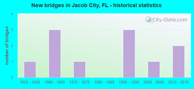
- New bridges - historical statistics
- 11950-1959
- 31960-1969
- 11970-1979
- 31990-1999
- 12000-2009
- 22010-2019


- Bridge Condition - Deck
- 33.3%Good
- 50.0%Satisfactory
- 16.7%Fair

- Bridge Condition - Superstructure
- 50.0%Good
- 33.3%Satisfactory
- 16.7%Poor

- Bridge Condition - Substructure
- 33.3%Satisfactory
- 33.3%Fair
- 33.3%Poor

- Bridge Condition - Channel
- 25.0%Good
- 37.5%Satisfactory
- 37.5%Fair

- Bridge Condition - Culverts
- 50.0%Good
- 50.0%Satisfactory
Find on map >> Show street view
Structure Number: 25002, Location: 0.06MI N OF SE 10TH ST (Lat: 28.887892, Lng: -82.591442), Route carried "on" structure: City street , Year Built: 1960, Status: Posted for load-capacity, Structure Length: 0.79m (2.59ft), Average Daily Traffic: 100 (year 2022), Truck Traffic: 2%, Average Future Daily Traffic: 200 (year 2042), Features Intersected: SPRING RUN CANAL, Facility Carried by Structure: SE 1ST COURT
Minimum Vertical Clearance: 30+ m (98+ ft), Kilometerpoint: 0.000, Lanes on structure: 2, Owner: City or Municipal Highway Agency, Approaching Roadway Width: 5.4m (17.7ft), Material/Design: Prestressed concrete, Design/Construction: Channel Beam, Number Of Spans In Main Unit: 1, Length of Maximum Span: 7.9m (25.9ft), Curb or Sidewalk Widths: Left: 0.3m (1.0ft), Right: 0.3m (1.0ft), Curb-To-Curb Width: 5.5m (18.0ft), Out-to-Out Width: 6.5m (21.3ft)
Condition: Deck: Good, Superstructure: Good, Substructure: Poor, Channel: Fair, Operating Rating: 44.6 metric tons, Method Used To Determine Operating Rating: Load Factor (LF), Inventory Rating: 26.8 metric tons, Method Used To Determine Inventory Rating: Load Factor (LF), Structural Evaluation: Meets minimum limits, Deck Geometry: Meets minimum limits, Waterway Adequacy: Better than present minimum criteria, Approach Roadway Alignment: Equal to present desirable criteria, Designated Inspection Frequency: Every 24 months, Underwater Inspection Frequency: Every 11 months, Other Special Inspection Frequency: Every 12 months, Inspection Date: January 2021, Underwater Inspection Date: January 2022, Other Special Inspection Date: January 2022, Wearing Surface/Protective System: Wearing Surface: Other
Find on map >> Show street view
Structure Number: 25003, Location: 0.1MI S OF KINGS BAY DR (Lat: 28.891392, Lng: -82.593542), Route carried "on" structure: City street , Year Built: 1960, Status: Posted for load-capacity, Structure Length: 0.78m (2.56ft), Average Daily Traffic: 100 (year 2021), Truck Traffic: 5%, Average Future Daily Traffic: 137 (year 2041), Features Intersected: SPRING RUN CANAL, Facility Carried by Structure: SW 1ST COURT
Minimum Vertical Clearance: 30+ m (98+ ft), Kilometerpoint: 0.000, Lanes on structure: 2, Owner: City or Municipal Highway Agency, Approaching Roadway Width: 5.0m (16.4ft), Material/Design: Prestressed concrete, Design/Construction: Channel Beam, Number Of Spans In Main Unit: 1, Length of Maximum Span: 7.8m (25.6ft), Curb or Sidewalk Widths: Left: 0.3m (1.0ft), Right: 0.3m (1.0ft), Curb-To-Curb Width: 5.5m (18.0ft), Out-to-Out Width: 6.6m (21.7ft)
Condition: Deck: Satisfactory, Superstructure: Good, Substructure: Satisfactory, Channel: Satisfactory, Operating Rating: 45.8 metric tons, Method Used To Determine Operating Rating: Load Factor (LF), Inventory Rating: 27.5 metric tons, Method Used To Determine Inventory Rating: Load Factor (LF), Structural Evaluation: Equal to present minimum criteria, Deck Geometry: Meets minimum limits, Waterway Adequacy: Equal to present desirable criteria, Approach Roadway Alignment: Equal to present desirable criteria, Designated Inspection Frequency: Every 24 months, Underwater Inspection Frequency: Every 24 months, Inspection Date: January 2021, Underwater Inspection Date: December 2020, Deck Structure Type: Concrete Cast-file-Place, Wearing Surface/Protective System: Wearing Surface: Integral Concrete
Find on map >> Show street view
Structure Number: 159008, Location: 0.9MI SOUTH OF SR 682 (Lat: 27.632425, Lng: -82.665978), Route carried "on" structure: Other road , Year Built: 1966, Year Reconstructed: 1993, Status: Open, Structure Length: 101.42m (332.74ft), Average Daily Traffic: 100 (year 2019), Truck Traffic: 1%, Average Future Daily Traffic: 150 (year 2041), Design Load: HS 20, Features Intersected: TAMPA BAY, Facility Carried by Structure: N. SKYWAY PIER
Minimum Vertical Clearance: 30+ m (98+ ft), Kilometerpoint: 0.000, Lanes on structure: 2, Toll: On toll road, Owner: State Highway Agency, Maintenance Responsibility: State Park, Forest, or Reservation Agency, Approaching Roadway Width: 12.5m (41.0ft), Material/Design: Prestressed concrete, Design/Construction: Stringer/Multi-beam, Number Of Spans In Main Unit: 69, Length of Maximum Span: 14.6m (47.9ft), Curb or Sidewalk Widths: Left: 1.0m (3.3ft), Right: 1.0m (3.3ft), Curb-To-Curb Width: 8.5m (27.9ft), Out-to-Out Width: 11.5m (37.7ft)
Condition: Deck: Fair, Superstructure: Poor, Substructure: Poor, Channel: Good, Operating Rating: 55.7 metric tons, Method Used To Determine Operating Rating: Load Factor (LF), Inventory Rating: 33.4 metric tons, Method Used To Determine Inventory Rating: Load Factor (LF), Structural Evaluation: Meets minimum limits, Deck Geometry: Better than present minimum criteria, Waterway Adequacy: Better than present minimum criteria, Approach Roadway Alignment: High priority of replacement, Designated Inspection Frequency: Every 24 months, Underwater Inspection Frequency: Every 24 months, Other Special Inspection Frequency: Every 12 months, Inspection Date: July 2020, Underwater Inspection Date: July 2020, Other Special Inspection Date: July 2021, Deck Structure Type: Concrete Cast-file-Place
Find on map >> Show street view
Structure Number: 53094, Location: 5.9 Mi W. of US231 SR75 (Lat: 30.888611, Lng: -85.467778), Route carried "on" structure: State highway 273, Year Built: 1955, Year Reconstructed: 1980, Status: Open, Structure Length: 1.22m (4.00ft), Average Daily Traffic: 3,200 (year 2020), Truck Traffic: 15%, Average Future Daily Traffic: 5,552 (year 2042), Design Load: H 15, Features Intersected: Little Alligator Creek
Minimum Vertical Clearance: 30+ m (98+ ft), Kilometerpoint: 7.744, Lanes on structure: 2, Base Highway Network: Yes, Owner: State Highway Agency, Approaching Roadway Width: 10.4m (34.1ft), Material/Design: Concrete, Design/Construction: Culvert, Number Of Spans In Main Unit: 4, Length of Maximum Span: 3.4m (11.2ft)
Condition: Channel: Good, Culverts: Good, Operating Rating: 68.9 metric tons, Method Used To Determine Operating Rating: Load Factor (LF), Inventory Rating: 40.8 metric tons, Method Used To Determine Inventory Rating: Load Factor (LF), Structural Evaluation: Better than present minimum criteria, Waterway Adequacy: Better than present minimum criteria, Approach Roadway Alignment: Equal to present desirable criteria, Designated Inspection Frequency: Every 24 months, Inspection Date: July 2021
Find on map >> Show street view
Structure Number: 53402, Location: 0.8 Mile East of SR 273 (Lat: 30.873103, Lng: -85.472328), Route carried "on" structure: Other road , Year Built: 1992, Status: Open, Structure Length: 2.07m (6.79ft), Average Daily Traffic: 33 (year 2020), Average Future Daily Traffic: 36 (year 2040), Features Intersected: Little Alligator Creek, Facility Carried by Structure: Bentley Road
Minimum Vertical Clearance: 30+ m (98+ ft), Kilometerpoint: 1.312, Lanes on structure: 2, Owner: County Highway Agency, Approaching Roadway Width: 6.1m (20.0ft), Material/Design: Concrete, Design/Construction: Channel Beam, Number Of Spans In Main Unit: 2, Length of Maximum Span: 10.4m (34.1ft), Curb-To-Curb Width: 8.6m (28.2ft), Out-to-Out Width: 8.6m (28.2ft)
Condition: Deck: Satisfactory, Superstructure: Satisfactory, Substructure: Fair, Channel: Fair, Operating Rating: 85.3 metric tons, Method Used To Determine Operating Rating: Load Factor (LF), Inventory Rating: 50.8 metric tons, Method Used To Determine Inventory Rating: Load Factor (LF), Structural Evaluation: Somewhat better than minimum adequacy, Deck Geometry: Better than present minimum criteria, Waterway Adequacy: Better than present minimum criteria, Approach Roadway Alignment: Equal to present desirable criteria, Designated Inspection Frequency: Every 24 months, Inspection Date: May 2021, Deck Structure Type: Concrete Precast Panels
Find on map >> Show street view
Structure Number: 534027, Location: 2.17 Miles East of SR 273 (Lat: 30.851283, Lng: -85.465778), Route carried "on" structure: Other road , Year Built: 1992, Status: Open, Structure Length: 2.07m (6.79ft), Average Daily Traffic: 55 (year 2018), Average Future Daily Traffic: 61 (year 2038), Features Intersected: Little Alligator Creek, Facility Carried by Structure: Penny Road
Minimum Vertical Clearance: 30+ m (98+ ft), Kilometerpoint: 3.502, Lanes on structure: 2, Owner: County Highway Agency, Approaching Roadway Width: 5.8m (19.0ft), Material/Design: Concrete, Design/Construction: Channel Beam, Number Of Spans In Main Unit: 2, Length of Maximum Span: 10.4m (34.1ft), Curb-To-Curb Width: 8.6m (28.2ft), Out-to-Out Width: 8.6m (28.2ft)
Condition: Deck: Good, Superstructure: Good, Substructure: Satisfactory, Channel: Fair, Operating Rating: 71.7 metric tons, Method Used To Determine Operating Rating: Load Factor (LF), Inventory Rating: 42.6 metric tons, Method Used To Determine Inventory Rating: Load Factor (LF), Structural Evaluation: Equal to present minimum criteria, Deck Geometry: Better than present minimum criteria, Waterway Adequacy: Better than present minimum criteria, Approach Roadway Alignment: Equal to present desirable criteria, Designated Inspection Frequency: Every 24 months, Inspection Date: Febuary 2022, Deck Structure Type: Concrete Precast Panels
Find on map >> Show street view
Structure Number: 534028, Location: 0.16 Miles East of SR 273 (Lat: 30.884108, Lng: -85.470597), Route carried "on" structure: Other road , Year Built: 1992, Status: Open, Structure Length: 2.07m (6.79ft), Average Daily Traffic: 55 (year 2019), Average Future Daily Traffic: 61 (year 2039), Features Intersected: Little Alligator Creek, Facility Carried by Structure: Justic Road
Minimum Vertical Clearance: 30+ m (98+ ft), Kilometerpoint: 0.222, Lanes on structure: 2, Owner: County Highway Agency, Approaching Roadway Width: 5.5m (18.0ft), Material/Design: Concrete, Design/Construction: Channel Beam, Number Of Spans In Main Unit: 2, Length of Maximum Span: 10.4m (34.1ft), Curb-To-Curb Width: 8.6m (28.2ft), Out-to-Out Width: 8.6m (28.2ft)
Condition: Deck: Satisfactory, Superstructure: Satisfactory, Substructure: Fair, Channel: Satisfactory, Operating Rating: 71.7 metric tons, Method Used To Determine Operating Rating: Allowable Stress (AS), Inventory Rating: 42.6 metric tons, Method Used To Determine Inventory Rating: Allowable Stress (AS), Structural Evaluation: Somewhat better than minimum adequacy, Deck Geometry: Better than present minimum criteria, Waterway Adequacy: Better than present minimum criteria, Approach Roadway Alignment: Equal to present desirable criteria, Designated Inspection Frequency: Every 24 months, Inspection Date: May 2020, Deck Structure Type: Concrete Precast Panels
Find on map >> Show street view
Structure Number: 534186, Location: 8.62 Mi N of US231/SR75 (Lat: 30.904653, Lng: -85.465694), Route carried "on" structure: County highway 169, Year Built: 2005, Status: Open, Structure Length: 0.80m (2.62ft), Average Daily Traffic: 2,400 (year 2020), Truck Traffic: 13%, Average Future Daily Traffic: 4,164 (year 2041), Design Load: HS 20, Features Intersected: Little Alligator Creek
Minimum Vertical Clearance: 30+ m (98+ ft), Kilometerpoint: 13.873, Lanes on structure: 2, Owner: County Highway Agency, Approaching Roadway Width: 7.3m (24.0ft), Material/Design: Concrete, Design/Construction: Culvert, Number Of Spans In Main Unit: 2, Length of Maximum Span: 4.0m (13.1ft)
Condition: Channel: Satisfactory, Culverts: Satisfactory, Operating Rating: 82.6 metric tons, Method Used To Determine Operating Rating: Load Factor (LF), Inventory Rating: 49.0 metric tons, Method Used To Determine Inventory Rating: Load Factor (LF), Structural Evaluation: Equal to present minimum criteria, Waterway Adequacy: Better than present minimum criteria, Approach Roadway Alignment: Equal to present desirable criteria, Designated Inspection Frequency: Every 24 months, Inspection Date: September 2021
Find on map >> Show street view
Structure Number: 159003, Location: 0.6MI S OF 38TH AVE NORTH (Lat: 27.796528, Lng: -82.661750), Route carried "under" structure: Interstate 275, Year Built: 1974, Structure Length: 0. m, Average Daily Traffic: 145,500 (year 2020), Truck Traffic: 5%, Features Intersected: I-275, Facility Carried by Structure: PEDESTRIAN CROSSIN
Minimum Vertical Clearance: 5.06m (16.60ft), Kilometerpoint: 10.667, Lanes under structure: 7, Material/Design: Prestressed concrete, Design/Construction: Stringer/Multi-beam, Length of Maximum Span: 32.5m (106.6ft)
Find on map >> Show street view
Structure Number: 159021, Location: 0.6 MI E/O CR-501 (Lat: 27.976311, Lng: -82.739667), Route carried "under" structure: State highway 590, Year Built: 2016, Structure Length: 0. m, Average Daily Traffic: 11,500 (year 2020), Truck Traffic: 3%, Features Intersected: ALLIGATOR CREEK, Facility Carried by Structure: PED BRIDGE
Minimum Vertical Clearance: 30+ m (98+ ft), Kilometerpoint: 6.236, Material/Design: Prestressed concrete, Design/Construction: Slab, Length of Maximum Span: 18.0m (59.1ft)
Find on map >> Show street view
Structure Number: 159022, Location: 0.3 MI W/O I-275 (Lat: 27.882806, Lng: -82.663528), Route carried "under" structure: State highway 686, Year Built: 2017, Structure Length: 0. m, Features Intersected: DRAINAGE DITCH SR-686, Facility Carried by Structure: PEDESTRIAN BRIDGE
Minimum Vertical Clearance: 30.45m (99.90ft), Kilometerpoint: 0.000, Toll: On toll road, Material/Design: Steel, Design/Construction: Truss - Thru, Length of Maximum Span: 18.9m (62.0ft)