Bridge Statistics for Jackson Center, Pennsylvania (PA)
Condition, Traffic, Stress, Structural Evaluation, Project Costs
- National Bridge Inventory (NBI) Statistics
- 21Number of bridges
- 105ft / 31.8mTotal length
- $6,439,000Total costs
- 49,110Total average daily traffic
- 7,112Total average daily truck traffic
- National Bridge Inventory (NBI) Registered Bridges for Jackson Center
- No street view available for this location
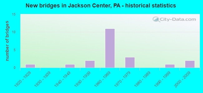
- New bridges - historical statistics
- 11920-1929
- 11940-1949
- 21950-1959
- 111960-1969
- 31970-1979
- 11990-1999
- 22000-2009

- Reconstructed bridges - Historical Statistics
- 11950-1959
- 01960-1969
- 01970-1979
- 21980-1989


- Bridge Condition - Deck
- 5.9%Very good
- 35.3%Good
- 41.2%Satisfactory
- 11.8%Fair
- 5.9%Poor

- Bridge Condition - Superstructure
- 17.6%Very good
- 29.4%Good
- 17.6%Satisfactory
- 17.6%Fair
- 5.9%Poor
- 5.9%Serious
- 5.9%Imminent failure

- Bridge Condition - Substructure
- 11.8%Very good
- 41.2%Good
- 23.5%Satisfactory
- 11.8%Fair
- 11.8%Poor

- Bridge Condition - Channel
- 28.6%Very good
- 21.4%Good
- 42.9%Satisfactory
- 7.1%Fair
Find on map >> Show street view
Structure Number: 25717, Location: JACKSON TOWNSHIP (Lat: 41.269244, Lng: -80.151617), Route carried "on" structure: US 62, Year Built: 1948, Status: Open, Structure Length: 1.52m (4.99ft), Average Daily Traffic: 3,862 (year 2020), Truck Traffic: 9%, Average Future Daily Traffic: 5,721 (year 2032), Design Load: HS 20, Features Intersected: OVER YELLOW CREEK
Minimum Vertical Clearance: 30+ m (98+ ft), Kilometerpoint: 33.420, Lanes on structure: 2, Base Highway Network: Yes, Owner: State Highway Agency, Approaching Roadway Width: 9.1m (29.9ft), Skew: 4 degrees, Material/Design: Concrete, Design/Construction: Tee Beam, Number Of Spans In Main Unit: 1, Length of Maximum Span: 14.3m (46.9ft), Curb or Sidewalk Widths: Left: 0.2m (0.7ft), Right: 0.2m (0.7ft), Curb-To-Curb Width: 11.7m (38.4ft), Out-to-Out Width: 12.6m (41.3ft)
Condition: Deck: Fair, Superstructure: Fair, Substructure: Poor, Channel: Satisfactory, Operating Rating: 60.8 metric tons, Method Used To Determine Operating Rating: Load Factor (LF), Inventory Rating: 36.3 metric tons, Method Used To Determine Inventory Rating: Load Factor (LF), Structural Evaluation: Meets minimum limits, Deck Geometry: Somewhat better than minimum adequacy, Waterway Adequacy: Superior to present desirable criteria, Approach Roadway Alignment: Equal to present desirable criteria, Length Of Structure Improvement: 1.50m (4.92ft), Designated Inspection Frequency: Every 24 months, Inspection Date: April 2021, Bridge Improvement Cost: $35,000, Roadway Improvement Cost: $103,000, Total Project Cost: $471,000, Wearing Surface/Protective System: Wearing Surface: Bituminous, Membrane: Preformed Fabric
Find on map >> Show street view
Structure Number: 25718, Location: JACKSON TOWNSHIP (Lat: 41.277353, Lng: -80.125319), Route carried "on" structure: US 62, Year Built: 1966, Status: Open, Structure Length: 0.94m (3.08ft), Average Daily Traffic: 2,715 (year 2022), Truck Traffic: 7%, Average Future Daily Traffic: 3,116 (year 2032), Design Load: HS 20, Features Intersected: OVER YELLOW CREEK
Minimum Vertical Clearance: 30+ m (98+ ft), Kilometerpoint: 35.840, Lanes on structure: 2, Base Highway Network: Yes, Owner: State Highway Agency, Approaching Roadway Width: 9.8m (32.2ft), Skew: 3 degrees, Material/Design: Prestressed concrete, Design/Construction: Box Beam or Girders - Multiple, Number Of Spans In Main Unit: 1, Length of Maximum Span: 9.1m (29.9ft), Curb-To-Curb Width: 12.2m (40.0ft), Out-to-Out Width: 14.0m (45.9ft)
Condition: Deck: Satisfactory, Superstructure: Good, Substructure: Satisfactory, Channel: Satisfactory, Operating Rating: 81.6 metric tons, Method Used To Determine Operating Rating: Load Factor (LF), Inventory Rating: 48.1 metric tons, Method Used To Determine Inventory Rating: Load Factor (LF), Structural Evaluation: Equal to present minimum criteria, Deck Geometry: Equal to present minimum criteria, Waterway Adequacy: Equal to present minimum criteria, Approach Roadway Alignment: Equal to present desirable criteria, Length Of Structure Improvement: 1.60m (5.25ft), Designated Inspection Frequency: Every 48 months, Inspection Date: April 2019, Deck Structure Type: Concrete Cast-file-Place, Wearing Surface/Protective System: Wearing Surface: Bituminous, Membrane: Preformed Fabric
Find on map >> Show street view
Structure Number: 25719, Location: JACKSON TOWNSHIP (Lat: 41.296372, Lng: -80.126319), Route carried "on" structure: US 62, Year Built: 1922, Year Reconstructed: 1961, Status: Open, Structure Length: 0.94m (3.08ft), Average Daily Traffic: 2,715 (year 2022), Truck Traffic: 7%, Average Future Daily Traffic: 3,116 (year 2032), Design Load: H 15, Features Intersected: OVER FOX RUN
Minimum Vertical Clearance: 30+ m (98+ ft), Kilometerpoint: 37.921, Lanes on structure: 2, Base Highway Network: Yes, Owner: State Highway Agency, Approaching Roadway Width: 9.1m (29.9ft), Material/Design: Concrete, Design/Construction: Tee Beam, Number Of Spans In Main Unit: 1, Length of Maximum Span: 8.8m (28.9ft), Curb-To-Curb Width: 12.6m (41.3ft), Out-to-Out Width: 13.1m (43.0ft)
Condition: Deck: Satisfactory, Superstructure: Fair, Substructure: Fair, Channel: Fair, Operating Rating: 55.3 metric tons, Method Used To Determine Operating Rating: Load Factor (LF), Inventory Rating: 30.8 metric tons, Method Used To Determine Inventory Rating: Load Factor (LF), Structural Evaluation: Somewhat better than minimum adequacy, Deck Geometry: Equal to present minimum criteria, Waterway Adequacy: Equal to present minimum criteria, Approach Roadway Alignment: Equal to present desirable criteria, Length Of Structure Improvement: 1.60m (5.25ft), Designated Inspection Frequency: Every 24 months, Inspection Date: October 2020, Bridge Improvement Cost: $6,000, Roadway Improvement Cost: $19,000, Total Project Cost: $86,000, Wearing Surface/Protective System: Wearing Surface: Bituminous, Membrane: Preformed Fabric
Find on map >> Show street view
Structure Number: 25749, Location: JACKSON TOWNSHIP (Lat: 41.278114, Lng: -80.161044), Route carried "on" structure: Interstate 79, Year Built: 1965, Year Reconstructed: 1988, Status: Open, Structure Length: 3.35m (10.99ft), Average Daily Traffic: 8,462 (year 2021), Truck Traffic: 19%, Average Future Daily Traffic: 9,924 (year 2032), Design Load: HS 20+Mod, Features Intersected: OVER SR 2017,N.FOSTER RD
Minimum Vertical Clearance: 30+ m (98+ ft), Kilometerpoint: 18.731, Lanes on structure: 2, Lanes under structure: 2, Base Highway Network: Yes, Owner: State Highway Agency, Approaching Roadway Width: 11.6m (38.1ft), Skew: 12 degrees, Material/Design: Prestressed concrete, Design/Construction: Box Beam or Girders - Single/Spread, Number Of Spans In Main Unit: 3, Length of Maximum Span: 12.8m (42.0ft), Curb or Sidewalk Widths: Left: 0.2m (0.7ft), Right: 0.2m (0.7ft), Curb-To-Curb Width: 13.1m (43.0ft), Out-to-Out Width: 13.9m (45.6ft)
Condition: Deck: Good, Superstructure: Good, Substructure: Satisfactory, Operating Rating: 89.8 metric tons, Method Used To Determine Operating Rating: Load Factor (LF), Inventory Rating: 42.6 metric tons, Method Used To Determine Inventory Rating: Load Factor (LF), Structural Evaluation: Equal to present minimum criteria, Deck Geometry: Superior to present desirable criteria, Underclear: Somewhat better than minimum adequacy, Approach Roadway Alignment: Equal to present desirable criteria, Length Of Structure Improvement: 4.20m (13.78ft), Designated Inspection Frequency: Every 24 months, Inspection Date: April 2021, Bridge Improvement Cost: $9,000, Roadway Improvement Cost: $27,000, Total Project Cost: $124,000, Deck Structure Type: Concrete Cast-file-Place, Wearing Surface/Protective System: Wearing Surface: Bituminous, Membrane: Preformed Fabric, Deck Protection: Epoxy Coated Reinforcing
Find on map >> Show street view
Structure Number: 2575, Location: JACKSON TOWNSHIP (Lat: 41.278325, Lng: -80.161378), Route carried "on" structure: Interstate 79, Year Built: 1965, Year Reconstructed: 1988, Status: Open, Structure Length: 3.35m (10.99ft), Average Daily Traffic: 8,370 (year 2021), Truck Traffic: 17%, Average Future Daily Traffic: 11,306 (year 2032), Design Load: HS 20+Mod, Features Intersected: OVER SR 2017,N.FOSTER RD
Minimum Vertical Clearance: 30+ m (98+ ft), Kilometerpoint: 18.723, Lanes on structure: 2, Lanes under structure: 2, Base Highway Network: Yes, Owner: State Highway Agency, Approaching Roadway Width: 11.6m (38.1ft), Skew: 12 degrees, Material/Design: Prestressed concrete, Design/Construction: Box Beam or Girders - Single/Spread, Number Of Spans In Main Unit: 3, Length of Maximum Span: 12.8m (42.0ft), Curb or Sidewalk Widths: Left: 0.2m (0.7ft), Right: 0.2m (0.7ft), Curb-To-Curb Width: 13.1m (43.0ft), Out-to-Out Width: 13.9m (45.6ft)
Condition: Deck: Good, Superstructure: Good, Substructure: Satisfactory, Operating Rating: 89.8 metric tons, Method Used To Determine Operating Rating: Load Factor (LF), Inventory Rating: 42.6 metric tons, Method Used To Determine Inventory Rating: Load Factor (LF), Structural Evaluation: Equal to present minimum criteria, Deck Geometry: Superior to present desirable criteria, Underclear: Better than present minimum criteria, Approach Roadway Alignment: Equal to present desirable criteria, Length Of Structure Improvement: 4.20m (13.78ft), Designated Inspection Frequency: Every 48 months, Inspection Date: April 2019, Deck Structure Type: Concrete Cast-file-Place, Wearing Surface/Protective System: Wearing Surface: Bituminous, Membrane: Preformed Fabric, Deck Protection: Epoxy Coated Reinforcing
Find on map >> Show street view
Structure Number: 25751, Location: JACKSON TOWNSHIP (Lat: 41.295681, Lng: -80.157961), Route carried "on" structure: State highway , Year Built: 1965, Status: Open, Structure Length: 6.95m (22.80ft), Average Daily Traffic: 180 (year 2022), Truck Traffic: 12%, Average Future Daily Traffic: 253 (year 2032), Design Load: HS 20, Features Intersected: OVER SR 79,NB/SB, Facility Carried by Structure: SR 2104,FOX MINE R
Minimum Vertical Clearance: 30+ m (98+ ft), Kilometerpoint: 0.000, Lanes on structure: 2, Lanes under structure: 8, Owner: State Highway Agency, Approaching Roadway Width: 5.5m (18.0ft), Material/Design: Prestressed concrete, Design/Construction: Box Beam or Girders - Single/Spread, Number Of Spans In Main Unit: 5, Length of Maximum Span: 18.0m (59.1ft), Curb or Sidewalk Widths: Left: 0.5m (1.6ft), Right: 0.5m (1.6ft), Curb-To-Curb Width: 8.5m (27.9ft), Out-to-Out Width: 10.2m (33.5ft)
Condition: Deck: Poor, Superstructure: Good, Substructure: Fair, Operating Rating: 81.6 metric tons, Method Used To Determine Operating Rating: Load Factor (LF), Inventory Rating: 36.3 metric tons, Method Used To Determine Inventory Rating: Load Factor (LF), Structural Evaluation: Somewhat better than minimum adequacy, Deck Geometry: Equal to present minimum criteria, Underclear: Somewhat better than minimum adequacy, Approach Roadway Alignment: Better than present minimum criteria, Length Of Structure Improvement: 6.90m (22.64ft), Designated Inspection Frequency: Every 24 months, Inspection Date: October 2020, Bridge Improvement Cost: $19,000, Roadway Improvement Cost: $55,000, Total Project Cost: $254,000, Deck Structure Type: Concrete Cast-file-Place, Wearing Surface/Protective System: Wearing Surface: Monolithic Concrete
Find on map >> Show street view
Structure Number: 25901, Location: JACKSON TOWNSHIP (Lat: 41.276764, Lng: -80.124475), Route carried "on" structure: State highway 965, Year Built: 1996, Status: Open, Structure Length: 1.04m (3.41ft), Average Daily Traffic: 1,301 (year 2021), Truck Traffic: 7%, Average Future Daily Traffic: 1,634 (year 2032), Design Load: HS 25 or greater, Features Intersected: OVER YELLOW CREEK
Minimum Vertical Clearance: 30+ m (98+ ft), Kilometerpoint: 0.000, Lanes on structure: 2, Owner: State Highway Agency, Approaching Roadway Width: 7.9m (25.9ft), Skew: 1 degrees, Material/Design: Prestressed concrete, Design/Construction: Box Beam or Girders - Single/Spread, Number Of Spans In Main Unit: 1, Length of Maximum Span: 9.8m (32.2ft), Curb or Sidewalk Widths: Left: 0.2m (0.7ft), Right: 0.2m (0.7ft), Curb-To-Curb Width: 8.6m (28.2ft), Out-to-Out Width: 9.7m (31.8ft)
Condition: Deck: Good, Superstructure: Very good, Substructure: Good, Channel: Good, Operating Rating: 71.7 metric tons, Method Used To Determine Operating Rating: Load Factor (LF), Inventory Rating: 45.4 metric tons, Method Used To Determine Inventory Rating: Load Factor (LF), Structural Evaluation: Better than present minimum criteria, Deck Geometry: Somewhat better than minimum adequacy, Waterway Adequacy: Equal to present minimum criteria, Approach Roadway Alignment: Equal to present desirable criteria, Length Of Structure Improvement: 1.70m (5.58ft), Designated Inspection Frequency: Every 48 months, Inspection Date: October 2020, Deck Structure Type: Concrete Cast-file-Place, Wearing Surface/Protective System: Wearing Surface: Bituminous, Membrane: Preformed Fabric, Deck Protection: Epoxy Coated Reinforcing
Find on map >> Show street view
Structure Number: 25967, Location: FINDLEY TOWNSHIP (Lat: 41.214750, Lng: -80.132425), Route carried "on" structure: State highway , Year Built: 1952, Status: Posted for load-capacity, Structure Length: 1.31m (4.30ft), Average Daily Traffic: 127 (year 2020), Truck Traffic: 5%, Average Future Daily Traffic: 208 (year 2032), Design Load: H 20, Features Intersected: OVER MILL CREEK, Facility Carried by Structure: SR 2016,CHURCH RD
Minimum Vertical Clearance: 30+ m (98+ ft), Kilometerpoint: 0.000, Lanes on structure: 2, Owner: State Highway Agency, Approaching Roadway Width: 5.5m (18.0ft), Material/Design: Steel, Design/Construction: Stringer/Multi-beam, Number Of Spans In Main Unit: 1, Length of Maximum Span: 12.5m (41.0ft), Curb or Sidewalk Widths: Left: 0.2m (0.7ft), Right: 0.2m (0.7ft), Curb-To-Curb Width: 6.7m (22.0ft), Out-to-Out Width: 7.3m (24.0ft)
Condition: Deck: Fair, Superstructure: Fair, Substructure: Good, Channel: Satisfactory, Operating Rating: 39.9 metric tons, Method Used To Determine Operating Rating: Load Factor (LF), Inventory Rating: 24.5 metric tons, Method Used To Determine Inventory Rating: Load Factor (LF), Structural Evaluation: Somewhat better than minimum adequacy, Deck Geometry: Meets minimum limits, Waterway Adequacy: Better than present minimum criteria, Approach Roadway Alignment: Equal to present desirable criteria, Bridge Posting: Required (Relationship of Operating Rating to Maximum Legal Load: 0.1 - 9.9% below), Length Of Structure Improvement: 2.00m (6.56ft), Designated Inspection Frequency: Every 24 months, Other Special Inspection Frequency: Every 12 months, Inspection Date: May 2021, Other Special Inspection Date: May 2021, Deck Structure Type: Closed Grating, Wearing Surface/Protective System: Wearing Surface: Bituminous
Find on map >> Show street view
Structure Number: 26116, Location: CHURCH RD.,FINDLEY TWP. (Lat: 41.225081, Lng: -80.139386), Route carried "on" structure: City street 7206, Year Built: 1975, Status: Open, Structure Length: 2.41m (7.91ft), Average Daily Traffic: 83 (year 2016), Truck Traffic: 4%, Average Future Daily Traffic: 120 (year 2036), Design Load: HS 20, Features Intersected: OVER MILL RUN, Facility Carried by Structure: BRIDGE 2619,T-776
Minimum Vertical Clearance: 30+ m (98+ ft), Kilometerpoint: 0.000, Lanes on structure: 2, Owner: County Highway Agency, Approaching Roadway Width: 7.3m (24.0ft), Skew: 4 degrees, Material/Design: Prestressed concrete, Design/Construction: Box Beam or Girders - Multiple, Number Of Spans In Main Unit: 1, Length of Maximum Span: 23.5m (77.1ft), Curb-To-Curb Width: 9.1m (29.9ft), Out-to-Out Width: 10.4m (34.1ft)
Condition: Deck: Good, Superstructure: Satisfactory, Substructure: Good, Channel: Satisfactory, Operating Rating: 71.7 metric tons, Method Used To Determine Operating Rating: Load Factor (LF), Inventory Rating: 25.4 metric tons, Method Used To Determine Inventory Rating: Load Factor (LF), Structural Evaluation: Equal to present minimum criteria, Deck Geometry: Better than present minimum criteria, Waterway Adequacy: Equal to present desirable criteria, Approach Roadway Alignment: Equal to present desirable criteria, Length Of Structure Improvement: 2.40m (7.87ft), Designated Inspection Frequency: Every 24 months, Inspection Date: July 2020, Total Project Cost: $2,171,000 ( Estimate for 2014), Deck Structure Type: Other, Wearing Surface/Protective System: Wearing Surface: Bituminous
Find on map >> Show street view
Structure Number: 26153, Location: S.FOSTER RD.,JACKSON TWP. (Lat: 41.267761, Lng: -80.152658), Route carried "on" structure: City street 7210, Year Built: 1958, Status: Open, Structure Length: 1.49m (4.89ft), Average Daily Traffic: 407 (year 2018), Truck Traffic: 4%, Average Future Daily Traffic: 570 (year 2038), Design Load: HS 20, Features Intersected: OVER YELLOW CREEK, Facility Carried by Structure: BRIDGE 2113,T-774
Minimum Vertical Clearance: 30+ m (98+ ft), Kilometerpoint: 0.000, Lanes on structure: 2, Owner: County Highway Agency, Approaching Roadway Width: 5.5m (18.0ft), Material/Design: Steel, Design/Construction: Stringer/Multi-beam, Number Of Spans In Main Unit: 1, Length of Maximum Span: 14.6m (47.9ft), Curb-To-Curb Width: 7.3m (24.0ft), Out-to-Out Width: 7.8m (25.6ft)
Condition: Deck: Satisfactory, Superstructure: Satisfactory, Substructure: Satisfactory, Channel: Good, Operating Rating: 52.6 metric tons, Method Used To Determine Operating Rating: Load Factor (LF), Inventory Rating: 31.8 metric tons, Method Used To Determine Inventory Rating: Load Factor (LF), Structural Evaluation: Equal to present minimum criteria, Deck Geometry: Meets minimum limits, Waterway Adequacy: Equal to present desirable criteria, Approach Roadway Alignment: Better than present minimum criteria, Length Of Structure Improvement: 1.50m (4.92ft), Designated Inspection Frequency: Every 24 months, Inspection Date: September 2020, Deck Structure Type: Open Grating
Find on map >> Show street view
Structure Number: 26154, Location: HOSACK RD,JACKSON TWP. (Lat: 41.294897, Lng: -80.151300), Route carried "on" structure: City street 7210, Year Built: 1965, Status: Posted for load, Structure Length: 0.85m (2.79ft), Average Daily Traffic: 375 (year 2019), Truck Traffic: 4%, Average Future Daily Traffic: 530 (year 2039), Design Load: HS 20, Features Intersected: OVER YELLOW CREEK, Facility Carried by Structure: BRIDGE 2107,T-784
Minimum Vertical Clearance: 30+ m (98+ ft), Kilometerpoint: 0.000, Lanes on structure: 2, Owner: County Highway Agency, Approaching Roadway Width: 5.5m (18.0ft), Material/Design: Steel, Design/Construction: Stringer/Multi-beam, Number Of Spans In Main Unit: 1, Length of Maximum Span: 7.6m (24.9ft), Curb-To-Curb Width: 8.5m (27.9ft), Out-to-Out Width: 9.1m (29.9ft)
Condition: Deck: Satisfactory, Superstructure: Poor, Substructure: Good, Channel: Very good, Operating Rating: 29.9 metric tons, Method Used To Determine Operating Rating: Load Factor (LF), Inventory Rating: 18.1 metric tons, Method Used To Determine Inventory Rating: Load Factor (LF), Structural Evaluation: Meets minimum limits, Deck Geometry: Equal to present minimum criteria, Waterway Adequacy: Better than present minimum criteria, Approach Roadway Alignment: Equal to present desirable criteria, Bridge Posting: Required (Relationship of Operating Rating to Maximum Legal Load: 10.0 - 19.9% below), Length Of Structure Improvement: 0.90m (2.95ft), Designated Inspection Frequency: Every 24 months, Other Special Inspection Frequency: Every 12 months, Inspection Date: September 2021, Other Special Inspection Date: September 2021, Total Project Cost: $971,000 ( Estimate for 2014), Deck Structure Type: Open Grating
Find on map >> Show street view
Structure Number: 26155, Location: HOSACK RD,JACKSON TWP. (Lat: 41.287036, Lng: -80.150772), Route carried "on" structure: City street 7210, Year Built: 1965, Status: Closed, Structure Length: 0.82m (2.69ft), Average Daily Traffic: 241 (year 2019), Truck Traffic: 4%, Average Future Daily Traffic: 340 (year 2039), Design Load: H 20, Features Intersected: OVER YELLOW CREEK BRANCH, Facility Carried by Structure: BRIDGE 2108,T-784
Minimum Vertical Clearance: 30+ m (98+ ft), Kilometerpoint: 0.000, Lanes on structure: 2, Owner: County Highway Agency, Approaching Roadway Width: 5.5m (18.0ft), Skew: 1 degrees, Material/Design: Steel, Design/Construction: Stringer/Multi-beam, Number Of Spans In Main Unit: 1, Length of Maximum Span: 7.6m (24.9ft), Curb-To-Curb Width: 8.5m (27.9ft), Out-to-Out Width: 9.1m (29.9ft)
Condition: Deck: Satisfactory, Superstructure: Imminent failure, Substructure: Poor, Channel: Satisfactory, Operating Rating: 20.9 metric tons, Method Used To Determine Operating Rating: Load Factor (LF), Inventory Rating: 12.7 metric tons, Method Used To Determine Inventory Rating: Load Factor (LF), Deck Geometry: Equal to present minimum criteria, Waterway Adequacy: Equal to present desirable criteria, Approach Roadway Alignment: Equal to present desirable criteria, Bridge Posting: Required (Relationship of Operating Rating to Maximum Legal Load: > 39.9% below), Length Of Structure Improvement: 0.80m (2.62ft), Designated Inspection Frequency: Every 24 months, Inspection Date: September 2021, Total Project Cost: $360,000 ( Estimate for 2014), Deck Structure Type: Open Grating
Find on map >> Show street view
Structure Number: 26156, Location: HOSACK ROAD,JACKSON TWP. (Lat: 41.277539, Lng: -80.148989), Route carried "on" structure: City street 7210, Year Built: 1965, Status: Open, Structure Length: 2.35m (7.71ft), Average Daily Traffic: 162 (year 2019), Truck Traffic: 4%, Average Future Daily Traffic: 230 (year 2039), Design Load: HS 20, Features Intersected: OVER YELLOW CREEK, Facility Carried by Structure: BRIDGE 2111,T-784
Minimum Vertical Clearance: 30+ m (98+ ft), Kilometerpoint: 0.000, Lanes on structure: 2, Owner: County Highway Agency, Approaching Roadway Width: 6.7m (22.0ft), Skew: 2 degrees, Material/Design: Steel, Design/Construction: Stringer/Multi-beam, Number Of Spans In Main Unit: 1, Length of Maximum Span: 22.3m (73.2ft), Curb-To-Curb Width: 8.5m (27.9ft), Out-to-Out Width: 9.6m (31.5ft)
Condition: Deck: Satisfactory, Superstructure: Serious, Substructure: Good, Channel: Good, Operating Rating: 46.3 metric tons, Method Used To Determine Operating Rating: Load Factor (LF), Inventory Rating: 28.1 metric tons, Method Used To Determine Inventory Rating: Load Factor (LF), Structural Evaluation: High priority of corrective action, Deck Geometry: Equal to present minimum criteria, Waterway Adequacy: Equal to present desirable criteria, Approach Roadway Alignment: Equal to present desirable criteria, Length Of Structure Improvement: 2.40m (7.87ft), Designated Inspection Frequency: Every 24 months, Other Special Inspection Frequency: Every 6 months, Inspection Date: September 2021, Other Special Inspection Date: September 2021, Total Project Cost: $2,002,000 ( Estimate for 2014), Deck Structure Type: Open Grating
Find on map >> Show street view
Structure Number: 26157, Location: CLARK ROAD,JACKSON TWP. (Lat: 41.283869, Lng: -80.139858), Route carried "on" structure: City street 7210, Year Built: 1976, Status: Open, Structure Length: 1.07m (3.51ft), Average Daily Traffic: 102 (year 2019), Truck Traffic: 4%, Average Future Daily Traffic: 140 (year 2039), Design Load: HS 20, Features Intersected: OVER FOX RUN, Facility Carried by Structure: BRIDGE 2109,T-786
Minimum Vertical Clearance: 30+ m (98+ ft), Kilometerpoint: 0.000, Lanes on structure: 2, Owner: County Highway Agency, Approaching Roadway Width: 6.1m (20.0ft), Material/Design: Steel, Design/Construction: Stringer/Multi-beam, Number Of Spans In Main Unit: 1, Length of Maximum Span: 9.8m (32.2ft), Curb-To-Curb Width: 9.1m (29.9ft), Out-to-Out Width: 10.4m (34.1ft)
Condition: Deck: Satisfactory, Superstructure: Satisfactory, Substructure: Very good, Channel: Satisfactory, Operating Rating: 59.0 metric tons, Method Used To Determine Operating Rating: Load Factor (LF), Inventory Rating: 35.4 metric tons, Method Used To Determine Inventory Rating: Load Factor (LF), Structural Evaluation: Equal to present minimum criteria, Deck Geometry: Equal to present minimum criteria, Waterway Adequacy: Equal to present desirable criteria, Approach Roadway Alignment: Equal to present desirable criteria, Length Of Structure Improvement: 1.00m (3.28ft), Designated Inspection Frequency: Every 24 months, Inspection Date: September 2021, Deck Structure Type: Concrete Cast-file-Place, Wearing Surface/Protective System: Wearing Surface: Monolithic Concrete
Find on map >> Show street view
Structure Number: 26158, Location: CLARK ROAD,JACKSON TWP. (Lat: 41.281492, Lng: -80.139003), Route carried "on" structure: City street 7210, Year Built: 1972, Status: Open, Structure Length: 0.82m (2.69ft), Average Daily Traffic: 154 (year 2018), Truck Traffic: 4%, Average Future Daily Traffic: 220 (year 2038), Design Load: HS 20, Features Intersected: OVER YELLOW CREEK, Facility Carried by Structure: BRIDGE 2110,T-786
Minimum Vertical Clearance: 30+ m (98+ ft), Kilometerpoint: 0.000, Lanes on structure: 2, Owner: County Highway Agency, Approaching Roadway Width: 6.7m (22.0ft), Material/Design: Prestressed concrete, Design/Construction: Box Beam or Girders - Multiple, Number Of Spans In Main Unit: 1, Length of Maximum Span: 7.6m (24.9ft), Curb-To-Curb Width: 9.1m (29.9ft), Out-to-Out Width: 10.4m (34.1ft)
Condition: Deck: Good, Superstructure: Good, Substructure: Good, Channel: Very good, Operating Rating: 82.6 metric tons, Method Used To Determine Operating Rating: Load Factor (LF), Inventory Rating: 49.0 metric tons, Method Used To Determine Inventory Rating: Load Factor (LF), Structural Evaluation: Better than present minimum criteria, Deck Geometry: Equal to present minimum criteria, Waterway Adequacy: Equal to present desirable criteria, Approach Roadway Alignment: Equal to present desirable criteria, Length Of Structure Improvement: 0.80m (2.62ft), Designated Inspection Frequency: Every 24 months, Inspection Date: July 2020, Deck Structure Type: Other, Wearing Surface/Protective System: Wearing Surface: Bituminous
Find on map >> Show street view
Structure Number: 42867, Location: FINDLEY TOWNSHIP (Lat: 41.230556, Lng: -80.151267), Route carried "on" structure: State highway , Year Built: 2005, Status: Open, Structure Length: 1.74m (5.71ft), Average Daily Traffic: 1,520 (year 2022), Truck Traffic: 6%, Average Future Daily Traffic: 1,668 (year 2032), Design Load: HS 25 or greater, Features Intersected: OVER MILL CREEK, Facility Carried by Structure: SR 2014,SCRUBGRASS
Minimum Vertical Clearance: 30+ m (98+ ft), Kilometerpoint: 5.684, Lanes on structure: 2, Owner: State Highway Agency, Approaching Roadway Width: 6.7m (22.0ft), Skew: 1 degrees, Material/Design: Steel, Design/Construction: Stringer/Multi-beam, Number Of Spans In Main Unit: 1, Length of Maximum Span: 14.6m (47.9ft), Curb-To-Curb Width: 8.6m (28.2ft), Out-to-Out Width: 9.8m (32.2ft)
Condition: Deck: Very good, Superstructure: Very good, Substructure: Good, Channel: Very good, Operating Rating: 94.3 metric tons, Method Used To Determine Operating Rating: Load Factor (LF), Inventory Rating: 56.2 metric tons, Method Used To Determine Inventory Rating: Load Factor (LF), Structural Evaluation: Better than present minimum criteria, Deck Geometry: Somewhat better than minimum adequacy, Waterway Adequacy: Better than present minimum criteria, Approach Roadway Alignment: Equal to present desirable criteria, Length Of Structure Improvement: 2.40m (7.87ft), Designated Inspection Frequency: Every 48 months, Inspection Date: December 2020, Deck Structure Type: Concrete Cast-file-Place, Wearing Surface/Protective System: Wearing Surface: Bituminous, Membrane: Preformed Fabric, Deck Protection: Epoxy Coated Reinforcing
Find on map >> Show street view
Structure Number: 4353, Location: FOX MINE RD.JACKSON TWP. (Lat: 41.297703, Lng: -80.150589), Route carried "on" structure: City street 7210, Year Built: 2006, Status: Open, Structure Length: 0.82m (2.69ft), Average Daily Traffic: 444 (year 2018), Truck Traffic: 4%, Average Future Daily Traffic: 620 (year 2038), Design Load: HL 93, Features Intersected: OVER UNNAMED TR.FOX RUN, Facility Carried by Structure: BRIDGE 2106
Minimum Vertical Clearance: 30+ m (98+ ft), Kilometerpoint: 0.000, Lanes on structure: 2, Owner: County Highway Agency, Approaching Roadway Width: 7.3m (24.0ft), Material/Design: Prestressed concrete, Design/Construction: Slab, Number Of Spans In Main Unit: 1, Length of Maximum Span: 7.6m (24.9ft), Curb-To-Curb Width: 7.6m (24.9ft), Out-to-Out Width: 8.6m (28.2ft)
Condition: Deck: Good, Superstructure: Very good, Substructure: Very good, Channel: Very good, Operating Rating: 89.8 metric tons, Method Used To Determine Operating Rating: Load and Resistance Factor (LRFR), Inventory Rating: 77.1 metric tons, Method Used To Determine Inventory Rating: Load and Resistance Factor (LRFR), Structural Evaluation: Equal to present desirable criteria, Deck Geometry: Meets minimum limits, Waterway Adequacy: Equal to present desirable criteria, Approach Roadway Alignment: Equal to present desirable criteria, Length Of Structure Improvement: 0.80m (2.62ft), Designated Inspection Frequency: Every 24 months, Inspection Date: September 2020, Deck Structure Type: Concrete Cast-file-Place, Wearing Surface/Protective System: Wearing Surface: Monolithic Concrete, Deck Protection: Epoxy Coated Reinforcing
Find on map >> Show street view
Structure Number: 25749, Location: JACKSON TOWNSHIP (Lat: 41.278114, Lng: -80.161044), Route carried "under" structure: State highway , Year Built: 1965, Structure Length: 0. m, Average Daily Traffic: 529 (year 2022), Truck Traffic: 4%, Features Intersected: OVER SR 2017,N.FOSTER RD, Facility Carried by Structure: SR 79,NB
Minimum Vertical Clearance: 4.35m (14.27ft), Kilometerpoint: 0.808, Lanes on structure: 2, Lanes under structure: 2, Material/Design: Prestressed concrete, Design/Construction: Box Beam or Girders - Single/Spread, Length of Maximum Span: 12.8m (42.0ft)
Find on map >> Show street view
Structure Number: 2575, Location: JACKSON TOWNSHIP (Lat: 41.278325, Lng: -80.161378), Route carried "under" structure: State highway , Year Built: 1965, Structure Length: 0. m, Average Daily Traffic: 529 (year 2022), Truck Traffic: 4%, Features Intersected: OVER SR 2017,N.FOSTER RD, Facility Carried by Structure: SR 79,SB
Minimum Vertical Clearance: 4.78m (15.68ft), Kilometerpoint: 0.808, Lanes on structure: 2, Lanes under structure: 2, Material/Design: Prestressed concrete, Design/Construction: Box Beam or Girders - Single/Spread, Length of Maximum Span: 12.8m (42.0ft)
Find on map >> Show street view
Structure Number: 25751, Location: JACKSON TOWNSHIP (Lat: 41.295681, Lng: -80.157961), Route carried "under" structure: Interstate 79, Year Built: 1965, Structure Length: 0. m, Average Daily Traffic: 8,462 (year 2021), Truck Traffic: 19%, Features Intersected: OVER SR 79,NB/SB, Facility Carried by Structure: SR 2104,FOX MINE R
Minimum Vertical Clearance: 5.05m (16.57ft), Kilometerpoint: 21.070, Lanes on structure: 2, Lanes under structure: 4, Material/Design: Prestressed concrete, Design/Construction: Box Beam or Girders - Single/Spread, Length of Maximum Span: 18.0m (59.1ft)
Find on map >> Show street view
Structure Number: 25751, Location: JACKSON TOWNSHIP (Lat: 41.295681, Lng: -80.157961), Route carried "under" structure: Interstate 79, Year Built: 1965, Structure Length: 0. m, Average Daily Traffic: 8,370 (year 2021), Truck Traffic: 17%, Features Intersected: OVER SR 79,NB/SB, Facility Carried by Structure: SR 2104,FOX MINE R
Minimum Vertical Clearance: 5.00m (16.40ft), Kilometerpoint: 21.057, Lanes on structure: 2, Lanes under structure: 4, Material/Design: Prestressed concrete, Design/Construction: Box Beam or Girders - Single/Spread, Length of Maximum Span: 18.0m (59.1ft)