Bridge Statistics for Ivyland, Pennsylvania (PA)
Condition, Traffic, Stress, Structural Evaluation, Project Costs
- National Bridge Inventory (NBI) Statistics
- 17Number of bridges
- 144ft / 44.3mTotal length
- $7,415,000Total costs
- 128,179Total average daily traffic
- 9,659Total average daily truck traffic
- National Bridge Inventory (NBI) Registered Bridges for Ivyland
- No street view available for this location
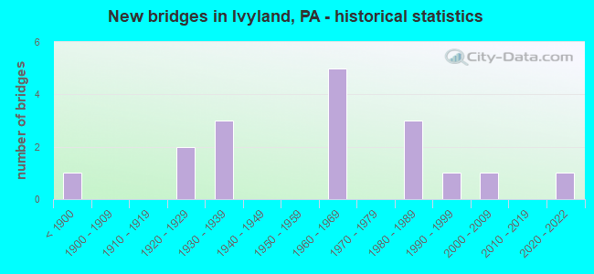
- New bridges - historical statistics
- 1Before 1900
- 21920-1929
- 31930-1939
- 51960-1969
- 31980-1989
- 11990-1999
- 12000-2009
- 12020-2022

- Reconstructed bridges - Historical Statistics
- 11980-1989
- 01990-1999
- 12000-2009
- 12010-2019


- Bridge Condition - Deck
- 9.1%Excellent
- 36.4%Good
- 18.2%Satisfactory
- 27.3%Fair
- 9.1%Poor

- Bridge Condition - Superstructure
- 15.4%Very good
- 15.4%Good
- 30.8%Satisfactory
- 23.1%Fair
- 7.7%Poor
- 7.7%Imminent failure

- Bridge Condition - Substructure
- 7.7%Very good
- 15.4%Good
- 23.1%Satisfactory
- 38.5%Fair
- 15.4%Poor

- Bridge Condition - Channel
- 7.7%Good
- 15.4%Satisfactory
- 23.1%Fair
- 53.8%Poor

- Bridge Condition - Culverts
- 50.0%Good
- 50.0%Satisfactory
Find on map >> Show street view
Structure Number: 6959, Location: .7MI.TO LR-09046 29G13 (Lat: 40.234383, Lng: -75.091039), Route carried "on" structure: State highway 263, Year Built: 1967, Year Reconstructed: 2017, Status: Open, Structure Length: 6.55m (21.49ft), Average Daily Traffic: 19,894 (year 2022), Truck Traffic: 4%, Average Future Daily Traffic: 24,537 (year 2032), Design Load: HS 20, Features Intersected: LITTLE NESHAMINY CR & RD, Facility Carried by Structure: YORK ROAD
Minimum Vertical Clearance: 30+ m (98+ ft), Kilometerpoint: 5.105, Lanes on structure: 2, Lanes under structure: 2, Base Highway Network: Yes, Owner: State Highway Agency, Approaching Roadway Width: 21.6m (70.9ft), Skew: 22 degrees, Material/Design: Prestressed concrete, Design/Construction: Box Beam or Girders - Single/Spread, Number Of Spans In Main Unit: 3, Length of Maximum Span: 23.8m (78.1ft), Curb-To-Curb Width: 20.7m (67.9ft), Out-to-Out Width: 21.9m (71.9ft)
Condition: Deck: Good, Superstructure: Good, Substructure: Good, Channel: Fair, Operating Rating: 50.8 metric tons, Method Used To Determine Operating Rating: Load Factor (LF), Inventory Rating: 29.0 metric tons, Method Used To Determine Inventory Rating: Load Factor (LF), Structural Evaluation: Better than present minimum criteria, Deck Geometry: Superior to present desirable criteria, Underclear: Meets minimum limits, Waterway Adequacy: Superior to present desirable criteria, Approach Roadway Alignment: Equal to present desirable criteria, Length Of Structure Improvement: 7.50m (24.61ft), Designated Inspection Frequency: Every 24 months, Inspection Date: April 2021, Bridge Improvement Cost: $78,000, Roadway Improvement Cost: $230,000, Total Project Cost: $1,053,000, Deck Structure Type: Concrete Cast-file-Place, Wearing Surface/Protective System: Wearing Surface: Latex Concrete
Find on map >> Show street view
Structure Number: 7027, Location: LANGHORNE 37C11 (Lat: 40.171117, Lng: -74.914800), Route carried "on" structure: State highway 413, Year Built: 1965, Status: Open, Structure Length: 4.15m (13.62ft), Average Daily Traffic: 10,942 (year 2020), Truck Traffic: 4%, Average Future Daily Traffic: 19,022 (year 2032), Design Load: HS 20, Features Intersected: US 1, Facility Carried by Structure: PINE STREET
Minimum Vertical Clearance: 30+ m (98+ ft), Kilometerpoint: 12.245, Lanes on structure: 2, Lanes under structure: 4, Base Highway Network: Yes, Owner: State Highway Agency, Approaching Roadway Width: 20.7m (67.9ft), Skew: 21 degrees, Material/Design: Prestressed concrete, Design/Construction: Box Beam or Girders - Single/Spread, Number Of Spans In Main Unit: 3, Length of Maximum Span: 25.3m (83.0ft), Curb or Sidewalk Widths: Left: 0.4m (1.3ft), Right: 0.4m (1.3ft), Curb-To-Curb Width: 20.7m (67.9ft), Out-to-Out Width: 21.5m (70.5ft)
Condition: Deck: Satisfactory, Superstructure: Poor, Substructure: Poor, Operating Rating: 59.0 metric tons, Method Used To Determine Operating Rating: Load Factor (LF), Inventory Rating: 20.9 metric tons, Method Used To Determine Inventory Rating: Load Factor (LF), Structural Evaluation: Meets minimum limits, Deck Geometry: Superior to present desirable criteria, Underclear: High priority of replacement, Approach Roadway Alignment: Equal to present desirable criteria, Length Of Structure Improvement: 5.00m (16.40ft), Designated Inspection Frequency: Every 24 months, Inspection Date: March 2021, Bridge Improvement Cost: $293,000, Roadway Improvement Cost: $863,000, Total Project Cost: $3,956,000, Deck Structure Type: Concrete Cast-file-Place, Wearing Surface/Protective System: Wearing Surface: Monolithic Concrete
Find on map >> Show street view
Structure Number: 721, Location: 1/4 W.IVYLAND BORO.34J03 (Lat: 40.216503, Lng: -75.074847), Route carried "on" structure: State highway , Year Built: 1923, Status: Open, Structure Length: 1.49m (4.89ft), Average Daily Traffic: 17,880 (year 2022), Truck Traffic: 5%, Average Future Daily Traffic: 22,729 (year 2032), Design Load: H 20, Features Intersected: BR.LITTLE NESHAMINY CR., Facility Carried by Structure: BRISTOL ROAD
Minimum Vertical Clearance: 30+ m (98+ ft), Kilometerpoint: 13.391, Lanes on structure: 2, Owner: State Highway Agency, Approaching Roadway Width: 7.9m (25.9ft), Material/Design: Steel, Design/Construction: Stringer/Multi-beam, Number Of Spans In Main Unit: 2, Length of Maximum Span: 6.1m (20.0ft), Curb-To-Curb Width: 6.1m (20.0ft), Out-to-Out Width: 6.9m (22.6ft)
Condition: Deck: Fair, Superstructure: Fair, Substructure: Fair, Channel: Poor, Operating Rating: 55.3 metric tons, Method Used To Determine Operating Rating: Field evaluation and documented engineering judgment, Inventory Rating: 32.7 metric tons, Method Used To Determine Inventory Rating: Field evaluation and documented engineering judgment, Structural Evaluation: Somewhat better than minimum adequacy, Deck Geometry: High priority of replacement, Waterway Adequacy: Better than present minimum criteria, Approach Roadway Alignment: Equal to present desirable criteria, Length Of Structure Improvement: 2.20m (7.22ft), Designated Inspection Frequency: Every 24 months, Inspection Date: April 2021, Bridge Improvement Cost: $40,000, Roadway Improvement Cost: $119,000, Total Project Cost: $545,000, Deck Structure Type: Concrete Cast-file-Place, Wearing Surface/Protective System: Wearing Surface: Bituminous
Find on map >> Show street view
Structure Number: 7326, Location: 1MI.N.ALMSHOUSE RD.34K02 (Lat: 40.224078, Lng: -75.070294), Route carried "on" structure: State highway , Year Built: 1927, Status: Open, Structure Length: 1.52m (4.99ft), Average Daily Traffic: 3,826 (year 2022), Truck Traffic: 17%, Average Future Daily Traffic: 5,074 (year 2032), Design Load: H 20, Features Intersected: BRANCH LITTLE NESHAMINY, Facility Carried by Structure: MEARNS ROAD
Minimum Vertical Clearance: 30+ m (98+ ft), Kilometerpoint: 3.087, Lanes on structure: 2, Owner: State Highway Agency, Approaching Roadway Width: 7.3m (24.0ft), Material/Design: Concrete, Design/Construction: Tee Beam, Number Of Spans In Main Unit: 1, Length of Maximum Span: 14.0m (45.9ft), Curb-To-Curb Width: 6.2m (20.3ft), Out-to-Out Width: 6.9m (22.6ft)
Condition: Deck: Poor, Superstructure: Fair, Substructure: Fair, Channel: Poor, Operating Rating: 54.4 metric tons, Method Used To Determine Operating Rating: Load Factor (LF), Inventory Rating: 32.7 metric tons, Method Used To Determine Inventory Rating: Load Factor (LF), Structural Evaluation: Somewhat better than minimum adequacy, Deck Geometry: High priority of replacement, Waterway Adequacy: Equal to present minimum criteria, Approach Roadway Alignment: Equal to present desirable criteria, Length Of Structure Improvement: 2.20m (7.22ft), Designated Inspection Frequency: Every 24 months, Inspection Date: April 2021, Bridge Improvement Cost: $40,000, Roadway Improvement Cost: $119,000, Total Project Cost: $545,000, Deck Structure Type: Concrete Cast-file-Place, Wearing Surface/Protective System: Wearing Surface: Monolithic Concrete, Deck Protection: Epoxy Coated Reinforcing
Find on map >> Show street view
Structure Number: 7327, Location: 400'ALMSHOUSE RD. 30B12 (Lat: 40.236694, Lng: -75.059133), Route carried "on" structure: State highway , Year Built: 1934, Status: Open, Structure Length: 0.76m (2.49ft), Average Daily Traffic: 3,826 (year 2022), Truck Traffic: 17%, Average Future Daily Traffic: 5,074 (year 2032), Design Load: H 20, Features Intersected: BRANCH LITTLE NESHAMINY, Facility Carried by Structure: MEARNS ROAD
Minimum Vertical Clearance: 30+ m (98+ ft), Kilometerpoint: 3.920, Lanes on structure: 2, Owner: State Highway Agency, Approaching Roadway Width: 6.7m (22.0ft), Skew: 3 degrees, Material/Design: Concrete, Design/Construction: Tee Beam, Number Of Spans In Main Unit: 1, Length of Maximum Span: 7.3m (24.0ft), Curb-To-Curb Width: 7.2m (23.6ft), Out-to-Out Width: 7.9m (25.9ft)
Condition: Deck: Fair, Superstructure: Fair, Substructure: Poor, Channel: Poor, Operating Rating: 52.6 metric tons, Method Used To Determine Operating Rating: Load Factor (LF), Inventory Rating: 31.8 metric tons, Method Used To Determine Inventory Rating: Load Factor (LF), Structural Evaluation: Meets minimum limits, Deck Geometry: High priority of replacement, Waterway Adequacy: Equal to present minimum criteria, Approach Roadway Alignment: Equal to present desirable criteria, Length Of Structure Improvement: 1.50m (4.92ft), Designated Inspection Frequency: Every 24 months, Inspection Date: April 2021, Bridge Improvement Cost: $31,000, Roadway Improvement Cost: $92,000, Total Project Cost: $422,000, Deck Structure Type: Concrete Cast-file-Place, Wearing Surface/Protective System: Wearing Surface: Bituminous
Find on map >> Show street view
Structure Number: 7494, Location: WARMINSTER TWP 34J04 (Lat: 40.209928, Lng: -75.078067), Route carried "on" structure: City street , Year Built: 1984, Status: Open, Structure Length: 0.91m (2.99ft), Average Daily Traffic: 750 (year 1998), Average Future Daily Traffic: 1,050 (year 2011), Design Load: HS 20, Features Intersected: BRANCH LITTLE NESHAMINY, Facility Carried by Structure: IVYLAND ROAD
Minimum Vertical Clearance: 30+ m (98+ ft), Kilometerpoint: 0.000, Lanes on structure: 2, Owner: County Highway Agency, Approaching Roadway Width: 10.1m (33.1ft), Skew: 3 degrees, Material/Design: Prestressed concrete, Design/Construction: Box Beam or Girders - Multiple, Number Of Spans In Main Unit: 1, Length of Maximum Span: 9.1m (29.9ft), Curb or Sidewalk Widths: Left: 0.2m (0.7ft), Right: 0.2m (0.7ft), Curb-To-Curb Width: 10.4m (34.1ft), Out-to-Out Width: 11.6m (38.1ft)
Condition: Deck: Fair, Superstructure: Satisfactory, Substructure: Fair, Channel: Poor, Inventory Rating: 61.7 metric tons, Method Used To Determine Inventory Rating: Load Factor (LF), Structural Evaluation: Somewhat better than minimum adequacy, Deck Geometry: Equal to present minimum criteria, Waterway Adequacy: Equal to present desirable criteria, Approach Roadway Alignment: Equal to present desirable criteria, Length Of Structure Improvement: 1.60m (5.25ft), Designated Inspection Frequency: Every 24 months, Inspection Date: March 2020, Deck Structure Type: Concrete Cast-file-Place, Wearing Surface/Protective System: Wearing Surface: Monolithic Concrete
Find on map >> Show street view
Structure Number: 7529, Location: 1 Mi E SR263 ADC 3035J7 (Lat: 40.269536, Lng: -75.073844), Route carried "on" structure: City street , Year Built: 1888, Status: Closed, Structure Length: 8.84m (29.00ft), Average Daily Traffic: 50 (year 1998), Average Future Daily Traffic: 70 (year 2011), Features Intersected: NESHAMINY CREEK, Facility Carried by Structure: MILL ROAD
Minimum Vertical Clearance: 30+ m (98+ ft), Kilometerpoint: 0.000, Lanes on structure: 1, Owner: County Highway Agency, Approaching Roadway Width: 4.0m (13.1ft), Skew: 1 degrees, Material/Design: Steel, Design/Construction: Truss - Thru, Number Of Spans In Main Unit: 2, Length of Maximum Span: 43.6m (143.0ft), Curb-To-Curb Width: 4.7m (15.4ft), Out-to-Out Width: 4.7m (15.4ft)
Condition: Deck: Good, Superstructure: Imminent failure, Substructure: Fair, Channel: Poor, Deck Geometry: Better than present minimum criteria, Waterway Adequacy: Equal to present minimum criteria, Approach Roadway Alignment: Better than present minimum criteria, Bridge Posting: Required (Relationship of Operating Rating to Maximum Legal Load: > 39.9% below), Length Of Structure Improvement: 9.80m (32.15ft), Designated Inspection Frequency: Every 24 months, Critical Feature Inspection Frequency: Every 6 months, Other Special Inspection Frequency: Every 6 months, Inspection Date: July 2020, Critical Feature Inspection Date: July 2020, Other Special Inspection Date: July 2020, Bridge Improvement Cost: $52,000, Roadway Improvement Cost: $153,000, Total Project Cost: $702,000, Deck Structure Type: Open Grating
Find on map >> Show street view
Structure Number: 7649, Location: .5MI.N HARTSVILLE 3147-F3 (Lat: 40.235100, Lng: -75.092900), Route carried "on" structure: City street , Year Built: 1930, Year Reconstructed: 2000, Status: Open, Structure Length: 2.53m (8.30ft), Average Daily Traffic: 400 (year 2017), Truck Traffic: 5%, Average Future Daily Traffic: 1,060 (year 2037), Design Load: HS 20, Features Intersected: LITTLE NESHAMINY CREEK, Facility Carried by Structure: OLD YORK ROAD
Minimum Vertical Clearance: 30+ m (98+ ft), Kilometerpoint: 0.000, Lanes on structure: 2, Owner: Town or Township Highway Agency, Approaching Roadway Width: 6.1m (20.0ft), Material/Design: Steel, Design/Construction: Stringer/Multi-beam, Number Of Spans In Main Unit: 1, Length of Maximum Span: 23.8m (78.1ft), Curb-To-Curb Width: 8.4m (27.6ft), Out-to-Out Width: 9.4m (30.8ft)
Condition: Deck: Good, Superstructure: Good, Substructure: Satisfactory, Channel: Satisfactory, Operating Rating: 69.9 metric tons, Method Used To Determine Operating Rating: Load Factor (LF), Inventory Rating: 41.7 metric tons, Method Used To Determine Inventory Rating: Load Factor (LF), Structural Evaluation: Equal to present minimum criteria, Deck Geometry: Somewhat better than minimum adequacy, Waterway Adequacy: Equal to present desirable criteria, Approach Roadway Alignment: Equal to present desirable criteria, Length Of Structure Improvement: 3.10m (10.17ft), Designated Inspection Frequency: Every 24 months, Inspection Date: July 2019, Deck Structure Type: Concrete Cast-file-Place, Wearing Surface/Protective System: Wearing Surface: Monolithic Concrete, Deck Protection: Epoxy Coated Reinforcing
Find on map >> Show street view
Structure Number: 765, Location: 2MI.W.NAVALAIR ST 3147-J4 (Lat: 40.226300, Lng: -75.069397), Route carried "on" structure: Business City street , Year Built: 1980, Status: Open, Structure Length: 1.49m (4.89ft), Average Daily Traffic: 400 (year 2017), Truck Traffic: 3%, Average Future Daily Traffic: 1,060 (year 2037), Features Intersected: TRIB.LITTLE NESHAMINY CR, Facility Carried by Structure: SYCAMORE DRIVE
Minimum Vertical Clearance: 30+ m (98+ ft), Kilometerpoint: 0.000, Lanes on structure: 2, Owner: Town or Township Highway Agency, Approaching Roadway Width: 13.7m (44.9ft), Material/Design: Steel, Design/Construction: Arch - Deck, Number Of Spans In Main Unit: 2, Length of Maximum Span: 7.0m (23.0ft), Curb-To-Curb Width: 13.2m (43.3ft), Out-to-Out Width: 14.1m (46.3ft)
Condition: Superstructure: Satisfactory, Substructure: Satisfactory, Channel: Fair, Operating Rating: 49.0 metric tons, Method Used To Determine Operating Rating: Field evaluation and documented engineering judgment, Inventory Rating: 32.7 metric tons, Method Used To Determine Inventory Rating: Field evaluation and documented engineering judgment, Structural Evaluation: Equal to present minimum criteria, Deck Geometry: Superior to present desirable criteria, Waterway Adequacy: Better than present minimum criteria, Approach Roadway Alignment: Equal to present desirable criteria, Length Of Structure Improvement: 1.90m (6.23ft), Designated Inspection Frequency: Every 24 months, Inspection Date: July 2019
Find on map >> Show street view
Structure Number: 13001, Location: VERNON TOWNSHIP (Lat: 41.652392, Lng: -80.204644), Route carried "on" structure: Interstate 79, Year Built: 1969, Year Reconstructed: 1994, Status: Open, Structure Length: 3.47m (11.38ft), Average Daily Traffic: 7,747 (year 2021), Truck Traffic: 20%, Average Future Daily Traffic: 10,671 (year 2032), Design Load: HS 20+Mod, Features Intersected: OVER SR 0102
Minimum Vertical Clearance: 30+ m (98+ ft), Kilometerpoint: 20.955, Lanes on structure: 2, Lanes under structure: 2, Base Highway Network: Yes, Owner: State Highway Agency, Approaching Roadway Width: 11.6m (38.1ft), Skew: 12 degrees, Material/Design: Prestressed concrete, Design/Construction: Box Beam or Girders - Single/Spread, Number Of Spans In Main Unit: 3, Length of Maximum Span: 13.1m (43.0ft), Curb or Sidewalk Widths: Left: 0.2m (0.7ft), Right: 0.2m (0.7ft), Curb-To-Curb Width: 11.9m (39.0ft), Out-to-Out Width: 13.1m (43.0ft)
Condition: Deck: Satisfactory, Superstructure: Satisfactory, Substructure: Satisfactory, Operating Rating: 87.1 metric tons, Method Used To Determine Operating Rating: Load Factor (LF), Inventory Rating: 39.9 metric tons, Method Used To Determine Inventory Rating: Load Factor (LF), Structural Evaluation: Equal to present minimum criteria, Deck Geometry: Equal to present minimum criteria, Underclear: Better than present minimum criteria, Approach Roadway Alignment: Equal to present desirable criteria, Length Of Structure Improvement: 3.50m (11.48ft), Designated Inspection Frequency: Every 24 months, Inspection Date: October 2020, Bridge Improvement Cost: $14,000, Roadway Improvement Cost: $42,000, Total Project Cost: $192,000, Deck Structure Type: Concrete Cast-file-Place, Wearing Surface/Protective System: Wearing Surface: Bituminous, Membrane: Preformed Fabric
Find on map >> Show street view
Structure Number: 40483, Location: .5MI W.JAMISON 3035-D10 (Lat: 40.254525, Lng: -75.100756), Route carried "on" structure: City street , Year Built: 1986, Status: Open, Structure Length: 0.76m (2.49ft), Average Daily Traffic: 250 (year 2017), Truck Traffic: 2%, Average Future Daily Traffic: 300 (year 2037), Design Load: H 20, Features Intersected: FISH CREEK, Facility Carried by Structure: SUNRISE WAY
Minimum Vertical Clearance: 30+ m (98+ ft), Kilometerpoint: 0.000, Lanes on structure: 2, Owner: Town or Township Highway Agency, Approaching Roadway Width: 7.9m (25.9ft), Material/Design: Concrete, Design/Construction: Culvert, Number Of Spans In Main Unit: 2, Length of Maximum Span: 7.6m (24.9ft), Curb-To-Curb Width: 7.9m (25.9ft), Out-to-Out Width: 16.2m (53.1ft)
Condition: Channel: Poor, Culverts: Satisfactory, Operating Rating: 49.0 metric tons, Method Used To Determine Operating Rating: Field evaluation and documented engineering judgment, Inventory Rating: 32.7 metric tons, Method Used To Determine Inventory Rating: Field evaluation and documented engineering judgment, Structural Evaluation: Equal to present minimum criteria, Deck Geometry: Somewhat better than minimum adequacy, Waterway Adequacy: Equal to present desirable criteria, Approach Roadway Alignment: Equal to present desirable criteria, Length Of Structure Improvement: 1.50m (4.92ft), Designated Inspection Frequency: Every 24 months, Inspection Date: March 2020
Find on map >> Show street view
Structure Number: 40485, Location: 1.1 MI NE SR2039 3036-A10 (Lat: 40.258200, Lng: -75.057597), Route carried "on" structure: City street , Year Built: 1935, Status: Open, Structure Length: 0.67m (2.20ft), Average Daily Traffic: 105 (year 2017), Truck Traffic: 1%, Average Future Daily Traffic: 120 (year 2037), Design Load: H 20, Features Intersected: TRIB.NESHAMINY CREEK, Facility Carried by Structure: DARK HOLLOW ROAD
Minimum Vertical Clearance: 30+ m (98+ ft), Kilometerpoint: 0.000, Lanes on structure: 2, Owner: Town or Township Highway Agency, Approaching Roadway Width: 5.5m (18.0ft), Skew: 3 degrees, Material/Design: Masonry, Design/Construction: Arch - Deck, Number Of Spans In Main Unit: 2, Length of Maximum Span: 3.0m (9.8ft), Curb or Sidewalk Widths: Left: 0.3m (1.0ft), Right: 0.3m (1.0ft), Curb-To-Curb Width: 9.4m (30.8ft), Out-to-Out Width: 10.4m (34.1ft)
Condition: Superstructure: Satisfactory, Substructure: Fair, Channel: Poor, Operating Rating: 48.1 metric tons, Method Used To Determine Operating Rating: Field evaluation and documented engineering judgment, Inventory Rating: 28.1 metric tons, Method Used To Determine Inventory Rating: Field evaluation and documented engineering judgment, Structural Evaluation: Somewhat better than minimum adequacy, Deck Geometry: Equal to present minimum criteria, Waterway Adequacy: Equal to present desirable criteria, Approach Roadway Alignment: Equal to present desirable criteria, Length Of Structure Improvement: 1.30m (4.27ft), Designated Inspection Frequency: Every 24 months, Inspection Date: April 2020
Find on map >> Show street view
Structure Number: 40736, Location: VILLAGE HARTSVILLE 29E13 (Lat: 40.232842, Lng: -75.102733), Route carried "on" structure: State highway , Year Built: 1999, Status: Open, Structure Length: 9.11m (29.89ft), Average Daily Traffic: 11,806 (year 2022), Truck Traffic: 4%, Average Future Daily Traffic: 17,529 (year 2032), Design Load: HS 25 or greater, Features Intersected: LITTLE NESHAMINY CREEK, Facility Carried by Structure: BRISTOL ROAD
Minimum Vertical Clearance: 30+ m (98+ ft), Kilometerpoint: 10.363, Lanes on structure: 2, Owner: State Highway Agency, Approaching Roadway Width: 10.7m (35.1ft), Skew: 7 degrees, Material/Design: Steel continuous, Design/Construction: Stringer/Multi-beam, Number Of Spans In Main Unit: 3, Length of Maximum Span: 34.4m (112.9ft), Curb or Sidewalk Widths: Left: 0.2m (0.7ft), Right: 0.2m (0.7ft), Curb-To-Curb Width: 10.4m (34.1ft), Out-to-Out Width: 11.4m (37.4ft)
Condition: Deck: Good, Superstructure: Very good, Substructure: Good, Channel: Fair, Operating Rating: 65.3 metric tons, Method Used To Determine Operating Rating: Load Factor (LF), Inventory Rating: 39.0 metric tons, Method Used To Determine Inventory Rating: Load Factor (LF), Structural Evaluation: Better than present minimum criteria, Deck Geometry: Meets minimum limits, Waterway Adequacy: Equal to present minimum criteria, Approach Roadway Alignment: Equal to present desirable criteria, Length Of Structure Improvement: 9.80m (32.15ft), Designated Inspection Frequency: Every 24 months, Inspection Date: December 2019, Deck Structure Type: Concrete Cast-file-Place, Wearing Surface/Protective System: Wearing Surface: Latex Concrete, Deck Protection: Epoxy Coated Reinforcing
Find on map >> Show street view
Structure Number: 41225, Location: .1MI E WARRINGTON 29G09 (Lat: 40.256714, Lng: -75.092306), Route carried "on" structure: State highway , Year Built: 2001, Status: Open, Structure Length: 0.79m (2.59ft), Average Daily Traffic: 10,850 (year 2021), Truck Traffic: 6%, Average Future Daily Traffic: 13,625 (year 2032), Design Load: HS 25 or greater, Features Intersected: BRANCH LITTLE NESHAMINY, Facility Carried by Structure: ALMSHOUSE ROAD
Minimum Vertical Clearance: 30+ m (98+ ft), Kilometerpoint: 4.268, Lanes on structure: 2, Owner: State Highway Agency, Approaching Roadway Width: 11.6m (38.1ft), Skew: 1 degrees, Material/Design: Concrete, Design/Construction: Culvert, Number Of Spans In Main Unit: 1, Length of Maximum Span: 7.6m (24.9ft), Curb or Sidewalk Widths: Left: 0.2m (0.7ft), Right: 0.2m (0.7ft), Curb-To-Curb Width: 11.6m (38.1ft), Out-to-Out Width: 13.7m (44.9ft)
Condition: Channel: Satisfactory, Culverts: Good, Operating Rating: 83.5 metric tons, Method Used To Determine Operating Rating: Field evaluation and documented engineering judgment, Inventory Rating: 49.9 metric tons, Method Used To Determine Inventory Rating: Field evaluation and documented engineering judgment, Structural Evaluation: Better than present minimum criteria, Deck Geometry: Somewhat better than minimum adequacy, Waterway Adequacy: Better than present minimum criteria, Approach Roadway Alignment: Equal to present desirable criteria, Designated Inspection Frequency: Every 24 months, Inspection Date: August 2020, Wearing Surface/Protective System: Wearing Surface: Monolithic Concrete
Find on map >> Show street view
Structure Number: 68216, Location: 1.2 Mi W of PA263 3147-J3 (Lat: 40.233583, Lng: -75.071597), Route carried "on" structure: City street , Year Built: 2021, Status: Open, Structure Length: 1.28m (4.20ft), Average Daily Traffic: 400 (year 2001), Truck Traffic: 1%, Average Future Daily Traffic: 450 (year 2015), Design Load: HL 93, Features Intersected: LITTLE NESHAMINY CREEK, Facility Carried by Structure: CREEK ROAD
Minimum Vertical Clearance: 30+ m (98+ ft), Kilometerpoint: 0.000, Lanes on structure: 2, Owner: County Highway Agency, Approaching Roadway Width: 7.3m (24.0ft), Material/Design: Prestressed concrete, Design/Construction: Box Beam or Girders - Single/Spread, Number Of Spans In Main Unit: 1, Length of Maximum Span: 12.8m (42.0ft), Curb-To-Curb Width: 7.3m (24.0ft), Out-to-Out Width: 8.2m (26.9ft)
Condition: Deck: Excellent, Superstructure: Very good, Substructure: Very good, Channel: Good, Operating Rating: 45.4 metric tons, Method Used To Determine Operating Rating: Assigned ratings based on Load and Resistance Factor Design (LRFD) reported by rating factor (RF) using HL93 loadings, Inventory Rating: 35.0 metric tons, Method Used To Determine Inventory Rating: Assigned ratings based on Load and Resistance Factor Design (LRFD) reported by rating factor (RF) using HL93 loadings, Structural Evaluation: Equal to present desirable criteria, Deck Geometry: Somewhat better than minimum adequacy, Waterway Adequacy: Equal to present minimum criteria, Approach Roadway Alignment: Equal to present desirable criteria, Designated Inspection Frequency: Every 24 months, Inspection Date: August 2021, Deck Structure Type: Concrete Cast-file-Place, Wearing Surface/Protective System: Wearing Surface: Monolithic Concrete, Deck Protection: Epoxy Coated Reinforcing
Find on map >> Show street view
Structure Number: 7027, Location: LANGHORNE 37C11 (Lat: 40.171117, Lng: -74.914800), Route carried "under" structure: US 1, Year Built: 1965, Structure Length: 0. m, Average Daily Traffic: 19,313 (year 2020), Truck Traffic: 8%, Features Intersected: US 1, Facility Carried by Structure: PINE STREET
Minimum Vertical Clearance: 4.34m (14.24ft), Kilometerpoint: 7.722, Lanes on structure: 2, Lanes under structure: 2, Material/Design: Prestressed concrete, Design/Construction: Box Beam or Girders - Single/Spread, Length of Maximum Span: 25.3m (83.0ft)
Find on map >> Show street view
Structure Number: 7027, Location: LANGHORNE 37C11 (Lat: 40.171117, Lng: -74.914800), Route carried "under" structure: US 1, Year Built: 1965, Structure Length: 0. m, Average Daily Traffic: 19,740 (year 2020), Truck Traffic: 10%, Features Intersected: US 1, Facility Carried by Structure: PINE STREET
Minimum Vertical Clearance: 4.34m (14.24ft), Kilometerpoint: 7.733, Lanes on structure: 2, Lanes under structure: 2, Material/Design: Prestressed concrete, Design/Construction: Box Beam or Girders - Single/Spread, Length of Maximum Span: 25.3m (83.0ft)