Bridge Statistics for Irwin, Pennsylvania (PA)
Condition, Traffic, Stress, Structural Evaluation, Project Costs
- National Bridge Inventory (NBI) Statistics
- 27Number of bridges
- 256ft / 78.5mTotal length
- $18,117,000Total costs
- 369,551Total average daily traffic
- 47,121Total average daily truck traffic
- National Bridge Inventory (NBI) Registered Bridges for Irwin
- No street view available for this location
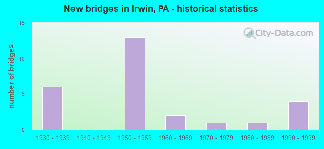
- New bridges - historical statistics
- 61930-1939
- 131950-1959
- 21960-1969
- 11970-1979
- 11980-1989
- 41990-1999

- Reconstructed bridges - Historical Statistics
- 11970-1979
- 11980-1989
- 41990-1999


- Bridge Condition - Deck
- 46.7%Good
- 26.7%Satisfactory
- 13.3%Fair
- 13.3%Poor

- Bridge Condition - Superstructure
- 26.7%Good
- 40.0%Satisfactory
- 26.7%Fair
- 6.7%Poor

- Bridge Condition - Substructure
- 20.0%Good
- 46.7%Satisfactory
- 20.0%Fair
- 6.7%Poor
- 6.7%Imminent failure

- Bridge Condition - Channel
- 41.7%Good
- 33.3%Satisfactory
- 16.7%Poor
- 8.3%Critical

- Bridge Condition - Culverts
- 33.3%Good
- 33.3%Satisfactory
- 33.3%Fair
Find on map >> Show street view
Structure Number: 37, Location: 2 MI. E. OF FOUNTAINDALE (Lat: 39.741956, Lng: -77.410892), Route carried "on" structure: State highway 16, Year Built: 1952, Status: Open, Structure Length: 1.13m (3.71ft), Average Daily Traffic: 6,232 (year 2022), Truck Traffic: 11%, Average Future Daily Traffic: 7,815 (year 2032), Design Load: HS 20, Features Intersected: MINEY BRANCH
Minimum Vertical Clearance: 30+ m (98+ ft), Kilometerpoint: 4.043, Lanes on structure: 2, Owner: State Highway Agency, Approaching Roadway Width: 9.8m (32.2ft), Skew: 3 degrees, Material/Design: Concrete, Design/Construction: Culvert, Number Of Spans In Main Unit: 1, Length of Maximum Span: 11.3m (37.1ft)
Condition: Channel: Satisfactory, Culverts: Satisfactory, Operating Rating: 69.9 metric tons, Method Used To Determine Operating Rating: Allowable Stress (AS), Inventory Rating: 46.3 metric tons, Method Used To Determine Inventory Rating: Allowable Stress (AS), Structural Evaluation: Equal to present minimum criteria, Waterway Adequacy: Superior to present desirable criteria, Approach Roadway Alignment: Equal to present desirable criteria, Length Of Structure Improvement: 1.70m (5.58ft), Designated Inspection Frequency: Every 24 months, Inspection Date: November 2020
Find on map >> Show street view
Structure Number: 3671, Location: 3145' N.E. OF SR 1016 (Lat: 40.748953, Lng: -80.285097), Route carried "on" structure: State highway , Year Built: 1967, Status: Open, Structure Length: 1.01m (3.31ft), Average Daily Traffic: 492 (year 2022), Truck Traffic: 4%, Average Future Daily Traffic: 813 (year 2032), Design Load: HS 20, Features Intersected: BR.BLOCK HOUSE RUN, Facility Carried by Structure: BLOCK HOUSE RUN RD
Minimum Vertical Clearance: 30+ m (98+ ft), Kilometerpoint: 0.737, Lanes on structure: 2, Owner: State Highway Agency, Approaching Roadway Width: 6.4m (21.0ft), Skew: 4 degrees, Material/Design: Concrete, Design/Construction: Slab, Number Of Spans In Main Unit: 1, Length of Maximum Span: 7.6m (24.9ft), Curb or Sidewalk Widths: Left: 0.2m (0.7ft), Right: 0.2m (0.7ft), Curb-To-Curb Width: 10.8m (35.4ft), Out-to-Out Width: 12.0m (39.4ft)
Condition: Deck: Good, Superstructure: Good, Substructure: Good, Channel: Satisfactory, Operating Rating: 59.0 metric tons, Method Used To Determine Operating Rating: Load Factor (LF), Inventory Rating: 35.4 metric tons, Method Used To Determine Inventory Rating: Load Factor (LF), Structural Evaluation: Better than present minimum criteria, Deck Geometry: Equal to present minimum criteria, Waterway Adequacy: Better than present minimum criteria, Approach Roadway Alignment: Better than present minimum criteria, Length Of Structure Improvement: 1.00m (3.28ft), Designated Inspection Frequency: Every 24 months, Inspection Date: August 2021, Bridge Improvement Cost: $4,000, Roadway Improvement Cost: $24,000, Total Project Cost: $52,000, Deck Structure Type: Concrete Cast-file-Place, Wearing Surface/Protective System: Wearing Surface: Bituminous
Find on map >> Show street view
Structure Number: 3592, Location: IRWIN VIADUCT (Lat: 40.326497, Lng: -79.711953), Route carried "on" structure: US 30, Year Built: 1939, Year Reconstructed: 1984, Status: Open, Structure Length: 15.97m (52.40ft), Average Daily Traffic: 26,983 (year 2022), Truck Traffic: 5%, Average Future Daily Traffic: 31,770 (year 2032), Design Load: HS 25 or greater, Features Intersected: TINKERS RN,CO RD,ABND RR
Minimum Vertical Clearance: 30+ m (98+ ft), Kilometerpoint: 6.964, Lanes on structure: 4, Lanes under structure: 2, Base Highway Network: Yes, Owner: State Highway Agency, Approaching Roadway Width: 14.0m (45.9ft), Material/Design: Steel continuous, Design/Construction: Stringer/Multi-beam, Number Of Spans In Main Unit: 8, Length of Maximum Span: 22.9m (75.1ft), Curb or Sidewalk Widths: Left: 0.2m (0.7ft), Right: 0.2m (0.7ft), Curb-To-Curb Width: 15.2m (49.9ft), Out-to-Out Width: 16.0m (52.5ft)
Condition: Deck: Satisfactory, Superstructure: Satisfactory, Substructure: Fair, Channel: Good, Inventory Rating: 62.6 metric tons, Method Used To Determine Inventory Rating: Load Factor (LF), Structural Evaluation: Somewhat better than minimum adequacy, Deck Geometry: High priority of corrective action, Underclear: High priority of corrective action, Waterway Adequacy: Superior to present desirable criteria, Approach Roadway Alignment: Equal to present desirable criteria, Length Of Structure Improvement: 16.90m (55.45ft), Designated Inspection Frequency: Every 24 months, Inspection Date: April 2021, Bridge Improvement Cost: $241,000, Roadway Improvement Cost: $710,000, Total Project Cost: $3,255,000, Deck Structure Type: Concrete Cast-file-Place, Wearing Surface/Protective System: Wearing Surface: Monolithic Concrete, Deck Protection: Epoxy Coated Reinforcing
Find on map >> Show street view
Structure Number: 35921, Location: IRWIN BOROUGH (Lat: 40.325494, Lng: -79.705122), Route carried "on" structure: US 30, Year Built: 1939, Status: Open, Structure Length: 0.88m (2.89ft), Average Daily Traffic: 26,983 (year 2022), Truck Traffic: 5%, Average Future Daily Traffic: 31,770 (year 2032), Design Load: H 20, Features Intersected: BRANCH OF BRUSH CREEK
Minimum Vertical Clearance: 30+ m (98+ ft), Kilometerpoint: 7.725, Lanes on structure: 4, Base Highway Network: Yes, Owner: State Highway Agency, Approaching Roadway Width: 18.9m (62.0ft), Skew: 4 degrees, Material/Design: Concrete, Design/Construction: Culvert, Number Of Spans In Main Unit: 1, Length of Maximum Span: 6.1m (20.0ft)
Condition: Channel: Poor, Culverts: Fair, Inventory Rating: 99.8 metric tons, Method Used To Determine Inventory Rating: Field evaluation and documented engineering judgment, Structural Evaluation: Somewhat better than minimum adequacy, Waterway Adequacy: Superior to present desirable criteria, Approach Roadway Alignment: Equal to present desirable criteria, Length Of Structure Improvement: 1.20m (3.94ft), Designated Inspection Frequency: Every 24 months, Inspection Date: April 2021
Find on map >> Show street view
Structure Number: 36356, Location: IRWIN BOROUGH (Lat: 40.334992, Lng: -79.712667), Route carried "on" structure: State highway 993, Year Built: 1992, Status: Open, Structure Length: 0.70m (2.30ft), Average Daily Traffic: 3,339 (year 2020), Truck Traffic: 9%, Average Future Daily Traffic: 5,366 (year 2032), Design Load: HS 25 or greater, Features Intersected: TINKERS RUN
Minimum Vertical Clearance: 30+ m (98+ ft), Kilometerpoint: 7.525, Lanes on structure: 2, Owner: State Highway Agency, Approaching Roadway Width: 9.8m (32.2ft), Skew: 1 degrees, Material/Design: Concrete, Design/Construction: Slab, Number Of Spans In Main Unit: 1, Length of Maximum Span: 6.7m (22.0ft), Curb or Sidewalk Widths: Left: 0.2m (0.7ft), Right: 0.2m (0.7ft), Curb-To-Curb Width: 12.1m (39.7ft), Out-to-Out Width: 13.2m (43.3ft)
Condition: Deck: Good, Superstructure: Good, Substructure: Good, Channel: Good, Operating Rating: 70.8 metric tons, Method Used To Determine Operating Rating: Load Factor (LF), Inventory Rating: 42.6 metric tons, Method Used To Determine Inventory Rating: Load Factor (LF), Structural Evaluation: Better than present minimum criteria, Deck Geometry: Somewhat better than minimum adequacy, Waterway Adequacy: Meets minimum limits, Approach Roadway Alignment: Equal to present desirable criteria, Length Of Structure Improvement: 1.30m (4.27ft), Designated Inspection Frequency: Every 48 months, Inspection Date: July 2021, Wearing Surface/Protective System: Wearing Surface: Monolithic Concrete, Deck Protection: Epoxy Coated Reinforcing
Find on map >> Show street view
Structure Number: 3671, Location: IRWIN BOROUGH (Lat: 40.334914, Lng: -79.709686), Route carried "on" structure: State highway , Year Built: 1993, Status: Open, Structure Length: 1.40m (4.59ft), Average Daily Traffic: 3,154 (year 2022), Truck Traffic: 8%, Average Future Daily Traffic: 3,533 (year 2032), Design Load: HS 25 or greater, Features Intersected: BRUSH CREEK, Facility Carried by Structure: SR 4025
Minimum Vertical Clearance: 30+ m (98+ ft), Kilometerpoint: 0.000, Lanes on structure: 2, Owner: State Highway Agency, Approaching Roadway Width: 9.8m (32.2ft), Material/Design: Prestressed concrete, Design/Construction: Box Beam or Girders - Multiple, Number Of Spans In Main Unit: 1, Length of Maximum Span: 14.0m (45.9ft), Curb or Sidewalk Widths: Left: 1.7m (5.6ft), Right: 0.2m (0.7ft), Curb-To-Curb Width: 9.8m (32.2ft), Out-to-Out Width: 12.3m (40.4ft)
Condition: Deck: Good, Superstructure: Good, Substructure: Satisfactory, Channel: Good, Operating Rating: 89.8 metric tons, Method Used To Determine Operating Rating: Load Factor (LF), Inventory Rating: 49.0 metric tons, Method Used To Determine Inventory Rating: Load Factor (LF), Structural Evaluation: Equal to present minimum criteria, Deck Geometry: Meets minimum limits, Waterway Adequacy: Superior to present desirable criteria, Approach Roadway Alignment: Equal to present desirable criteria, Length Of Structure Improvement: 2.20m (7.22ft), Designated Inspection Frequency: Every 24 months, Inspection Date: Febuary 2020, Bridge Improvement Cost: $72,000, Roadway Improvement Cost: $213,000, Total Project Cost: $975,000, Deck Structure Type: Concrete Cast-file-Place, Wearing Surface/Protective System: Wearing Surface: Monolithic Concrete, Deck Protection: Epoxy Coated Reinforcing
Find on map >> Show street view
Structure Number: 36819, Location: WESTMORELAND CITY (Lat: 40.330025, Lng: -79.687675), Route carried "on" structure: Other road 76, Year Built: 1952, Year Reconstructed: 1995, Status: Open, Structure Length: 30.51m (100.10ft), Average Daily Traffic: 44,987 (year 2001), Truck Traffic: 18%, Average Future Daily Traffic: 46,918 (year 2030), Design Load: HS 25 or greater, Features Intersected: SR 0993, BRUSH CK. & RR
Minimum Vertical Clearance: 30+ m (98+ ft), Kilometerpoint: 0.000, Lanes on structure: 2, Lanes under structure: 2, Base Highway Network: Yes, Toll: On toll road, Owner: State Toll Authority, Approaching Roadway Width: 12.2m (40.0ft), Skew: 32 degrees, Material/Design: Steel, Design/Construction: Girder and Floorbeam System, Number Of Spans In Main Unit: 10, Number Of Approach Spans: 1, Length of Maximum Span: 36.6m (120.1ft), Curb or Sidewalk Widths: Left: 0.2m (0.7ft), Right: 0.2m (0.7ft), Curb-To-Curb Width: 12.2m (40.0ft), Out-to-Out Width: 26.1m (85.6ft)
Condition: Deck: Satisfactory, Superstructure: Satisfactory, Substructure: Fair, Channel: Poor, Operating Rating: 54.4 metric tons, Method Used To Determine Operating Rating: Load Factor (LF), Inventory Rating: 32.7 metric tons, Method Used To Determine Inventory Rating: Load Factor (LF), Structural Evaluation: Somewhat better than minimum adequacy, Deck Geometry: Better than present minimum criteria, Underclear: Superior to present desirable criteria, Waterway Adequacy: Superior to present desirable criteria, Approach Roadway Alignment: Equal to present desirable criteria, Length Of Structure Improvement: 31.00m (101.71ft), Designated Inspection Frequency: Every 24 months, Critical Feature Inspection Frequency: Every 24 months, Inspection Date: November 2019, Critical Feature Inspection Date: November 2019, Bridge Improvement Cost: $743,000, Roadway Improvement Cost: $2,189,000, Total Project Cost: $10,034,000, Deck Structure Type: Concrete Cast-file-Place, Wearing Surface/Protective System: Wearing Surface: Latex Concrete, Deck Protection: Epoxy Coated Reinforcing
Find on map >> Show street view
Structure Number: 3682, Location: WESTMORELAND CITY (Lat: 40.323333, Lng: -79.685000), Route carried "on" structure: Interstate 76, Year Built: 1952, Status: Open, Structure Length: 1.34m (4.40ft), Average Daily Traffic: 46,261 (year 2004), Truck Traffic: 16%, Average Future Daily Traffic: 48,038 (year 2030), Design Load: HS 20, Features Intersected: SR 4017; Brush Hill Rd
Minimum Vertical Clearance: 30+ m (98+ ft), Kilometerpoint: 0.000, Lanes on structure: 4, Lanes under structure: 2, Base Highway Network: Yes, Toll: On toll road, Owner: State Toll Authority, Approaching Roadway Width: 23.8m (78.1ft), Skew: 30 degrees, Material/Design: Steel, Design/Construction: Stringer/Multi-beam, Number Of Spans In Main Unit: 1, Length of Maximum Span: 12.2m (40.0ft), Curb or Sidewalk Widths: Left: 0.2m (0.7ft), Right: 0.2m (0.7ft), Curb-To-Curb Width: 20.8m (68.2ft), Out-to-Out Width: 22.4m (73.5ft)
Condition: Deck: Fair, Superstructure: Fair, Substructure: Satisfactory, Operating Rating: 59.9 metric tons, Method Used To Determine Operating Rating: Load Factor (LF), Inventory Rating: 36.3 metric tons, Method Used To Determine Inventory Rating: Load Factor (LF), Structural Evaluation: Somewhat better than minimum adequacy, Deck Geometry: Equal to present minimum criteria, Underclear: Somewhat better than minimum adequacy, Approach Roadway Alignment: Equal to present desirable criteria, Length Of Structure Improvement: 1.90m (6.23ft), Designated Inspection Frequency: Every 24 months, Inspection Date: July 2020, Bridge Improvement Cost: $32,000, Roadway Improvement Cost: $95,000, Total Project Cost: $437,000, Deck Structure Type: Concrete Cast-file-Place, Wearing Surface/Protective System: Wearing Surface: Bituminous
Find on map >> Show street view
Structure Number: 36821, Location: WEST OF IRWIN INTERCHANGE (Lat: 40.318333, Lng: -79.675000), Route carried "on" structure: Interstate 76, Year Built: 1952, Year Reconstructed: 1995, Status: Open, Structure Length: 1.77m (5.81ft), Average Daily Traffic: 46,261 (year 2004), Truck Traffic: 16%, Average Future Daily Traffic: 48,038 (year 2030), Design Load: HS 20, Features Intersected: T-755, Pennsylvania Ave.
Minimum Vertical Clearance: 30+ m (98+ ft), Kilometerpoint: 0.000, Lanes on structure: 4, Lanes under structure: 2, Base Highway Network: Yes, Toll: On toll road, Owner: State Toll Authority, Approaching Roadway Width: 23.8m (78.1ft), Skew: 32 degrees, Material/Design: Steel, Design/Construction: Stringer/Multi-beam, Number Of Spans In Main Unit: 1, Length of Maximum Span: 16.2m (53.1ft), Curb or Sidewalk Widths: Left: 0.2m (0.7ft), Right: 0.2m (0.7ft), Curb-To-Curb Width: 24.4m (80.1ft), Out-to-Out Width: 26.1m (85.6ft)
Condition: Deck: Satisfactory, Superstructure: Satisfactory, Substructure: Satisfactory, Inventory Rating: 65.3 metric tons, Method Used To Determine Inventory Rating: Load Factor (LF), Structural Evaluation: Equal to present minimum criteria, Deck Geometry: Superior to present desirable criteria, Underclear: Meets minimum limits, Approach Roadway Alignment: Equal to present desirable criteria, Length Of Structure Improvement: 2.50m (8.20ft), Designated Inspection Frequency: Every 48 months, Inspection Date: July 2018, Bridge Improvement Cost: $42,000, Roadway Improvement Cost: $123,000, Total Project Cost: $564,000, Deck Structure Type: Concrete Cast-file-Place, Wearing Surface/Protective System: Wearing Surface: Latex Concrete, Deck Protection: Epoxy Coated Reinforcing
Find on map >> Show street view
Structure Number: 36822, Location: IRWIN INTERCHANGE (Lat: 40.315025, Lng: -79.678339), Route carried "on" structure: Ramp State highway , Year Built: 1939, Status: Open, Structure Length: 2.44m (8.01ft), Average Daily Traffic: 224 (year 2010), Truck Traffic: 23%, Average Future Daily Traffic: 286 (year 2030), Design Load: HS 20, Features Intersected: SR 0030, Facility Carried by Structure: PA TPK (RAMP 3&3A)
Minimum Vertical Clearance: 30+ m (98+ ft), Kilometerpoint: 0.000, Lanes on structure: 2, Lanes under structure: 4, Base Highway Network: Yes, Toll: On toll road, Owner: State Toll Authority, Approaching Roadway Width: 18.3m (60.0ft), Skew: 30 degrees, Material/Design: Concrete, Design/Construction: Frame, Number Of Spans In Main Unit: 1, Length of Maximum Span: 21.9m (71.9ft), Curb or Sidewalk Widths: Left: 0.2m (0.7ft), Right: 0.2m (0.7ft), Curb-To-Curb Width: 16.5m (54.1ft), Out-to-Out Width: 18.9m (62.0ft)
Condition: Deck: Satisfactory, Superstructure: Fair, Substructure: Satisfactory, Operating Rating: 51.7 metric tons, Method Used To Determine Operating Rating: Load Factor (LF), Inventory Rating: 30.8 metric tons, Method Used To Determine Inventory Rating: Load Factor (LF), Structural Evaluation: Somewhat better than minimum adequacy, Deck Geometry: Superior to present desirable criteria, Underclear: High priority of corrective action, Approach Roadway Alignment: Equal to present desirable criteria, Length Of Structure Improvement: 3.20m (10.50ft), Designated Inspection Frequency: Every 24 months, Inspection Date: July 2020, Bridge Improvement Cost: $45,000, Roadway Improvement Cost: $133,000, Total Project Cost: $610,000, Wearing Surface/Protective System: Wearing Surface: Bituminous
Find on map >> Show street view
Structure Number: 36823, Location: IRWIN INTERCHANGE (Lat: 40.318333, Lng: -79.673333), Route carried "on" structure: Interstate 76, Year Built: 1952, Year Reconstructed: 1995, Status: Open, Structure Length: 3.57m (11.71ft), Average Daily Traffic: 34,735 (year 2004), Truck Traffic: 20%, Average Future Daily Traffic: 40,738 (year 2030), Design Load: HS 20, Features Intersected: SR 0030
Minimum Vertical Clearance: 30+ m (98+ ft), Kilometerpoint: 0.000, Lanes on structure: 4, Lanes under structure: 10, Base Highway Network: Yes, Toll: On toll road, Owner: State Toll Authority, Approaching Roadway Width: 21.3m (69.9ft), Skew: 34 degrees, Material/Design: Steel, Design/Construction: Stringer/Multi-beam, Number Of Spans In Main Unit: 1, Length of Maximum Span: 33.5m (109.9ft), Curb or Sidewalk Widths: Left: 0.2m (0.7ft), Right: 0.2m (0.7ft), Curb-To-Curb Width: 24.4m (80.1ft), Out-to-Out Width: 26.1m (85.6ft)
Condition: Deck: Good, Superstructure: Satisfactory, Substructure: Satisfactory, Operating Rating: 66.2 metric tons, Method Used To Determine Operating Rating: Load Factor (LF), Inventory Rating: 39.9 metric tons, Method Used To Determine Inventory Rating: Load Factor (LF), Structural Evaluation: Equal to present minimum criteria, Deck Geometry: Superior to present desirable criteria, Underclear: Equal to present minimum criteria, Approach Roadway Alignment: Equal to present desirable criteria, Length Of Structure Improvement: 4.60m (15.09ft), Designated Inspection Frequency: Every 24 months, Inspection Date: July 2020, Bridge Improvement Cost: $88,000, Roadway Improvement Cost: $258,000, Total Project Cost: $1,183,000, Deck Structure Type: Concrete Cast-file-Place, Wearing Surface/Protective System: Wearing Surface: Latex Concrete, Deck Protection: Epoxy Coated Reinforcing
Find on map >> Show street view
Structure Number: 36824, Location: IRWIN INTERCHANGE (Lat: 40.316667, Lng: -79.673333), Route carried "on" structure: Ramp Other road , Year Built: 1952, Year Reconstructed: 1988, Status: Open, Structure Length: 3.41m (11.19ft), Average Daily Traffic: 10,020 (year 2008), Truck Traffic: 9%, Average Future Daily Traffic: 10,600 (year 2030), Design Load: HS 20, Features Intersected: PA TPK (I-76), Facility Carried by Structure: PA TPK RAMPS B&C
Minimum Vertical Clearance: 30+ m (98+ ft), Kilometerpoint: 0.000, Lanes on structure: 2, Lanes under structure: 4, Base Highway Network: Yes, Toll: On toll road, Owner: State Toll Authority, Approaching Roadway Width: 15.8m (51.8ft), Skew: 31 degrees, Material/Design: Steel, Design/Construction: Girder and Floorbeam System, Number Of Spans In Main Unit: 1, Length of Maximum Span: 32.9m (107.9ft), Curb or Sidewalk Widths: Left: 0.2m (0.7ft), Right: 0.2m (0.7ft), Curb-To-Curb Width: 10.4m (34.1ft), Out-to-Out Width: 12.9m (42.3ft)
Condition: Deck: Good, Superstructure: Satisfactory, Substructure: Fair, Operating Rating: 64.4 metric tons, Method Used To Determine Operating Rating: Load Factor (LF), Inventory Rating: 39.0 metric tons, Method Used To Determine Inventory Rating: Load Factor (LF), Structural Evaluation: Somewhat better than minimum adequacy, Deck Geometry: Better than present minimum criteria, Underclear: High priority of corrective action, Approach Roadway Alignment: Equal to present desirable criteria, Length Of Structure Improvement: 4.60m (15.09ft), Designated Inspection Frequency: Every 24 months, Critical Feature Inspection Frequency: Every 24 months, Inspection Date: July 2020, Critical Feature Inspection Date: July 2020, Deck Structure Type: Concrete Cast-file-Place, Wearing Surface/Protective System: Wearing Surface: Other
Find on map >> Show street view
Structure Number: 36872, Location: AT MAIN ST INTERSECT (Lat: 40.328033, Lng: -79.712236), Route carried "on" structure: County highway , Year Built: 1979, Status: Open, Structure Length: 1.55m (5.09ft), Average Daily Traffic: 6,600 (year 2012), Truck Traffic: 15%, Average Future Daily Traffic: 8,500 (year 2032), Design Load: HS 20, Features Intersected: TINKER RUN, Facility Carried by Structure: CENTER HIGHWAY
Minimum Vertical Clearance: 30+ m (98+ ft), Kilometerpoint: 0.000, Lanes on structure: 2, Base Highway Network: Yes, Owner: County Highway Agency, Approaching Roadway Width: 11.0m (36.1ft), Skew: 1 degrees, Material/Design: Prestressed concrete, Design/Construction: Box Beam or Girders - Multiple, Number Of Spans In Main Unit: 1, Length of Maximum Span: 15.2m (49.9ft), Curb or Sidewalk Widths: Left: 1.7m (5.6ft), Right: 0.2m (0.7ft), Curb-To-Curb Width: 10.1m (33.1ft), Out-to-Out Width: 12.8m (42.0ft)
Condition: Deck: Fair, Superstructure: Fair, Substructure: Satisfactory, Channel: Satisfactory, Operating Rating: 44.5 metric tons, Method Used To Determine Operating Rating: Load Factor (LF), Inventory Rating: 13.6 metric tons, Method Used To Determine Inventory Rating: Load Factor (LF), Structural Evaluation: High priority of corrective action, Deck Geometry: Meets minimum limits, Waterway Adequacy: Superior to present desirable criteria, Approach Roadway Alignment: Equal to present desirable criteria, Length Of Structure Improvement: 1.60m (5.25ft), Designated Inspection Frequency: Every 24 months, Inspection Date: June 2020, Deck Structure Type: Other, Wearing Surface/Protective System: Wearing Surface: Bituminous
Find on map >> Show street view
Structure Number: 36873, Location: 250' NORTH OF SR 993 (Lat: 40.331600, Lng: -79.693600), Route carried "on" structure: City street , Year Built: 1996, Status: Open, Structure Length: 7.04m (23.10ft), Average Daily Traffic: 920 (year 2012), Truck Traffic: 5%, Average Future Daily Traffic: 1,180 (year 2032), Design Load: HS 25 or greater, Features Intersected: NORFOLK SOUTHERN, Facility Carried by Structure: BRIDGE STREET
Minimum Vertical Clearance: 30+ m (98+ ft), Kilometerpoint: 0.000, Lanes on structure: 2, Owner: Railroad, Maintenance Responsibility: Town or Township Highway Agency, Approaching Roadway Width: 7.9m (25.9ft), Material/Design: Steel continuous, Design/Construction: Stringer/Multi-beam, Number Of Spans In Main Unit: 2, Length of Maximum Span: 34.1m (111.9ft), Curb or Sidewalk Widths: Left: 1.5m (4.9ft), Right: 0.2m (0.7ft), Curb-To-Curb Width: 7.9m (25.9ft), Out-to-Out Width: 10.3m (33.8ft)
Condition: Deck: Good, Superstructure: Good, Substructure: Good, Channel: Good, Operating Rating: 88.9 metric tons, Method Used To Determine Operating Rating: Load Factor (LF), Inventory Rating: 52.6 metric tons, Method Used To Determine Inventory Rating: Load Factor (LF), Structural Evaluation: Better than present minimum criteria, Deck Geometry: Somewhat better than minimum adequacy, Underclear: High priority of corrective action, Waterway Adequacy: Superior to present desirable criteria, Approach Roadway Alignment: Somewhat better than minimum adequacy, Length Of Structure Improvement: 8.60m (28.22ft), Designated Inspection Frequency: Every 24 months, Inspection Date: November 2020, Bridge Improvement Cost: $47,000, Roadway Improvement Cost: $137,000, Total Project Cost: $630,000, Deck Structure Type: Corrugated Steel, Wearing Surface/Protective System: Wearing Surface: Monolithic Concrete, Deck Protection: Epoxy Coated Reinforcing
Find on map >> Show street view
Structure Number: 36999, Location: FIRST STREET BRIDGE (Lat: 40.333786, Lng: -79.712403), Route carried "on" structure: Business City street FR0T, Year Built: 1950, Status: Closed, Structure Length: 0.98m (3.22ft), Average Future Daily Traffic: 500 (year 2024), Features Intersected: TINKERS RUN, Facility Carried by Structure: FIRST STREET
Minimum Vertical Clearance: 30+ m (98+ ft), Kilometerpoint: 0.000, Lanes on structure: 2, Owner: City or Municipal Highway Agency, Approaching Roadway Width: 5.5m (18.0ft), Material/Design: Steel, Design/Construction: Stringer/Multi-beam, Number Of Spans In Main Unit: 1, Length of Maximum Span: 9.1m (29.9ft), Curb or Sidewalk Widths: Left: 0.0m, Right: 1.5m (4.9ft), Curb-To-Curb Width: 5.8m (19.0ft), Out-to-Out Width: 7.6m (24.9ft)
Condition: Deck: Poor, Superstructure: Fair, Substructure: Imminent failure, Channel: Critical, Deck Geometry: Meets minimum limits, Waterway Adequacy: Equal to present minimum criteria, Approach Roadway Alignment: Better than present minimum criteria, Bridge Posting: Required (Relationship of Operating Rating to Maximum Legal Load: > 39.9% below), Length Of Structure Improvement: 1.00m (3.28ft), Designated Inspection Frequency: Every 24 months, Inspection Date: November 2020, Bridge Improvement Cost: $4,000, Roadway Improvement Cost: $14,000, Total Project Cost: $51,000, Deck Structure Type: Concrete Cast-file-Place, Wearing Surface/Protective System: Wearing Surface: Monolithic Concrete
Find on map >> Show street view
Structure Number: 37, Location: CARUTHERS LANE (Lat: 40.322061, Lng: -79.698972), Route carried "on" structure: Business City street C0L0, Year Built: 1999, Status: Open, Structure Length: 0.70m (2.30ft), Average Daily Traffic: 3,500 (year 2004), Truck Traffic: 3%, Average Future Daily Traffic: 3,000 (year 2000), Design Load: HL 93, Features Intersected: EAST BR OF TINKERS RUN, Facility Carried by Structure: CARUTHERS LANE
Minimum Vertical Clearance: 30+ m (98+ ft), Kilometerpoint: 0.000, Lanes on structure: 2, Owner: City or Municipal Highway Agency, Approaching Roadway Width: 6.7m (22.0ft), Material/Design: Concrete, Design/Construction: Culvert, Number Of Spans In Main Unit: 1, Length of Maximum Span: 6.1m (20.0ft), Curb or Sidewalk Widths: Left: 1.7m (5.6ft), Right: 0.0m, Curb-To-Curb Width: 10.4m (34.1ft), Out-to-Out Width: 10.4m (34.1ft)
Condition: Channel: Good, Culverts: Good, Operating Rating: 95.3 metric tons, Method Used To Determine Operating Rating: Load Factor (LF), Inventory Rating: 57.2 metric tons, Method Used To Determine Inventory Rating: Load Factor (LF), Structural Evaluation: Better than present minimum criteria, Deck Geometry: Somewhat better than minimum adequacy, Waterway Adequacy: Better than present minimum criteria, Approach Roadway Alignment: Equal to present desirable criteria, Length Of Structure Improvement: 0.60m (1.97ft), Designated Inspection Frequency: Every 24 months, Inspection Date: November 2020, Bridge Improvement Cost: $11,000, Roadway Improvement Cost: $40,000, Total Project Cost: $150,000, Deck Structure Type: Concrete Cast-file-Place, Wearing Surface/Protective System: Wearing Surface: Bituminous, Membrane: Preformed Fabric, Deck Protection: Epoxy Coated Reinforcing
Find on map >> Show street view
Structure Number: 37002, Location: FAIRWOOD MANOR BRIDGE (Lat: 40.324575, Lng: -79.703125), Route carried "on" structure: Business City street FWMR, Year Built: 1965, Year Reconstructed: 2003, Status: Posted for load, Structure Length: 0.73m (2.40ft), Average Daily Traffic: 2,000 (year 2004), Truck Traffic: 5%, Average Future Daily Traffic: 2,000 (year 2024), Design Load: HS 20, Features Intersected: TINKERS RUN, Facility Carried by Structure: FAIRWOOD MANOR DR
Minimum Vertical Clearance: 30+ m (98+ ft), Kilometerpoint: 0.000, Lanes on structure: 2, Owner: Town or Township Highway Agency, Approaching Roadway Width: 9.1m (29.9ft), Material/Design: Steel, Design/Construction: Stringer/Multi-beam, Number Of Spans In Main Unit: 1, Length of Maximum Span: 6.4m (21.0ft), Curb-To-Curb Width: 8.9m (29.2ft), Out-to-Out Width: 9.6m (31.5ft)
Condition: Deck: Poor, Superstructure: Poor, Substructure: Poor, Channel: Satisfactory, Operating Rating: 25.4 metric tons, Method Used To Determine Operating Rating: Load Factor (LF), Inventory Rating: 15.4 metric tons, Method Used To Determine Inventory Rating: Load Factor (LF), Structural Evaluation: Meets minimum limits, Deck Geometry: Somewhat better than minimum adequacy, Waterway Adequacy: Better than present minimum criteria, Approach Roadway Alignment: Equal to present minimum criteria, Bridge Posting: Required (Relationship of Operating Rating to Maximum Legal Load: 30.0 - 39.9% below), Length Of Structure Improvement: 0.80m (2.62ft), Designated Inspection Frequency: Every 24 months, Other Special Inspection Frequency: Every 6 months, Inspection Date: November 2020, Other Special Inspection Date: May 2021, Bridge Improvement Cost: $13,000, Roadway Improvement Cost: $38,000, Total Project Cost: $176,000, Deck Structure Type: Concrete Cast-file-Place, Wearing Surface/Protective System: Wearing Surface: Bituminous
Find on map >> Show street view
Structure Number: 45832, Location: 275' S OF WASHINGTON AVE (Lat: 40.333386, Lng: -79.704197), Route carried "on" structure: City street , Year Built: 1989, Status: Open, Structure Length: 3.35m (10.99ft), Average Daily Traffic: 200 (year 2012), Truck Traffic: 5%, Average Future Daily Traffic: 230 (year 2032), Design Load: HS 25 or greater, Features Intersected: NORFOLK SOUTHERN RR, Facility Carried by Structure: MOORE AVENUE
Minimum Vertical Clearance: 30+ m (98+ ft), Kilometerpoint: 0.000, Lanes on structure: 2, Owner: Town or Township Highway Agency, Approaching Roadway Width: 7.3m (24.0ft), Material/Design: Steel, Design/Construction: Stringer/Multi-beam, Number Of Spans In Main Unit: 1, Length of Maximum Span: 32.0m (105.0ft), Curb or Sidewalk Widths: Left: 0.2m (0.7ft), Right: 0.2m (0.7ft), Curb-To-Curb Width: 7.3m (24.0ft), Out-to-Out Width: 8.4m (27.6ft)
Condition: Deck: Good, Superstructure: Satisfactory, Substructure: Satisfactory, Inventory Rating: 65.3 metric tons, Method Used To Determine Inventory Rating: Load Factor (LF), Structural Evaluation: Equal to present minimum criteria, Deck Geometry: Somewhat better than minimum adequacy, Underclear: High priority of corrective action, Approach Roadway Alignment: Equal to present desirable criteria, Designated Inspection Frequency: Every 24 months, Critical Feature Inspection Frequency: Every 24 months, Inspection Date: June 2020, Critical Feature Inspection Date: June 2020, Deck Structure Type: Concrete Cast-file-Place, Wearing Surface/Protective System: Wearing Surface: Monolithic Concrete, Deck Protection: Epoxy Coated Reinforcing
Find on map >> Show street view
Structure Number: 3592, Location: IRWIN VIADUCT (Lat: 40.326497, Lng: -79.711953), Route carried "under" structure: County highway , Year Built: 1939, Structure Length: 0. m, Average Daily Traffic: 100 (year 2005), Truck Traffic: 5%, Features Intersected: TINKERS RN,CO RD,ABND RR, Facility Carried by Structure: SR 0030
Minimum Vertical Clearance: 3.89m (12.76ft), Kilometerpoint: 0.000, Lanes on structure: 4, Lanes under structure: 2, Material/Design: Steel continuous, Design/Construction: Stringer/Multi-beam, Length of Maximum Span: 22.9m (75.1ft)
Find on map >> Show street view
Structure Number: 36819, Location: WESTMORELAND CITY (Lat: 40.330025, Lng: -79.687675), Route carried "under" structure: State highway 993, Year Built: 1952, Structure Length: 0. m, Average Daily Traffic: 151 (year 2020), Truck Traffic: 16%, Features Intersected: SR 0993, BRUSH CK. & RR, Facility Carried by Structure: PA TPK (I-76)
Minimum Vertical Clearance: 8.99m (29.49ft), Kilometerpoint: 10.934, Lanes on structure: 2, Lanes under structure: 2, Material/Design: Steel, Design/Construction: Girder and Floorbeam System, Length of Maximum Span: 36.6m (120.1ft)
Find on map >> Show street view
Structure Number: 3682, Location: WESTMORELAND CITY (Lat: 40.323333, Lng: -79.685000), Route carried "under" structure: State highway , Year Built: 1952, Structure Length: 0. m, Average Daily Traffic: 6,524 (year 2022), Truck Traffic: 4%, Features Intersected: SR 4017; Brush Hill Rd, Facility Carried by Structure: PA TPK (I-76)
Minimum Vertical Clearance: 8.86m (29.07ft), Kilometerpoint: 0.000, Lanes on structure: 4, Lanes under structure: 2, Material/Design: Steel, Design/Construction: Stringer/Multi-beam, Length of Maximum Span: 12.2m (40.0ft)
Find on map >> Show street view
Structure Number: 36821, Location: WEST OF IRWIN INTERCHANGE (Lat: 40.318333, Lng: -79.675000), Route carried "under" structure: City street , Year Built: 1952, Structure Length: 0. m, Average Daily Traffic: 200 (year 1992), Features Intersected: T-755, Pennsylvania Ave., Facility Carried by Structure: PA TPK (I-76)
Minimum Vertical Clearance: 5.32m (17.45ft), Kilometerpoint: 0.000, Lanes on structure: 4, Lanes under structure: 2, Material/Design: Steel, Design/Construction: Stringer/Multi-beam, Length of Maximum Span: 16.2m (53.1ft)
Find on map >> Show street view
Structure Number: 36822, Location: IRWIN INTERCHANGE (Lat: 40.315025, Lng: -79.678339), Route carried "under" structure: US 30, Year Built: 1939, Structure Length: 0. m, Average Daily Traffic: 14,057 (year 2021), Truck Traffic: 5%, Features Intersected: SR 0030, Facility Carried by Structure: PA TPK (RAMP 3&3A)
Minimum Vertical Clearance: 4.46m (14.63ft), Kilometerpoint: 9.968, Lanes on structure: 2, Lanes under structure: 2, Material/Design: Concrete, Design/Construction: Frame, Length of Maximum Span: 21.9m (71.9ft)
Find on map >> Show street view
Structure Number: 36822, Location: IRWIN INTERCHANGE (Lat: 40.315025, Lng: -79.678339), Route carried "under" structure: US 30, Year Built: 1939, Structure Length: 0. m, Average Daily Traffic: 13,292 (year 2021), Truck Traffic: 5%, Features Intersected: SR 0030, Facility Carried by Structure: PA TPK (RAMP 3&3A)
Minimum Vertical Clearance: 4.57m (14.99ft), Kilometerpoint: 9.954, Lanes on structure: 2, Lanes under structure: 2, Material/Design: Concrete, Design/Construction: Frame, Length of Maximum Span: 21.9m (71.9ft)
Find on map >> Show street view
Structure Number: 36823, Location: IRWIN INTERCHANGE (Lat: 40.318333, Lng: -79.673333), Route carried "under" structure: US 30, Year Built: 1952, Structure Length: 0. m, Average Daily Traffic: 14,057 (year 2021), Truck Traffic: 5%, Features Intersected: SR 0030, Facility Carried by Structure: PA TPK (I-76)
Minimum Vertical Clearance: 6.13m (20.11ft), Kilometerpoint: 10.491, Lanes on structure: 4, Lanes under structure: 5, Material/Design: Steel, Design/Construction: Stringer/Multi-beam, Length of Maximum Span: 33.5m (109.9ft)
Find on map >> Show street view
Structure Number: 36823, Location: IRWIN INTERCHANGE (Lat: 40.318333, Lng: -79.673333), Route carried "under" structure: US 30, Year Built: 1952, Structure Length: 0. m, Average Daily Traffic: 13,292 (year 2021), Truck Traffic: 5%, Features Intersected: SR 0030, Facility Carried by Structure: PA TPK (I-76)
Minimum Vertical Clearance: 6.13m (20.11ft), Kilometerpoint: 10.472, Lanes on structure: 4, Lanes under structure: 5, Material/Design: Steel, Design/Construction: Stringer/Multi-beam, Length of Maximum Span: 33.5m (109.9ft)
Find on map >> Show street view
Structure Number: 36824, Location: IRWIN INTERCHANGE (Lat: 40.316667, Lng: -79.673333), Route carried "under" structure: Interstate 76, Year Built: 1952, Structure Length: 0. m, Average Daily Traffic: 44,987 (year 2001), Truck Traffic: 18%, Features Intersected: PA TPK (I-76), Facility Carried by Structure: PA TPK RAMPS B&C
Minimum Vertical Clearance: 4.46m (14.63ft), Kilometerpoint: 0.000, Lanes on structure: 2, Lanes under structure: 4, Toll: On toll road, Material/Design: Steel, Design/Construction: Girder and Floorbeam System, Length of Maximum Span: 32.9m (107.9ft)