Bridge Statistics for Ironwood, Michigan (MI)
Condition, Traffic, Stress, Structural Evaluation, Project Costs
- National Bridge Inventory (NBI) Statistics
- 12Number of bridges
- 66ft / 19.8mTotal length
- $1,237,000Total costs
- 19,961Total average daily traffic
- 1,060Total average daily truck traffic
- 29,107Total future (year 2006) average daily traffic
- National Bridge Inventory (NBI) Registered Bridges for Ironwood
- No street view available for this location
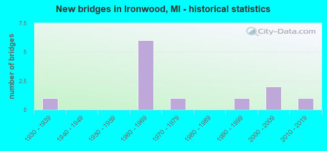
- New bridges - historical statistics
- 11930-1939
- 61960-1969
- 11970-1979
- 11990-1999
- 22000-2009
- 12010-2019

- Reconstructed bridges - Historical Statistics
- 21980-1989
- 01990-1999
- 12000-2009


- Bridge Condition - Deck
- 50.0%Good
- 25.0%Satisfactory
- 25.0%Fair

- Bridge Condition - Superstructure
- 37.5%Good
- 62.5%Satisfactory

- Bridge Condition - Substructure
- 25.0%Very good
- 37.5%Good
- 25.0%Satisfactory
- 12.5%Fair

- Bridge Condition - Channel
- 8.3%Very good
- 33.3%Good
- 50.0%Satisfactory
- 8.3%Fair

- Bridge Condition - Culverts
- 25.0%Good
- 25.0%Fair
- 50.0%Poor
Find on map >> Show street view
Structure Number: 295, Location: SALEM TWP SEC 34 (Lat: 42.688456, Lng: -85.822331), Route carried "on" structure: County highway , Year Built: 1979, Status: Open, Structure Length: 0.67m (2.20ft), Average Daily Traffic: 185 (year 2002), Truck Traffic: 7%, Average Future Daily Traffic: 370 (year 2022), Design Load: H 20, Features Intersected: PIGEON CREEK, Facility Carried by Structure: 137TH AVENUE
Minimum Vertical Clearance: 30.48m (100.00ft), Kilometerpoint: 1.423, Lanes on structure: 2, Owner: County Highway Agency, Approaching Roadway Width: 9.1m (29.9ft), Skew: 3 degrees, Material/Design: Steel, Design/Construction: Culvert, Number Of Spans In Main Unit: 2, Length of Maximum Span: 2.7m (8.9ft)
Condition: Channel: Satisfactory, Culverts: Good, Operating Rating: 97.2 metric tons, Method Used To Determine Operating Rating: Load Factor (LF) rating reported by rating factor (RF) method using MS18 loading, Inventory Rating: 86.5 metric tons, Method Used To Determine Inventory Rating: Load Factor (LF) rating reported by rating factor (RF) method using MS18 loading, Structural Evaluation: Better than present minimum criteria, Waterway Adequacy: Meets minimum limits, Approach Roadway Alignment: Equal to present desirable criteria, Designated Inspection Frequency: Every 24 months, Inspection Date: May 2021
Find on map >> Show street view
Structure Number: 2943, Location: IN IRONWOOD (Lat: 46.449947, Lng: -90.178467), Route carried "on" structure: Business US 2, Year Built: 1964, Year Reconstructed: 2006, Status: Open, Structure Length: 1.58m (5.18ft), Average Daily Traffic: 7,161 (year 2007), Truck Traffic: 7%, Average Future Daily Traffic: 7,510 (year 2018), Design Load: HS 20, Features Intersected: MONTREAL RIVER
Minimum Vertical Clearance: 30.48m (100.00ft), Kilometerpoint: 0.011, Lanes on structure: 2, Base Highway Network: Yes (Inventory Route: 148, Subroute: 10), Owner: State Highway Agency, Approaching Roadway Width: 14.6m (47.9ft), Skew: 3 degrees, Material/Design: Steel, Design/Construction: Stringer/Multi-beam, Number Of Spans In Main Unit: 1, Length of Maximum Span: 14.9m (48.9ft), Curb or Sidewalk Widths: Left: 2.4m (7.9ft), Right: 3.0m (9.8ft), Curb-To-Curb Width: 14.6m (47.9ft), Out-to-Out Width: 20.8m (68.2ft)
Condition: Deck: Satisfactory, Superstructure: Good, Substructure: Good, Channel: Satisfactory, Operating Rating: 77.4 metric tons, Method Used To Determine Operating Rating: Load Factor (LF) rating reported by rating factor (RF) method using MS18 loading, Inventory Rating: 46.3 metric tons, Method Used To Determine Inventory Rating: Load Factor (LF) rating reported by rating factor (RF) method using MS18 loading, Structural Evaluation: Better than present minimum criteria, Deck Geometry: Superior to present desirable criteria, Waterway Adequacy: Better than present minimum criteria, Approach Roadway Alignment: Better than present minimum criteria, Designated Inspection Frequency: Every 24 months, Inspection Date: August 2021, Deck Structure Type: Concrete Cast-file-Place, Wearing Surface/Protective System: Wearing Surface: Latex Concrete
Find on map >> Show street view
Structure Number: 2944, Location: IN IRONWOOD (Lat: 46.465578, Lng: -90.192200), Route carried "on" structure: US 2, Year Built: 1961, Year Reconstructed: 1986, Status: Open, Structure Length: 3.84m (12.60ft), Average Daily Traffic: 2,738 (year 2007), Truck Traffic: 11%, Average Future Daily Traffic: 6,700 (year 2018), Design Load: HS 20, Features Intersected: MONTREAL RIVER
Minimum Vertical Clearance: 30.48m (100.00ft), Kilometerpoint: 0.016, Lanes on structure: 2, Base Highway Network: Yes (Inventory Route: 327, Subroute: 65), Owner: State Highway Agency, Approaching Roadway Width: 12.2m (40.0ft), Skew: 3 degrees, Material/Design: Steel continuous, Design/Construction: Stringer/Multi-beam, Number Of Spans In Main Unit: 3, Length of Maximum Span: 15.2m (49.9ft), Curb-To-Curb Width: 12.2m (40.0ft), Out-to-Out Width: 13.1m (43.0ft)
Condition: Deck: Good, Superstructure: Satisfactory, Substructure: Satisfactory, Channel: Satisfactory, Operating Rating: 59.3 metric tons, Method Used To Determine Operating Rating: Load Factor (LF) rating reported by rating factor (RF) method using MS18 loading, Inventory Rating: 30.8 metric tons, Method Used To Determine Inventory Rating: Load Factor (LF) rating reported by rating factor (RF) method using MS18 loading, Structural Evaluation: Equal to present minimum criteria, Deck Geometry: Better than present minimum criteria, Waterway Adequacy: Equal to present desirable criteria, Approach Roadway Alignment: Equal to present desirable criteria, Designated Inspection Frequency: Every 24 months, Inspection Date: August 2021, Deck Structure Type: Concrete Cast-file-Place, Wearing Surface/Protective System: Wearing Surface: Monolithic Concrete
Find on map >> Show street view
Structure Number: 295, Location: IN IRONWOOD (Lat: 46.465364, Lng: -90.192264), Route carried "on" structure: US 2, Year Built: 1961, Year Reconstructed: 1986, Status: Open, Structure Length: 3.84m (12.60ft), Average Daily Traffic: 2,738 (year 2007), Truck Traffic: 9%, Average Future Daily Traffic: 6,700 (year 2026), Design Load: HS 20, Features Intersected: MONTREAL RIVER
Minimum Vertical Clearance: 30.48m (100.00ft), Kilometerpoint: 0.019, Lanes on structure: 2, Base Highway Network: Yes (Inventory Route: 147, Subroute: 1), Owner: State Highway Agency, Approaching Roadway Width: 13.7m (44.9ft), Skew: 3 degrees, Material/Design: Steel continuous, Design/Construction: Stringer/Multi-beam, Number Of Spans In Main Unit: 3, Length of Maximum Span: 15.2m (49.9ft), Curb-To-Curb Width: 13.7m (44.9ft), Out-to-Out Width: 14.6m (47.9ft)
Condition: Deck: Good, Superstructure: Satisfactory, Substructure: Satisfactory, Channel: Satisfactory, Operating Rating: 66.1 metric tons, Method Used To Determine Operating Rating: Load Factor (LF) rating reported by rating factor (RF) method using MS18 loading, Inventory Rating: 34.3 metric tons, Method Used To Determine Inventory Rating: Load Factor (LF) rating reported by rating factor (RF) method using MS18 loading, Structural Evaluation: Equal to present minimum criteria, Deck Geometry: Superior to present desirable criteria, Waterway Adequacy: Equal to present desirable criteria, Approach Roadway Alignment: Equal to present desirable criteria, Designated Inspection Frequency: Every 24 months, Inspection Date: August 2021, Deck Structure Type: Concrete Cast-file-Place, Wearing Surface/Protective System: Wearing Surface: Monolithic Concrete
Find on map >> Show street view
Structure Number: 298, Location: SEC 34-35 IRONWOOD TWP (Lat: 46.512981, Lng: -90.155989), Route carried "on" structure: County highway 2778, Year Built: 1936, Status: Open, Structure Length: 0.82m (2.69ft), Average Daily Traffic: 893 (year 1998), Average Future Daily Traffic: 893 (year 2018), Design Load: H 15, Features Intersected: SPRING CREEK, Facility Carried by Structure: LAKE ROAD
Minimum Vertical Clearance: 30.48m (100.00ft), Kilometerpoint: 6.367, Lanes on structure: 2, Owner: County Highway Agency, Approaching Roadway Width: 8.5m (27.9ft), Material/Design: Concrete, Design/Construction: Tee Beam, Number Of Spans In Main Unit: 1, Length of Maximum Span: 7.9m (25.9ft), Curb-To-Curb Width: 14.3m (46.9ft), Out-to-Out Width: 15.3m (50.2ft)
Condition: Deck: Satisfactory, Superstructure: Satisfactory, Substructure: Fair, Channel: Good, Operating Rating: 65.3 metric tons, Method Used To Determine Operating Rating: Field evaluation and documented engineering judgment, Inventory Rating: 35.9 metric tons, Method Used To Determine Inventory Rating: Field evaluation and documented engineering judgment, Structural Evaluation: Somewhat better than minimum adequacy, Deck Geometry: Superior to present desirable criteria, Waterway Adequacy: Better than present minimum criteria, Approach Roadway Alignment: Equal to present desirable criteria, Length Of Structure Improvement: 1.00m (3.28ft), Designated Inspection Frequency: Every 24 months, Inspection Date: September 2020, Bridge Improvement Cost: $140,000, Roadway Improvement Cost: $14,000, Total Project Cost: $193,000, Deck Structure Type: Concrete Cast-file-Place, Wearing Surface/Protective System: Wearing Surface: Bituminous
Find on map >> Show street view
Structure Number: 3008, Location: SEC 33-34 IRONWOOD TWP (Lat: 46.513350, Lng: -90.176919), Route carried "on" structure: County highway , Year Built: 1993, Status: Open, Structure Length: 2.13m (6.99ft), Average Daily Traffic: 182 (year 1998), Average Future Daily Traffic: 182 (year 2018), Design Load: HS 20+Mod, Features Intersected: SPRING CREEK, Facility Carried by Structure: VANDERHAGEN ROAD
Minimum Vertical Clearance: 30.48m (100.00ft), Kilometerpoint: 6.755, Lanes on structure: 2, Owner: County Highway Agency, Approaching Roadway Width: 8.5m (27.9ft), Material/Design: Prestressed concrete, Design/Construction: Box Beam or Girders - Multiple, Number Of Spans In Main Unit: 1, Length of Maximum Span: 20.7m (67.9ft), Curb-To-Curb Width: 8.2m (26.9ft), Out-to-Out Width: 8.6m (28.2ft)
Condition: Deck: Fair, Superstructure: Satisfactory, Substructure: Very good, Channel: Good, Operating Rating: 67.8 metric tons, Method Used To Determine Operating Rating: Allowable Stress (AS), Inventory Rating: 40.6 metric tons, Method Used To Determine Inventory Rating: Allowable Stress (AS), Structural Evaluation: Equal to present minimum criteria, Deck Geometry: Somewhat better than minimum adequacy, Waterway Adequacy: Better than present minimum criteria, Approach Roadway Alignment: Equal to present minimum criteria, Length Of Structure Improvement: 2.56m (8.40ft), Designated Inspection Frequency: Every 24 months, Inspection Date: September 2020, Bridge Improvement Cost: $359,000, Roadway Improvement Cost: $36,000, Total Project Cost: $494,000, Deck Structure Type: Concrete Precast Panels, Wearing Surface/Protective System: Wearing Surface: Bituminous, Membrane: Preformed Fabric, Deck Protection: Epoxy Coated Reinforcing
Find on map >> Show street view
Structure Number: 3009, Location: SEC 27-28 IRONWOOD TWP (Lat: 46.529261, Lng: -90.176839), Route carried "on" structure: County highway , Year Built: 2002, Status: Open, Structure Length: 1.37m (4.49ft), Average Daily Traffic: 190 (year 2004), Average Future Daily Traffic: 230 (year 2024), Design Load: HS 20+Mod, Features Intersected: NORTH BR SPRING CREEK, Facility Carried by Structure: VANDERHAGEN ROAD
Minimum Vertical Clearance: 30.48m (100.00ft), Kilometerpoint: 8.511, Lanes on structure: 2, Owner: County Highway Agency, Approaching Roadway Width: 9.1m (29.9ft), Material/Design: Prestressed concrete, Design/Construction: Box Beam or Girders - Multiple, Number Of Spans In Main Unit: 1, Length of Maximum Span: 12.2m (40.0ft), Curb-To-Curb Width: 9.1m (29.9ft), Out-to-Out Width: 9.5m (31.2ft)
Condition: Deck: Fair, Superstructure: Satisfactory, Substructure: Very good, Channel: Good, Operating Rating: 61.6 metric tons, Method Used To Determine Operating Rating: Load Factor (LF), Inventory Rating: 36.9 metric tons, Method Used To Determine Inventory Rating: Load Factor (LF), Structural Evaluation: Equal to present minimum criteria, Deck Geometry: Equal to present minimum criteria, Waterway Adequacy: Equal to present desirable criteria, Approach Roadway Alignment: Equal to present minimum criteria, Designated Inspection Frequency: Every 24 months, Inspection Date: September 2020, Wearing Surface/Protective System: Wearing Surface: Bituminous, Membrane: Preformed Fabric, Deck Protection: Epoxy Coated Reinforcing
Find on map >> Show street view
Structure Number: 3011, Location: SEC 3-4 IRONWOOD TWP (Lat: 46.503036, Lng: -90.176586), Route carried "on" structure: County highway , Year Built: 1968, Status: Open, Structure Length: 0.73m (2.40ft), Average Daily Traffic: 182 (year 1998), Average Future Daily Traffic: 182 (year 2018), Design Load: H 20, Features Intersected: WELCH CREEK, Facility Carried by Structure: VANDERHAGEN ROAD
Minimum Vertical Clearance: 30.48m (100.00ft), Kilometerpoint: 5.593, Lanes on structure: 2, Owner: County Highway Agency, Approaching Roadway Width: 8.5m (27.9ft), Skew: 2 degrees, Material/Design: Steel, Design/Construction: Culvert, Number Of Spans In Main Unit: 3, Length of Maximum Span: 1.8m (5.9ft)
Condition: Channel: Satisfactory, Culverts: Poor, Operating Rating: 62.5 metric tons, Method Used To Determine Operating Rating: Load Factor (LF) rating reported by rating factor (RF) method using MS18 loading, Inventory Rating: 39.2 metric tons, Method Used To Determine Inventory Rating: Load Factor (LF) rating reported by rating factor (RF) method using MS18 loading, Structural Evaluation: Meets minimum limits, Waterway Adequacy: Better than present minimum criteria, Approach Roadway Alignment: Equal to present desirable criteria, Length Of Structure Improvement: 0.88m (2.89ft), Designated Inspection Frequency: Every 12 months, Inspection Date: September 2021, Bridge Improvement Cost: $123,000, Roadway Improvement Cost: $12,000, Total Project Cost: $169,000
Find on map >> Show street view
Structure Number: 3012, Location: SEC 3-4 IRONWOOD TWP (Lat: 46.497294, Lng: -90.176756), Route carried "on" structure: County highway , Year Built: 1968, Status: Open, Structure Length: 0.91m (2.99ft), Average Daily Traffic: 182 (year 1998), Design Load: H 20, Features Intersected: WELCH CREEK, Facility Carried by Structure: VANDERHAGEN ROAD
Minimum Vertical Clearance: 30.48m (100.00ft), Kilometerpoint: 4.954, Lanes on structure: 2, Owner: County Highway Agency, Approaching Roadway Width: 8.5m (27.9ft), Skew: 4 degrees, Material/Design: Steel, Design/Construction: Culvert, Number Of Spans In Main Unit: 4, Length of Maximum Span: 1.8m (5.9ft)
Condition: Channel: Fair, Culverts: Fair, Operating Rating: 62.5 metric tons, Method Used To Determine Operating Rating: Load Factor (LF) rating reported by rating factor (RF) method using MS18 loading, Inventory Rating: 39.2 metric tons, Method Used To Determine Inventory Rating: Load Factor (LF) rating reported by rating factor (RF) method using MS18 loading, Structural Evaluation: Somewhat better than minimum adequacy, Waterway Adequacy: Equal to present minimum criteria, Approach Roadway Alignment: Equal to present desirable criteria, Length Of Structure Improvement: 1.10m (3.61ft), Designated Inspection Frequency: Every 24 months, Inspection Date: September 2020, Bridge Improvement Cost: $154,000, Roadway Improvement Cost: $16,000, Total Project Cost: $212,000
Find on map >> Show street view
Structure Number: 3013, Location: SEC 3-4 IRONWOOD TWP (Lat: 46.493517, Lng: -90.176847), Route carried "on" structure: County highway , Year Built: 1968, Status: Open, Structure Length: 0.73m (2.40ft), Average Daily Traffic: 182 (year 1998), Average Future Daily Traffic: 182 (year 2018), Design Load: H 20, Features Intersected: WELCH CREEK, Facility Carried by Structure: VANDERHAGEN ROAD
Minimum Vertical Clearance: 30.48m (100.00ft), Kilometerpoint: 4.535, Lanes on structure: 2, Owner: County Highway Agency, Approaching Roadway Width: 8.5m (27.9ft), Skew: 1 degrees, Material/Design: Steel, Design/Construction: Culvert, Number Of Spans In Main Unit: 3, Length of Maximum Span: 1.8m (5.9ft)
Condition: Channel: Satisfactory, Culverts: Poor, Operating Rating: 62.5 metric tons, Method Used To Determine Operating Rating: Load Factor (LF) rating reported by rating factor (RF) method using MS18 loading, Inventory Rating: 39.2 metric tons, Method Used To Determine Inventory Rating: Load Factor (LF) rating reported by rating factor (RF) method using MS18 loading, Structural Evaluation: Meets minimum limits, Waterway Adequacy: Better than present minimum criteria, Approach Roadway Alignment: Equal to present desirable criteria, Length Of Structure Improvement: 0.88m (2.89ft), Designated Inspection Frequency: Every 12 months, Inspection Date: September 2021, Bridge Improvement Cost: $123,000, Roadway Improvement Cost: $12,000, Total Project Cost: $169,000, Wearing Surface/Protective System: Wearing Surface: Bituminous
Find on map >> Show street view
Structure Number: 12849, Location: IRONWOOD/OMA (WIS) (Lat: 46.440028, Lng: -90.166578), Route carried "on" structure: City street , Year Built: 2003, Status: Open, Structure Length: 1.60m (5.25ft), Average Daily Traffic: 100 (year 2003), Average Future Daily Traffic: 158 (year 2023), Design Load: HS 20, Features Intersected: MONTREAL RIVER, Facility Carried by Structure: DUPONT RD (OMA)
Minimum Vertical Clearance: 30.48m (100.00ft), Kilometerpoint: 0.011, Lanes on structure: 2, Owner: City or Municipal Highway Agency, Approaching Roadway Width: 7.9m (25.9ft), Material/Design: Concrete, Design/Construction: Slab, Number Of Spans In Main Unit: 1, Length of Maximum Span: 15.2m (49.9ft), Curb-To-Curb Width: 10.4m (34.1ft), Out-to-Out Width: 11.3m (37.1ft)
Condition: Deck: Good, Superstructure: Good, Substructure: Good, Channel: Very good, Operating Rating: 82.3 metric tons, Method Used To Determine Operating Rating: Load Factor (LF) rating reported by rating factor (RF) method using MS18 loading, Inventory Rating: 49.6 metric tons, Method Used To Determine Inventory Rating: Load Factor (LF) rating reported by rating factor (RF) method using MS18 loading, Structural Evaluation: Better than present minimum criteria, Deck Geometry: Superior to present desirable criteria, Waterway Adequacy: Equal to present desirable criteria, Approach Roadway Alignment: Equal to present minimum criteria, Designated Inspection Frequency: Every 24 months, Inspection Date: October 2020, Deck Structure Type: Concrete Cast-file-Place, Wearing Surface/Protective System: Wearing Surface: Monolithic Concrete, Deck Protection: Epoxy Coated Reinforcing
Find on map >> Show street view
Structure Number: 12851, Location: IRONWOOD/HURLEY(WIS) (Lat: 46.453217, Lng: -90.179125), Route carried "on" structure: City street , Year Built: 2010, Status: Open, Structure Length: 1.54m (5.05ft), Average Daily Traffic: 5,228 (year 2001), Average Future Daily Traffic: 6,000 (year 2006), Features Intersected: MONTREAL RIVER, Facility Carried by Structure: NORRIE STREET
Minimum Vertical Clearance: 30.48m (100.00ft), Kilometerpoint: 0.013, Lanes on structure: 2, Owner: City or Municipal Highway Agency, Approaching Roadway Width: 11.0m (36.1ft), Skew: 1 degrees, Material/Design: Concrete, Design/Construction: Slab, Number Of Spans In Main Unit: 1, Length of Maximum Span: 14.6m (47.9ft), Curb or Sidewalk Widths: Left: 2.4m (7.9ft), Right: 2.4m (7.9ft), Curb-To-Curb Width: 11.0m (36.1ft), Out-to-Out Width: 14.1m (46.3ft)
Condition: Deck: Good, Superstructure: Good, Substructure: Good, Channel: Good, Operating Rating: 49.9 metric tons, Method Used To Determine Operating Rating: Load and Resistance Factor Rating (LRFR) rating reported by rating factor(RF) method using HL-93 loadings, Inventory Rating: 38.6 metric tons, Method Used To Determine Inventory Rating: Load and Resistance Factor Rating (LRFR) rating reported by rating factor(RF) method using HL-93 loadings, Structural Evaluation: Better than present minimum criteria, Deck Geometry: Meets minimum limits, Waterway Adequacy: Equal to present desirable criteria, Approach Roadway Alignment: Equal to present desirable criteria, Designated Inspection Frequency: Every 24 months, Inspection Date: October 2020, Deck Structure Type: Concrete Cast-file-Place, Wearing Surface/Protective System: Wearing Surface: Monolithic Concrete, Deck Protection: Epoxy Coated Reinforcing