Bridge Statistics for Iowa Park, Texas (TX)
Condition, Traffic, Stress, Structural Evaluation, Project Costs
- National Bridge Inventory (NBI) Statistics
- 41Number of bridges
- 289ft / 87.8mTotal length
- $109,000Total costs
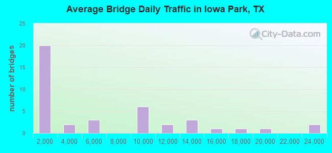
- 239,454Total average daily traffic
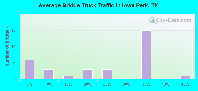
- 58,808Total average daily truck traffic
- National Bridge Inventory (NBI) Registered Bridges for Iowa Park
- No street view available for this location
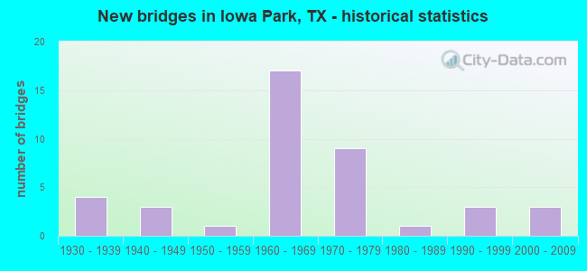
- New bridges - historical statistics
- 41930-1939
- 31940-1949
- 11950-1959
- 171960-1969
- 91970-1979
- 11980-1989
- 31990-1999
- 32000-2009
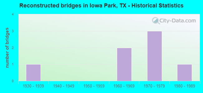
- Reconstructed bridges - Historical Statistics
- 11930-1939
- 01940-1949
- 01950-1959
- 21960-1969
- 31970-1979
- 11980-1989
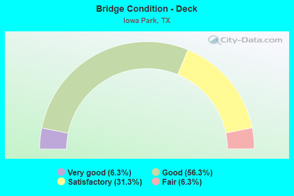
- Bridge Condition - Deck
- 6.3%Very good
- 56.3%Good
- 31.3%Satisfactory
- 6.3%Fair
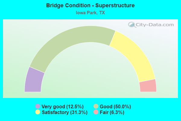
- Bridge Condition - Superstructure
- 12.5%Very good
- 50.0%Good
- 31.3%Satisfactory
- 6.3%Fair
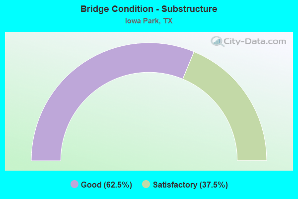
- Bridge Condition - Substructure
- 62.5%Good
- 37.5%Satisfactory
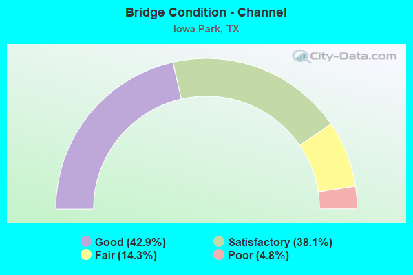
- Bridge Condition - Channel
- 42.9%Good
- 38.1%Satisfactory
- 14.3%Fair
- 4.8%Poor
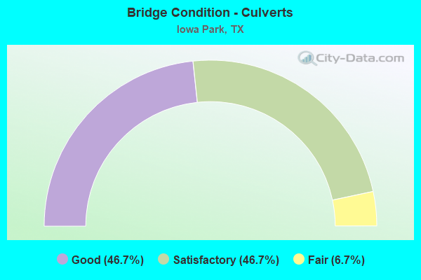
- Bridge Condition - Culverts
- 46.7%Good
- 46.7%Satisfactory
- 6.7%Fair
Find on map >> Show street view
Structure Number: 32430004308052, Location: 1.1 MI E OF BURNETT RD (Lat: 33.971100, Lng: -98.749578), Route carried "on" structure: US 287, Year Built: 1940, Year Reconstructed: 1970, Status: Open, Structure Length: 1.01m (3.31ft), Average Daily Traffic: 12,227 (year 2020), Truck Traffic: 30%, Average Future Daily Traffic: 23,310 (year 2033), Design Load: HS 15, Features Intersected: NORTH FORK BUFFALO CREEK
Minimum Vertical Clearance: 30+ m (98+ ft), Kilometerpoint: 21.375, Lanes on structure: 4, Owner: State Highway Agency, Approaching Roadway Width: 25.0m (82.0ft), Skew: 20 degrees, Material/Design: Concrete, Design/Construction: Culvert, Number Of Spans In Main Unit: 3, Length of Maximum Span: 3.0m (9.8ft)
Condition: Channel: Good, Culverts: Satisfactory, Operating Rating: 39.9 metric tons, Method Used To Determine Operating Rating: Load Factor (LF), Inventory Rating: 23.6 metric tons, Method Used To Determine Inventory Rating: Load Factor (LF), Structural Evaluation: Somewhat better than minimum adequacy, Waterway Adequacy: Equal to present minimum criteria, Approach Roadway Alignment: Equal to present desirable criteria, Designated Inspection Frequency: Every 24 months, Inspection Date: May 2020
Find on map >> Show street view
Structure Number: 32430004308053, Location: 1.15 MI W OF BUS 287 (Lat: 33.965681, Lng: -98.710419), Route carried "on" structure: US 287, Year Built: 1940, Year Reconstructed: 1970, Status: Open, Structure Length: 1.68m (5.51ft), Average Daily Traffic: 12,227 (year 2020), Truck Traffic: 30%, Average Future Daily Traffic: 23,310 (year 2033), Design Load: H 15, Features Intersected: STEVENS CREEK
Minimum Vertical Clearance: 30+ m (98+ ft), Kilometerpoint: 25.080, Lanes on structure: 4, Owner: State Highway Agency, Approaching Roadway Width: 23.8m (78.1ft), Skew: 29 degrees, Material/Design: Concrete, Design/Construction: Culvert, Number Of Spans In Main Unit: 5, Length of Maximum Span: 3.0m (9.8ft)
Condition: Channel: Good, Culverts: Good, Operating Rating: 39.9 metric tons, Method Used To Determine Operating Rating: Load Factor (LF), Inventory Rating: 23.6 metric tons, Method Used To Determine Inventory Rating: Load Factor (LF), Structural Evaluation: Somewhat better than minimum adequacy, Waterway Adequacy: Equal to present minimum criteria, Approach Roadway Alignment: Equal to present desirable criteria, Designated Inspection Frequency: Every 24 months, Inspection Date: May 2020
Find on map >> Show street view
Structure Number: 32430004308136, Location: 3.4 MI E OF BUS 287/LP477 (Lat: 33.971261, Lng: -98.769128), Route carried "on" structure: US 287, Year Built: 1970, Status: Open, Structure Length: 5.49m (18.01ft), Average Daily Traffic: 8,320 (year 2013), Truck Traffic: 30%, Average Future Daily Traffic: 11,650 (year 2033), Design Load: HS 20, Features Intersected: BURNETT RD
Minimum Vertical Clearance: 30+ m (98+ ft), Kilometerpoint: 19.528, Lanes on structure: 2, Lanes under structure: 2, Owner: State Highway Agency, Approaching Roadway Width: 12.2m (40.0ft), Material/Design: Prestressed concrete, Design/Construction: Stringer/Multi-beam, Number Of Spans In Main Unit: 3, Length of Maximum Span: 19.8m (65.0ft), Curb-To-Curb Width: 11.9m (39.0ft), Out-to-Out Width: 12.8m (42.0ft)
Condition: Deck: Good, Superstructure: Good, Substructure: Satisfactory, Operating Rating: 32.7 metric tons, Method Used To Determine Operating Rating: Assigned ratings based on Allowable Stress Design (ASD) reported in metric tons, Inventory Rating: 24.5 metric tons, Method Used To Determine Inventory Rating: Assigned ratings based on Allowable Stress Design (ASD) reported in metric tons, Structural Evaluation: Equal to present minimum criteria, Deck Geometry: Better than present minimum criteria, Underclear: Better than present minimum criteria, Approach Roadway Alignment: Equal to present desirable criteria, Designated Inspection Frequency: Every 24 months, Inspection Date: May 2020, Deck Structure Type: Concrete Cast-file-Place, Wearing Surface/Protective System: Wearing Surface: Bituminous
Find on map >> Show street view
Structure Number: 32430004308138, Location: 0.1 MI W OF HARMONY RD (Lat: 33.967575, Lng: -98.727239), Route carried "on" structure: US 287, Year Built: 1970, Status: Open, Structure Length: 0.67m (2.20ft), Average Daily Traffic: 12,227 (year 2020), Truck Traffic: 30%, Average Future Daily Traffic: 23,310 (year 2033), Design Load: HS 20, Features Intersected: TRIB OF BUFFALO CREEK
Minimum Vertical Clearance: 30+ m (98+ ft), Kilometerpoint: 23.530, Lanes on structure: 6, Owner: State Highway Agency, Approaching Roadway Width: 32.0m (105.0ft), Skew: 20 degrees, Material/Design: Concrete, Design/Construction: Culvert, Number Of Spans In Main Unit: 3, Length of Maximum Span: 2.1m (6.9ft)
Condition: Channel: Satisfactory, Culverts: Good, Operating Rating: 39.9 metric tons, Method Used To Determine Operating Rating: Load Factor (LF), Inventory Rating: 23.6 metric tons, Method Used To Determine Inventory Rating: Load Factor (LF), Structural Evaluation: Somewhat better than minimum adequacy, Waterway Adequacy: Equal to present minimum criteria, Approach Roadway Alignment: Equal to present desirable criteria, Designated Inspection Frequency: Every 24 months, Inspection Date: May 2020
Find on map >> Show street view
Structure Number: 32430004308139, Location: 2.00 MI W OF BUS 287 (Lat: 33.966908, Lng: -98.725533), Route carried "on" structure: County highway , Year Built: 1970, Status: Open, Structure Length: 7.92m (25.98ft), Average Daily Traffic: 170 (year 2010), Average Future Daily Traffic: 350 (year 2030), Design Load: H 20, Features Intersected: US 287, Facility Carried by Structure: HARMONY RD
Minimum Vertical Clearance: 30+ m (98+ ft), Kilometerpoint: 2.897, Lanes on structure: 2, Lanes under structure: 4, Base Highway Network: Yes, Owner: State Highway Agency, Approaching Roadway Width: 6.7m (22.0ft), Skew: 2 degrees, Material/Design: Prestressed concrete, Design/Construction: Stringer/Multi-beam, Number Of Spans In Main Unit: 2, Number Of Approach Spans: 2, Length of Maximum Span: 25.9m (85.0ft), Curb-To-Curb Width: 7.9m (25.9ft), Out-to-Out Width: 8.6m (28.2ft)
Condition: Deck: Good, Superstructure: Satisfactory, Substructure: Good, Operating Rating: 51.7 metric tons, Method Used To Determine Operating Rating: Load Factor (LF), Inventory Rating: 27.2 metric tons, Method Used To Determine Inventory Rating: Load Factor (LF), Structural Evaluation: Equal to present minimum criteria, Deck Geometry: Somewhat better than minimum adequacy, Underclear: Superior to present desirable criteria, Approach Roadway Alignment: Equal to present desirable criteria, Designated Inspection Frequency: Every 24 months, Inspection Date: May 2020, Deck Structure Type: Concrete Cast-file-Place
Find on map >> Show street view
Structure Number: 3243000430814, Location: 1.2 MI W OF BUS 287 (Lat: 33.966325, Lng: -98.709981), Route carried "on" structure: Ramp US 287, Year Built: 1970, Status: Open, Structure Length: 0.94m (3.08ft), Average Daily Traffic: 1,660 (year 2013), Truck Traffic: 30%, Average Future Daily Traffic: 2,330 (year 2033), Design Load: HS 20, Features Intersected: STEVENS CREEK
Minimum Vertical Clearance: 30+ m (98+ ft), Kilometerpoint: 24.121, Lanes on structure: 1, Owner: State Highway Agency, Approaching Roadway Width: 11.0m (36.1ft), Material/Design: Concrete, Design/Construction: Culvert, Number Of Spans In Main Unit: 4, Length of Maximum Span: 2.1m (6.9ft)
Condition: Channel: Good, Culverts: Satisfactory, Operating Rating: 39.9 metric tons, Method Used To Determine Operating Rating: Load Factor (LF), Inventory Rating: 23.6 metric tons, Method Used To Determine Inventory Rating: Load Factor (LF), Structural Evaluation: Equal to present minimum criteria, Waterway Adequacy: Equal to present minimum criteria, Approach Roadway Alignment: Equal to present desirable criteria, Designated Inspection Frequency: Every 24 months, Inspection Date: May 2020
Find on map >> Show street view
Structure Number: 32430004308141, Location: 1.15 MI W OF BUS 287 (Lat: 33.966808, Lng: -98.709958), Route carried "on" structure: ServiceUS 287, Year Built: 1970, Status: Open, Structure Length: 0.76m (2.49ft), Average Daily Traffic: 30 (year 2013), Truck Traffic: 34%, Average Future Daily Traffic: 50 (year 2033), Design Load: HS 20, Features Intersected: STEVENS CREEK
Minimum Vertical Clearance: 30+ m (98+ ft), Kilometerpoint: 25.080, Lanes on structure: 2, Owner: State Highway Agency, Approaching Roadway Width: 6.1m (20.0ft), Skew: 4 degrees, Material/Design: Concrete, Design/Construction: Culvert, Number Of Spans In Main Unit: 2, Length of Maximum Span: 2.4m (7.9ft)
Condition: Channel: Good, Culverts: Good, Operating Rating: 39.9 metric tons, Method Used To Determine Operating Rating: Load Factor (LF), Inventory Rating: 23.6 metric tons, Method Used To Determine Inventory Rating: Load Factor (LF), Structural Evaluation: Equal to present minimum criteria, Waterway Adequacy: Equal to present minimum criteria, Approach Roadway Alignment: Equal to present desirable criteria, Designated Inspection Frequency: Every 24 months, Inspection Date: May 2020
Find on map >> Show street view
Structure Number: 32430004308163, Location: 3.4 MI E OF BUS 287/LP477 (Lat: 33.971439, Lng: -98.769128), Route carried "on" structure: US 287, Year Built: 1970, Status: Open, Structure Length: 5.49m (18.01ft), Average Daily Traffic: 8,320 (year 2013), Truck Traffic: 30%, Average Future Daily Traffic: 11,650 (year 2033), Design Load: HS 20, Features Intersected: BURNETT RD
Minimum Vertical Clearance: 30+ m (98+ ft), Kilometerpoint: 19.528, Lanes on structure: 2, Lanes under structure: 2, Owner: State Highway Agency, Approaching Roadway Width: 12.2m (40.0ft), Material/Design: Prestressed concrete, Design/Construction: Stringer/Multi-beam, Number Of Spans In Main Unit: 3, Length of Maximum Span: 19.8m (65.0ft), Curb-To-Curb Width: 11.9m (39.0ft), Out-to-Out Width: 12.8m (42.0ft)
Condition: Deck: Good, Superstructure: Good, Substructure: Satisfactory, Operating Rating: 32.7 metric tons, Method Used To Determine Operating Rating: Assigned ratings based on Allowable Stress Design (ASD) reported in metric tons, Inventory Rating: 24.5 metric tons, Method Used To Determine Inventory Rating: Assigned ratings based on Allowable Stress Design (ASD) reported in metric tons, Structural Evaluation: Equal to present minimum criteria, Deck Geometry: Better than present minimum criteria, Underclear: Equal to present minimum criteria, Approach Roadway Alignment: Equal to present desirable criteria, Designated Inspection Frequency: Every 24 months, Inspection Date: May 2020, Deck Structure Type: Concrete Cast-file-Place, Wearing Surface/Protective System: Wearing Surface: Bituminous
Find on map >> Show street view
Structure Number: 32430004309075, Location: 1.00 MI W OF FM 368 (Lat: 33.965869, Lng: -98.690544), Route carried "on" structure: US 287, Year Built: 1961, Status: Open, Structure Length: 5.06m (16.60ft), Average Daily Traffic: 8,320 (year 2013), Truck Traffic: 30%, Average Future Daily Traffic: 11,650 (year 2033), Design Load: HS 20, Features Intersected: BU 287
Minimum Vertical Clearance: 30+ m (98+ ft), Kilometerpoint: 30.796, Lanes on structure: 2, Lanes under structure: 4, Owner: State Highway Agency, Approaching Roadway Width: 12.2m (40.0ft), Material/Design: Concrete continuous, Design/Construction: Slab, Number Of Spans In Main Unit: 4, Length of Maximum Span: 13.7m (44.9ft), Curb-To-Curb Width: 11.8m (38.7ft), Out-to-Out Width: 12.7m (41.7ft)
Condition: Deck: Good, Superstructure: Good, Substructure: Good, Operating Rating: 66.2 metric tons, Method Used To Determine Operating Rating: Load Factor (LF), Inventory Rating: 39.9 metric tons, Method Used To Determine Inventory Rating: Load Factor (LF), Structural Evaluation: Better than present minimum criteria, Deck Geometry: Equal to present minimum criteria, Underclear: Somewhat better than minimum adequacy, Approach Roadway Alignment: Equal to present desirable criteria, Designated Inspection Frequency: Every 24 months, Inspection Date: May 2020, Deck Structure Type: Concrete Cast-file-Place, Wearing Surface/Protective System: Wearing Surface: Bituminous
Find on map >> Show street view
Structure Number: 32430004309076, Location: 1.00 MI W OF FM 368 (Lat: 33.965686, Lng: -98.690561), Route carried "on" structure: US 287, Year Built: 1961, Status: Open, Structure Length: 5.06m (16.60ft), Average Daily Traffic: 8,320 (year 2013), Truck Traffic: 30%, Average Future Daily Traffic: 11,650 (year 2033), Design Load: HS 20, Features Intersected: BU 287
Minimum Vertical Clearance: 30+ m (98+ ft), Kilometerpoint: 30.796, Lanes on structure: 2, Lanes under structure: 4, Base Highway Network: Yes, Owner: State Highway Agency, Approaching Roadway Width: 12.2m (40.0ft), Material/Design: Concrete continuous, Design/Construction: Slab, Number Of Spans In Main Unit: 4, Length of Maximum Span: 13.7m (44.9ft), Curb-To-Curb Width: 11.8m (38.7ft), Out-to-Out Width: 12.7m (41.7ft)
Condition: Deck: Satisfactory, Superstructure: Satisfactory, Substructure: Good, Operating Rating: 66.2 metric tons, Method Used To Determine Operating Rating: Load Factor (LF), Inventory Rating: 39.9 metric tons, Method Used To Determine Inventory Rating: Load Factor (LF), Structural Evaluation: Equal to present minimum criteria, Deck Geometry: Equal to present minimum criteria, Underclear: Somewhat better than minimum adequacy, Approach Roadway Alignment: Equal to present desirable criteria, Designated Inspection Frequency: Every 24 months, Inspection Date: May 2020, Deck Structure Type: Concrete Cast-file-Place, Wearing Surface/Protective System: Wearing Surface: Bituminous
Find on map >> Show street view
Structure Number: 32430004309077, Location: 0.13 MI E OF BUS 287 (Lat: 33.965764, Lng: -98.688381), Route carried "on" structure: US 287, Year Built: 1961, Status: Open, Structure Length: 0.94m (3.08ft), Average Daily Traffic: 18,075 (year 2019), Truck Traffic: 30%, Average Future Daily Traffic: 25,300 (year 2033), Features Intersected: TRIB OF BUFFALO CREEK
Minimum Vertical Clearance: 30+ m (98+ ft), Kilometerpoint: 31.028, Lanes on structure: 8, Owner: State Highway Agency, Approaching Roadway Width: 38.4m (126.0ft), Skew: 24 degrees, Material/Design: Concrete, Design/Construction: Culvert, Number Of Spans In Main Unit: 3, Length of Maximum Span: 2.1m (6.9ft)
Condition: Channel: Fair, Culverts: Satisfactory, Operating Rating: 39.9 metric tons, Method Used To Determine Operating Rating: Load Factor (LF), Inventory Rating: 23.6 metric tons, Method Used To Determine Inventory Rating: Load Factor (LF), Structural Evaluation: Somewhat better than minimum adequacy, Waterway Adequacy: Equal to present minimum criteria, Approach Roadway Alignment: Equal to present desirable criteria, Designated Inspection Frequency: Every 24 months, Inspection Date: May 2020
Find on map >> Show street view
Structure Number: 32430004309078, Location: 1.0 MI E OF BUS 287 (Lat: 33.965861, Lng: -98.673053), Route carried "on" structure: US 287, Year Built: 1961, Status: Open, Structure Length: 5.06m (16.60ft), Average Daily Traffic: 9,030 (year 2013), Truck Traffic: 30%, Average Future Daily Traffic: 12,650 (year 2033), Design Load: HS 20, Features Intersected: FM 368
Minimum Vertical Clearance: 30+ m (98+ ft), Kilometerpoint: 32.411, Lanes on structure: 2, Lanes under structure: 2, Owner: State Highway Agency, Approaching Roadway Width: 12.2m (40.0ft), Material/Design: Concrete continuous, Design/Construction: Slab, Number Of Spans In Main Unit: 4, Length of Maximum Span: 13.7m (44.9ft), Curb-To-Curb Width: 11.8m (38.7ft), Out-to-Out Width: 12.7m (41.7ft)
Condition: Deck: Good, Superstructure: Good, Substructure: Good, Operating Rating: 66.2 metric tons, Method Used To Determine Operating Rating: Load Factor (LF), Inventory Rating: 39.9 metric tons, Method Used To Determine Inventory Rating: Load Factor (LF), Structural Evaluation: Better than present minimum criteria, Deck Geometry: Equal to present minimum criteria, Underclear: Better than present minimum criteria, Approach Roadway Alignment: Equal to present desirable criteria, Designated Inspection Frequency: Every 24 months, Inspection Date: July 2020, Deck Structure Type: Concrete Cast-file-Place, Wearing Surface/Protective System: Wearing Surface: Bituminous
Find on map >> Show street view
Structure Number: 32430004309079, Location: 1.0 MI E OF BUS 287 (Lat: 33.965681, Lng: -98.673047), Route carried "on" structure: US 287, Year Built: 1961, Status: Open, Structure Length: 5.06m (16.60ft), Average Daily Traffic: 9,030 (year 2013), Truck Traffic: 30%, Average Future Daily Traffic: 12,650 (year 2033), Design Load: HS 20, Features Intersected: FM 368
Minimum Vertical Clearance: 30+ m (98+ ft), Kilometerpoint: 32.411, Lanes on structure: 2, Lanes under structure: 2, Owner: State Highway Agency, Approaching Roadway Width: 12.2m (40.0ft), Material/Design: Concrete continuous, Design/Construction: Slab, Number Of Spans In Main Unit: 4, Length of Maximum Span: 13.7m (44.9ft), Curb-To-Curb Width: 11.8m (38.7ft), Out-to-Out Width: 12.7m (41.7ft)
Condition: Deck: Good, Superstructure: Good, Substructure: Good, Operating Rating: 66.2 metric tons, Method Used To Determine Operating Rating: Load Factor (LF), Inventory Rating: 39.9 metric tons, Method Used To Determine Inventory Rating: Load Factor (LF), Structural Evaluation: Better than present minimum criteria, Deck Geometry: Equal to present minimum criteria, Underclear: Equal to present minimum criteria, Approach Roadway Alignment: Equal to present desirable criteria, Designated Inspection Frequency: Every 24 months, Inspection Date: July 2020, Deck Structure Type: Concrete Cast-file-Place, Wearing Surface/Protective System: Wearing Surface: Bituminous
Find on map >> Show street view
Structure Number: 3243000430908, Location: 0.18 MI E OF FM 368 (Lat: 33.965764, Lng: -98.669800), Route carried "on" structure: US 287, Year Built: 1961, Status: Open, Structure Length: 0.88m (2.89ft), Average Daily Traffic: 14,099 (year 2020), Truck Traffic: 30%, Average Future Daily Traffic: 29,130 (year 2033), Features Intersected: DRAW
Minimum Vertical Clearance: 30+ m (98+ ft), Kilometerpoint: 32.737, Lanes on structure: 8, Owner: State Highway Agency, Approaching Roadway Width: 37.2m (122.0ft), Skew: 20 degrees, Material/Design: Concrete, Design/Construction: Culvert, Number Of Spans In Main Unit: 5, Length of Maximum Span: 1.5m (4.9ft)
Condition: Channel: Satisfactory, Culverts: Satisfactory, Operating Rating: 39.9 metric tons, Method Used To Determine Operating Rating: Load Factor (LF), Inventory Rating: 23.6 metric tons, Method Used To Determine Inventory Rating: Load Factor (LF), Structural Evaluation: Somewhat better than minimum adequacy, Waterway Adequacy: Equal to present minimum criteria, Approach Roadway Alignment: Equal to present desirable criteria, Designated Inspection Frequency: Every 24 months, Inspection Date: May 2020
Find on map >> Show street view
Structure Number: 32430004309081, Location: 1.00 MI E OF FM 368 (Lat: 33.964264, Lng: -98.655558), Route carried "on" structure: US 287, Year Built: 1961, Status: Open, Structure Length: 3.90m (12.80ft), Average Daily Traffic: 10,400 (year 2013), Truck Traffic: 30%, Average Future Daily Traffic: 14,560 (year 2033), Design Load: HS 20, Features Intersected: BELL RD
Minimum Vertical Clearance: 30+ m (98+ ft), Kilometerpoint: 34.049, Lanes on structure: 2, Lanes under structure: 2, Owner: State Highway Agency, Approaching Roadway Width: 12.2m (40.0ft), Skew: 1 degrees, Material/Design: Concrete continuous, Design/Construction: Slab, Number Of Spans In Main Unit: 3, Length of Maximum Span: 14.3m (46.9ft), Curb-To-Curb Width: 11.8m (38.7ft), Out-to-Out Width: 12.7m (41.7ft)
Condition: Deck: Satisfactory, Superstructure: Satisfactory, Substructure: Good, Operating Rating: 58.0 metric tons, Method Used To Determine Operating Rating: Load Factor (LF), Inventory Rating: 34.5 metric tons, Method Used To Determine Inventory Rating: Load Factor (LF), Structural Evaluation: Equal to present minimum criteria, Deck Geometry: Equal to present minimum criteria, Underclear: Equal to present minimum criteria, Approach Roadway Alignment: Equal to present desirable criteria, Designated Inspection Frequency: Every 24 months, Inspection Date: May 2020, Deck Structure Type: Concrete Cast-file-Place, Wearing Surface/Protective System: Wearing Surface: Bituminous
Find on map >> Show street view
Structure Number: 32430004309082, Location: 1.00 MI E OF FM 368 (Lat: 33.964083, Lng: -98.655558), Route carried "on" structure: US 287, Year Built: 1961, Status: Open, Structure Length: 3.90m (12.80ft), Average Daily Traffic: 11,490 (year 2013), Truck Traffic: 21%, Average Future Daily Traffic: 16,090 (year 2033), Design Load: HS 20, Features Intersected: BELL RD
Minimum Vertical Clearance: 30+ m (98+ ft), Kilometerpoint: 34.068, Lanes on structure: 2, Lanes under structure: 2, Owner: State Highway Agency, Approaching Roadway Width: 12.2m (40.0ft), Skew: 1 degrees, Material/Design: Concrete continuous, Design/Construction: Slab, Number Of Spans In Main Unit: 3, Length of Maximum Span: 14.3m (46.9ft), Curb-To-Curb Width: 11.8m (38.7ft), Out-to-Out Width: 12.7m (41.7ft)
Condition: Deck: Good, Superstructure: Good, Substructure: Good, Operating Rating: 58.0 metric tons, Method Used To Determine Operating Rating: Load Factor (LF), Inventory Rating: 34.5 metric tons, Method Used To Determine Inventory Rating: Load Factor (LF), Structural Evaluation: Better than present minimum criteria, Deck Geometry: Equal to present minimum criteria, Underclear: Equal to present minimum criteria, Approach Roadway Alignment: Equal to present desirable criteria, Designated Inspection Frequency: Every 24 months, Inspection Date: May 2020, Deck Structure Type: Concrete Cast-file-Place, Wearing Surface/Protective System: Wearing Surface: Bituminous
Find on map >> Show street view
Structure Number: 32430004309083, Location: 1.83 MI E OF FM 368 (Lat: 33.962011, Lng: -98.641736), Route carried "on" structure: US 287, Year Built: 1961, Year Reconstructed: 1970, Status: Open, Structure Length: 1.34m (4.40ft), Average Daily Traffic: 22,990 (year 2013), Truck Traffic: 21%, Average Future Daily Traffic: 32,190 (year 2033), Features Intersected: WEST FORK OF POND CREEK
Minimum Vertical Clearance: 30+ m (98+ ft), Kilometerpoint: 35.359, Lanes on structure: 4, Owner: State Highway Agency, Approaching Roadway Width: 24.4m (80.1ft), Skew: 20 degrees, Material/Design: Concrete, Design/Construction: Culvert, Number Of Spans In Main Unit: 5, Length of Maximum Span: 2.4m (7.9ft)
Condition: Channel: Good, Culverts: Satisfactory, Operating Rating: 39.9 metric tons, Method Used To Determine Operating Rating: Load Factor (LF), Inventory Rating: 23.6 metric tons, Method Used To Determine Inventory Rating: Load Factor (LF), Structural Evaluation: Somewhat better than minimum adequacy, Waterway Adequacy: Equal to present minimum criteria, Approach Roadway Alignment: Equal to present desirable criteria, Designated Inspection Frequency: Every 24 months, Inspection Date: May 2020
Find on map >> Show street view
Structure Number: 3243000430918, Location: 2.05 MI W OF FM 369 (Lat: 33.961481, Lng: -98.638450), Route carried "on" structure: County highway 121, Year Built: 1991, Status: Open, Structure Length: 12.19m (39.99ft), Average Daily Traffic: 229 (year 2020), Truck Traffic: 1%, Average Future Daily Traffic: 500 (year 2028), Design Load: HS 20, Features Intersected: US 287, Facility Carried by Structure: PETERSON RD
Minimum Vertical Clearance: 30+ m (98+ ft), Kilometerpoint: 1.674, Lanes on structure: 2, Lanes under structure: 6, Owner: State Highway Agency, Approaching Roadway Width: 7.3m (24.0ft), Skew: 1 degrees, Material/Design: Prestressed concrete, Design/Construction: Stringer/Multi-beam, Number Of Spans In Main Unit: 4, Number Of Approach Spans: 2, Length of Maximum Span: 24.4m (80.1ft), Curb-To-Curb Width: 8.5m (27.9ft), Out-to-Out Width: 9.1m (29.9ft)
Condition: Deck: Satisfactory, Superstructure: Satisfactory, Substructure: Good, Operating Rating: 54.4 metric tons, Method Used To Determine Operating Rating: Assigned rating based on Load Factor Design (LFD) reported in metric tons, Inventory Rating: 32.7 metric tons, Method Used To Determine Inventory Rating: Assigned rating based on Load Factor Design (LFD) reported in metric tons, Structural Evaluation: Equal to present minimum criteria, Deck Geometry: Equal to present minimum criteria, Underclear: Superior to present desirable criteria, Approach Roadway Alignment: Equal to present desirable criteria, Designated Inspection Frequency: Every 24 months, Inspection Date: May 2020, Deck Structure Type: Concrete Cast-file-Place
Find on map >> Show street view
Structure Number: 32430004317043, Location: 0.80 MI E OF FM 1814 (Lat: 33.946942, Lng: -98.641542), Route carried "on" structure: Business State highway 287, Year Built: 1936, Year Reconstructed: 1939, Status: Open, Structure Length: 1.31m (4.30ft), Average Daily Traffic: 4,020 (year 2013), Truck Traffic: 8%, Average Future Daily Traffic: 5,620 (year 2033), Design Load: H 15, Features Intersected: WEST FORK OF POND CREEK
Minimum Vertical Clearance: 30+ m (98+ ft), Kilometerpoint: 31.453, Lanes on structure: 4, Owner: State Highway Agency, Approaching Roadway Width: 16.5m (54.1ft), Skew: 20 degrees, Material/Design: Concrete, Design/Construction: Culvert, Number Of Spans In Main Unit: 4, Length of Maximum Span: 3.0m (9.8ft), Curb-To-Curb Width: 19.4m (63.6ft), Out-to-Out Width: 20.5m (67.3ft)
Condition: Channel: Satisfactory, Culverts: Satisfactory, Operating Rating: 39.9 metric tons, Method Used To Determine Operating Rating: Load Factor (LF), Inventory Rating: 23.6 metric tons, Method Used To Determine Inventory Rating: Load Factor (LF), Structural Evaluation: Equal to present minimum criteria, Deck Geometry: Better than present minimum criteria, Waterway Adequacy: Equal to present minimum criteria, Approach Roadway Alignment: Equal to present desirable criteria, Designated Inspection Frequency: Every 24 months, Inspection Date: May 2020, Deck Structure Type: Concrete Cast-file-Place, Wearing Surface/Protective System: Wearing Surface: Bituminous
Find on map >> Show street view
Structure Number: 32430004317164, Location: 0.5 MI S OF US 287 (Lat: 33.961133, Lng: -98.685889), Route carried "on" structure: Business State highway 287, Year Built: 1940, Year Reconstructed: 1992, Status: Open, Structure Length: 0.70m (2.30ft), Average Daily Traffic: 3,560 (year 2013), Truck Traffic: 8%, Average Future Daily Traffic: 4,980 (year 2033), Design Load: H 15, Features Intersected: TRIB OF BUFFALO CREEK
Minimum Vertical Clearance: 30+ m (98+ ft), Kilometerpoint: 26.836, Lanes on structure: 3, Owner: State Highway Agency, Approaching Roadway Width: 14.0m (45.9ft), Skew: 4 degrees, Material/Design: Concrete, Design/Construction: Culvert, Number Of Spans In Main Unit: 3, Length of Maximum Span: 1.5m (4.9ft), Curb-To-Curb Width: 14.2m (46.6ft), Out-to-Out Width: 21.5m (70.5ft)
Condition: Channel: Good, Culverts: Good, Operating Rating: 39.9 metric tons, Method Used To Determine Operating Rating: Load Factor (LF), Inventory Rating: 23.6 metric tons, Method Used To Determine Inventory Rating: Load Factor (LF), Structural Evaluation: Equal to present minimum criteria, Deck Geometry: Somewhat better than minimum adequacy, Waterway Adequacy: Equal to present minimum criteria, Approach Roadway Alignment: Equal to present desirable criteria, Designated Inspection Frequency: Every 24 months, Inspection Date: May 2020, Deck Structure Type: Concrete Cast-file-Place, Wearing Surface/Protective System: Wearing Surface: Bituminous
Find on map >> Show street view
Structure Number: 32430068104012, Location: 1.6 MI W OF FM 368 (Lat: 33.922189, Lng: -98.732631), Route carried "on" structure: State highway 367, Year Built: 1930, Status: Open, Structure Length: 0.82m (2.69ft), Average Daily Traffic: 292 (year 2020), Truck Traffic: 19%, Average Future Daily Traffic: 410 (year 2033), Features Intersected: DEEP CREEK
Minimum Vertical Clearance: 30+ m (98+ ft), Kilometerpoint: 12.968, Lanes on structure: 2, Owner: State Highway Agency, Approaching Roadway Width: 6.1m (20.0ft), Material/Design: Concrete, Design/Construction: Culvert, Number Of Spans In Main Unit: 4, Length of Maximum Span: 1.8m (5.9ft)
Condition: Channel: Fair, Culverts: Satisfactory, Operating Rating: 32.7 metric tons, Method Used To Determine Operating Rating: Field evaluation and documented engineering judgment, Inventory Rating: 24.5 metric tons, Method Used To Determine Inventory Rating: Field evaluation and documented engineering judgment, Structural Evaluation: Equal to present minimum criteria, Waterway Adequacy: Equal to present minimum criteria, Approach Roadway Alignment: Equal to present desirable criteria, Length Of Structure Improvement: 0.79m (2.59ft), Designated Inspection Frequency: Every 24 months, Inspection Date: June 2020
Find on map >> Show street view
Structure Number: 32430068104013, Location: 0.40 MI W OF FM 368 (Lat: 33.926044, Lng: -98.678814), Route carried "on" structure: State highway 367, Year Built: 1930, Year Reconstructed: 1966, Status: Open, Structure Length: 0.67m (2.20ft), Average Daily Traffic: 1,593 (year 2020), Truck Traffic: 19%, Average Future Daily Traffic: 2,330 (year 2033), Features Intersected: DRAW
Minimum Vertical Clearance: 30+ m (98+ ft), Kilometerpoint: 18.005, Lanes on structure: 2, Owner: State Highway Agency, Approaching Roadway Width: 7.3m (24.0ft), Material/Design: Concrete, Design/Construction: Culvert, Number Of Spans In Main Unit: 2, Length of Maximum Span: 3.0m (9.8ft)
Condition: Channel: Good, Culverts: Fair, Operating Rating: 32.7 metric tons, Method Used To Determine Operating Rating: Field evaluation and documented engineering judgment, Inventory Rating: 24.5 metric tons, Method Used To Determine Inventory Rating: Field evaluation and documented engineering judgment, Structural Evaluation: Somewhat better than minimum adequacy, Waterway Adequacy: Equal to present minimum criteria, Approach Roadway Alignment: Equal to present desirable criteria, Length Of Structure Improvement: 0.70m (2.30ft), Designated Inspection Frequency: Every 24 months, Inspection Date: June 2020
Find on map >> Show street view
Structure Number: 32430068104014, Location: 0.38 MI W OF FM 368 N (Lat: 33.926044, Lng: -98.678100), Route carried "on" structure: State highway 367, Year Built: 1930, Year Reconstructed: 1966, Status: Open, Structure Length: 1.46m (4.79ft), Average Daily Traffic: 1,593 (year 2020), Truck Traffic: 19%, Average Future Daily Traffic: 2,330 (year 2033), Features Intersected: BUFFALO CREEK
Minimum Vertical Clearance: 30+ m (98+ ft), Kilometerpoint: 18.066, Lanes on structure: 2, Owner: State Highway Agency, Approaching Roadway Width: 7.3m (24.0ft), Material/Design: Steel, Design/Construction: Stringer/Multi-beam, Number Of Spans In Main Unit: 1, Length of Maximum Span: 12.2m (40.0ft), Curb-To-Curb Width: 9.7m (31.8ft), Out-to-Out Width: 12.9m (42.3ft)
Condition: Deck: Satisfactory, Superstructure: Good, Substructure: Satisfactory, Channel: Satisfactory, Operating Rating: 49.9 metric tons, Method Used To Determine Operating Rating: Load Factor (LF), Inventory Rating: 29.9 metric tons, Method Used To Determine Inventory Rating: Load Factor (LF), Structural Evaluation: Equal to present minimum criteria, Deck Geometry: Somewhat better than minimum adequacy, Waterway Adequacy: Equal to present minimum criteria, Approach Roadway Alignment: Equal to present desirable criteria, Designated Inspection Frequency: Every 24 months, Inspection Date: June 2020, Deck Structure Type: Concrete Cast-file-Place, Wearing Surface/Protective System: Wearing Surface: Bituminous
Find on map >> Show street view
Structure Number: 32430080401016, Location: 0.15 N OF FM 1206 (Lat: 33.896878, Lng: -98.707267), Route carried "on" structure: State highway 368, Year Built: 2005, Status: Open, Structure Length: 7.32m (24.02ft), Average Daily Traffic: 1,042 (year 2020), Truck Traffic: 1%, Average Future Daily Traffic: 1,610 (year 2033), Design Load: HL 93, Features Intersected: WICHITA RIVER
Minimum Vertical Clearance: 30+ m (98+ ft), Kilometerpoint: 5.020, Lanes on structure: 2, Owner: State Highway Agency, Approaching Roadway Width: 7.3m (24.0ft), Material/Design: Steel, Design/Construction: Stringer/Multi-beam, Number Of Spans In Main Unit: 3, Length of Maximum Span: 24.4m (80.1ft), Curb-To-Curb Width: 13.3m (43.6ft), Out-to-Out Width: 14.0m (45.9ft)
Condition: Deck: Good, Superstructure: Very good, Substructure: Good, Channel: Satisfactory, Operating Rating: 54.4 metric tons, Method Used To Determine Operating Rating: Assigned ratings based on Load and Resistance Factor Design (LRFD) reported in metric tons, Inventory Rating: 32.7 metric tons, Method Used To Determine Inventory Rating: Assigned ratings based on Load and Resistance Factor Design (LRFD) reported in metric tons, Structural Evaluation: Better than present minimum criteria, Deck Geometry: Better than present minimum criteria, Waterway Adequacy: Equal to present minimum criteria, Approach Roadway Alignment: Equal to present desirable criteria, Designated Inspection Frequency: Every 24 months, Inspection Date: June 2020, Deck Structure Type: Concrete Precast Panels, Wearing Surface/Protective System: Deck Protection: Epoxy Coated Reinforcing
Find on map >> Show street view
Structure Number: 32430080404015, Location: 0.5 MI N OF US 287 (Lat: 33.973189, Lng: -98.673061), Route carried "on" structure: State highway 368, Year Built: 2001, Status: Open, Structure Length: 1.65m (5.41ft), Average Daily Traffic: 922 (year 2020), Truck Traffic: 1%, Average Future Daily Traffic: 1,000 (year 2033), Design Load: HS 20, Features Intersected: DRAW
Minimum Vertical Clearance: 30+ m (98+ ft), Kilometerpoint: 19.792, Lanes on structure: 2, Owner: State Highway Agency, Approaching Roadway Width: 6.7m (22.0ft), Skew: 4 degrees, Material/Design: Concrete, Design/Construction: Culvert, Number Of Spans In Main Unit: 4, Length of Maximum Span: 2.4m (7.9ft), Curb-To-Curb Width: 10.4m (34.1ft), Out-to-Out Width: 17.1m (56.1ft)
Condition: Channel: Good, Culverts: Good, Operating Rating: 54.4 metric tons, Method Used To Determine Operating Rating: Assigned rating based on Load Factor Design (LFD) reported in metric tons, Inventory Rating: 32.7 metric tons, Method Used To Determine Inventory Rating: Assigned rating based on Load Factor Design (LFD) reported in metric tons, Structural Evaluation: Better than present minimum criteria, Deck Geometry: Equal to present minimum criteria, Waterway Adequacy: Equal to present minimum criteria, Approach Roadway Alignment: Equal to present desirable criteria, Length Of Structure Improvement: 1.62m (5.31ft), Designated Inspection Frequency: Every 24 months, Inspection Date: May 2020, Bridge Improvement Cost: $23,000, Roadway Improvement Cost: $6,000, Total Project Cost: $29,000, Deck Structure Type: Concrete Precast Panels, Wearing Surface/Protective System: Wearing Surface: Bituminous
Find on map >> Show street view
Structure Number: 32430176801002, Location: 0.30 MI S OF FM 367 (Lat: 33.921936, Lng: -98.654042), Route carried "on" structure: State highway 1814, Year Built: 1986, Status: Open, Structure Length: 1.83m (6.00ft), Average Daily Traffic: 188 (year 2020), Truck Traffic: 43%, Average Future Daily Traffic: 190 (year 2033), Design Load: HS 20, Features Intersected: BUFFALO CREEK
Minimum Vertical Clearance: 30+ m (98+ ft), Kilometerpoint: 4.661, Lanes on structure: 2, Owner: State Highway Agency, Approaching Roadway Width: 8.5m (27.9ft), Material/Design: Prestressed concrete, Design/Construction: Stringer/Multi-beam, Number Of Spans In Main Unit: 1, Length of Maximum Span: 18.3m (60.0ft), Curb-To-Curb Width: 8.6m (28.2ft), Out-to-Out Width: 9.1m (29.9ft)
Condition: Deck: Very good, Superstructure: Very good, Substructure: Good, Channel: Satisfactory, Operating Rating: 54.4 metric tons, Method Used To Determine Operating Rating: Assigned rating based on Load Factor Design (LFD) reported in metric tons, Inventory Rating: 32.7 metric tons, Method Used To Determine Inventory Rating: Assigned rating based on Load Factor Design (LFD) reported in metric tons, Structural Evaluation: Better than present minimum criteria, Deck Geometry: Equal to present minimum criteria, Waterway Adequacy: Equal to present minimum criteria, Approach Roadway Alignment: Equal to present desirable criteria, Designated Inspection Frequency: Every 24 months, Inspection Date: June 2020, Deck Structure Type: Concrete Cast-file-Place
Find on map >> Show street view
Structure Number: 32430AA0187001, Location: 2.40 MI N OF FM 367 (Lat: 33.954747, Lng: -98.725606), Route carried "on" structure: County highway 187, Year Built: 2005, Status: Open, Structure Length: 1.01m (3.31ft), Average Daily Traffic: 150 (year 2020), Average Future Daily Traffic: 320 (year 2030), Design Load: HS 20, Features Intersected: BUFFALO CREEK
Minimum Vertical Clearance: 30+ m (98+ ft), Kilometerpoint: 5.311, Lanes on structure: 2, Owner: County Highway Agency, Approaching Roadway Width: 5.5m (18.0ft), Material/Design: Concrete, Design/Construction: Culvert, Number Of Spans In Main Unit: 3, Length of Maximum Span: 3.0m (9.8ft), Curb-To-Curb Width: 7.2m (23.6ft), Out-to-Out Width: 7.9m (25.9ft)
Condition: Channel: Poor, Culverts: Good, Operating Rating: 54.4 metric tons, Method Used To Determine Operating Rating: Assigned rating based on Load Factor Design (LFD) reported in metric tons, Inventory Rating: 32.7 metric tons, Method Used To Determine Inventory Rating: Assigned rating based on Load Factor Design (LFD) reported in metric tons, Structural Evaluation: Better than present minimum criteria, Deck Geometry: Meets minimum limits, Waterway Adequacy: Better than present minimum criteria, Approach Roadway Alignment: Equal to present desirable criteria, Designated Inspection Frequency: Every 24 months, Inspection Date: October 2020, Deck Structure Type: Concrete Cast-file-Place, Wearing Surface/Protective System: Wearing Surface: Bituminous
Find on map >> Show street view
Structure Number: 32430AA0320001, Location: 0.005 MI S OF FM 367 (Lat: 33.925567, Lng: -98.698181), Route carried "on" structure: County highway 320, Year Built: 1950, Status: Open, Structure Length: 0.67m (2.20ft), Average Daily Traffic: 40 (year 2010), Average Future Daily Traffic: 80 (year 2030), Features Intersected: IRRIGATION CANAL
Minimum Vertical Clearance: 30+ m (98+ ft), Kilometerpoint: 0.080, Lanes on structure: 2, Owner: County Highway Agency, Approaching Roadway Width: 4.9m (16.1ft), Material/Design: Prestressed concrete, Number Of Spans In Main Unit: 1, Length of Maximum Span: 6.4m (21.0ft), Curb-To-Curb Width: 7.1m (23.3ft), Out-to-Out Width: 7.6m (24.9ft)
Condition: Deck: Good, Superstructure: Good, Substructure: Satisfactory, Channel: Good, Operating Rating: 32.7 metric tons, Method Used To Determine Operating Rating: Field evaluation and documented engineering judgment, Inventory Rating: 24.5 metric tons, Method Used To Determine Inventory Rating: Field evaluation and documented engineering judgment, Structural Evaluation: Equal to present minimum criteria, Deck Geometry: Somewhat better than minimum adequacy, Waterway Adequacy: Better than present minimum criteria, Approach Roadway Alignment: Equal to present desirable criteria, Designated Inspection Frequency: Every 24 months, Inspection Date: October 2020, Deck Structure Type: Concrete Cast-file-Place, Wearing Surface/Protective System: Wearing Surface: Bituminous
Find on map >> Show street view
Structure Number: 32430AA0321001, Location: 0.6 MI N OF FM 367 (Lat: 33.933775, Lng: -98.689567), Route carried "on" structure: County highway 321, Year Built: 1965, Status: Open, Structure Length: 1.22m (4.00ft), Average Daily Traffic: 50 (year 2010), Average Future Daily Traffic: 100 (year 2030), Features Intersected: BUFFALO CREEK
Minimum Vertical Clearance: 30+ m (98+ ft), Kilometerpoint: 0.966, Lanes on structure: 2, Owner: County Highway Agency, Approaching Roadway Width: 4.9m (16.1ft), Material/Design: Prestressed concrete, Number Of Spans In Main Unit: 1, Length of Maximum Span: 11.6m (38.1ft), Curb-To-Curb Width: 6.7m (22.0ft), Out-to-Out Width: 6.9m (22.6ft)
Condition: Deck: Satisfactory, Superstructure: Satisfactory, Substructure: Satisfactory, Channel: Fair, Operating Rating: 32.7 metric tons, Method Used To Determine Operating Rating: Field evaluation and documented engineering judgment, Inventory Rating: 24.5 metric tons, Method Used To Determine Inventory Rating: Field evaluation and documented engineering judgment, Structural Evaluation: Equal to present minimum criteria, Deck Geometry: Somewhat better than minimum adequacy, Waterway Adequacy: Better than present minimum criteria, Approach Roadway Alignment: Equal to present desirable criteria, Designated Inspection Frequency: Every 24 months, Inspection Date: October 2020, Deck Structure Type: Concrete Precast Panels, Wearing Surface/Protective System: Wearing Surface: Bituminous
Find on map >> Show street view
Structure Number: 32430AA0323001, Location: 0.5 MI N OF FM 367 (Lat: 33.933744, Lng: -98.663092), Route carried "on" structure: County highway 323, Year Built: 1960, Status: Posted for load, Structure Length: 0.70m (2.30ft), Average Daily Traffic: 830 (year 2010), Average Future Daily Traffic: 1,660 (year 2030), Features Intersected: NORTH SIDE CANAL
Minimum Vertical Clearance: 30+ m (98+ ft), Kilometerpoint: 0.483, Lanes on structure: 2, Owner: County Highway Agency, Approaching Roadway Width: 5.5m (18.0ft), Material/Design: Concrete, Design/Construction: Slab, Number Of Spans In Main Unit: 1, Length of Maximum Span: 6.4m (21.0ft), Curb-To-Curb Width: 6.7m (22.0ft), Out-to-Out Width: 7.2m (23.6ft)
Condition: Deck: Fair, Superstructure: Fair, Substructure: Satisfactory, Channel: Satisfactory, Operating Rating: 32.7 metric tons, Method Used To Determine Operating Rating: Field evaluation and documented engineering judgment, Inventory Rating: 24.5 metric tons, Method Used To Determine Inventory Rating: Field evaluation and documented engineering judgment, Structural Evaluation: Somewhat better than minimum adequacy, Deck Geometry: Meets minimum limits, Waterway Adequacy: Better than present minimum criteria, Approach Roadway Alignment: Equal to present desirable criteria, Length Of Structure Improvement: 0.67m (2.20ft), Designated Inspection Frequency: Every 24 months, Inspection Date: October 2020, Bridge Improvement Cost: $42,000, Roadway Improvement Cost: $26,000, Total Project Cost: $80,000, Deck Structure Type: Concrete Cast-file-Place, Wearing Surface/Protective System: Wearing Surface: Bituminous
Find on map >> Show street view
Structure Number: 32430D00480001, Location: 0.4 MI S OF US 287 SERVRD (Lat: 33.958603, Lng: -98.664389), Route carried "on" structure: City street , Year Built: 1998, Status: Open, Structure Length: 1.07m (3.51ft), Average Daily Traffic: 500 (year 2010), Truck Traffic: 5%, Average Future Daily Traffic: 1,000 (year 2030), Design Load: HS 20, Features Intersected: DRAW, Facility Carried by Structure: VICTORIA STREET
Minimum Vertical Clearance: 30+ m (98+ ft), Kilometerpoint: 0.644, Lanes on structure: 2, Owner: City or Municipal Highway Agency, Approaching Roadway Width: 9.8m (32.2ft), Skew: 1 degrees, Material/Design: Concrete, Design/Construction: Culvert, Number Of Spans In Main Unit: 4, Length of Maximum Span: 2.1m (6.9ft)
Condition: Channel: Satisfactory, Culverts: Good, Operating Rating: 39.9 metric tons, Method Used To Determine Operating Rating: Load Factor (LF), Inventory Rating: 23.6 metric tons, Method Used To Determine Inventory Rating: Load Factor (LF), Structural Evaluation: Equal to present minimum criteria, Waterway Adequacy: Superior to present desirable criteria, Approach Roadway Alignment: Equal to present desirable criteria, Designated Inspection Frequency: Every 24 months, Inspection Date: October 2020
Find on map >> Show street view
Structure Number: 32430004308136, Location: 3.4 MI E OF BUS 287/LP477 (Lat: 33.971261, Lng: -98.769128), Route carried "under" structure: County highway 287, Year Built: 1970, Structure Length: 0. m, Average Daily Traffic: 30 (year 2010), Features Intersected: BURNETT RD
Minimum Vertical Clearance: 4.85m (15.91ft), Kilometerpoint: 0.000, Lanes on structure: 2, Lanes under structure: 2, Material/Design: Prestressed concrete, Design/Construction: Stringer/Multi-beam, Length of Maximum Span: 19.8m (65.0ft)
Find on map >> Show street view
Structure Number: 32430004308139, Location: 2.00 MI W OF BUS 287 (Lat: 33.966908, Lng: -98.725533), Route carried "under" structure: US 287, Year Built: 1970, Structure Length: 0. m, Average Daily Traffic: 16,650 (year 2013), Truck Traffic: 30%, Features Intersected: US 287, Facility Carried by Structure: HARMONY RD
Minimum Vertical Clearance: 5.46m (17.91ft), Kilometerpoint: 23.675, Lanes on structure: 2, Lanes under structure: 4, Material/Design: Prestressed concrete, Design/Construction: Stringer/Multi-beam, Length of Maximum Span: 25.9m (85.0ft)
Find on map >> Show street view
Structure Number: 32430004308163, Location: 3.4 MI E OF BUS 287/LP477 (Lat: 33.971439, Lng: -98.769128), Route carried "under" structure: County highway 287, Year Built: 1970, Structure Length: 0. m, Average Daily Traffic: 30 (year 2010), Features Intersected: BURNETT RD
Minimum Vertical Clearance: 4.70m (15.42ft), Kilometerpoint: 0.000, Lanes on structure: 2, Lanes under structure: 2, Material/Design: Prestressed concrete, Design/Construction: Stringer/Multi-beam, Length of Maximum Span: 19.8m (65.0ft)
Find on map >> Show street view
Structure Number: 32430004309075, Location: 1.00 MI W OF FM 368 (Lat: 33.965869, Lng: -98.690544), Route carried "under" structure: Business State highway 287, Year Built: 1961, Structure Length: 0. m, Average Daily Traffic: 5,100 (year 2010), Truck Traffic: 3%, Features Intersected: BU 287
Minimum Vertical Clearance: 5.28m (17.32ft), Kilometerpoint: 26.104, Lanes under structure: 2, Material/Design: Concrete continuous, Design/Construction: Slab, Length of Maximum Span: 13.7m (44.9ft)
Find on map >> Show street view
Structure Number: 32430004309076, Location: 1.00 MI W OF FM 368 (Lat: 33.965686, Lng: -98.690561), Route carried "under" structure: Business State highway 287, Year Built: 1961, Structure Length: 0. m, Average Daily Traffic: 5,100 (year 2010), Truck Traffic: 3%, Features Intersected: BU 287
Minimum Vertical Clearance: 5.05m (16.57ft), Kilometerpoint: 26.120, Lanes under structure: 4, Material/Design: Concrete continuous, Design/Construction: Slab, Length of Maximum Span: 13.7m (44.9ft)
Find on map >> Show street view
Structure Number: 32430004309078, Location: 1.0 MI E OF BUS 287 (Lat: 33.965867, Lng: -98.673147), Route carried "under" structure: State highway 368, Year Built: 1961, Structure Length: 0. m, Average Daily Traffic: 710 (year 2013), Truck Traffic: 1%, Features Intersected: FM 368, Facility Carried by Structure: US 287 NB
Minimum Vertical Clearance: 5.49m (18.01ft), Kilometerpoint: 20.559, Lanes on structure: 2, Lanes under structure: 2, Material/Design: Concrete continuous, Design/Construction: Slab, Length of Maximum Span: 13.7m (44.9ft)
Find on map >> Show street view
Structure Number: 32430004309079, Location: 1.0 MI E OF BUS 287 (Lat: 33.965678, Lng: -98.673147), Route carried "under" structure: State highway 368, Year Built: 1961, Structure Length: 0. m, Average Daily Traffic: 3,590 (year 2013), Truck Traffic: 10%, Features Intersected: FM 368, Facility Carried by Structure: US 287 SB
Minimum Vertical Clearance: 4.88m (16.01ft), Kilometerpoint: 20.584, Lanes on structure: 2, Lanes under structure: 2, Material/Design: Concrete continuous, Design/Construction: Slab, Length of Maximum Span: 13.7m (44.9ft)
Find on map >> Show street view
Structure Number: 32430004309081, Location: 1.00 MI E OF FM 368 (Lat: 33.964264, Lng: -98.655558), Route carried "under" structure: County highway , Year Built: 1961, Structure Length: 0. m, Average Daily Traffic: 1,850 (year 2010), Features Intersected: BELL RD, Facility Carried by Structure: US 287 NB
Minimum Vertical Clearance: 4.60m (15.09ft), Kilometerpoint: 0.000, Lanes on structure: 2, Lanes under structure: 2, Material/Design: Concrete continuous, Design/Construction: Slab, Length of Maximum Span: 14.3m (46.9ft)
Find on map >> Show street view
Structure Number: 32430004309082, Location: 1.00 MI E OF FM 368 (Lat: 33.964083, Lng: -98.655558), Route carried "under" structure: County highway , Year Built: 1961, Structure Length: 0. m, Average Daily Traffic: 1,460 (year 2010), Features Intersected: BELL RD, Facility Carried by Structure: US 287 SB
Minimum Vertical Clearance: 4.80m (15.75ft), Kilometerpoint: 0.000, Lanes on structure: 2, Lanes under structure: 2, Material/Design: Concrete continuous, Design/Construction: Slab, Length of Maximum Span: 14.3m (46.9ft)
Find on map >> Show street view
Structure Number: 3243000430918, Location: 2.05 MI W OF FM 369 (Lat: 33.961481, Lng: -98.638450), Route carried "under" structure: US 287, Year Built: 1991, Structure Length: 0. m, Average Daily Traffic: 22,990 (year 2013), Truck Traffic: 21%, Features Intersected: US 287, Facility Carried by Structure: PETERSON RD
Minimum Vertical Clearance: 6.10m (20.01ft), Kilometerpoint: 35.695, Lanes on structure: 2, Lanes under structure: 6, Material/Design: Prestressed concrete, Design/Construction: Stringer/Multi-beam, Length of Maximum Span: 24.4m (80.1ft)