Bridge Statistics for Inwood, West Virginia (WV)
Condition, Traffic, Stress, Structural Evaluation, Project Costs
- National Bridge Inventory (NBI) Statistics
- 15Number of bridges
- 102ft / 31.0mTotal length
- $11,765,000Total costs
- 240,967Total average daily traffic
- 55,961Total average daily truck traffic
- National Bridge Inventory (NBI) Registered Bridges for Inwood
- No street view available for this location
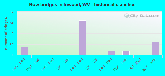
- New bridges - historical statistics
- 21920-1929
- 81960-1969
- 11980-1989
- 11990-1999
- 32010-2019


- Bridge Condition - Deck
- 20.0%Good
- 30.0%Satisfactory
- 40.0%Fair
- 10.0%Serious

- Bridge Condition - Superstructure
- 20.0%Good
- 40.0%Satisfactory
- 30.0%Fair
- 10.0%Poor

- Bridge Condition - Substructure
- 10.0%Good
- 50.0%Satisfactory
- 30.0%Fair
- 10.0%Poor

- Bridge Condition - Channel
- 62.5%Good
- 37.5%Satisfactory
Find on map >> Show street view
Structure Number: 2A044, Location: 0.02 MI N OF CR 11/8 SLS (Lat: 39.371411, Lng: -78.027300), Route carried "on" structure: US 1100, Year Built: 1928, Status: Open, Structure Length: 0.94m (3.08ft), Average Daily Traffic: 8,400 (year 2019), Truck Traffic: 4%, Average Future Daily Traffic: 9,492 (year 2039), Features Intersected: MIDDLE CREEK, Facility Carried by Structure: US 11 SLS
Minimum Vertical Clearance: 30+ m (98+ ft), Kilometerpoint: 9.737, Lanes on structure: 2, Owner: State Highway Agency, Approaching Roadway Width: 8.5m (27.9ft), Material/Design: Concrete, Design/Construction: Slab, Number Of Spans In Main Unit: 2, Length of Maximum Span: 4.3m (14.1ft), Curb-To-Curb Width: 9.0m (29.5ft), Out-to-Out Width: 9.1m (29.9ft)
Condition: Deck: Satisfactory, Superstructure: Satisfactory, Substructure: Satisfactory, Channel: Satisfactory, Operating Rating: 53.5 metric tons, Method Used To Determine Operating Rating: Field evaluation and documented engineering judgment, Inventory Rating: 24.5 metric tons, Method Used To Determine Inventory Rating: Field evaluation and documented engineering judgment, Structural Evaluation: Equal to present minimum criteria, Deck Geometry: High priority of replacement, Waterway Adequacy: Equal to present minimum criteria, Approach Roadway Alignment: Better than present minimum criteria, Designated Inspection Frequency: Every 24 months, Inspection Date: April 2021, Deck Structure Type: Concrete Cast-file-Place, Wearing Surface/Protective System: Wearing Surface: Bituminous
Find on map >> Show street view
Structure Number: 2A065, Location: 0.04 MI E OF CR 81/2 SLS (Lat: 39.314881, Lng: -78.075781), Route carried "on" structure: County highway 2401, Year Built: 1966, Status: Open, Structure Length: 8.21m (26.94ft), Average Daily Traffic: 1,037 (year 2016), Truck Traffic: 2%, Average Future Daily Traffic: 1,421 (year 2036), Design Load: HS 20, Features Intersected: I 81 (X), Facility Carried by Structure: CR. 24/1 SLS
Minimum Vertical Clearance: 30+ m (98+ ft), Kilometerpoint: 2.591, Lanes on structure: 2, Lanes under structure: 4, Owner: State Highway Agency, Approaching Roadway Width: 8.5m (27.9ft), Material/Design: Prestressed concrete, Design/Construction: Stringer/Multi-beam, Number Of Spans In Main Unit: 2, Number Of Approach Spans: 2, Length of Maximum Span: 24.1m (79.1ft), Curb or Sidewalk Widths: Left: 0.4m (1.3ft), Right: 0.4m (1.3ft), Curb-To-Curb Width: 7.3m (24.0ft), Out-to-Out Width: 8.8m (28.9ft)
Condition: Deck: Satisfactory, Superstructure: Satisfactory, Substructure: Good, Operating Rating: 67.1 metric tons, Method Used To Determine Operating Rating: Load Factor (LF), Inventory Rating: 40.8 metric tons, Method Used To Determine Inventory Rating: Load Factor (LF), Structural Evaluation: Equal to present minimum criteria, Deck Geometry: Meets minimum limits, Underclear: Equal to present minimum criteria, Approach Roadway Alignment: Better than present minimum criteria, Designated Inspection Frequency: Every 48 months, Inspection Date: August 2018, Deck Structure Type: Concrete Cast-file-Place
Find on map >> Show street view
Structure Number: 2A066, Location: 0.34 MI W OF CR 51/5 (Lat: 39.345489, Lng: -78.067350), Route carried "on" structure: County highway 2403, Year Built: 1926, Status: Posted for load, Structure Length: 0.98m (3.22ft), Average Daily Traffic: 80 (year 2020), Truck Traffic: 2%, Average Future Daily Traffic: 134 (year 2040), Features Intersected: MILL CREEK, Facility Carried by Structure: CR 24/3 SLS
Minimum Vertical Clearance: 30+ m (98+ ft), Kilometerpoint: 1.690, Lanes on structure: 1, Owner: State Highway Agency, Approaching Roadway Width: 4.0m (13.1ft), Skew: 2 degrees, Material/Design: Concrete, Design/Construction: Slab, Number Of Spans In Main Unit: 1, Length of Maximum Span: 9.1m (29.9ft), Curb-To-Curb Width: 4.1m (13.5ft), Out-to-Out Width: 4.8m (15.7ft)
Condition: Deck: Fair, Superstructure: Fair, Substructure: Poor, Channel: Satisfactory, Operating Rating: 41.7 metric tons, Method Used To Determine Operating Rating: Field evaluation and documented engineering judgment, Inventory Rating: 19.0 metric tons, Method Used To Determine Inventory Rating: Field evaluation and documented engineering judgment, Structural Evaluation: Meets minimum limits, Deck Geometry: Somewhat better than minimum adequacy, Waterway Adequacy: Equal to present minimum criteria, Approach Roadway Alignment: Better than present minimum criteria, Length Of Structure Improvement: 3.05m (10.01ft), Designated Inspection Frequency: Every 24 months, Inspection Date: June 2021, Bridge Improvement Cost: $500,000, Roadway Improvement Cost: $200,000, Total Project Cost: $700,000 ( Estimate for 2025), Deck Structure Type: Concrete Cast-file-Place, Wearing Surface/Protective System: Wearing Surface: Bituminous
Find on map >> Show street view
Structure Number: 2A067, Location: 0.69 MI W OF US 11 SLS (Lat: 39.332361, Lng: -78.065939), Route carried "on" structure: County highway 2600, Year Built: 1965, Status: Open, Structure Length: 6.84m (22.44ft), Average Daily Traffic: 2,400 (year 2018), Truck Traffic: 2%, Average Future Daily Traffic: 3,000 (year 2038), Design Load: HS 20, Features Intersected: I-81 (X), Facility Carried by Structure: CR 26 SLS
Minimum Vertical Clearance: 30+ m (98+ ft), Kilometerpoint: 5.552, Lanes on structure: 2, Lanes under structure: 4, Owner: State Highway Agency, Approaching Roadway Width: 7.6m (24.9ft), Material/Design: Prestressed concrete, Design/Construction: Stringer/Multi-beam, Number Of Spans In Main Unit: 2, Number Of Approach Spans: 2, Length of Maximum Span: 21.4m (70.2ft), Curb or Sidewalk Widths: Left: 0.4m (1.3ft), Right: 0.4m (1.3ft), Curb-To-Curb Width: 7.3m (24.0ft), Out-to-Out Width: 8.8m (28.9ft)
Condition: Deck: Fair, Superstructure: Fair, Substructure: Fair, Operating Rating: 80.7 metric tons, Method Used To Determine Operating Rating: Load Factor (LF), Inventory Rating: 48.1 metric tons, Method Used To Determine Inventory Rating: Load Factor (LF), Structural Evaluation: Somewhat better than minimum adequacy, Deck Geometry: High priority of replacement, Underclear: Somewhat better than minimum adequacy, Approach Roadway Alignment: Better than present minimum criteria, Length Of Structure Improvement: 6.86m (22.51ft), Designated Inspection Frequency: Every 24 months, Inspection Date: July 2020, Bridge Improvement Cost: $2,400,000, Roadway Improvement Cost: $100,000, Total Project Cost: $2,500,000 ( Estimate for 2020), Deck Structure Type: Concrete Cast-file-Place
Find on map >> Show street view
Structure Number: 2A068, Location: 0.27 MI. E. OF CR 51/6 (Lat: 39.329261, Lng: -78.040600), Route carried "on" structure: County highway 2600, Year Built: 1987, Status: Posted for load, Structure Length: 1.15m (3.77ft), Average Daily Traffic: 3,000 (year 2020), Truck Traffic: 2%, Average Future Daily Traffic: 5,010 (year 2040), Design Load: HS 20, Features Intersected: MILL CREEK, Facility Carried by Structure: CR 26 SLS
Minimum Vertical Clearance: 30+ m (98+ ft), Kilometerpoint: 8.111, Lanes on structure: 2, Owner: State Highway Agency, Approaching Roadway Width: 7.6m (24.9ft), Material/Design: Steel, Design/Construction: Stringer/Multi-beam, Number Of Spans In Main Unit: 1, Length of Maximum Span: 10.4m (34.1ft), Curb-To-Curb Width: 5.5m (18.0ft), Out-to-Out Width: 5.5m (18.0ft)
Condition: Deck: Fair, Superstructure: Poor, Substructure: Satisfactory, Channel: Good, Operating Rating: 28.1 metric tons, Method Used To Determine Operating Rating: Load Factor (LF), Inventory Rating: 17.2 metric tons, Method Used To Determine Inventory Rating: Load Factor (LF), Structural Evaluation: Meets minimum limits, Deck Geometry: High priority of replacement, Waterway Adequacy: Equal to present desirable criteria, Approach Roadway Alignment: Somewhat better than minimum adequacy, Bridge Posting: Required (Relationship of Operating Rating to Maximum Legal Load: 10.0 - 19.9% below), Length Of Structure Improvement: 1.16m (3.81ft), Designated Inspection Frequency: Every 24 months, Inspection Date: December 2021, Bridge Improvement Cost: $60,000, Roadway Improvement Cost: $5,000, Total Project Cost: $65,000 ( Estimate for 2015), Deck Structure Type: Wood or Timber, Wearing Surface/Protective System: Wearing Surface: Bituminous
Find on map >> Show street view
Structure Number: 2A078, Location: 0.09 MI E OF CR 30 SLS (Lat: 39.362531, Lng: -78.048181), Route carried "on" structure: State highway 5100, Year Built: 1965, Status: Open, Structure Length: 6.77m (22.21ft), Average Daily Traffic: 22,800 (year 2019), Truck Traffic: 5%, Average Future Daily Traffic: 28,500 (year 2039), Design Load: HS 20, Features Intersected: I81(X), Facility Carried by Structure: WV 51 F
Minimum Vertical Clearance: 30+ m (98+ ft), Kilometerpoint: 7.371, Lanes on structure: 2, Lanes under structure: 4, Owner: State Highway Agency, Approaching Roadway Width: 13.7m (44.9ft), Skew: 1 degrees, Material/Design: Prestressed concrete, Design/Construction: Stringer/Multi-beam, Number Of Spans In Main Unit: 2, Number Of Approach Spans: 2, Length of Maximum Span: 21.6m (70.9ft), Curb or Sidewalk Widths: Left: 0.9m (3.0ft), Right: 0.9m (3.0ft), Curb-To-Curb Width: 8.6m (28.2ft), Out-to-Out Width: 11.0m (36.1ft)
Condition: Deck: Fair, Superstructure: Fair, Substructure: Fair, Operating Rating: 56.2 metric tons, Method Used To Determine Operating Rating: Load Factor (LF), Inventory Rating: 34.5 metric tons, Method Used To Determine Inventory Rating: Load Factor (LF), Structural Evaluation: Somewhat better than minimum adequacy, Deck Geometry: Meets minimum limits, Underclear: Somewhat better than minimum adequacy, Approach Roadway Alignment: Better than present minimum criteria, Length Of Structure Improvement: 6.77m (22.21ft), Designated Inspection Frequency: Every 24 months, Inspection Date: October 2020, Bridge Improvement Cost: $5,000,000, Roadway Improvement Cost: $1,500,000, Total Project Cost: $6,500,000 ( Estimate for 2016), Deck Structure Type: Concrete Cast-file-Place
Find on map >> Show street view
Structure Number: 2A08, Location: 0.45 MI S OF WV. 51 SLS (Lat: 39.366031, Lng: -78.100900), Route carried "on" structure: County highway 5102, Year Built: 1992, Status: Open, Structure Length: 1.40m (4.59ft), Average Daily Traffic: 1,200 (year 2018), Truck Traffic: 2%, Average Future Daily Traffic: 1,500 (year 2038), Design Load: HS 25 or greater, Features Intersected: BRANCH OF MILL CRK., Facility Carried by Structure: CR 51/2 SLS
Minimum Vertical Clearance: 30+ m (98+ ft), Kilometerpoint: 5.327, Lanes on structure: 2, Owner: State Highway Agency, Approaching Roadway Width: 7.3m (24.0ft), Skew: 3 degrees, Material/Design: Prestressed concrete, Design/Construction: Box Beam or Girders - Multiple, Number Of Spans In Main Unit: 1, Length of Maximum Span: 12.7m (41.7ft), Curb-To-Curb Width: 8.0m (26.2ft), Out-to-Out Width: 8.3m (27.2ft)
Condition: Deck: Satisfactory, Superstructure: Satisfactory, Substructure: Satisfactory, Channel: Satisfactory, Operating Rating: 48.1 metric tons, Method Used To Determine Operating Rating: Load Factor (LF), Inventory Rating: 29.0 metric tons, Method Used To Determine Inventory Rating: Load Factor (LF), Structural Evaluation: Equal to present minimum criteria, Deck Geometry: Meets minimum limits, Waterway Adequacy: Somewhat better than minimum adequacy, Approach Roadway Alignment: Equal to present minimum criteria, Designated Inspection Frequency: Every 48 months, Inspection Date: March 2020, Deck Structure Type: Other, Wearing Surface/Protective System: Wearing Surface: Bituminous, Deck Protection: Epoxy Coated Reinforcing
Find on map >> Show street view
Structure Number: 2A1, Location: 1.72 MI S OF WV 51 SLS (Lat: 39.340239, Lng: -78.061981), Route carried "on" structure: Interstate 8100, Year Built: 1965, Status: Open, Structure Length: 2.06m (6.76ft), Average Daily Traffic: 29,200 (year 2019), Truck Traffic: 32%, Average Future Daily Traffic: 40,296 (year 2039), Design Load: HS 20+Mod, Features Intersected: CR 51/5 and Mill Creek, Facility Carried by Structure: I 81 X
Minimum Vertical Clearance: 30+ m (98+ ft), Kilometerpoint: 5.295, Lanes on structure: 2, Lanes under structure: 2, Base Highway Network: Yes, Owner: State Highway Agency, Approaching Roadway Width: 11.3m (37.1ft), Material/Design: Prestressed concrete, Design/Construction: Stringer/Multi-beam, Number Of Spans In Main Unit: 1, Length of Maximum Span: 18.9m (62.0ft), Curb-To-Curb Width: 11.2m (36.7ft), Out-to-Out Width: 12.3m (40.4ft)
Condition: Deck: Serious, Superstructure: Satisfactory, Substructure: Fair, Channel: Good, Operating Rating: 61.7 metric tons, Method Used To Determine Operating Rating: Load Factor (LF), Inventory Rating: 38.1 metric tons, Method Used To Determine Inventory Rating: Load Factor (LF), Structural Evaluation: Somewhat better than minimum adequacy, Deck Geometry: Somewhat better than minimum adequacy, Underclear: High priority of corrective action, Waterway Adequacy: Superior to present desirable criteria, Approach Roadway Alignment: Equal to present desirable criteria, Length Of Structure Improvement: 2.13m (6.99ft), Designated Inspection Frequency: Every 24 months, Other Special Inspection Frequency: Every 12 months, Inspection Date: April 2021, Other Special Inspection Date: April 2021, Bridge Improvement Cost: $1,750,000, Roadway Improvement Cost: $250,000, Total Project Cost: $2,000,000 ( Estimate for 2019), Deck Structure Type: Concrete Cast-file-Place, Wearing Surface/Protective System: Wearing Surface: Bituminous
Find on map >> Show street view
Structure Number: 2A153, Location: 0.12 Mile South of WV 51 (Lat: 39.369500, Lng: -78.097350), Route carried "on" structure: County highway 5102, Year Built: 2011, Status: Open, Structure Length: 0.78m (2.56ft), Average Daily Traffic: 1,200 (year 2019), Truck Traffic: 2%, Average Future Daily Traffic: 1,500 (year 2039), Design Load: HL 93, Features Intersected: Branch of Mill Creek, Facility Carried by Structure: CR 51/2 (SLS)
Minimum Vertical Clearance: 30+ m (98+ ft), Kilometerpoint: 5.858, Lanes on structure: 2, Owner: State Highway Agency, Approaching Roadway Width: 6.7m (22.0ft), Material/Design: Concrete, Design/Construction: Culvert, Number Of Spans In Main Unit: 1, Length of Maximum Span: 7.3m (24.0ft), Curb or Sidewalk Widths: Left: 1.4m (4.6ft), Right: 1.4m (4.6ft), Curb-To-Curb Width: 7.3m (24.0ft), Out-to-Out Width: 12.8m (42.0ft)
Condition: Channel: Good, Culverts: Good, Operating Rating: 88.9 metric tons, Method Used To Determine Operating Rating: Field evaluation and documented engineering judgment, Inventory Rating: 40.8 metric tons, Method Used To Determine Inventory Rating: Field evaluation and documented engineering judgment, Structural Evaluation: Better than present minimum criteria, Deck Geometry: Meets minimum limits, Waterway Adequacy: Superior to present desirable criteria, Approach Roadway Alignment: Equal to present desirable criteria, Designated Inspection Frequency: Every 48 months, Inspection Date: May 2021
Find on map >> Show street view
Structure Number: 2A169, Location: 0.02 mi south of WV 51 (Lat: 39.365531, Lng: -78.078211), Route carried "on" structure: County highway 24, Year Built: 2014, Status: Open, Structure Length: 0.92m (3.02ft), Average Daily Traffic: 1,500 (year 2019), Truck Traffic: 2%, Average Future Daily Traffic: 1,875 (year 2039), Design Load: HL 93, Features Intersected: Mill Creek
Minimum Vertical Clearance: 30+ m (98+ ft), Kilometerpoint: 6.775, Lanes on structure: 2, Owner: State Highway Agency, Approaching Roadway Width: 6.7m (22.0ft), Skew: 1 degrees, Material/Design: Concrete, Design/Construction: Slab, Number Of Spans In Main Unit: 1, Length of Maximum Span: 9.2m (30.2ft), Curb-To-Curb Width: 7.6m (24.9ft), Out-to-Out Width: 7.8m (25.6ft)
Condition: Deck: Good, Superstructure: Good, Substructure: Satisfactory, Channel: Good, Operating Rating: 56.2 metric tons, Method Used To Determine Operating Rating: Load and Resistance Factor (LRFR), Inventory Rating: 43.5 metric tons, Method Used To Determine Inventory Rating: Load and Resistance Factor (LRFR), Structural Evaluation: Equal to present minimum criteria, Deck Geometry: Meets minimum limits, Waterway Adequacy: Better than present minimum criteria, Approach Roadway Alignment: Better than present minimum criteria, Designated Inspection Frequency: Every 48 months, Inspection Date: December 2020, Deck Structure Type: Concrete Cast-file-Place
Find on map >> Show street view
Structure Number: 2A17, Location: 0.01 miles east of CR 24 (Lat: 39.407269, Lng: -78.059469), Route carried "on" structure: County highway 37, Year Built: 2014, Status: Open, Structure Length: 0.91m (2.99ft), Average Daily Traffic: 1,000 (year 2019), Truck Traffic: 2%, Average Future Daily Traffic: 1,250 (year 2039), Design Load: HL 93, Features Intersected: Middle Creek
Minimum Vertical Clearance: 30+ m (98+ ft), Kilometerpoint: 3.798, Lanes on structure: 2, Owner: State Highway Agency, Approaching Roadway Width: 6.4m (21.0ft), Material/Design: Concrete, Design/Construction: Slab, Number Of Spans In Main Unit: 1, Length of Maximum Span: 9.1m (29.9ft), Curb-To-Curb Width: 8.4m (27.6ft), Out-to-Out Width: 8.5m (27.9ft)
Condition: Deck: Good, Superstructure: Good, Substructure: Satisfactory, Channel: Good, Operating Rating: 73.5 metric tons, Method Used To Determine Operating Rating: Load and Resistance Factor (LRFR), Inventory Rating: 57.1 metric tons, Method Used To Determine Inventory Rating: Load and Resistance Factor (LRFR), Structural Evaluation: Equal to present minimum criteria, Deck Geometry: Somewhat better than minimum adequacy, Waterway Adequacy: Equal to present minimum criteria, Approach Roadway Alignment: Equal to present minimum criteria, Designated Inspection Frequency: Every 48 months, Inspection Date: December 2020, Deck Structure Type: Concrete Cast-file-Place
Find on map >> Show street view
Structure Number: 2A065, Location: 0.04 MI E OF CR 81/2 SLS (Lat: 39.314881, Lng: -78.075781), Route carried "under" structure: Interstate 8100, Year Built: 1966, Structure Length: 0. m, Average Daily Traffic: 53,650 (year 2016), Truck Traffic: 16%, Features Intersected: I 81 (X), Facility Carried by Structure: CR. 24/1 SLS
Minimum Vertical Clearance: 5.18m (16.99ft), Kilometerpoint: 2.237, Lanes on structure: 2, Lanes under structure: 4, Length of Maximum Span: 24.1m (79.1ft)
Find on map >> Show street view
Structure Number: 2A067, Location: 0.69 MI W OF US 11 SLS (Lat: 39.332369, Lng: -78.065989), Route carried "under" structure: Interstate 8100, Year Built: 1965, Structure Length: 0. m, Average Daily Traffic: 55,000 (year 2018), Truck Traffic: 32%, Features Intersected: I-81 (X), Facility Carried by Structure: CR 26 SLS
Minimum Vertical Clearance: 5.74m (18.83ft), Kilometerpoint: 4.361, Lanes on structure: 2, Lanes under structure: 4, Length of Maximum Span: 21.4m (70.2ft)
Find on map >> Show street view
Structure Number: 2A078, Location: 0.09 MI E OF CR 30 SLS (Lat: 39.362531, Lng: -78.048181), Route carried "under" structure: Interstate 8100, Year Built: 1965, Structure Length: 0. m, Average Daily Traffic: 58,400 (year 2019), Truck Traffic: 32%, Features Intersected: I81(X), Facility Carried by Structure: WV 51 F
Minimum Vertical Clearance: 5.13m (16.83ft), Kilometerpoint: 8.063, Lanes on structure: 2, Lanes under structure: 4, Length of Maximum Span: 21.6m (70.9ft)
Find on map >> Show street view
Structure Number: 2A1, Location: 1.72 MI S OF WV 51 SLS (Lat: 39.340239, Lng: -78.061981), Route carried "under" structure: County highway 5105, Year Built: 1965, Structure Length: 0. m, Average Daily Traffic: 2,100 (year 2019), Truck Traffic: 2%, Features Intersected: CR 51/5 and Mill Creek, Facility Carried by Structure: I 81 X
Minimum Vertical Clearance: 4.32m (14.17ft), Kilometerpoint: 0.982, Lanes on structure: 2, Lanes under structure: 2, Length of Maximum Span: 18.9m (62.0ft)