Bridge Statistics for Inwood, Florida (FL)
Condition, Traffic, Stress, Structural Evaluation, Project Costs
- National Bridge Inventory (NBI) Statistics
- 18Number of bridges
- 466ft / 142mTotal length
- $288,000Total costs
- 147,315Total average daily traffic
- 14,471Total average daily truck traffic
- 244,924Total future (year 2041) average daily traffic
- National Bridge Inventory (NBI) Registered Bridges for Inwood
- No street view available for this location
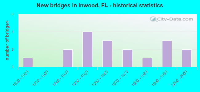
- New bridges - historical statistics
- 11920-1929
- 21940-1949
- 41950-1959
- 31960-1969
- 21970-1979
- 11980-1989
- 31990-1999
- 22000-2009
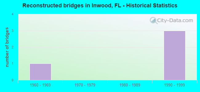
- Reconstructed bridges - Historical Statistics
- 11960-1969
- 01970-1979
- 01980-1989
- 31990-1999
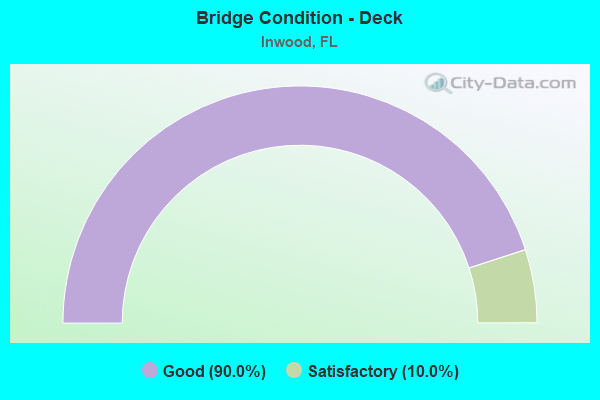
- Bridge Condition - Deck
- 90.0%Good
- 10.0%Satisfactory
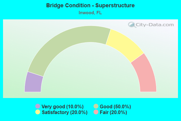
- Bridge Condition - Superstructure
- 10.0%Very good
- 50.0%Good
- 20.0%Satisfactory
- 20.0%Fair
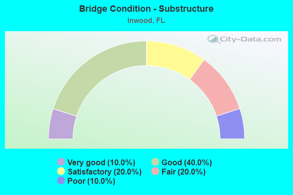
- Bridge Condition - Substructure
- 10.0%Very good
- 40.0%Good
- 20.0%Satisfactory
- 20.0%Fair
- 10.0%Poor
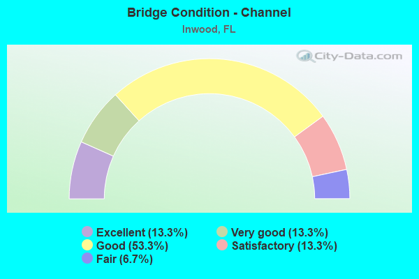
- Bridge Condition - Channel
- 13.3%Excellent
- 13.3%Very good
- 53.3%Good
- 13.3%Satisfactory
- 6.7%Fair
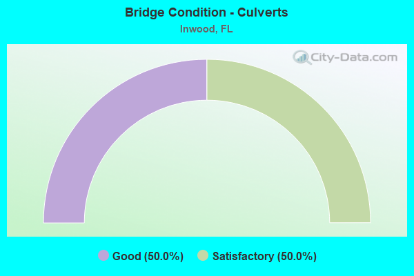
- Bridge Condition - Culverts
- 50.0%Good
- 50.0%Satisfactory
Find on map >> Show street view
Structure Number: 5094, Location: 0.5MI SOUTH OF SR-17 (Lat: 27.026522, Lng: -81.340756), Route carried "on" structure: US 27, Year Built: 1957, Year Reconstructed: 1973, Status: Open, Structure Length: 0.66m (2.17ft), Average Daily Traffic: 6,600 (year 2022), Truck Traffic: 36%, Average Future Daily Traffic: 11,451 (year 2042), Design Load: H 15, Features Intersected: GOPHER GULLY RUN
Minimum Vertical Clearance: 30+ m (98+ ft), Kilometerpoint: 45.873, Lanes on structure: 5, Base Highway Network: Yes, Owner: State Highway Agency, Approaching Roadway Width: 20.4m (66.9ft), Skew: 10 degrees, Material/Design: Concrete, Design/Construction: Culvert, Number Of Spans In Main Unit: 2, Length of Maximum Span: 3.3m (10.8ft)
Condition: Channel: Good, Culverts: Satisfactory, Operating Rating: 63.3 metric tons, Method Used To Determine Operating Rating: Load Factor (LF), Inventory Rating: 37.9 metric tons, Method Used To Determine Inventory Rating: Load Factor (LF), Structural Evaluation: Equal to present minimum criteria, Waterway Adequacy: Equal to present desirable criteria, Approach Roadway Alignment: Equal to present desirable criteria, Designated Inspection Frequency: Every 24 months, Inspection Date: Febuary 2022
Find on map >> Show street view
Structure Number: 105605, Location: BAYSHORE BLVD;HYDE PK AV (Lat: 27.937592, Lng: -82.463514), Route carried "on" structure: City street , Year Built: 1966, Status: Open, Structure Length: 40.52m (132.94ft), Average Daily Traffic: 7,300 (year 2020), Truck Traffic: 9%, Average Future Daily Traffic: 12,666 (year 2042), Features Intersected: HILLS. BAY & BAYSHORE B., Facility Carried by Structure: DAVIS ISLD BRIDGE
Minimum Vertical Clearance: 4.79m (15.72ft), Kilometerpoint: 0.806, Lanes on structure: 2, Lanes under structure: 6, Owner: City or Municipal Highway Agency, Approaching Roadway Width: 7.5m (24.6ft), Skew: 9 degrees, Material/Design: Prestressed concrete, Design/Construction: Stringer/Multi-beam, Number Of Spans In Main Unit: 21, Length of Maximum Span: 20.4m (66.9ft), Curb or Sidewalk Widths: Left: 0.6m (2.0ft), Right: 0.6m (2.0ft), Curb-To-Curb Width: 7.3m (24.0ft), Out-to-Out Width: 9.2m (30.2ft)
Condition: Deck: Good, Superstructure: Fair, Substructure: Satisfactory, Channel: Very good, Operating Rating: 48.8 metric tons, Method Used To Determine Operating Rating: Load Factor (LF), Inventory Rating: 43.5 metric tons, Method Used To Determine Inventory Rating: Load Factor (LF), Structural Evaluation: Somewhat better than minimum adequacy, Deck Geometry: High priority of replacement, Underclear: Meets minimum limits, Waterway Adequacy: Superior to present desirable criteria, Approach Roadway Alignment: Equal to present minimum criteria, Designated Inspection Frequency: Every 24 months, Underwater Inspection Frequency: Every 24 months, Inspection Date: Febuary 2021, Underwater Inspection Date: January 2021, Deck Structure Type: Concrete Cast-file-Place
Find on map >> Show street view
Structure Number: 105606, Location: BRIDGE OFF DAVIS ISLAND (Lat: 27.937831, Lng: -82.461317), Route carried "on" structure: City street , Year Built: 1927, Year Reconstructed: 1990, Status: Open, Structure Length: 19.38m (63.58ft), Average Daily Traffic: 2,900 (year 2020), Truck Traffic: 9%, Average Future Daily Traffic: 5,032 (year 2042), Design Load: HL 93, Features Intersected: HILLS. BAY & BAYSHORE B., Facility Carried by Structure: PLANT AVENUE
Minimum Vertical Clearance: 5.27m (17.29ft), Kilometerpoint: 3.592, Lanes on structure: 3, Lanes under structure: 5, Owner: City or Municipal Highway Agency, Approaching Roadway Width: 7.3m (24.0ft), Skew: 39 degrees, Navigation Control: Yes ( Vertical Clearance: 2.9m (9.5ft), Horizontal Clearance: 10.6m (34.8ft)), Material/Design: Prestressed concrete, Design/Construction: Stringer/Multi-beam, Number Of Spans In Main Unit: 8, Number Of Approach Spans: 6, Length of Maximum Span: 22.1m (72.5ft), Curb or Sidewalk Widths: Left: 2.2m (7.2ft), Right: 2.1m (6.9ft), Curb-To-Curb Width: 7.3m (24.0ft), Out-to-Out Width: 9.3m (30.5ft)
Condition: Deck: Satisfactory, Superstructure: Fair, Substructure: Satisfactory, Channel: Excellent, Operating Rating: 38.8 metric tons, Method Used To Determine Operating Rating: Load and Resistance Factor (LRFR), Inventory Rating: 30.0 metric tons, Method Used To Determine Inventory Rating: Load and Resistance Factor (LRFR), Structural Evaluation: Somewhat better than minimum adequacy, Deck Geometry: High priority of replacement, Underclear: Meets minimum limits, Waterway Adequacy: Superior to present desirable criteria, Approach Roadway Alignment: Better than present minimum criteria, Length Of Structure Improvement: 18.60m (61.02ft), Designated Inspection Frequency: Every 24 months, Underwater Inspection Frequency: Every 24 months, Inspection Date: Febuary 2021, Underwater Inspection Date: January 2021, Bridge Improvement Cost: $262,000, Roadway Improvement Cost: $26,000, Total Project Cost: $288,000, Deck Structure Type: Concrete Cast-file-Place
Find on map >> Show street view
Structure Number: 105911, Location: 328ft S OF SAN RAFAEL (Lat: 27.926039, Lng: -82.524375), Route carried "on" structure: City street 587, Year Built: 1979, Status: Open, Structure Length: 0.82m (2.69ft), Average Daily Traffic: 22,000 (year 2021), Truck Traffic: 5%, Average Future Daily Traffic: 27,500 (year 2041), Design Load: HS 20, Features Intersected: CEDAR CANAL
Minimum Vertical Clearance: 30+ m (98+ ft), Kilometerpoint: 0.000, Lanes on structure: 2, Owner: County Highway Agency, Approaching Roadway Width: 7.0m (23.0ft), Skew: 4 degrees, Material/Design: Concrete, Design/Construction: Culvert, Number Of Spans In Main Unit: 2, Length of Maximum Span: 3.7m (12.1ft)
Condition: Channel: Good, Culverts: Satisfactory, Operating Rating: 66.4 metric tons, Method Used To Determine Operating Rating: Load Factor (LF), Inventory Rating: 39.8 metric tons, Method Used To Determine Inventory Rating: Load Factor (LF), Structural Evaluation: Equal to present minimum criteria, Waterway Adequacy: Equal to present minimum criteria, Approach Roadway Alignment: Equal to present desirable criteria, Designated Inspection Frequency: Every 24 months, Underwater Inspection Frequency: Every 24 months, Inspection Date: October 2021, Underwater Inspection Date: September 2021
Find on map >> Show street view
Structure Number: 105912, Location: 0.2MI S OF HILLSBOROUGH A (Lat: 27.992419, Lng: -82.501053), Route carried "on" structure: City street , Year Built: 1975, Status: Open, Structure Length: 0.63m (2.07ft), Average Daily Traffic: 2,700 (year 2020), Truck Traffic: 9%, Average Future Daily Traffic: 4,685 (year 2042), Features Intersected: RUSTY CANAL, Facility Carried by Structure: HIMES AVE.
Minimum Vertical Clearance: 30+ m (98+ ft), Kilometerpoint: 13.036, Lanes on structure: 4, Owner: City or Municipal Highway Agency, Approaching Roadway Width: 17.2m (56.4ft), Skew: 20 degrees, Material/Design: Concrete, Design/Construction: Culvert, Number Of Spans In Main Unit: 2, Length of Maximum Span: 3.0m (9.8ft)
Condition: Channel: Fair, Culverts: Satisfactory, Operating Rating: 54.7 metric tons, Method Used To Determine Operating Rating: Load Factor (LF), Inventory Rating: 32.8 metric tons, Method Used To Determine Inventory Rating: Load Factor (LF), Structural Evaluation: Equal to present minimum criteria, Waterway Adequacy: Superior to present desirable criteria, Approach Roadway Alignment: Equal to present desirable criteria, Designated Inspection Frequency: Every 24 months, Inspection Date: Febuary 2021
Find on map >> Show street view
Structure Number: 105913, Location: IN JULIAN B. LANE PARK (Lat: 27.952025, Lng: -82.465994), Route carried "on" structure: City street , Year Built: 1968, Status: Open, Structure Length: 1.00m (3.28ft), Average Daily Traffic: 101 (year 2020), Truck Traffic: 1%, Average Future Daily Traffic: 175 (year 2042), Design Load: H 15, Features Intersected: DRAINAGE CANAL, Facility Carried by Structure: CYPRESS ST.
Minimum Vertical Clearance: 30+ m (98+ ft), Kilometerpoint: 0.000, Lanes on structure: 2, Owner: City or Municipal Highway Agency, Approaching Roadway Width: 18.0m (59.1ft), Material/Design: Concrete, Design/Construction: Culvert, Number Of Spans In Main Unit: 3, Length of Maximum Span: 4.2m (13.8ft)
Condition: Channel: Excellent, Culverts: Good, Operating Rating: 52.1 metric tons, Method Used To Determine Operating Rating: Load Factor (LF), Inventory Rating: 31.4 metric tons, Method Used To Determine Inventory Rating: Load Factor (LF), Structural Evaluation: Better than present minimum criteria, Waterway Adequacy: Better than present minimum criteria, Approach Roadway Alignment: Equal to present desirable criteria, Designated Inspection Frequency: Every 24 months, Underwater Inspection Frequency: Every 24 months, Inspection Date: Febuary 2021, Underwater Inspection Date: January 2021
Find on map >> Show street view
Structure Number: 105915, Location: 0.4 MILE WEST OF CR-581 (Lat: 28.145392, Lng: -82.361714), Route carried "on" structure: City street , Year Built: 1996, Status: Open, Structure Length: 4.02m (13.19ft), Average Daily Traffic: 9,500 (year 2020), Truck Traffic: 13%, Average Future Daily Traffic: 16,483 (year 2042), Design Load: HS 20, Features Intersected: TROUT CREEK, Facility Carried by Structure: NEW TAMPA BLVD.
Minimum Vertical Clearance: 30+ m (98+ ft), Kilometerpoint: 5.403, Lanes on structure: 2, Owner: City or Municipal Highway Agency, Approaching Roadway Width: 7.2m (23.6ft), Material/Design: Prestressed concrete, Design/Construction: Slab, Number Of Spans In Main Unit: 4, Length of Maximum Span: 10.4m (34.1ft), Curb or Sidewalk Widths: Left: 1.6m (5.2ft), Right: 0.0m, Curb-To-Curb Width: 8.5m (27.9ft), Out-to-Out Width: 11.2m (36.7ft)
Condition: Deck: Good, Superstructure: Good, Substructure: Good, Channel: Good, Operating Rating: 69.5 metric tons, Method Used To Determine Operating Rating: Load Factor (LF), Inventory Rating: 41.7 metric tons, Method Used To Determine Inventory Rating: Load Factor (LF), Structural Evaluation: Better than present minimum criteria, Deck Geometry: High priority of replacement, Waterway Adequacy: Superior to present desirable criteria, Approach Roadway Alignment: Equal to present desirable criteria, Designated Inspection Frequency: Every 24 months, Inspection Date: Febuary 2021, Deck Structure Type: Concrete Precast Panels, Wearing Surface/Protective System: Wearing Surface: Integral Concrete
Find on map >> Show street view
Structure Number: 330004, Location: 0.6 MI SOUTH OF CR 534 (Lat: 30.076889, Lng: -83.240139), Route carried "on" structure: County highway 251, Year Built: 1955, Status: Open, Structure Length: 0.86m (2.82ft), Average Daily Traffic: 200 (year 2020), Truck Traffic: 10%, Average Future Daily Traffic: 347 (year 2042), Features Intersected: CATTLE CROSSING, Facility Carried by Structure: SW CR 300
Minimum Vertical Clearance: 30+ m (98+ ft), Kilometerpoint: 0.978, Lanes on structure: 2, Owner: County Highway Agency, Approaching Roadway Width: 5.9m (19.4ft), Material/Design: Concrete, Design/Construction: Culvert, Number Of Spans In Main Unit: 3, Length of Maximum Span: 3.0m (9.8ft)
Condition: Channel: Very good, Culverts: Good, Operating Rating: 54.5 metric tons, Method Used To Determine Operating Rating: Load and Resistance Factor (LRFR), Inventory Rating: 34.9 metric tons, Method Used To Determine Inventory Rating: Load and Resistance Factor (LRFR), Structural Evaluation: Better than present minimum criteria, Waterway Adequacy: Equal to present desirable criteria, Approach Roadway Alignment: Equal to present minimum criteria, Designated Inspection Frequency: Every 24 months, Inspection Date: April 2020
Find on map >> Show street view
Structure Number: 330005, Location: 0.4 MI NORTH OF CR 250 (Lat: 30.252611, Lng: -83.266389), Route carried "on" structure: County highway 251, Year Built: 1969, Status: Posted for load, Structure Length: 4.27m (14.01ft), Average Daily Traffic: 151 (year 2020), Truck Traffic: 5%, Average Future Daily Traffic: 262 (year 2042), Features Intersected: MILL CREEK
Minimum Vertical Clearance: 30+ m (98+ ft), Kilometerpoint: 0.708, Lanes on structure: 2, Owner: County Highway Agency, Approaching Roadway Width: 6.0m (19.7ft), Material/Design: Concrete, Design/Construction: Slab, Number Of Spans In Main Unit: 5, Length of Maximum Span: 8.5m (27.9ft), Curb-To-Curb Width: 9.8m (32.2ft), Out-to-Out Width: 10.4m (34.1ft)
Condition: Deck: Good, Superstructure: Good, Substructure: Fair, Channel: Satisfactory, Operating Rating: 24.5 metric tons, Method Used To Determine Operating Rating: Load and Resistance Factor (LRFR), Inventory Rating: 19.0 metric tons, Method Used To Determine Inventory Rating: Load and Resistance Factor (LRFR), Structural Evaluation: Somewhat better than minimum adequacy, Deck Geometry: Better than present minimum criteria, Waterway Adequacy: Equal to present desirable criteria, Approach Roadway Alignment: Equal to present desirable criteria, Bridge Posting: Required (Relationship of Operating Rating to Maximum Legal Load: 10.0 - 19.9% below), Designated Inspection Frequency: Every 24 months, Underwater Inspection Frequency: Every 24 months, Other Special Inspection Frequency: Every 12 months, Inspection Date: April 2020, Underwater Inspection Date: April 2020, Other Special Inspection Date: April 2021, Deck Structure Type: Concrete Cast-file-Place
Find on map >> Show street view
Structure Number: 330012, Location: 0.5 MI. W. OF BRANFORD (Lat: 29.952119, Lng: -82.938564), Route carried "on" structure: US 27, Year Built: 1954, Status: Open, Structure Length: 16.00m (52.49ft), Average Daily Traffic: 5,500 (year 2020), Truck Traffic: 18%, Average Future Daily Traffic: 9,542 (year 2042), Design Load: H 20, Features Intersected: SUWANNEE RIVER RELIEF
Minimum Vertical Clearance: 30+ m (98+ ft), Kilometerpoint: 48.845, Lanes on structure: 2, Base Highway Network: Yes, Owner: State Highway Agency, Approaching Roadway Width: 10.3m (33.8ft), Material/Design: Concrete, Design/Construction: Slab, Number Of Spans In Main Unit: 35, Length of Maximum Span: 4.6m (15.1ft), Curb-To-Curb Width: 8.5m (27.9ft), Out-to-Out Width: 10.1m (33.1ft)
Condition: Deck: Good, Superstructure: Good, Substructure: Good, Channel: Good, Operating Rating: 37.1 metric tons, Method Used To Determine Operating Rating: Load Factor (LF), Inventory Rating: 22.6 metric tons, Method Used To Determine Inventory Rating: Load Factor (LF), Structural Evaluation: Somewhat better than minimum adequacy, Deck Geometry: Meets minimum limits, Waterway Adequacy: Equal to present desirable criteria, Approach Roadway Alignment: Equal to present desirable criteria, Designated Inspection Frequency: Every 24 months, Inspection Date: November 2020, Deck Structure Type: Concrete Cast-file-Place, Wearing Surface/Protective System: Wearing Surface: Bituminous
Find on map >> Show street view
Structure Number: 330014, Location: 1.4 MI. N. OF DIXIE CO. (Lat: 29.844167, Lng: -83.311389), Route carried "on" structure: State highway 51, Year Built: 1940, Status: Open, Structure Length: 3.66m (12.01ft), Average Daily Traffic: 500 (year 2020), Truck Traffic: 9%, Average Future Daily Traffic: 868 (year 2042), Design Load: H 15, Features Intersected: BRITT CREEK
Minimum Vertical Clearance: 30+ m (98+ ft), Kilometerpoint: 2.406, Lanes on structure: 2, Base Highway Network: Yes, Owner: State Highway Agency, Approaching Roadway Width: 10.4m (34.1ft), Material/Design: Steel continuous, Design/Construction: Stringer/Multi-beam, Number Of Spans In Main Unit: 6, Length of Maximum Span: 7.3m (24.0ft), Curb-To-Curb Width: 7.1m (23.3ft), Out-to-Out Width: 8.1m (26.6ft)
Condition: Deck: Good, Superstructure: Satisfactory, Substructure: Poor, Channel: Good, Operating Rating: 55.1 metric tons, Method Used To Determine Operating Rating: Load Factor (LF), Inventory Rating: 33.0 metric tons, Method Used To Determine Inventory Rating: Load Factor (LF), Structural Evaluation: Meets minimum limits, Deck Geometry: Meets minimum limits, Waterway Adequacy: Equal to present desirable criteria, Approach Roadway Alignment: Equal to present desirable criteria, Designated Inspection Frequency: Every 24 months, Other Special Inspection Frequency: Every 12 months, Inspection Date: July 2020, Other Special Inspection Date: July 2021, Deck Structure Type: Concrete Cast-file-Place, Wearing Surface/Protective System: Wearing Surface: Bituminous
Find on map >> Show street view
Structure Number: 330015, Location: 2 MI. N. OF DIXIE CO. (Lat: 29.851225, Lng: -83.310081), Route carried "on" structure: State highway 51, Year Built: 1945, Year Reconstructed: 2002, Status: Open, Structure Length: 0.94m (3.08ft), Average Daily Traffic: 500 (year 2020), Truck Traffic: 9%, Average Future Daily Traffic: 868 (year 2042), Design Load: HS 20+Mod, Features Intersected: KETTLE BRANCH
Minimum Vertical Clearance: 30+ m (98+ ft), Kilometerpoint: 3.207, Lanes on structure: 2, Base Highway Network: Yes, Owner: State Highway Agency, Approaching Roadway Width: 10.4m (34.1ft), Material/Design: Concrete, Design/Construction: Culvert, Number Of Spans In Main Unit: 3, Length of Maximum Span: 3.0m (9.8ft)
Condition: Channel: Good, Culverts: Satisfactory, Operating Rating: 53.3 metric tons, Method Used To Determine Operating Rating: Load Factor (LF), Inventory Rating: 32.0 metric tons, Method Used To Determine Inventory Rating: Load Factor (LF), Structural Evaluation: Equal to present minimum criteria, Waterway Adequacy: Equal to present desirable criteria, Approach Roadway Alignment: Equal to present desirable criteria, Designated Inspection Frequency: Every 24 months, Inspection Date: April 2020
Find on map >> Show street view
Structure Number: 330027, Location: CITY OF BRANFORD (Lat: 29.955000, Lng: -82.929722), Route carried "on" structure: US 27, Year Built: 1989, Status: Open, Structure Length: 26.43m (86.71ft), Average Daily Traffic: 5,500 (year 2020), Truck Traffic: 17%, Average Future Daily Traffic: 9,543 (year 2042), Design Load: HS 20, Features Intersected: SUWANNEE RIVER
Minimum Vertical Clearance: 30+ m (98+ ft), Kilometerpoint: 49.672, Lanes on structure: 2, Base Highway Network: Yes, Owner: State Highway Agency, Approaching Roadway Width: 10.4m (34.1ft), Navigation Control: Yes ( Vertical Clearance: 0.3m (1.0ft), Horizontal Clearance: 0.3m (1.0ft)), Material/Design: Prestressed concrete, Design/Construction: Stringer/Multi-beam, Number Of Spans In Main Unit: 11, Length of Maximum Span: 32.0m (105.0ft), Curb or Sidewalk Widths: Left: 1.5m (4.9ft), Right: 1.5m (4.9ft), Curb-To-Curb Width: 13.4m (44.0ft), Out-to-Out Width: 17.8m (58.4ft)
Condition: Deck: Good, Superstructure: Very good, Substructure: Fair, Channel: Satisfactory, Operating Rating: 56.2 metric tons, Method Used To Determine Operating Rating: Load Factor (LF), Inventory Rating: 33.7 metric tons, Method Used To Determine Inventory Rating: Load Factor (LF), Structural Evaluation: Somewhat better than minimum adequacy, Deck Geometry: Equal to present minimum criteria, Waterway Adequacy: Equal to present desirable criteria, Approach Roadway Alignment: Equal to present desirable criteria, Designated Inspection Frequency: Every 24 months, Underwater Inspection Frequency: Every 23 months, Inspection Date: June 2021, Underwater Inspection Date: June 2021, Deck Structure Type: Concrete Cast-file-Place
Find on map >> Show street view
Structure Number: 330029, Location: 11.1 MI. S. OF MAYO (Lat: 29.930167, Lng: -83.276261), Route carried "on" structure: State highway 51, Year Built: 2001, Status: Open, Structure Length: 2.07m (6.79ft), Average Daily Traffic: 713 (year 2020), Truck Traffic: 23%, Average Future Daily Traffic: 1,237 (year 2042), Design Load: HS 20+Mod, Features Intersected: OWL CREEK
Minimum Vertical Clearance: 30+ m (98+ ft), Kilometerpoint: 12.723, Lanes on structure: 2, Base Highway Network: Yes, Owner: State Highway Agency, Approaching Roadway Width: 10.4m (34.1ft), Skew: 2 degrees, Material/Design: Concrete, Design/Construction: Culvert, Number Of Spans In Main Unit: 4, Length of Maximum Span: 3.7m (12.1ft)
Condition: Channel: Good, Culverts: Good, Operating Rating: 62.5 metric tons, Method Used To Determine Operating Rating: Load Factor (LF), Inventory Rating: 37.5 metric tons, Method Used To Determine Inventory Rating: Load Factor (LF), Structural Evaluation: Better than present minimum criteria, Waterway Adequacy: Equal to present desirable criteria, Approach Roadway Alignment: Equal to present desirable criteria, Designated Inspection Frequency: Every 24 months, Inspection Date: April 2020
Find on map >> Show street view
Structure Number: 330031, Location: 1.1 MILES E. OF CR-354 (Lat: 30.045906, Lng: -83.079858), Route carried "on" structure: US 27, Year Built: 1950, Year Reconstructed: 1998, Status: Open, Structure Length: 0.64m (2.10ft), Average Daily Traffic: 3,200 (year 2020), Truck Traffic: 18%, Average Future Daily Traffic: 5,552 (year 2042), Features Intersected: GRACIE BRANCH
Minimum Vertical Clearance: 30+ m (98+ ft), Kilometerpoint: 31.324, Lanes on structure: 2, Base Highway Network: Yes, Owner: State Highway Agency, Approaching Roadway Width: 10.4m (34.1ft), Material/Design: Steel, Design/Construction: Culvert, Number Of Spans In Main Unit: 2, Length of Maximum Span: 2.8m (9.2ft)
Condition: Channel: Good, Culverts: Good, Structural Evaluation: Better than present minimum criteria, Waterway Adequacy: Equal to present desirable criteria, Approach Roadway Alignment: Equal to present desirable criteria, Designated Inspection Frequency: Every 24 months, Inspection Date: January 2021
Find on map >> Show street view
Structure Number: 4802, Location: INT. of I10 and I110 (Lat: 30.503481, Lng: -87.230039), Route carried "on" structure: Spur Interstate 110, Year Built: 2006, Status: Open, Structure Length: 9.01m (29.56ft), Average Daily Traffic: 42,750 (year 2020), Truck Traffic: 5%, Average Future Daily Traffic: 74,171 (year 2042), Design Load: HS 20, Features Intersected: I10 SR8
Minimum Vertical Clearance: 30+ m (98+ ft), Kilometerpoint: 10.115, Lanes on structure: 2, Lanes under structure: 9, Base Highway Network: Yes, Owner: State Highway Agency, Approaching Roadway Width: 12.2m (40.0ft), Skew: 2 degrees, Material/Design: Prestressed concrete, Design/Construction: Stringer/Multi-beam, Number Of Spans In Main Unit: 2, Length of Maximum Span: 46.1m (151.2ft), Curb-To-Curb Width: 13.4m (44.0ft), Out-to-Out Width: 14.4m (47.2ft)
Condition: Deck: Good, Superstructure: Satisfactory, Substructure: Very good, Operating Rating: 74.8 metric tons, Method Used To Determine Operating Rating: Load Factor (LF), Inventory Rating: 44.9 metric tons, Method Used To Determine Inventory Rating: Load Factor (LF), Structural Evaluation: Equal to present minimum criteria, Deck Geometry: Superior to present desirable criteria, Underclear: High priority of corrective action, Approach Roadway Alignment: Equal to present desirable criteria, Designated Inspection Frequency: Every 24 months, Inspection Date: March 2020, Deck Structure Type: Concrete Cast-file-Place
Find on map >> Show street view
Structure Number: 77004, Location: Lake Mary EB over I-4 (Lat: 28.756108, Lng: -81.363386), Route carried "on" structure: County highway , Year Built: 1992, Status: Open, Structure Length: 6.98m (22.90ft), Average Daily Traffic: 9,800 (year 2020), Truck Traffic: 4%, Average Future Daily Traffic: 17,003 (year 2042), Design Load: HS 20+Mod, Features Intersected: I-4, Facility Carried by Structure: Lake Mary Blvd. EB
Minimum Vertical Clearance: 30+ m (98+ ft), Kilometerpoint: 1.815, Lanes on structure: 4, Lanes under structure: 9, Owner: State Highway Agency, Approaching Roadway Width: 16.9m (55.4ft), Skew: 1 degrees, Material/Design: Prestressed concrete, Design/Construction: Stringer/Multi-beam, Number Of Spans In Main Unit: 2, Length of Maximum Span: 36.6m (120.1ft), Curb-To-Curb Width: 16.9m (55.4ft), Out-to-Out Width: 20.8m (68.2ft)
Condition: Deck: Good, Superstructure: Good, Substructure: Good, Operating Rating: 82.4 metric tons, Method Used To Determine Operating Rating: Load Factor (LF), Inventory Rating: 49.4 metric tons, Method Used To Determine Inventory Rating: Load Factor (LF), Structural Evaluation: Better than present minimum criteria, Deck Geometry: Somewhat better than minimum adequacy, Underclear: Somewhat better than minimum adequacy, Approach Roadway Alignment: Equal to present desirable criteria, Designated Inspection Frequency: Every 24 months, Inspection Date: October 2020, Deck Structure Type: Concrete Cast-file-Place, Wearing Surface/Protective System: Wearing Surface: Monolithic Concrete
Find on map >> Show street view
Structure Number: 770043, Location: 0.7 MI S OF CR 427 (Lat: 28.747644, Lng: -81.264433), Route carried "on" structure: State highway 417, Year Built: 1993, Status: Open, Structure Length: 4.07m (13.35ft), Average Daily Traffic: 27,400 (year 2020), Truck Traffic: 12%, Average Future Daily Traffic: 47,539 (year 2042), Design Load: HS 20+Mod, Features Intersected: SANFORD AVE
Minimum Vertical Clearance: 30+ m (98+ ft), Kilometerpoint: 17.133, Lanes on structure: 2, Lanes under structure: 2, Base Highway Network: Yes, Toll: On toll road, Owner: State Toll Authority, Approaching Roadway Width: 11.6m (38.1ft), Skew: 5 degrees, Material/Design: Prestressed concrete, Design/Construction: Stringer/Multi-beam, Number Of Spans In Main Unit: 1, Length of Maximum Span: 40.7m (133.5ft), Curb-To-Curb Width: 12.2m (40.0ft), Out-to-Out Width: 13.1m (43.0ft)
Condition: Deck: Good, Superstructure: Good, Substructure: Good, Operating Rating: 37.9 metric tons, Method Used To Determine Operating Rating: Load and Resistance Factor (LRFR), Inventory Rating: 29.2 metric tons, Method Used To Determine Inventory Rating: Load and Resistance Factor (LRFR), Structural Evaluation: Better than present minimum criteria, Deck Geometry: Better than present minimum criteria, Underclear: Superior to present desirable criteria, Approach Roadway Alignment: Equal to present desirable criteria, Designated Inspection Frequency: Every 24 months, Inspection Date: January 2022, Deck Structure Type: Concrete Cast-file-Place