Bridge Statistics for Inver Grove Heights, Minnesota (MN)
Condition, Traffic, Stress, Structural Evaluation, Project Costs
- National Bridge Inventory (NBI) Statistics
- 53Number of bridges
- 679ft / 207mTotal length
- $788,000,000Total costs
- 1,538,844Total average daily traffic
- 117,901Total average daily truck traffic
- National Bridge Inventory (NBI) Registered Bridges for Inver Grove Heights
- No street view available for this location
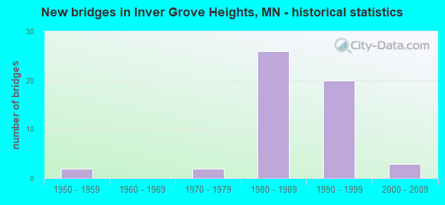
- New bridges - historical statistics
- 21950-1959
- 21970-1979
- 261980-1989
- 201990-1999
- 32000-2009
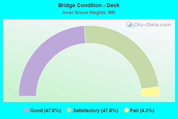
- Bridge Condition - Deck
- 47.8%Good
- 47.8%Satisfactory
- 4.3%Fair
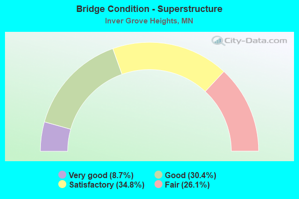
- Bridge Condition - Superstructure
- 8.7%Very good
- 30.4%Good
- 34.8%Satisfactory
- 26.1%Fair
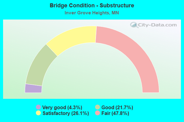
- Bridge Condition - Substructure
- 4.3%Very good
- 21.7%Good
- 26.1%Satisfactory
- 47.8%Fair
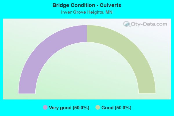
- Bridge Condition - Culverts
- 50.0%Very good
- 50.0%Good
Find on map >> Show street view
Structure Number: 19022, Location: 1.9 MI S OF JCT TH 494 (Lat: 44.847922, Lng: -93.059678), Route carried "on" structure: County highway 26, Year Built: 1990, Status: Open, Structure Length: 9.75m (31.99ft), Average Daily Traffic: 12,100 (year 2016), Average Future Daily Traffic: 12,100 (year 2039), Design Load: HS 25 or greater, Features Intersected: US 52
Minimum Vertical Clearance: 30+ m (98+ ft), Kilometerpoint: 0.000, Lanes on structure: 4, Lanes under structure: 4, Owner: State Highway Agency, Approaching Roadway Width: 27.4m (89.9ft), Skew: 20 degrees, Material/Design: Prestressed concrete, Design/Construction: Stringer/Multi-beam, Number Of Spans In Main Unit: 4, Length of Maximum Span: 28.8m (94.5ft), Curb or Sidewalk Widths: Left: 0.0m, Right: 3.0m (9.8ft), Curb-To-Curb Width: 25.6m (84.0ft), Out-to-Out Width: 31.8m (104.3ft)
Condition: Deck: Satisfactory, Superstructure: Satisfactory, Substructure: Fair, Operating Rating: 71.8 metric tons, Method Used To Determine Operating Rating: Load Factor (LF), Inventory Rating: 49.0 metric tons, Method Used To Determine Inventory Rating: Load Factor (LF), Structural Evaluation: Somewhat better than minimum adequacy, Deck Geometry: Superior to present desirable criteria, Underclear: Equal to present minimum criteria, Approach Roadway Alignment: Equal to present desirable criteria, Designated Inspection Frequency: Every 24 months, Inspection Date: April 2021, Deck Structure Type: Concrete Cast-file-Place, Wearing Surface/Protective System: Wearing Surface: Low Slump Concrete, Deck Protection: Epoxy Coated Reinforcing
Find on map >> Show street view
Structure Number: 19023, Location: 3.5 MI S OF JCT TH 494 (Lat: 44.823933, Lng: -93.057731), Route carried "on" structure: State highway 55, Year Built: 1992, Status: Open, Structure Length: 13.44m (44.09ft), Average Daily Traffic: 10,400 (year 2017), Truck Traffic: 6%, Average Future Daily Traffic: 10,400 (year 2039), Design Load: HS 25 or greater, Features Intersected: US 52 SB
Minimum Vertical Clearance: 30+ m (98+ ft), Kilometerpoint: 0.000, Lanes on structure: 2, Lanes under structure: 2, Base Highway Network: Yes, Owner: State Highway Agency, Approaching Roadway Width: 12.2m (40.0ft), Skew: 6 degrees, Material/Design: Steel continuous, Design/Construction: Stringer/Multi-beam, Number Of Spans In Main Unit: 3, Length of Maximum Span: 54.4m (178.5ft), Curb-To-Curb Width: 12.4m (40.7ft), Out-to-Out Width: 13.4m (44.0ft)
Condition: Deck: Satisfactory, Superstructure: Satisfactory, Substructure: Satisfactory, Operating Rating: 78.4 metric tons, Method Used To Determine Operating Rating: Load Factor (LF), Inventory Rating: 47.3 metric tons, Method Used To Determine Inventory Rating: Load Factor (LF), Structural Evaluation: Equal to present minimum criteria, Deck Geometry: Better than present minimum criteria, Underclear: Somewhat better than minimum adequacy, Approach Roadway Alignment: Equal to present desirable criteria, Length Of Structure Improvement: 4.08m (13.39ft), Designated Inspection Frequency: Every 24 months, Inspection Date: July 2020, Bridge Improvement Cost: $999,999,000, Deck Structure Type: Concrete Cast-file-Place, Wearing Surface/Protective System: Wearing Surface: Low Slump Concrete, Deck Protection: Epoxy Coated Reinforcing
Find on map >> Show street view
Structure Number: 19024, Location: 0.3 MI NW OF W JCT TH 52 (Lat: 44.825181, Lng: -93.061050), Route carried "on" structure: County highway 73, Year Built: 1992, Status: Open, Structure Length: 8.36m (27.43ft), Average Daily Traffic: 7,200 (year 2016), Average Future Daily Traffic: 7,200 (year 2039), Design Load: HS 25 or greater, Features Intersected: TH 55
Minimum Vertical Clearance: 30+ m (98+ ft), Kilometerpoint: 0.000, Lanes on structure: 3, Lanes under structure: 4, Owner: State Highway Agency, Approaching Roadway Width: 18.3m (60.0ft), Skew: 2 degrees, Material/Design: Prestressed concrete, Design/Construction: Stringer/Multi-beam, Number Of Spans In Main Unit: 2, Length of Maximum Span: 41.0m (134.5ft), Curb or Sidewalk Widths: Left: 3.0m (9.8ft), Right: 0.0m, Curb-To-Curb Width: 18.2m (59.7ft), Out-to-Out Width: 22.6m (74.1ft)
Condition: Deck: Good, Superstructure: Good, Substructure: Good, Operating Rating: 83.9 metric tons, Method Used To Determine Operating Rating: Load Factor (LF), Inventory Rating: 39.0 metric tons, Method Used To Determine Inventory Rating: Load Factor (LF), Structural Evaluation: Better than present minimum criteria, Deck Geometry: Superior to present desirable criteria, Underclear: Somewhat better than minimum adequacy, Approach Roadway Alignment: Equal to present desirable criteria, Designated Inspection Frequency: Every 24 months, Inspection Date: July 2020, Deck Structure Type: Concrete Cast-file-Place, Wearing Surface/Protective System: Wearing Surface: Low Slump Concrete, Deck Protection: Epoxy Coated Reinforcing
Find on map >> Show street view
Structure Number: 19035, Location: 1.4 MI S OF JCT TH56; 52 (Lat: 44.796811, Lng: -93.037619), Route carried "on" structure: City street 115, Year Built: 2009, Status: Open, Structure Length: 3.75m (12.30ft), Average Daily Traffic: 1 (year 2009), Average Future Daily Traffic: 1,800 (year 2028), Design Load: HL 93, Features Intersected: UP RR
Minimum Vertical Clearance: 30+ m (98+ ft), Kilometerpoint: 0.000, Lanes on structure: 2, Owner: City or Municipal Highway Agency, Approaching Roadway Width: 9.1m (29.9ft), Skew: 1 degrees, Material/Design: Prestressed concrete, Design/Construction: Stringer/Multi-beam, Number Of Spans In Main Unit: 1, Length of Maximum Span: 36.2m (118.8ft), Curb or Sidewalk Widths: Left: 0.0m, Right: 3.7m (12.1ft), Curb-To-Curb Width: 9.1m (29.9ft), Out-to-Out Width: 13.7m (44.9ft)
Condition: Deck: Good, Superstructure: Very good, Substructure: Very good, Operating Rating: 72.3 metric tons, Method Used To Determine Operating Rating: Load Factor (LF), Inventory Rating: 32.2 metric tons, Method Used To Determine Inventory Rating: Load Factor (LF), Structural Evaluation: Better than present minimum criteria, Deck Geometry: Better than present minimum criteria, Underclear: Equal to present minimum criteria, Approach Roadway Alignment: Equal to present desirable criteria, Designated Inspection Frequency: Every 24 months, Inspection Date: October 2020, Deck Structure Type: Concrete Cast-file-Place, Wearing Surface/Protective System: Deck Protection: Epoxy Coated Reinforcing
Find on map >> Show street view
Structure Number: 19041, Location: 2.9 MI S OF JCT TH 494 (Lat: 44.833417, Lng: -93.059611), Route carried "on" structure: County highway 28, Year Built: 1991, Status: Open, Structure Length: 10.18m (33.40ft), Average Daily Traffic: 10,300 (year 2017), Average Future Daily Traffic: 10,300 (year 2039), Design Load: HS 25 or greater, Features Intersected: US 52
Minimum Vertical Clearance: 30+ m (98+ ft), Kilometerpoint: 0.000, Lanes on structure: 5, Lanes under structure: 4, Owner: State Highway Agency, Approaching Roadway Width: 24.7m (81.0ft), Material/Design: Prestressed concrete, Design/Construction: Stringer/Multi-beam, Number Of Spans In Main Unit: 4, Length of Maximum Span: 28.7m (94.2ft), Curb or Sidewalk Widths: Left: 3.0m (9.8ft), Right: 2.4m (7.9ft), Curb-To-Curb Width: 24.7m (81.0ft), Out-to-Out Width: 31.8m (104.3ft)
Condition: Deck: Good, Superstructure: Good, Substructure: Good, Operating Rating: 72.2 metric tons, Method Used To Determine Operating Rating: Load Factor (LF), Inventory Rating: 41.2 metric tons, Method Used To Determine Inventory Rating: Load Factor (LF), Structural Evaluation: Better than present minimum criteria, Deck Geometry: Superior to present desirable criteria, Underclear: Somewhat better than minimum adequacy, Approach Roadway Alignment: Equal to present desirable criteria, Designated Inspection Frequency: Every 24 months, Inspection Date: April 2021, Deck Structure Type: Concrete Cast-file-Place, Wearing Surface/Protective System: Wearing Surface: Low Slump Concrete, Deck Protection: Epoxy Coated Reinforcing
Find on map >> Show street view
Structure Number: 19042, Location: 0.7 MI S OF JCT TH 494 (Lat: 44.865658, Lng: -93.059958), Route carried "on" structure: City street 106, Year Built: 1988, Status: Open, Structure Length: 8.63m (28.31ft), Average Daily Traffic: 8,000 (year 2014), Average Future Daily Traffic: 8,000 (year 2039), Design Load: HS 25 or greater, Features Intersected: US 52
Minimum Vertical Clearance: 30+ m (98+ ft), Kilometerpoint: 0.000, Lanes on structure: 6, Lanes under structure: 6, Owner: State Highway Agency, Approaching Roadway Width: 18.3m (60.0ft), Skew: 1 degrees, Material/Design: Prestressed concrete, Design/Construction: Stringer/Multi-beam, Number Of Spans In Main Unit: 2, Length of Maximum Span: 43.6m (143.0ft), Curb or Sidewalk Widths: Left: 2.3m (7.5ft), Right: 0.0m, Curb-To-Curb Width: 27.4m (89.9ft), Out-to-Out Width: 31.0m (101.7ft)
Condition: Deck: Satisfactory, Superstructure: Satisfactory, Substructure: Fair, Operating Rating: 77.5 metric tons, Method Used To Determine Operating Rating: Load Factor (LF), Inventory Rating: 43.4 metric tons, Method Used To Determine Inventory Rating: Load Factor (LF), Structural Evaluation: Somewhat better than minimum adequacy, Deck Geometry: Better than present minimum criteria, Underclear: Superior to present desirable criteria, Approach Roadway Alignment: Equal to present desirable criteria, Designated Inspection Frequency: Every 24 months, Inspection Date: April 2021, Deck Structure Type: Concrete Cast-file-Place, Wearing Surface/Protective System: Wearing Surface: Low Slump Concrete, Deck Protection: Epoxy Coated Reinforcing
Find on map >> Show street view
Structure Number: 19045, Location: AT THE JCT TH 55 (Lat: 44.833781, Lng: -93.086589), Route carried "on" structure: State highway 3, Year Built: 1994, Status: Open, Structure Length: 8.35m (27.40ft), Average Daily Traffic: 10,066 (year 2019), Truck Traffic: 5%, Average Future Daily Traffic: 10,200 (year 2039), Design Load: HS 25 or greater, Features Intersected: TH 55
Minimum Vertical Clearance: 30+ m (98+ ft), Kilometerpoint: 0.000, Lanes on structure: 3, Lanes under structure: 4, Owner: State Highway Agency, Approaching Roadway Width: 22.6m (74.1ft), Skew: 20 degrees, Material/Design: Prestressed concrete, Design/Construction: Stringer/Multi-beam, Number Of Spans In Main Unit: 2, Length of Maximum Span: 42.2m (138.5ft), Curb-To-Curb Width: 19.8m (65.0ft), Out-to-Out Width: 22.6m (74.1ft)
Condition: Deck: Good, Superstructure: Fair, Substructure: Good, Operating Rating: 77.1 metric tons, Method Used To Determine Operating Rating: Load Factor (LF), Inventory Rating: 40.5 metric tons, Method Used To Determine Inventory Rating: Load Factor (LF), Structural Evaluation: Somewhat better than minimum adequacy, Deck Geometry: Superior to present desirable criteria, Underclear: Somewhat better than minimum adequacy, Approach Roadway Alignment: Equal to present desirable criteria, Designated Inspection Frequency: Every 24 months, Inspection Date: April 2021, Deck Structure Type: Concrete Cast-file-Place, Wearing Surface/Protective System: Wearing Surface: Low Slump Concrete, Deck Protection: Epoxy Coated Reinforcing
Find on map >> Show street view
Structure Number: 19047, Location: 4.4 MI S OF JCT TH 494 (Lat: 44.815994, Lng: -93.044364), Route carried "on" structure: US 52, Year Built: 1994, Status: Open, Structure Length: 5.66m (18.57ft), Average Daily Traffic: 28,000 (year 2019), Truck Traffic: 13%, Average Future Daily Traffic: 27,000 (year 2039), Design Load: HS 25 or greater, Features Intersected: Concord Blvd
Minimum Vertical Clearance: 30+ m (98+ ft), Kilometerpoint: 0.000, Lanes on structure: 4, Lanes under structure: 5, Base Highway Network: Yes, Owner: State Highway Agency, Approaching Roadway Width: 17.1m (56.1ft), Material/Design: Prestressed concrete, Design/Construction: Stringer/Multi-beam, Number Of Spans In Main Unit: 3, Length of Maximum Span: 30.8m (101.0ft), Curb-To-Curb Width: 22.7m (74.5ft), Out-to-Out Width: 23.7m (77.8ft)
Condition: Deck: Good, Superstructure: Good, Substructure: Satisfactory, Operating Rating: 65.7 metric tons, Method Used To Determine Operating Rating: Load Factor (LF), Inventory Rating: 39.2 metric tons, Method Used To Determine Inventory Rating: Load Factor (LF), Structural Evaluation: Equal to present minimum criteria, Deck Geometry: Superior to present desirable criteria, Underclear: Equal to present minimum criteria, Approach Roadway Alignment: Equal to present desirable criteria, Designated Inspection Frequency: Every 24 months, Inspection Date: July 2020, Deck Structure Type: Concrete Cast-file-Place, Wearing Surface/Protective System: Wearing Surface: Low Slump Concrete, Deck Protection: Epoxy Coated Reinforcing
Find on map >> Show street view
Structure Number: 19048, Location: 4.4 MI S OF JCT TH 494 (Lat: 44.815811, Lng: -93.044753), Route carried "on" structure: US 52, Year Built: 1994, Status: Open, Structure Length: 5.66m (18.57ft), Average Daily Traffic: 27,000 (year 2017), Truck Traffic: 13%, Average Future Daily Traffic: 27,000 (year 2039), Design Load: HS 25 or greater, Features Intersected: Concord Blvd
Minimum Vertical Clearance: 30+ m (98+ ft), Kilometerpoint: 0.000, Lanes on structure: 4, Lanes under structure: 5, Base Highway Network: Yes, Owner: State Highway Agency, Approaching Roadway Width: 17.1m (56.1ft), Material/Design: Prestressed concrete, Design/Construction: Stringer/Multi-beam, Number Of Spans In Main Unit: 3, Length of Maximum Span: 30.8m (101.0ft), Curb-To-Curb Width: 18.8m (61.7ft), Out-to-Out Width: 19.8m (65.0ft)
Condition: Deck: Good, Superstructure: Good, Substructure: Fair, Operating Rating: 65.7 metric tons, Method Used To Determine Operating Rating: Load Factor (LF), Inventory Rating: 39.2 metric tons, Method Used To Determine Inventory Rating: Load Factor (LF), Structural Evaluation: Somewhat better than minimum adequacy, Deck Geometry: Meets minimum limits, Underclear: Equal to present minimum criteria, Approach Roadway Alignment: Equal to present desirable criteria, Designated Inspection Frequency: Every 24 months, Inspection Date: July 2020, Deck Structure Type: Concrete Cast-file-Place, Wearing Surface/Protective System: Wearing Surface: Low Slump Concrete, Deck Protection: Epoxy Coated Reinforcing
Find on map >> Show street view
Structure Number: 19078, Location: 5.8 MI S OF JCT TH 494 (Lat: 44.796600, Lng: -93.038147), Route carried "on" structure: US 52, Year Built: 1978, Status: Open, Structure Length: 4.49m (14.73ft), Average Daily Traffic: 23,250 (year 2015), Truck Traffic: 15%, Average Future Daily Traffic: 23,250 (year 2039), Design Load: HS 20, Features Intersected: UP RR
Minimum Vertical Clearance: 30+ m (98+ ft), Kilometerpoint: 0.000, Lanes on structure: 2, Base Highway Network: Yes, Owner: State Highway Agency, Approaching Roadway Width: 10.7m (35.1ft), Skew: 1 degrees, Material/Design: Prestressed concrete, Design/Construction: Stringer/Multi-beam, Number Of Spans In Main Unit: 3, Length of Maximum Span: 14.9m (48.9ft), Curb-To-Curb Width: 12.4m (40.7ft), Out-to-Out Width: 13.5m (44.3ft)
Condition: Deck: Good, Superstructure: Good, Substructure: Satisfactory, Operating Rating: 42.0 metric tons, Method Used To Determine Operating Rating: Load Factor (LF), Inventory Rating: 27.9 metric tons, Method Used To Determine Inventory Rating: Load Factor (LF), Structural Evaluation: Equal to present minimum criteria, Deck Geometry: Better than present minimum criteria, Underclear: Somewhat better than minimum adequacy, Approach Roadway Alignment: Equal to present desirable criteria, Designated Inspection Frequency: Every 24 months, Inspection Date: July 2020, Deck Structure Type: Concrete Cast-file-Place, Wearing Surface/Protective System: Wearing Surface: Low Slump Concrete, Deck Protection: Epoxy Coated Reinforcing
Find on map >> Show street view
Structure Number: 19079, Location: 5.4 MI S OF JCT TH 494 (Lat: 44.801942, Lng: -93.039428), Route carried "on" structure: US 52, Year Built: 1978, Status: Open, Structure Length: 5.19m (17.03ft), Average Daily Traffic: 23,250 (year 2015), Truck Traffic: 15%, Average Future Daily Traffic: 23,250 (year 2039), Design Load: HS 20, Features Intersected: UP RR
Minimum Vertical Clearance: 30+ m (98+ ft), Kilometerpoint: 0.000, Lanes on structure: 2, Base Highway Network: Yes, Owner: State Highway Agency, Approaching Roadway Width: 11.6m (38.1ft), Skew: 3 degrees, Material/Design: Prestressed concrete, Design/Construction: Stringer/Multi-beam, Number Of Spans In Main Unit: 3, Length of Maximum Span: 16.8m (55.1ft), Curb-To-Curb Width: 12.4m (40.7ft), Out-to-Out Width: 13.5m (44.3ft)
Condition: Deck: Good, Superstructure: Satisfactory, Substructure: Good, Operating Rating: 46.5 metric tons, Method Used To Determine Operating Rating: Load Factor (LF), Inventory Rating: 27.9 metric tons, Method Used To Determine Inventory Rating: Load Factor (LF), Structural Evaluation: Equal to present minimum criteria, Deck Geometry: Better than present minimum criteria, Underclear: Somewhat better than minimum adequacy, Approach Roadway Alignment: Equal to present desirable criteria, Designated Inspection Frequency: Every 24 months, Inspection Date: April 2021, Deck Structure Type: Concrete Cast-file-Place, Wearing Surface/Protective System: Wearing Surface: Low Slump Concrete, Deck Protection: Epoxy Coated Reinforcing
Find on map >> Show street view
Structure Number: 19083, Location: 1.4 MI S OF JCT TH 494 (Lat: 44.854453, Lng: -93.059708), Route carried "on" structure: City street 104, Year Built: 1990, Status: Open, Structure Length: 12.24m (40.16ft), Average Daily Traffic: 1,350 (year 2014), Average Future Daily Traffic: 1,350 (year 2039), Design Load: HS 25 or greater, Features Intersected: US 52
Minimum Vertical Clearance: 30+ m (98+ ft), Kilometerpoint: 0.000, Lanes on structure: 2, Lanes under structure: 4, Owner: State Highway Agency, Approaching Roadway Width: 13.4m (44.0ft), Skew: 5 degrees, Material/Design: Prestressed concrete, Design/Construction: Stringer/Multi-beam, Number Of Spans In Main Unit: 4, Length of Maximum Span: 37.5m (123.0ft), Curb or Sidewalk Widths: Left: 0.0m, Right: 2.4m (7.9ft), Curb-To-Curb Width: 13.4m (44.0ft), Out-to-Out Width: 16.7m (54.8ft)
Condition: Deck: Good, Superstructure: Good, Substructure: Satisfactory, Operating Rating: 55.5 metric tons, Method Used To Determine Operating Rating: Load Factor (LF), Inventory Rating: 33.3 metric tons, Method Used To Determine Inventory Rating: Load Factor (LF), Structural Evaluation: Equal to present minimum criteria, Deck Geometry: Equal to present desirable criteria, Underclear: Somewhat better than minimum adequacy, Approach Roadway Alignment: Equal to present desirable criteria, Designated Inspection Frequency: Every 24 months, Inspection Date: April 2021, Deck Structure Type: Concrete Cast-file-Place, Wearing Surface/Protective System: Wearing Surface: Low Slump Concrete, Deck Protection: Epoxy Coated Reinforcing
Find on map >> Show street view
Structure Number: 19085, Location: 2.4 MI S OF JCT TH 494 (Lat: 44.841492, Lng: -93.059656), Route carried "on" structure: City street 102, Year Built: 1991, Status: Open, Structure Length: 9.83m (32.25ft), Average Daily Traffic: 500 (year 2014), Average Future Daily Traffic: 500 (year 2039), Design Load: HS 25 or greater, Features Intersected: US 52
Minimum Vertical Clearance: 30+ m (98+ ft), Kilometerpoint: 0.000, Lanes on structure: 2, Lanes under structure: 4, Owner: State Highway Agency, Approaching Roadway Width: 13.4m (44.0ft), Material/Design: Prestressed concrete, Design/Construction: Stringer/Multi-beam, Number Of Spans In Main Unit: 4, Length of Maximum Span: 29.0m (95.1ft), Curb or Sidewalk Widths: Left: 2.9m (9.5ft), Right: 0.0m, Curb-To-Curb Width: 13.4m (44.0ft), Out-to-Out Width: 17.6m (57.7ft)
Condition: Deck: Good, Superstructure: Good, Substructure: Good, Operating Rating: 55.7 metric tons, Method Used To Determine Operating Rating: Load Factor (LF), Inventory Rating: 33.3 metric tons, Method Used To Determine Inventory Rating: Load Factor (LF), Structural Evaluation: Better than present minimum criteria, Deck Geometry: Superior to present desirable criteria, Underclear: Superior to present desirable criteria, Approach Roadway Alignment: Equal to present desirable criteria, Designated Inspection Frequency: Every 24 months, Inspection Date: April 2021, Deck Structure Type: Concrete Cast-file-Place, Wearing Surface/Protective System: Wearing Surface: Low Slump Concrete, Deck Protection: Epoxy Coated Reinforcing
Find on map >> Show street view
Structure Number: 19831, Location: 2.0 MI E OF JCT TH 35E (Lat: 44.861167, Lng: -93.105958), Route carried "on" structure: County highway 63, Year Built: 1985, Status: Open, Structure Length: 10.12m (33.20ft), Average Daily Traffic: 4,500 (year 2017), Average Future Daily Traffic: 4,500 (year 2039), Design Load: HS 20, Features Intersected: I 494
Minimum Vertical Clearance: 30+ m (98+ ft), Kilometerpoint: 0.000, Lanes on structure: 2, Lanes under structure: 6, Owner: State Highway Agency, Approaching Roadway Width: 9.1m (29.9ft), Skew: 3 degrees, Material/Design: Steel continuous, Design/Construction: Stringer/Multi-beam, Number Of Spans In Main Unit: 2, Length of Maximum Span: 54.9m (180.1ft), Curb or Sidewalk Widths: Left: 1.8m (5.9ft), Right: 0.0m, Curb-To-Curb Width: 13.8m (45.3ft), Out-to-Out Width: 16.6m (54.5ft)
Condition: Deck: Satisfactory, Superstructure: Satisfactory, Substructure: Fair, Operating Rating: 84.9 metric tons, Method Used To Determine Operating Rating: Load Factor (LF), Inventory Rating: 50.6 metric tons, Method Used To Determine Inventory Rating: Load Factor (LF), Structural Evaluation: Somewhat better than minimum adequacy, Deck Geometry: Superior to present desirable criteria, Underclear: Equal to present minimum criteria, Approach Roadway Alignment: Better than present minimum criteria, Designated Inspection Frequency: Every 24 months, Inspection Date: November 2021, Deck Structure Type: Concrete Cast-file-Place, Wearing Surface/Protective System: Wearing Surface: Low Slump Concrete, Deck Protection: Other
Find on map >> Show street view
Structure Number: 19832, Location: 1.0 MI W OF JCT TH 52 (Lat: 44.872936, Lng: -93.080536), Route carried "on" structure: State highway 3, Year Built: 1985, Status: Open, Structure Length: 16.08m (52.76ft), Average Daily Traffic: 8,684 (year 2019), Truck Traffic: 5%, Average Future Daily Traffic: 8,800 (year 2039), Design Load: HS 20, Features Intersected: I 494
Minimum Vertical Clearance: 30+ m (98+ ft), Kilometerpoint: 0.000, Lanes on structure: 4, Lanes under structure: 6, Owner: State Highway Agency, Approaching Roadway Width: 20.1m (65.9ft), Skew: 25 degrees, Material/Design: Steel continuous, Design/Construction: Stringer/Multi-beam, Number Of Spans In Main Unit: 4, Length of Maximum Span: 53.0m (173.9ft), Curb or Sidewalk Widths: Left: 0.0m, Right: 1.8m (5.9ft), Curb-To-Curb Width: 25.6m (84.0ft), Out-to-Out Width: 30.4m (99.7ft)
Condition: Deck: Fair, Superstructure: Satisfactory, Substructure: Fair, Operating Rating: 72.5 metric tons, Method Used To Determine Operating Rating: Load Factor (LF), Inventory Rating: 43.4 metric tons, Method Used To Determine Inventory Rating: Load Factor (LF), Structural Evaluation: Somewhat better than minimum adequacy, Deck Geometry: Superior to present desirable criteria, Underclear: Meets minimum limits, Approach Roadway Alignment: Equal to present desirable criteria, Designated Inspection Frequency: Every 24 months, Inspection Date: November 2021, Deck Structure Type: Concrete Cast-file-Place, Wearing Surface/Protective System: Wearing Surface: Low Slump Concrete, Deck Protection: Other
Find on map >> Show street view
Structure Number: 19837, Location: 0.4 MI E OF JCT TH 52 (Lat: 44.874794, Lng: -93.052636), Route carried "on" structure: City street 443, Year Built: 1983, Status: Open, Structure Length: 7.73m (25.36ft), Average Daily Traffic: 5,200 (year 2017), Average Future Daily Traffic: 5,200 (year 2039), Design Load: HS 20, Features Intersected: I 494
Minimum Vertical Clearance: 30+ m (98+ ft), Kilometerpoint: 0.000, Lanes on structure: 2, Lanes under structure: 6, Owner: State Highway Agency, Approaching Roadway Width: 13.4m (44.0ft), Material/Design: Steel continuous, Design/Construction: Stringer/Multi-beam, Number Of Spans In Main Unit: 2, Length of Maximum Span: 39.0m (128.0ft), Curb or Sidewalk Widths: Left: 1.8m (5.9ft), Right: 1.8m (5.9ft), Curb-To-Curb Width: 13.4m (44.0ft), Out-to-Out Width: 17.2m (56.4ft)
Condition: Deck: Satisfactory, Superstructure: Fair, Substructure: Fair, Operating Rating: 78.5 metric tons, Method Used To Determine Operating Rating: Load Factor (LF), Inventory Rating: 47.0 metric tons, Method Used To Determine Inventory Rating: Load Factor (LF), Structural Evaluation: Somewhat better than minimum adequacy, Deck Geometry: Equal to present minimum criteria, Underclear: Equal to present minimum criteria, Approach Roadway Alignment: Equal to present desirable criteria, Designated Inspection Frequency: Every 24 months, Inspection Date: September 2021, Deck Structure Type: Concrete Cast-file-Place, Wearing Surface/Protective System: Wearing Surface: Low Slump Concrete, Deck Protection: Epoxy Coated Reinforcing
Find on map >> Show street view
Structure Number: 19853, Location: 0.7 MI W OF JCT TH 52 (Lat: 44.875164, Lng: -93.075653), Route carried "on" structure: State highway 62, Year Built: 1985, Status: Open, Structure Length: 15.27m (50.10ft), Average Daily Traffic: 13,000 (year 2019), Truck Traffic: 2%, Average Future Daily Traffic: 12,500 (year 2039), Design Load: HS 20, Features Intersected: I 494, WB ON RAMP
Minimum Vertical Clearance: 30+ m (98+ ft), Kilometerpoint: 0.000, Lanes on structure: 2, Lanes under structure: 7, Owner: State Highway Agency, Approaching Roadway Width: 11.9m (39.0ft), Skew: 5 degrees, Material/Design: Steel continuous, Design/Construction: Stringer/Multi-beam, Number Of Spans In Main Unit: 3, Length of Maximum Span: 54.9m (180.1ft), Curb-To-Curb Width: 12.4m (40.7ft), Out-to-Out Width: 13.5m (44.3ft)
Condition: Deck: Satisfactory, Superstructure: Fair, Substructure: Fair, Operating Rating: 88.2 metric tons, Method Used To Determine Operating Rating: Load Factor (LF), Inventory Rating: 52.2 metric tons, Method Used To Determine Inventory Rating: Load Factor (LF), Structural Evaluation: Somewhat better than minimum adequacy, Deck Geometry: Better than present minimum criteria, Underclear: Somewhat better than minimum adequacy, Approach Roadway Alignment: Equal to present desirable criteria, Designated Inspection Frequency: Every 24 months, Inspection Date: September 2021, Deck Structure Type: Concrete Cast-file-Place, Wearing Surface/Protective System: Wearing Surface: Low Slump Concrete, Deck Protection: Other
Find on map >> Show street view
Structure Number: 19854, Location: 0.2 MI W OF JCT TH 52 (Lat: 44.874817, Lng: -93.064581), Route carried "on" structure: County highway 73, Year Built: 1985, Status: Open, Structure Length: 14.90m (48.88ft), Average Daily Traffic: 7,600 (year 2017), Average Future Daily Traffic: 7,600 (year 2039), Design Load: HS 20, Features Intersected: I 494; RAMPS
Minimum Vertical Clearance: 30+ m (98+ ft), Kilometerpoint: 0.000, Lanes on structure: 2, Lanes under structure: 14, Owner: State Highway Agency, Approaching Roadway Width: 14.0m (45.9ft), Skew: 1 degrees, Material/Design: Steel continuous, Design/Construction: Stringer/Multi-beam, Number Of Spans In Main Unit: 4, Length of Maximum Span: 45.7m (149.9ft), Curb or Sidewalk Widths: Left: 0.0m, Right: 3.0m (9.8ft), Curb-To-Curb Width: 15.9m (52.2ft), Out-to-Out Width: 20.1m (65.9ft)
Condition: Deck: Satisfactory, Superstructure: Satisfactory, Substructure: Fair, Operating Rating: 71.2 metric tons, Method Used To Determine Operating Rating: Load Factor (LF), Inventory Rating: 42.8 metric tons, Method Used To Determine Inventory Rating: Load Factor (LF), Structural Evaluation: Somewhat better than minimum adequacy, Deck Geometry: Superior to present desirable criteria, Underclear: Somewhat better than minimum adequacy, Approach Roadway Alignment: Equal to present desirable criteria, Designated Inspection Frequency: Every 24 months, Inspection Date: September 2021, Deck Structure Type: Concrete Cast-file-Place, Wearing Surface/Protective System: Wearing Surface: Low Slump Concrete, Deck Protection: Epoxy Coated Reinforcing
Find on map >> Show street view
Structure Number: 19855, Location: AT THE JCT TH 52; 494 (Lat: 44.874650, Lng: -93.060856), Route carried "on" structure: US 52, Year Built: 1984, Status: Open, Structure Length: 10.56m (34.65ft), Average Daily Traffic: 32,500 (year 2017), Truck Traffic: 8%, Average Future Daily Traffic: 32,500 (year 2039), Design Load: HS 20, Features Intersected: I 494, COLL ROADS
Minimum Vertical Clearance: 30+ m (98+ ft), Kilometerpoint: 0.000, Lanes on structure: 2, Lanes under structure: 10, Base Highway Network: Yes, Owner: State Highway Agency, Approaching Roadway Width: 11.6m (38.1ft), Material/Design: Steel continuous, Design/Construction: Stringer/Multi-beam, Number Of Spans In Main Unit: 2, Length of Maximum Span: 52.1m (170.9ft), Curb-To-Curb Width: 18.0m (59.1ft), Out-to-Out Width: 19.0m (62.3ft)
Condition: Deck: Satisfactory, Superstructure: Fair, Substructure: Fair, Operating Rating: 77.2 metric tons, Method Used To Determine Operating Rating: Load Factor (LF), Inventory Rating: 46.2 metric tons, Method Used To Determine Inventory Rating: Load Factor (LF), Structural Evaluation: Somewhat better than minimum adequacy, Deck Geometry: Superior to present desirable criteria, Underclear: Somewhat better than minimum adequacy, Approach Roadway Alignment: Equal to present desirable criteria, Designated Inspection Frequency: Every 24 months, Inspection Date: September 2021, Deck Structure Type: Concrete Cast-file-Place, Wearing Surface/Protective System: Wearing Surface: Low Slump Concrete, Deck Protection: Epoxy Coated Reinforcing
Find on map >> Show street view
Structure Number: 19856, Location: AT THE JCT TH 52; 494 (Lat: 44.874767, Lng: -93.060561), Route carried "on" structure: US 52, Year Built: 1984, Status: Open, Structure Length: 10.56m (34.65ft), Average Daily Traffic: 31,500 (year 2019), Truck Traffic: 6%, Average Future Daily Traffic: 32,500 (year 2039), Design Load: HS 20, Features Intersected: I 494, COLL ROADS
Minimum Vertical Clearance: 30+ m (98+ ft), Kilometerpoint: 0.000, Lanes on structure: 2, Lanes under structure: 10, Base Highway Network: Yes, Owner: State Highway Agency, Approaching Roadway Width: 11.6m (38.1ft), Material/Design: Steel continuous, Design/Construction: Stringer/Multi-beam, Number Of Spans In Main Unit: 2, Length of Maximum Span: 52.1m (170.9ft), Curb-To-Curb Width: 18.0m (59.1ft), Out-to-Out Width: 19.0m (62.3ft)
Condition: Deck: Satisfactory, Superstructure: Fair, Substructure: Fair, Operating Rating: 77.2 metric tons, Method Used To Determine Operating Rating: Load Factor (LF), Inventory Rating: 46.2 metric tons, Method Used To Determine Inventory Rating: Load Factor (LF), Structural Evaluation: Somewhat better than minimum adequacy, Deck Geometry: Superior to present desirable criteria, Underclear: Equal to present minimum criteria, Approach Roadway Alignment: Equal to present desirable criteria, Designated Inspection Frequency: Every 24 months, Inspection Date: September 2021, Deck Structure Type: Concrete Cast-file-Place, Wearing Surface/Protective System: Wearing Surface: Low Slump Concrete, Deck Protection: Other
Find on map >> Show street view
Structure Number: 19R01, Location: 0.7 MI N OF S JCT TH 55 (Lat: 44.778392, Lng: -93.034789), Route carried "on" structure: City street 75, Year Built: 2003, Status: Open, Structure Length: 7.12m (23.36ft), Average Daily Traffic: 7,000 (year 2014), Average Future Daily Traffic: 7,000 (year 2039), Design Load: HS 25 or greater, Features Intersected: US 52
Minimum Vertical Clearance: 30+ m (98+ ft), Kilometerpoint: 0.000, Lanes on structure: 5, Lanes under structure: 4, Owner: State Highway Agency, Approaching Roadway Width: 27.4m (89.9ft), Skew: 22 degrees, Material/Design: Prestressed concrete, Design/Construction: Stringer/Multi-beam, Number Of Spans In Main Unit: 2, Length of Maximum Span: 36.0m (118.1ft), Curb-To-Curb Width: 27.4m (89.9ft), Out-to-Out Width: 30.3m (99.4ft)
Condition: Deck: Good, Superstructure: Very good, Substructure: Satisfactory, Operating Rating: 65.3 metric tons, Method Used To Determine Operating Rating: Field evaluation and documented engineering judgment, Inventory Rating: 42.7 metric tons, Method Used To Determine Inventory Rating: Field evaluation and documented engineering judgment, Structural Evaluation: Equal to present minimum criteria, Deck Geometry: Superior to present desirable criteria, Underclear: Equal to present minimum criteria, Approach Roadway Alignment: Equal to present desirable criteria, Designated Inspection Frequency: Every 24 months, Inspection Date: July 2020, Deck Structure Type: Concrete Cast-file-Place, Wearing Surface/Protective System: Wearing Surface: Low Slump Concrete, Deck Protection: Epoxy Coated Reinforcing
Find on map >> Show street view
Structure Number: 9108, Location: 5.4 MI S OF JCT TH 494 (Lat: 44.802083, Lng: -93.039161), Route carried "on" structure: US 52, Year Built: 1958, Status: Open, Structure Length: 4.30m (14.11ft), Average Daily Traffic: 23,604 (year 2019), Truck Traffic: 13%, Average Future Daily Traffic: 23,250 (year 2039), Design Load: HS 20, Features Intersected: UP RR
Minimum Vertical Clearance: 30+ m (98+ ft), Kilometerpoint: 0.000, Lanes on structure: 2, Base Highway Network: Yes, Owner: State Highway Agency, Approaching Roadway Width: 11.6m (38.1ft), Skew: 3 degrees, Material/Design: Prestressed concrete, Design/Construction: Stringer/Multi-beam, Number Of Spans In Main Unit: 3, Length of Maximum Span: 14.1m (46.3ft), Curb-To-Curb Width: 10.5m (34.4ft), Out-to-Out Width: 11.7m (38.4ft)
Condition: Deck: Satisfactory, Superstructure: Fair, Substructure: Fair, Operating Rating: 75.1 metric tons, Method Used To Determine Operating Rating: Load Factor (LF), Inventory Rating: 45.7 metric tons, Method Used To Determine Inventory Rating: Load Factor (LF), Structural Evaluation: Somewhat better than minimum adequacy, Deck Geometry: Somewhat better than minimum adequacy, Underclear: Equal to present minimum criteria, Approach Roadway Alignment: Equal to present desirable criteria, Length Of Structure Improvement: 1.59m (5.22ft), Designated Inspection Frequency: Every 24 months, Inspection Date: July 2020, Bridge Improvement Cost: $640,000,000, Roadway Improvement Cost: $26,000,000, Total Project Cost: $394,000,000, Deck Structure Type: Concrete Cast-file-Place, Wearing Surface/Protective System: Wearing Surface: Low Slump Concrete, Deck Protection: Other
Find on map >> Show street view
Structure Number: 9109, Location: 5.8 MI S OF JCT TH 494 (Lat: 44.796711, Lng: -93.037858), Route carried "on" structure: US 52, Year Built: 1958, Status: Open, Structure Length: 3.85m (12.63ft), Average Daily Traffic: 23,604 (year 2019), Truck Traffic: 13%, Average Future Daily Traffic: 23,250 (year 2039), Design Load: HS 20, Features Intersected: UP RR
Minimum Vertical Clearance: 30+ m (98+ ft), Kilometerpoint: 0.000, Lanes on structure: 2, Base Highway Network: Yes, Owner: State Highway Agency, Approaching Roadway Width: 11.6m (38.1ft), Skew: 1 degrees, Material/Design: Prestressed concrete, Design/Construction: Stringer/Multi-beam, Number Of Spans In Main Unit: 3, Length of Maximum Span: 12.8m (42.0ft), Curb-To-Curb Width: 9.1m (29.9ft), Out-to-Out Width: 10.8m (35.4ft)
Condition: Deck: Satisfactory, Superstructure: Satisfactory, Substructure: Satisfactory, Operating Rating: 62.2 metric tons, Method Used To Determine Operating Rating: Load Factor (LF), Inventory Rating: 40.2 metric tons, Method Used To Determine Inventory Rating: Load Factor (LF), Structural Evaluation: Equal to present minimum criteria, Deck Geometry: Meets minimum limits, Underclear: Meets minimum limits, Approach Roadway Alignment: Equal to present desirable criteria, Length Of Structure Improvement: 1.40m (4.59ft), Designated Inspection Frequency: Every 24 months, Inspection Date: July 2020, Bridge Improvement Cost: $573,000,000, Roadway Improvement Cost: $26,000,000, Total Project Cost: $394,000,000, Deck Structure Type: Concrete Cast-file-Place, Wearing Surface/Protective System: Wearing Surface: Low Slump Concrete
Find on map >> Show street view
Structure Number: 96758, Location: 1.0 MI S OF JCT TH 494 (Lat: 44.860561, Lng: -93.059158), Route carried "on" structure: US 52, Year Built: 1990, Status: Open, Structure Length: 0.70m (2.30ft), Average Daily Traffic: 62,000 (year 2019), Truck Traffic: 9%, Average Future Daily Traffic: 62,000 (year 2039), Design Load: HS 20, Features Intersected: Pedestrian Trail
Minimum Vertical Clearance: 30+ m (98+ ft), Kilometerpoint: 0.000, Lanes on structure: 4, Base Highway Network: Yes, Owner: State Highway Agency, Approaching Roadway Width: 44.8m (147.0ft), Skew: 30 degrees, Material/Design: Concrete, Design/Construction: Culvert, Number Of Spans In Main Unit: 1, Length of Maximum Span: 6.1m (20.0ft)
Condition: Culverts: Good, Operating Rating: 39.2 metric tons, Method Used To Determine Operating Rating: Assigned rating based on Load Factor Design (LFD) reported in metric tons, Inventory Rating: 29.4 metric tons, Method Used To Determine Inventory Rating: Assigned rating based on Load Factor Design (LFD) reported in metric tons, Structural Evaluation: Better than present minimum criteria, Approach Roadway Alignment: Equal to present desirable criteria, Designated Inspection Frequency: Every 24 months, Inspection Date: April 2021
Find on map >> Show street view
Structure Number: 97556, Location: 0.2 MI W OF JCT CSAH 75 (Lat: 44.848103, Lng: -93.046897), Route carried "on" structure: County highway 26, Year Built: 1992, Status: Open, Structure Length: 0.66m (2.17ft), Average Daily Traffic: 10,000 (year 2016), Truck Traffic: 6%, Average Future Daily Traffic: 10,000 (year 2039), Design Load: HS 25 or greater, Features Intersected: PED WALK
Minimum Vertical Clearance: 30+ m (98+ ft), Kilometerpoint: 0.000, Lanes on structure: 4, Owner: County Highway Agency, Approaching Roadway Width: 19.5m (64.0ft), Material/Design: Concrete, Design/Construction: Culvert, Number Of Spans In Main Unit: 1, Length of Maximum Span: 6.1m (20.0ft), Curb or Sidewalk Widths: Left: 0.0m, Right: 2.4m (7.9ft)
Condition: Culverts: Very good, Operating Rating: 49.0 metric tons, Method Used To Determine Operating Rating: Field evaluation and documented engineering judgment, Inventory Rating: 32.7 metric tons, Method Used To Determine Inventory Rating: Field evaluation and documented engineering judgment, Structural Evaluation: Equal to present desirable criteria, Approach Roadway Alignment: Equal to present desirable criteria, Designated Inspection Frequency: Every 24 months, Inspection Date: December 2021
Find on map >> Show street view
Structure Number: 19022, Location: 1.9 MI S OF JCT TH 494 (Lat: 44.847922, Lng: -93.059678), Route carried "under" structure: US 52, Year Built: 1990, Structure Length: 0. m, Average Daily Traffic: 50,000 (year 2019), Truck Traffic: 11%, Features Intersected: US 52, Facility Carried by Structure: CSAH 26
Minimum Vertical Clearance: 5.06m (16.60ft), Kilometerpoint: 0.000, Lanes on structure: 4, Lanes under structure: 4, Material/Design: Prestressed concrete, Design/Construction: Stringer/Multi-beam, Length of Maximum Span: 28.8m (94.5ft)
Find on map >> Show street view
Structure Number: 19023, Location: 3.5 MI S OF JCT TH 494 (Lat: 44.823933, Lng: -93.057731), Route carried "under" structure: US 52, Year Built: 1992, Structure Length: 0. m, Average Daily Traffic: 14,000 (year 2004), Truck Traffic: 15%, Features Intersected: US 52 SB, Facility Carried by Structure: MN 55
Minimum Vertical Clearance: 4.94m (16.21ft), Kilometerpoint: 0.000, Lanes on structure: 2, Lanes under structure: 2, Material/Design: Steel continuous, Design/Construction: Stringer/Multi-beam, Length of Maximum Span: 54.4m (178.5ft)
Find on map >> Show street view
Structure Number: 19024, Location: 0.3 MI NW OF W JCT TH 52 (Lat: 44.825181, Lng: -93.061050), Route carried "under" structure: State highway 55, Year Built: 1992, Structure Length: 0. m, Average Daily Traffic: 20,527 (year 2019), Truck Traffic: 13%, Features Intersected: TH 55, Facility Carried by Structure: CSAH 73
Minimum Vertical Clearance: 4.94m (16.21ft), Kilometerpoint: 0.000, Lanes on structure: 3, Lanes under structure: 4, Material/Design: Prestressed concrete, Design/Construction: Stringer/Multi-beam, Length of Maximum Span: 41.0m (134.5ft)
Find on map >> Show street view
Structure Number: 19041, Location: 2.9 MI S OF JCT TH 494 (Lat: 44.833417, Lng: -93.059611), Route carried "under" structure: US 52, Year Built: 1991, Structure Length: 0. m, Average Daily Traffic: 37,000 (year 2019), Truck Traffic: 13%, Features Intersected: US 52, Facility Carried by Structure: CSAH 28
Minimum Vertical Clearance: 4.97m (16.31ft), Kilometerpoint: 0.000, Lanes on structure: 5, Lanes under structure: 4, Material/Design: Prestressed concrete, Design/Construction: Stringer/Multi-beam, Length of Maximum Span: 28.7m (94.2ft)
Find on map >> Show street view
Structure Number: 19042, Location: 0.7 MI S OF JCT TH 494 (Lat: 44.865658, Lng: -93.059958), Route carried "under" structure: US 52, Year Built: 1988, Structure Length: 0. m, Average Daily Traffic: 65,000 (year 2019), Truck Traffic: 9%, Features Intersected: US 52, Facility Carried by Structure: MSAS 106
Minimum Vertical Clearance: 5.97m (19.59ft), Kilometerpoint: 0.000, Lanes on structure: 6, Lanes under structure: 6, Material/Design: Prestressed concrete, Design/Construction: Stringer/Multi-beam, Length of Maximum Span: 43.6m (143.0ft)
Find on map >> Show street view
Structure Number: 19045, Location: AT THE JCT TH 55 (Lat: 44.833781, Lng: -93.086589), Route carried "under" structure: State highway 55, Year Built: 1994, Structure Length: 0. m, Average Daily Traffic: 24,500 (year 2019), Truck Traffic: 9%, Features Intersected: TH 55, Facility Carried by Structure: MN 3
Minimum Vertical Clearance: 5.00m (16.40ft), Kilometerpoint: 0.000, Lanes on structure: 3, Lanes under structure: 4, Material/Design: Prestressed concrete, Design/Construction: Stringer/Multi-beam, Length of Maximum Span: 42.2m (138.5ft)
Find on map >> Show street view
Structure Number: 19047, Location: 4.4 MI S OF JCT TH 494 (Lat: 44.815994, Lng: -93.044364), Route carried "under" structure: County highway 56, Year Built: 1994, Structure Length: 0. m, Average Daily Traffic: 10,900 (year 2005), Features Intersected: Concord Blvd, Facility Carried by Structure: US 52
Minimum Vertical Clearance: 5.67m (18.60ft), Kilometerpoint: 0.000, Lanes on structure: 4, Lanes under structure: 5, Material/Design: Prestressed concrete, Design/Construction: Stringer/Multi-beam, Length of Maximum Span: 30.8m (101.0ft)
Find on map >> Show street view
Structure Number: 19048, Location: 4.4 MI S OF JCT TH 494 (Lat: 44.815811, Lng: -93.044753), Route carried "under" structure: County highway 56, Year Built: 1994, Structure Length: 0. m, Average Daily Traffic: 10,900 (year 2005), Features Intersected: Concord Blvd, Facility Carried by Structure: US 52
Minimum Vertical Clearance: 5.00m (16.40ft), Kilometerpoint: 0.000, Lanes on structure: 4, Lanes under structure: 5, Material/Design: Prestressed concrete, Design/Construction: Stringer/Multi-beam, Length of Maximum Span: 30.8m (101.0ft)
Find on map >> Show street view
Structure Number: 19083, Location: 1.4 MI S OF JCT TH 494 (Lat: 44.854453, Lng: -93.059708), Route carried "under" structure: US 52, Year Built: 1990, Structure Length: 0. m, Average Daily Traffic: 62,000 (year 2019), Truck Traffic: 9%, Features Intersected: US 52, Facility Carried by Structure: MSAS 104
Minimum Vertical Clearance: 4.94m (16.21ft), Kilometerpoint: 0.000, Lanes on structure: 2, Lanes under structure: 4, Material/Design: Prestressed concrete, Design/Construction: Stringer/Multi-beam, Length of Maximum Span: 37.5m (123.0ft)
Find on map >> Show street view
Structure Number: 19085, Location: 2.4 MI S OF JCT TH 494 (Lat: 44.841492, Lng: -93.059656), Route carried "under" structure: US 52, Year Built: 1991, Structure Length: 0. m, Average Daily Traffic: 50,000 (year 2019), Truck Traffic: 11%, Features Intersected: US 52, Facility Carried by Structure: MSAS 102
Minimum Vertical Clearance: 5.49m (18.01ft), Kilometerpoint: 0.000, Lanes on structure: 2, Lanes under structure: 4, Material/Design: Prestressed concrete, Design/Construction: Stringer/Multi-beam, Length of Maximum Span: 29.0m (95.1ft)
Find on map >> Show street view
Structure Number: 19831, Location: 2.0 MI E OF JCT TH 35E (Lat: 44.861167, Lng: -93.105958), Route carried "under" structure: Interstate 494, Year Built: 1985, Structure Length: 0. m, Average Daily Traffic: 99,000 (year 2019), Truck Traffic: 6%, Features Intersected: I 494, Facility Carried by Structure: CSAH 63
Minimum Vertical Clearance: 6.07m (19.91ft), Kilometerpoint: 0.000, Lanes on structure: 2, Lanes under structure: 6, Material/Design: Steel continuous, Design/Construction: Stringer/Multi-beam, Length of Maximum Span: 54.9m (180.1ft)
Find on map >> Show street view
Structure Number: 19832, Location: 1.0 MI W OF JCT TH 52 (Lat: 44.872936, Lng: -93.080536), Route carried "under" structure: Interstate 494, Year Built: 1985, Structure Length: 0. m, Average Daily Traffic: 88,000 (year 2019), Truck Traffic: 6%, Features Intersected: I 494, Facility Carried by Structure: MN 3
Minimum Vertical Clearance: 7.53m (24.70ft), Kilometerpoint: 0.000, Lanes on structure: 4, Lanes under structure: 6, Material/Design: Steel continuous, Design/Construction: Stringer/Multi-beam, Length of Maximum Span: 53.0m (173.9ft)
Find on map >> Show street view
Structure Number: 19837, Location: 0.4 MI E OF JCT TH 52 (Lat: 44.874794, Lng: -93.052636), Route carried "under" structure: Interstate 494, Year Built: 1983, Structure Length: 0. m, Average Daily Traffic: 111,000 (year 2019), Truck Traffic: 6%, Features Intersected: I 494, Facility Carried by Structure: MUN 443
Minimum Vertical Clearance: 5.27m (17.29ft), Kilometerpoint: 0.000, Lanes on structure: 2, Lanes under structure: 6, Material/Design: Steel continuous, Design/Construction: Stringer/Multi-beam, Length of Maximum Span: 39.0m (128.0ft)
Find on map >> Show street view
Structure Number: 19853, Location: 0.7 MI W OF JCT TH 52 (Lat: 44.875164, Lng: -93.075653), Route carried "under" structure: Interstate 494, Year Built: 1985, Structure Length: 0. m, Average Daily Traffic: 88,000 (year 2019), Truck Traffic: 6%, Features Intersected: I 494, WB ON RAMP, Facility Carried by Structure: MN 62
Minimum Vertical Clearance: 6.04m (19.82ft), Kilometerpoint: 0.000, Lanes on structure: 2, Lanes under structure: 6, Material/Design: Steel continuous, Design/Construction: Stringer/Multi-beam, Length of Maximum Span: 54.9m (180.1ft)
Find on map >> Show street view
Structure Number: 19853, Location: 0.7 MI W OF JCT TH 52 (Lat: 44.875164, Lng: -93.075653), Route carried "under" structure: Ramp State highway 274, Year Built: 1985, Structure Length: 0. m, Average Daily Traffic: 8,000 (year 1996), Features Intersected: I 494, WB ON RAMP, Facility Carried by Structure: MN 62
Minimum Vertical Clearance: 6.71m (22.01ft), Kilometerpoint: 0.000, Lanes on structure: 2, Lanes under structure: 1, Material/Design: Steel continuous, Design/Construction: Stringer/Multi-beam, Length of Maximum Span: 54.9m (180.1ft)
Find on map >> Show street view
Structure Number: 19854, Location: 0.2 MI W OF JCT TH 52 (Lat: 44.874817, Lng: -93.064581), Route carried "under" structure: Ramp Interstate 4116, Year Built: 1985, Structure Length: 0. m, Average Daily Traffic: 6,000 (year 1996), Features Intersected: I 494; RAMPS, Facility Carried by Structure: CSAH 73
Minimum Vertical Clearance: 5.00m (16.40ft), Kilometerpoint: 0.000, Lanes on structure: 2, Lanes under structure: 2, Material/Design: Steel continuous, Design/Construction: Stringer/Multi-beam, Length of Maximum Span: 45.7m (149.9ft)
Find on map >> Show street view
Structure Number: 19854, Location: 0.2 MI W OF JCT TH 52 (Lat: 44.874817, Lng: -93.064581), Route carried "under" structure: Ramp Interstate 5517, Year Built: 1985, Structure Length: 0. m, Average Daily Traffic: 2,100 (year 1996), Features Intersected: I 494; RAMPS, Facility Carried by Structure: CSAH 73
Minimum Vertical Clearance: 5.09m (16.70ft), Kilometerpoint: 0.000, Lanes on structure: 2, Lanes under structure: 2, Material/Design: Steel continuous, Design/Construction: Stringer/Multi-beam, Length of Maximum Span: 45.7m (149.9ft)
Find on map >> Show street view
Structure Number: 19854, Location: 0.2 MI W OF JCT TH 52 (Lat: 44.874817, Lng: -93.064581), Route carried "under" structure: Interstate 494, Year Built: 1985, Structure Length: 0. m, Average Daily Traffic: 110,000 (year 2019), Truck Traffic: 6%, Features Intersected: I 494; RAMPS, Facility Carried by Structure: CSAH 73
Minimum Vertical Clearance: 5.00m (16.40ft), Kilometerpoint: 0.000, Lanes on structure: 2, Lanes under structure: 6, Material/Design: Steel continuous, Design/Construction: Stringer/Multi-beam, Length of Maximum Span: 45.7m (149.9ft)
Find on map >> Show street view
Structure Number: 19854, Location: 0.2 MI W OF JCT TH 52 (Lat: 44.874817, Lng: -93.064581), Route carried "under" structure: Ramp Interstate 5478, Year Built: 1985, Structure Length: 0. m, Average Daily Traffic: 2,100 (year 1996), Features Intersected: I 494; RAMPS, Facility Carried by Structure: CSAH 73
Minimum Vertical Clearance: 5.03m (16.50ft), Kilometerpoint: 0.000, Lanes on structure: 2, Lanes under structure: 2, Material/Design: Steel continuous, Design/Construction: Stringer/Multi-beam, Length of Maximum Span: 45.7m (149.9ft)
Find on map >> Show street view
Structure Number: 19854, Location: 0.2 MI W OF JCT TH 52 (Lat: 44.874817, Lng: -93.064581), Route carried "under" structure: Ramp Interstate 1167, Year Built: 1985, Structure Length: 0. m, Average Daily Traffic: 2,000 (year 1996), Features Intersected: I 494; RAMPS, Facility Carried by Structure: CSAH 73
Minimum Vertical Clearance: 5.12m (16.80ft), Kilometerpoint: 0.000, Lanes on structure: 2, Lanes under structure: 2, Material/Design: Steel continuous, Design/Construction: Stringer/Multi-beam, Length of Maximum Span: 45.7m (149.9ft)
Find on map >> Show street view
Structure Number: 19855, Location: AT THE JCT TH 52; 494 (Lat: 44.874650, Lng: -93.060856), Route carried "under" structure: Interstate 494, Year Built: 1984, Structure Length: 0. m, Average Daily Traffic: 110,000 (year 2019), Truck Traffic: 6%, Features Intersected: I 494, COLL ROADS, Facility Carried by Structure: US 52
Minimum Vertical Clearance: 5.06m (16.60ft), Kilometerpoint: 0.000, Lanes on structure: 2, Lanes under structure: 6, Material/Design: Steel continuous, Design/Construction: Stringer/Multi-beam, Length of Maximum Span: 52.1m (170.9ft)
Find on map >> Show street view
Structure Number: 19855, Location: AT THE JCT TH 52; 494 (Lat: 44.874650, Lng: -93.060856), Route carried "under" structure: Ramp US 5539, Year Built: 1984, Structure Length: 0. m, Average Daily Traffic: 3,000 (year 1996), Features Intersected: I 494, COLL ROADS, Facility Carried by Structure: US 52
Minimum Vertical Clearance: 5.06m (16.60ft), Kilometerpoint: 0.000, Lanes on structure: 2, Lanes under structure: 2, Material/Design: Steel continuous, Design/Construction: Stringer/Multi-beam, Length of Maximum Span: 52.1m (170.9ft)
Find on map >> Show street view
Structure Number: 19855, Location: AT THE JCT TH 52; 494 (Lat: 44.874650, Lng: -93.060856), Route carried "under" structure: Ramp US 5103, Year Built: 1984, Structure Length: 0. m, Average Daily Traffic: 3,000 (year 1996), Features Intersected: I 494, COLL ROADS, Facility Carried by Structure: US 52
Minimum Vertical Clearance: 5.30m (17.39ft), Kilometerpoint: 0.000, Lanes on structure: 2, Lanes under structure: 2, Material/Design: Steel continuous, Design/Construction: Stringer/Multi-beam, Length of Maximum Span: 52.1m (170.9ft)
Find on map >> Show street view
Structure Number: 19856, Location: AT THE JCT TH 52; 494 (Lat: 44.874767, Lng: -93.060561), Route carried "under" structure: Interstate 494, Year Built: 1984, Structure Length: 0. m, Average Daily Traffic: 110,000 (year 2019), Truck Traffic: 6%, Features Intersected: I 494, COLL ROADS, Facility Carried by Structure: US 52
Minimum Vertical Clearance: 5.24m (17.19ft), Kilometerpoint: 0.000, Lanes on structure: 2, Lanes under structure: 6, Material/Design: Steel continuous, Design/Construction: Stringer/Multi-beam, Length of Maximum Span: 52.1m (170.9ft)
Find on map >> Show street view
Structure Number: 19856, Location: AT THE JCT TH 52; 494 (Lat: 44.874767, Lng: -93.060561), Route carried "under" structure: Ramp US 5103, Year Built: 1984, Structure Length: 0. m, Average Daily Traffic: 3,000 (year 1996), Features Intersected: I 494, COLL ROADS, Facility Carried by Structure: US 52
Minimum Vertical Clearance: 5.52m (18.11ft), Kilometerpoint: 0.000, Lanes on structure: 2, Lanes under structure: 2, Material/Design: Steel continuous, Design/Construction: Stringer/Multi-beam, Length of Maximum Span: 52.1m (170.9ft)
Find on map >> Show street view
Structure Number: 19856, Location: AT THE JCT TH 52; 494 (Lat: 44.874767, Lng: -93.060561), Route carried "under" structure: Ramp US 5539, Year Built: 1984, Structure Length: 0. m, Average Daily Traffic: 3,000 (year 1996), Features Intersected: I 494, COLL ROADS, Facility Carried by Structure: US 52
Minimum Vertical Clearance: 5.21m (17.09ft), Kilometerpoint: 0.000, Lanes on structure: 2, Lanes under structure: 2, Material/Design: Steel continuous, Design/Construction: Stringer/Multi-beam, Length of Maximum Span: 52.1m (170.9ft)
Find on map >> Show street view
Structure Number: 19884, Location: 0.7 Mi West of Jct TH 52 (Lat: 44.875789, Lng: -93.075497), Route carried "under" structure: Ramp State highway 274, Year Built: 1985, Structure Length: 0. m, Average Daily Traffic: 8,000 (year 1996), Truck Traffic: 23%, Features Intersected: I 494 WB ON RAMP, Facility Carried by Structure: MN 62
Minimum Vertical Clearance: 4.94m (16.21ft), Kilometerpoint: 0.000, Lanes on structure: 2, Lanes under structure: 1, Material/Design: Steel continuous, Design/Construction: Stringer/Multi-beam, Length of Maximum Span: 26.8m (87.9ft)
Find on map >> Show street view
Structure Number: 19R01, Location: 0.7 MI N OF S JCT TH 55 (Lat: 44.778392, Lng: -93.034789), Route carried "under" structure: US 52, Year Built: 2003, Structure Length: 0. m, Average Daily Traffic: 47,208 (year 2019), Truck Traffic: 13%, Features Intersected: US 52, Facility Carried by Structure: MUN 75
Minimum Vertical Clearance: 5.06m (16.60ft), Kilometerpoint: 0.000, Lanes on structure: 5, Lanes under structure: 4, Material/Design: Prestressed concrete, Design/Construction: Stringer/Multi-beam, Length of Maximum Span: 36.0m (118.1ft)