Bridge Statistics for Industry, Pennsylvania (PA)
Condition, Traffic, Stress, Structural Evaluation, Project Costs
- National Bridge Inventory (NBI) Statistics
- 33Number of bridges
- 292ft / 89.2mTotal length
- $5,668,000Total costs
- 144,585Total average daily traffic
- 14,579Total average daily truck traffic
- National Bridge Inventory (NBI) Registered Bridges for Industry
- No street view available for this location
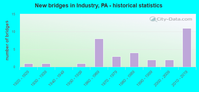
- New bridges - historical statistics
- 11920-1929
- 11930-1939
- 11950-1959
- 81960-1969
- 31970-1979
- 41980-1989
- 21990-1999
- 22000-2009
- 112010-2019

- Reconstructed bridges - Historical Statistics
- 11970-1979
- 01980-1989
- 11990-1999
- 22000-2009


- Bridge Condition - Deck
- 5.6%Excellent
- 22.2%Very good
- 33.3%Good
- 11.1%Satisfactory
- 22.2%Fair
- 5.6%Poor

- Bridge Condition - Superstructure
- 5.6%Excellent
- 16.7%Very good
- 38.9%Good
- 11.1%Satisfactory
- 22.2%Fair
- 5.6%Poor

- Bridge Condition - Substructure
- 5.6%Excellent
- 16.7%Very good
- 22.2%Good
- 33.3%Satisfactory
- 11.1%Fair
- 11.1%Poor

- Bridge Condition - Channel
- 6.7%Very good
- 6.7%Good
- 46.7%Satisfactory
- 26.7%Fair
- 13.3%Poor

- Bridge Condition - Culverts
- 60.0%Very good
- 20.0%Good
- 20.0%Fair
Find on map >> Show street view
Structure Number: 3429, Location: POTTER TWP (Lat: 40.653778, Lng: -80.350542), Route carried "on" structure: State highway 18, Year Built: 1932, Year Reconstructed: 1977, Status: Open, Structure Length: 6.98m (22.90ft), Average Daily Traffic: 6,100 (year 2022), Truck Traffic: 5%, Average Future Daily Traffic: 9,032 (year 2039), Design Load: HS 20, Features Intersected: RACCOON CREEK, Facility Carried by Structure: FRANKFORT ROAD
Minimum Vertical Clearance: 4.54m (14.90ft), Kilometerpoint: 25.534, Lanes on structure: 2, Owner: State Highway Agency, Approaching Roadway Width: 12.2m (40.0ft), Material/Design: Steel, Design/Construction: Truss - Thru, Number Of Spans In Main Unit: 1, Length of Maximum Span: 56.4m (185.0ft), Curb or Sidewalk Widths: Left: 1.8m (5.9ft), Right: 0.0m, Curb-To-Curb Width: 9.8m (32.2ft), Out-to-Out Width: 12.8m (42.0ft)
Condition: Deck: Fair, Superstructure: Poor, Substructure: Poor, Channel: Satisfactory, Operating Rating: 49.9 metric tons, Method Used To Determine Operating Rating: Allowable Stress (AS), Inventory Rating: 13.6 metric tons, Method Used To Determine Inventory Rating: Allowable Stress (AS), Structural Evaluation: High priority of corrective action, Deck Geometry: Meets minimum limits, Waterway Adequacy: Better than present minimum criteria, Approach Roadway Alignment: Equal to present desirable criteria, Length Of Structure Improvement: 5.60m (18.37ft), Designated Inspection Frequency: Every 24 months, Critical Feature Inspection Frequency: Every 12 months, Other Special Inspection Frequency: Every 12 months, Inspection Date: July 2020, Critical Feature Inspection Date: July 2021, Other Special Inspection Date: July 2021, Bridge Improvement Cost: $55,000, Roadway Improvement Cost: $161,000, Total Project Cost: $738,000, Deck Structure Type: Concrete Cast-file-Place, Wearing Surface/Protective System: Wearing Surface: Monolithic Concrete, Deck Protection: Epoxy Coated Reinforcing
Find on map >> Show street view
Structure Number: 3531, Location: I-376 NB O/T.R. 535 (Lat: 40.715669, Lng: -80.373794), Route carried "on" structure: Interstate 376, Year Built: 1973, Year Reconstructed: 2011, Status: Open, Structure Length: 4.15m (13.62ft), Average Daily Traffic: 11,802 (year 2021), Truck Traffic: 10%, Average Future Daily Traffic: 12,435 (year 2032), Design Load: HS 20, Features Intersected: T.R. 535 CHAPEL RD.
Minimum Vertical Clearance: 30+ m (98+ ft), Kilometerpoint: 5.177, Lanes on structure: 2, Lanes under structure: 2, Base Highway Network: Yes, Owner: State Highway Agency, Approaching Roadway Width: 13.4m (44.0ft), Skew: 10 degrees, Material/Design: Prestressed concrete, Design/Construction: Box Beam or Girders - Single/Spread, Number Of Spans In Main Unit: 3, Length of Maximum Span: 15.2m (49.9ft), Curb or Sidewalk Widths: Left: 0.2m (0.7ft), Right: 0.2m (0.7ft), Curb-To-Curb Width: 12.2m (40.0ft), Out-to-Out Width: 13.4m (44.0ft)
Condition: Deck: Good, Superstructure: Good, Substructure: Satisfactory, Operating Rating: 78.9 metric tons, Method Used To Determine Operating Rating: Load Factor (LF), Inventory Rating: 30.8 metric tons, Method Used To Determine Inventory Rating: Load Factor (LF), Structural Evaluation: Equal to present minimum criteria, Deck Geometry: Better than present minimum criteria, Underclear: Superior to present desirable criteria, Approach Roadway Alignment: Equal to present desirable criteria, Length Of Structure Improvement: 5.70m (18.70ft), Designated Inspection Frequency: Every 24 months, Inspection Date: April 2021, Bridge Improvement Cost: $69,000, Roadway Improvement Cost: $204,000, Total Project Cost: $935,000, Deck Structure Type: Concrete Cast-file-Place, Wearing Surface/Protective System: Wearing Surface: Monolithic Concrete, Deck Protection: Epoxy Coated Reinforcing
Find on map >> Show street view
Structure Number: 3562, Location: 1/2 MI NE OF SR 4034 (Lat: 40.649889, Lng: -80.410172), Route carried "on" structure: State highway 68, Year Built: 1924, Year Reconstructed: 2001, Status: Open, Structure Length: 0.61m (2.00ft), Average Daily Traffic: 6,837 (year 2020), Truck Traffic: 8%, Average Future Daily Traffic: 8,494 (year 2032), Design Load: HS 20, Features Intersected: SIX MILE RUN, Facility Carried by Structure: MIDLAND BEAVER RD
Minimum Vertical Clearance: 30+ m (98+ ft), Kilometerpoint: 10.406, Lanes on structure: 2, Base Highway Network: Yes, Owner: State Highway Agency, Approaching Roadway Width: 13.4m (44.0ft), Material/Design: Masonry, Design/Construction: Culvert, Number Of Spans In Main Unit: 1, Length of Maximum Span: 6.1m (20.0ft)
Condition: Channel: Poor, Culverts: Fair, Operating Rating: 49.0 metric tons, Method Used To Determine Operating Rating: Field evaluation and documented engineering judgment, Inventory Rating: 32.7 metric tons, Method Used To Determine Inventory Rating: Field evaluation and documented engineering judgment, Structural Evaluation: Somewhat better than minimum adequacy, Waterway Adequacy: Superior to present desirable criteria, Approach Roadway Alignment: Equal to present desirable criteria, Length Of Structure Improvement: 0.60m (1.97ft), Designated Inspection Frequency: Every 23 months, Inspection Date: April 2020, Bridge Improvement Cost: $18,000, Roadway Improvement Cost: $54,000, Total Project Cost: $246,000
Find on map >> Show street view
Structure Number: 3563, Location: 1/4 MI. EAST OF SR 4037 (Lat: 40.656706, Lng: -80.372656), Route carried "on" structure: State highway 68, Year Built: 1983, Status: Open, Structure Length: 23.77m (77.99ft), Average Daily Traffic: 10,550 (year 2022), Truck Traffic: 7%, Average Future Daily Traffic: 11,463 (year 2032), Design Load: HS 20, Features Intersected: NORFOLK RR.ACCESS ROAD, Facility Carried by Structure: MIDLAND-BEAVER RD
Minimum Vertical Clearance: 30+ m (98+ ft), Kilometerpoint: 14.127, Lanes on structure: 2, Lanes under structure: 2, Base Highway Network: Yes, Owner: State Highway Agency, Approaching Roadway Width: 13.4m (44.0ft), Skew: 9 degrees, Material/Design: Steel continuous, Design/Construction: Stringer/Multi-beam, Number Of Spans In Main Unit: 7, Length of Maximum Span: 39.6m (129.9ft), Curb or Sidewalk Widths: Left: 0.2m (0.7ft), Right: 0.2m (0.7ft), Curb-To-Curb Width: 13.4m (44.0ft), Out-to-Out Width: 14.3m (46.9ft)
Condition: Deck: Satisfactory, Superstructure: Good, Substructure: Fair, Operating Rating: 66.2 metric tons, Method Used To Determine Operating Rating: Load and Resistance Factor (LRFR), Inventory Rating: 50.8 metric tons, Method Used To Determine Inventory Rating: Load and Resistance Factor (LRFR), Structural Evaluation: Somewhat better than minimum adequacy, Deck Geometry: Equal to present minimum criteria, Underclear: Superior to present desirable criteria, Approach Roadway Alignment: Equal to present minimum criteria, Length Of Structure Improvement: 23.80m (78.08ft), Designated Inspection Frequency: Every 24 months, Critical Feature Inspection Frequency: Every 24 months, Inspection Date: July 2020, Critical Feature Inspection Date: July 2020, Deck Structure Type: Concrete Cast-file-Place, Wearing Surface/Protective System: Wearing Surface: Monolithic Concrete, Deck Protection: Epoxy Coated Reinforcing
Find on map >> Show street view
Structure Number: 3564, Location: 1 MILE N.E. OF SR 4037 (Lat: 40.664281, Lng: -80.357628), Route carried "on" structure: State highway 68, Year Built: 1991, Status: Open, Structure Length: 0.64m (2.10ft), Average Daily Traffic: 10,550 (year 2022), Truck Traffic: 7%, Average Future Daily Traffic: 11,463 (year 2032), Design Load: HS 20, Features Intersected: FOUR MILE RUN CREEK, Facility Carried by Structure: MIDLAND BEAVER RD
Minimum Vertical Clearance: 30+ m (98+ ft), Kilometerpoint: 15.788, Lanes on structure: 2, Base Highway Network: Yes, Owner: State Highway Agency, Approaching Roadway Width: 13.4m (44.0ft), Skew: 1 degrees, Material/Design: Concrete, Design/Construction: Culvert, Number Of Spans In Main Unit: 1, Length of Maximum Span: 6.4m (21.0ft), Curb-To-Curb Width: 19.5m (64.0ft), Out-to-Out Width: 23.5m (77.1ft)
Condition: Channel: Satisfactory, Culverts: Good, Operating Rating: 74.4 metric tons, Method Used To Determine Operating Rating: Load Factor (LF), Inventory Rating: 44.5 metric tons, Method Used To Determine Inventory Rating: Load Factor (LF), Structural Evaluation: Better than present minimum criteria, Deck Geometry: Superior to present desirable criteria, Waterway Adequacy: Equal to present desirable criteria, Approach Roadway Alignment: Equal to present desirable criteria, Length Of Structure Improvement: 0.60m (1.97ft), Designated Inspection Frequency: Every 48 months, Inspection Date: August 2018, Wearing Surface/Protective System: Wearing Surface: Bituminous, Deck Protection: Epoxy Coated Reinforcing
Find on map >> Show street view
Structure Number: 3566, Location: 100' WEST OF SEBRING RD. (Lat: 40.677683, Lng: -80.341161), Route carried "on" structure: State highway 68, Year Built: 1987, Status: Open, Structure Length: 7.47m (24.51ft), Average Daily Traffic: 10,550 (year 2022), Truck Traffic: 7%, Average Future Daily Traffic: 11,463 (year 2032), Design Load: HS 20, Features Intersected: NORFOLK SOUTHERN RAILWAY, Facility Carried by Structure: MIDLAND BEAVER RD
Minimum Vertical Clearance: 30+ m (98+ ft), Kilometerpoint: 17.799, Lanes on structure: 2, Base Highway Network: Yes, Owner: State Highway Agency, Approaching Roadway Width: 13.7m (44.9ft), Skew: 9 degrees, Material/Design: Prestressed concrete, Design/Construction: Stringer/Multi-beam, Number Of Spans In Main Unit: 3, Length of Maximum Span: 30.8m (101.0ft), Curb or Sidewalk Widths: Left: 0.2m (0.7ft), Right: 0.2m (0.7ft), Curb-To-Curb Width: 13.7m (44.9ft), Out-to-Out Width: 14.5m (47.6ft)
Condition: Deck: Good, Superstructure: Fair, Substructure: Satisfactory, Operating Rating: 74.4 metric tons, Method Used To Determine Operating Rating: Load Factor (LF), Inventory Rating: 23.6 metric tons, Method Used To Determine Inventory Rating: Load Factor (LF), Structural Evaluation: Somewhat better than minimum adequacy, Deck Geometry: Superior to present desirable criteria, Underclear: High priority of corrective action, Approach Roadway Alignment: Equal to present minimum criteria, Length Of Structure Improvement: 7.50m (24.61ft), Designated Inspection Frequency: Every 24 months, Inspection Date: August 2020, Bridge Improvement Cost: $201,000, Roadway Improvement Cost: $591,000, Total Project Cost: $2,710,000, Deck Structure Type: Concrete Cast-file-Place, Wearing Surface/Protective System: Wearing Surface: Monolithic Concrete, Deck Protection: Epoxy Coated Reinforcing
Find on map >> Show street view
Structure Number: 3595, Location: @ SHIPPINGPORT BRIDGE (Lat: 40.629317, Lng: -80.434667), Route carried "on" structure: State highway 168, Year Built: 1962, Status: Open, Structure Length: 1.74m (5.71ft), Average Daily Traffic: 4,878 (year 2021), Truck Traffic: 12%, Average Future Daily Traffic: 6,261 (year 2032), Design Load: HS 20, Features Intersected: SR 0068 TR 168, Facility Carried by Structure: SHIPPINGPORT HI RD
Minimum Vertical Clearance: 30+ m (98+ ft), Kilometerpoint: 21.393, Lanes on structure: 3, Lanes under structure: 1, Owner: State Highway Agency, Approaching Roadway Width: 25.6m (84.0ft), Skew: 3 degrees, Material/Design: Steel, Design/Construction: Stringer/Multi-beam, Number Of Spans In Main Unit: 1, Length of Maximum Span: 16.2m (53.1ft), Curb or Sidewalk Widths: Left: 0.5m (1.6ft), Right: 0.5m (1.6ft), Curb-To-Curb Width: 13.7m (44.9ft), Out-to-Out Width: 13.7m (44.9ft)
Condition: Deck: Very good, Superstructure: Very good, Substructure: Good, Operating Rating: 59.9 metric tons, Method Used To Determine Operating Rating: Load Factor (LF), Inventory Rating: 35.4 metric tons, Method Used To Determine Inventory Rating: Load Factor (LF), Structural Evaluation: Better than present minimum criteria, Deck Geometry: Somewhat better than minimum adequacy, Underclear: Equal to present minimum criteria, Approach Roadway Alignment: Somewhat better than minimum adequacy, Length Of Structure Improvement: 2.40m (7.87ft), Designated Inspection Frequency: Every 24 months, Inspection Date: March 2021, Bridge Improvement Cost: $11,000, Roadway Improvement Cost: $33,000, Total Project Cost: $151,000, Deck Structure Type: Concrete Cast-file-Place, Wearing Surface/Protective System: Wearing Surface: Latex Concrete
Find on map >> Show street view
Structure Number: 3711, Location: RACCOON TWP-FISHPOT RUN (Lat: 40.637044, Lng: -80.345950), Route carried "on" structure: State highway , Year Built: 1954, Year Reconstructed: 2006, Status: Open, Structure Length: 0.94m (3.08ft), Average Daily Traffic: 144 (year 2022), Truck Traffic: 9%, Average Future Daily Traffic: 78 (year 2032), Design Load: HS 20, Features Intersected: FISH POT RUN, Facility Carried by Structure: RACCOON CREEK RD
Minimum Vertical Clearance: 30+ m (98+ ft), Kilometerpoint: 1.875, Lanes on structure: 2, Owner: State Highway Agency, Approaching Roadway Width: 4.9m (16.1ft), Skew: 1 degrees, Material/Design: Concrete, Design/Construction: Slab, Number Of Spans In Main Unit: 1, Length of Maximum Span: 8.2m (26.9ft), Curb-To-Curb Width: 7.4m (24.3ft), Out-to-Out Width: 8.6m (28.2ft)
Condition: Deck: Good, Superstructure: Good, Substructure: Satisfactory, Channel: Satisfactory, Operating Rating: 71.7 metric tons, Method Used To Determine Operating Rating: Load Factor (LF), Inventory Rating: 43.5 metric tons, Method Used To Determine Inventory Rating: Load Factor (LF), Structural Evaluation: Equal to present minimum criteria, Deck Geometry: Somewhat better than minimum adequacy, Waterway Adequacy: Better than present minimum criteria, Approach Roadway Alignment: Equal to present desirable criteria, Length Of Structure Improvement: 0.90m (2.95ft), Designated Inspection Frequency: Every 24 months, Inspection Date: April 2021, Bridge Improvement Cost: $7,000, Roadway Improvement Cost: $25,000, Total Project Cost: $96,000, Wearing Surface/Protective System: Wearing Surface: Monolithic Concrete, Deck Protection: Epoxy Coated Reinforcing
Find on map >> Show street view
Structure Number: 3772, Location: 0.3 MI. EAST OF SR 4043 (Lat: 40.651386, Lng: -80.429656), Route carried "on" structure: State highway , Year Built: 1966, Status: Open, Structure Length: 0.82m (2.69ft), Average Daily Traffic: 501 (year 2022), Truck Traffic: 5%, Average Future Daily Traffic: 672 (year 2032), Design Load: HS 20, Features Intersected: WOLF RUN, Facility Carried by Structure: WOLF RUN RD
Minimum Vertical Clearance: 30+ m (98+ ft), Kilometerpoint: 1.086, Lanes on structure: 2, Owner: State Highway Agency, Approaching Roadway Width: 5.8m (19.0ft), Skew: 4 degrees, Material/Design: Concrete, Design/Construction: Slab, Number Of Spans In Main Unit: 1, Length of Maximum Span: 7.0m (23.0ft), Curb or Sidewalk Widths: Left: 0.5m (1.6ft), Right: 0.5m (1.6ft), Curb-To-Curb Width: 9.8m (32.2ft), Out-to-Out Width: 11.3m (37.1ft)
Condition: Deck: Fair, Superstructure: Fair, Substructure: Fair, Channel: Satisfactory, Operating Rating: 66.2 metric tons, Method Used To Determine Operating Rating: Load Factor (LF), Inventory Rating: 39.9 metric tons, Method Used To Determine Inventory Rating: Load Factor (LF), Structural Evaluation: Somewhat better than minimum adequacy, Deck Geometry: Equal to present minimum criteria, Waterway Adequacy: Better than present minimum criteria, Approach Roadway Alignment: Better than present minimum criteria, Length Of Structure Improvement: 0.80m (2.62ft), Designated Inspection Frequency: Every 24 months, Inspection Date: Febuary 2021, Bridge Improvement Cost: $4,000, Roadway Improvement Cost: $10,000, Total Project Cost: $48,000, Deck Structure Type: Concrete Cast-file-Place, Wearing Surface/Protective System: Wearing Surface: Bituminous
Find on map >> Show street view
Structure Number: 3773, Location: 0.5 MI. WEST OF SR 4041 (Lat: 40.651478, Lng: -80.427544), Route carried "on" structure: State highway , Year Built: 1962, Status: Open, Structure Length: 1.28m (4.20ft), Average Daily Traffic: 501 (year 2022), Truck Traffic: 5%, Average Future Daily Traffic: 672 (year 2032), Design Load: HS 20, Features Intersected: WOLF RUN, Facility Carried by Structure: WOLF RUN RD
Minimum Vertical Clearance: 30+ m (98+ ft), Kilometerpoint: 1.724, Lanes on structure: 2, Owner: State Highway Agency, Approaching Roadway Width: 10.1m (33.1ft), Skew: 6 degrees, Material/Design: Concrete, Design/Construction: Slab, Number Of Spans In Main Unit: 1, Length of Maximum Span: 11.6m (38.1ft), Curb or Sidewalk Widths: Left: 0.5m (1.6ft), Right: 0.5m (1.6ft), Curb-To-Curb Width: 10.1m (33.1ft), Out-to-Out Width: 11.3m (37.1ft)
Condition: Deck: Fair, Superstructure: Fair, Substructure: Poor, Channel: Poor, Operating Rating: 55.3 metric tons, Method Used To Determine Operating Rating: Load Factor (LF), Inventory Rating: 32.7 metric tons, Method Used To Determine Inventory Rating: Load Factor (LF), Structural Evaluation: Meets minimum limits, Deck Geometry: Equal to present minimum criteria, Waterway Adequacy: Better than present minimum criteria, Approach Roadway Alignment: Somewhat better than minimum adequacy, Length Of Structure Improvement: 1.30m (4.27ft), Designated Inspection Frequency: Every 24 months, Inspection Date: Febuary 2021, Bridge Improvement Cost: $5,000, Roadway Improvement Cost: $14,000, Total Project Cost: $64,000, Deck Structure Type: Concrete Cast-file-Place, Wearing Surface/Protective System: Wearing Surface: Bituminous
Find on map >> Show street view
Structure Number: 3774, Location: 300' N.W. OF SR 4041 (Lat: 40.650811, Lng: -80.423489), Route carried "on" structure: State highway , Year Built: 1966, Status: Open, Structure Length: 0.85m (2.79ft), Average Daily Traffic: 501 (year 2022), Truck Traffic: 5%, Average Future Daily Traffic: 672 (year 2032), Design Load: H 20, Features Intersected: WOLF RUN, Facility Carried by Structure: WOLF RUN RD
Minimum Vertical Clearance: 30+ m (98+ ft), Kilometerpoint: 1.724, Lanes on structure: 2, Owner: State Highway Agency, Approaching Roadway Width: 6.1m (20.0ft), Skew: 4 degrees, Material/Design: Concrete, Design/Construction: Slab, Number Of Spans In Main Unit: 1, Length of Maximum Span: 7.6m (24.9ft), Curb or Sidewalk Widths: Left: 0.5m (1.6ft), Right: 0.5m (1.6ft), Curb-To-Curb Width: 9.8m (32.2ft), Out-to-Out Width: 11.0m (36.1ft)
Condition: Deck: Good, Superstructure: Good, Substructure: Satisfactory, Channel: Fair, Operating Rating: 66.2 metric tons, Method Used To Determine Operating Rating: Load Factor (LF), Inventory Rating: 39.0 metric tons, Method Used To Determine Inventory Rating: Load Factor (LF), Structural Evaluation: Equal to present minimum criteria, Deck Geometry: Equal to present minimum criteria, Waterway Adequacy: Better than present minimum criteria, Approach Roadway Alignment: Equal to present minimum criteria, Length Of Structure Improvement: 0.90m (2.95ft), Designated Inspection Frequency: Every 24 months, Inspection Date: Febuary 2021, Deck Structure Type: Concrete Cast-file-Place, Wearing Surface/Protective System: Wearing Surface: Monolithic Concrete
Find on map >> Show street view
Structure Number: 3778, Location: 5430'N.OF TR68 (Lat: 40.665953, Lng: -80.392861), Route carried "on" structure: State highway , Year Built: 1961, Status: Open, Structure Length: 0.76m (2.49ft), Average Daily Traffic: 171 (year 2022), Truck Traffic: 2%, Average Future Daily Traffic: 375 (year 2032), Design Load: HS 20, Features Intersected: 6 MILE RUN, Facility Carried by Structure: PINE GROVE RD
Minimum Vertical Clearance: 30+ m (98+ ft), Kilometerpoint: 1.445, Lanes on structure: 2, Owner: State Highway Agency, Approaching Roadway Width: 6.7m (22.0ft), Skew: 3 degrees, Material/Design: Concrete, Design/Construction: Slab, Number Of Spans In Main Unit: 1, Length of Maximum Span: 7.0m (23.0ft), Curb or Sidewalk Widths: Left: 0.5m (1.6ft), Right: 0.5m (1.6ft), Curb-To-Curb Width: 11.1m (36.4ft), Out-to-Out Width: 12.8m (42.0ft)
Condition: Deck: Good, Superstructure: Good, Substructure: Good, Channel: Fair, Operating Rating: 51.7 metric tons, Method Used To Determine Operating Rating: Load Factor (LF), Inventory Rating: 30.8 metric tons, Method Used To Determine Inventory Rating: Load Factor (LF), Structural Evaluation: Better than present minimum criteria, Deck Geometry: Superior to present desirable criteria, Waterway Adequacy: Superior to present desirable criteria, Approach Roadway Alignment: Somewhat better than minimum adequacy, Length Of Structure Improvement: 1.50m (4.92ft), Designated Inspection Frequency: Every 24 months, Inspection Date: Febuary 2021, Deck Structure Type: Concrete Cast-file-Place, Wearing Surface/Protective System: Wearing Surface: Bituminous
Find on map >> Show street view
Structure Number: 3779, Location: 6000'N.OF INTER.W/TR68 (Lat: 40.667600, Lng: -80.392664), Route carried "on" structure: State highway , Year Built: 1961, Status: Open, Structure Length: 0.91m (2.99ft), Average Daily Traffic: 171 (year 2022), Truck Traffic: 2%, Average Future Daily Traffic: 375 (year 2032), Design Load: HS 20, Features Intersected: SIX MILE RUN, Facility Carried by Structure: PINE GROVE RD
Minimum Vertical Clearance: 30+ m (98+ ft), Kilometerpoint: 1.445, Lanes on structure: 2, Owner: State Highway Agency, Approaching Roadway Width: 12.8m (42.0ft), Skew: 3 degrees, Material/Design: Concrete, Design/Construction: Slab, Number Of Spans In Main Unit: 1, Length of Maximum Span: 7.9m (25.9ft), Curb or Sidewalk Widths: Left: 0.5m (1.6ft), Right: 0.5m (1.6ft), Curb-To-Curb Width: 11.1m (36.4ft), Out-to-Out Width: 12.8m (42.0ft)
Condition: Deck: Good, Superstructure: Good, Substructure: Good, Channel: Satisfactory, Operating Rating: 53.5 metric tons, Method Used To Determine Operating Rating: Load Factor (LF), Inventory Rating: 31.8 metric tons, Method Used To Determine Inventory Rating: Load Factor (LF), Structural Evaluation: Better than present minimum criteria, Deck Geometry: Superior to present desirable criteria, Waterway Adequacy: Superior to present desirable criteria, Approach Roadway Alignment: Equal to present minimum criteria, Length Of Structure Improvement: 1.60m (5.25ft), Designated Inspection Frequency: Every 24 months, Inspection Date: Febuary 2021, Deck Structure Type: Concrete Cast-file-Place, Wearing Surface/Protective System: Wearing Surface: Bituminous
Find on map >> Show street view
Structure Number: 385, Location: 004007 PINE GROVE RD (Lat: 40.674636, Lng: -80.401942), Route carried "on" structure: City street , Year Built: 1982, Status: Open, Structure Length: 1.22m (4.00ft), Average Daily Traffic: 125 (year 2021), Truck Traffic: 2%, Average Future Daily Traffic: 140 (year 2043), Design Load: HS 20, Features Intersected: SIX MILE RUN, Facility Carried by Structure: PINE GROVE RD
Minimum Vertical Clearance: 30+ m (98+ ft), Kilometerpoint: 0.000, Lanes on structure: 2, Owner: County Highway Agency, Approaching Roadway Width: 5.5m (18.0ft), Skew: 2 degrees, Material/Design: Prestressed concrete, Design/Construction: Box Beam or Girders - Multiple, Number Of Spans In Main Unit: 1, Length of Maximum Span: 11.6m (38.1ft), Curb-To-Curb Width: 8.2m (26.9ft), Out-to-Out Width: 8.6m (28.2ft)
Condition: Deck: Fair, Superstructure: Fair, Substructure: Good, Channel: Fair, Operating Rating: 61.7 metric tons, Method Used To Determine Operating Rating: Load Factor (LF), Inventory Rating: 34.5 metric tons, Method Used To Determine Inventory Rating: Load Factor (LF), Structural Evaluation: Somewhat better than minimum adequacy, Deck Geometry: Somewhat better than minimum adequacy, Waterway Adequacy: Better than present minimum criteria, Approach Roadway Alignment: Equal to present desirable criteria, Length Of Structure Improvement: 1.20m (3.94ft), Designated Inspection Frequency: Every 24 months, Inspection Date: July 2021, Deck Structure Type: Other, Wearing Surface/Protective System: Wearing Surface: Bituminous
Find on map >> Show street view
Structure Number: 31557, Location: 1.5 MI.W.OF CAIRNBROOK (Lat: 40.127861, Lng: -78.839186), Route carried "on" structure: State highway , Year Built: 1968, Status: Open, Structure Length: 1.19m (3.90ft), Average Daily Traffic: 453 (year 2020), Truck Traffic: 42%, Average Future Daily Traffic: 531 (year 2032), Design Load: HS 20+Mod, Features Intersected: MILLER RUN, Facility Carried by Structure: SR 1021
Minimum Vertical Clearance: 30+ m (98+ ft), Kilometerpoint: 9.146, Lanes on structure: 2, Owner: State Highway Agency, Approaching Roadway Width: 12.2m (40.0ft), Material/Design: Prestressed concrete, Design/Construction: Box Beam or Girders - Single/Spread, Number Of Spans In Main Unit: 1, Length of Maximum Span: 11.6m (38.1ft), Curb or Sidewalk Widths: Left: 0.2m (0.7ft), Right: 0.2m (0.7ft), Curb-To-Curb Width: 12.1m (39.7ft), Out-to-Out Width: 13.4m (44.0ft)
Condition: Deck: Poor, Superstructure: Satisfactory, Substructure: Satisfactory, Channel: Fair, Operating Rating: 75.3 metric tons, Method Used To Determine Operating Rating: Load Factor (LF), Inventory Rating: 34.5 metric tons, Method Used To Determine Inventory Rating: Load Factor (LF), Structural Evaluation: Equal to present minimum criteria, Deck Geometry: Better than present minimum criteria, Waterway Adequacy: Equal to present desirable criteria, Approach Roadway Alignment: Equal to present desirable criteria, Length Of Structure Improvement: 1.40m (4.59ft), Designated Inspection Frequency: Every 24 months, Inspection Date: June 2021, Bridge Improvement Cost: $50,000, Roadway Improvement Cost: $264,000, Total Project Cost: $680,000, Deck Structure Type: Concrete Cast-file-Place, Wearing Surface/Protective System: Wearing Surface: Monolithic Concrete
Find on map >> Show street view
Structure Number: 36385, Location: DERRY TOWNSHIP (Lat: 40.416697, Lng: -79.225472), Route carried "on" structure: State highway , Year Built: 1992, Status: Open, Structure Length: 2.59m (8.50ft), Average Daily Traffic: 2,148 (year 2022), Truck Traffic: 17%, Average Future Daily Traffic: 3,044 (year 2032), Design Load: HS 25 or greater, Features Intersected: Norfolk Southern Railway, Facility Carried by Structure: SR 1014
Minimum Vertical Clearance: 30+ m (98+ ft), Kilometerpoint: 3.178, Lanes on structure: 2, Owner: State Highway Agency, Approaching Roadway Width: 9.1m (29.9ft), Skew: 1 degrees, Material/Design: Prestressed concrete, Design/Construction: Box Beam or Girders - Multiple, Number Of Spans In Main Unit: 1, Length of Maximum Span: 25.3m (83.0ft), Curb or Sidewalk Widths: Left: 0.3m (1.0ft), Right: 0.3m (1.0ft), Curb-To-Curb Width: 9.1m (29.9ft), Out-to-Out Width: 10.2m (33.5ft)
Condition: Deck: Satisfactory, Superstructure: Satisfactory, Substructure: Satisfactory, Inventory Rating: 54.4 metric tons, Method Used To Determine Inventory Rating: Load Factor (LF), Structural Evaluation: Equal to present minimum criteria, Deck Geometry: Meets minimum limits, Underclear: High priority of corrective action, Approach Roadway Alignment: Somewhat better than minimum adequacy, Length Of Structure Improvement: 3.40m (11.15ft), Designated Inspection Frequency: Every 48 months, Inspection Date: July 2021, Deck Structure Type: Concrete Cast-file-Place, Wearing Surface/Protective System: Wearing Surface: Monolithic Concrete, Deck Protection: Epoxy Coated Reinforcing
Find on map >> Show street view
Structure Number: 41345, Location: 100' NE OF SR 4034 (Lat: 40.646072, Lng: -80.413506), Route carried "on" structure: State highway 68, Year Built: 2001, Status: Open, Structure Length: 0.67m (2.20ft), Average Daily Traffic: 6,837 (year 2020), Truck Traffic: 8%, Average Future Daily Traffic: 8,494 (year 2032), Design Load: HS 20, Features Intersected: WOLF RUN, Facility Carried by Structure: MIDLAND BEAVER RD
Minimum Vertical Clearance: 30+ m (98+ ft), Kilometerpoint: 10.406, Lanes on structure: 2, Base Highway Network: Yes, Owner: State Highway Agency, Approaching Roadway Width: 13.4m (44.0ft), Material/Design: Concrete, Design/Construction: Culvert, Number Of Spans In Main Unit: 1, Length of Maximum Span: 6.7m (22.0ft), Curb-To-Curb Width: 13.4m (44.0ft), Out-to-Out Width: 14.4m (47.2ft)
Condition: Channel: Satisfactory, Culverts: Very good, Operating Rating: 80.7 metric tons, Method Used To Determine Operating Rating: Load Factor (LF), Inventory Rating: 48.1 metric tons, Method Used To Determine Inventory Rating: Load Factor (LF), Structural Evaluation: Equal to present desirable criteria, Deck Geometry: Equal to present minimum criteria, Waterway Adequacy: Superior to present desirable criteria, Approach Roadway Alignment: Equal to present desirable criteria, Length Of Structure Improvement: 0.80m (2.62ft), Designated Inspection Frequency: Every 48 months, Inspection Date: August 2018
Find on map >> Show street view
Structure Number: 45704, Location: 200'NORTH OF SR 68 (Lat: 40.652525, Lng: -80.396919), Route carried "on" structure: State highway , Year Built: 2009, Status: Open, Structure Length: 0.94m (3.08ft), Average Daily Traffic: 895 (year 2020), Truck Traffic: 3%, Average Future Daily Traffic: 1,081 (year 2032), Design Load: HS 20, Features Intersected: SIX MILE RUN, Facility Carried by Structure: ENGLE ROAD
Minimum Vertical Clearance: 30+ m (98+ ft), Kilometerpoint: 6.236, Lanes on structure: 2, Owner: State Highway Agency, Approaching Roadway Width: 10.4m (34.1ft), Skew: 1 degrees, Material/Design: Concrete, Design/Construction: Culvert, Number Of Spans In Main Unit: 1, Length of Maximum Span: 9.4m (30.8ft)
Condition: Channel: Good, Culverts: Very good, Inventory Rating: 99.8 metric tons, Method Used To Determine Inventory Rating: Load Factor (LF), Structural Evaluation: Equal to present desirable criteria, Waterway Adequacy: Superior to present desirable criteria, Approach Roadway Alignment: Equal to present desirable criteria, Designated Inspection Frequency: Every 24 months, Inspection Date: Febuary 2021
Find on map >> Show street view
Structure Number: 46225, Location: AT SR 4041 INT (Lat: 40.649881, Lng: -80.421019), Route carried "on" structure: State highway , Year Built: 2010, Status: Open, Structure Length: 0.94m (3.08ft), Average Daily Traffic: 605 (year 2022), Truck Traffic: 6%, Average Future Daily Traffic: 781 (year 2032), Design Load: HL 93, Features Intersected: WOLF RUN, Facility Carried by Structure: SR 4034
Minimum Vertical Clearance: 30+ m (98+ ft), Kilometerpoint: 2.313, Lanes on structure: 2, Owner: State Highway Agency, Approaching Roadway Width: 5.8m (19.0ft), Skew: 4 degrees, Material/Design: Concrete, Design/Construction: Culvert, Number Of Spans In Main Unit: 1, Length of Maximum Span: 9.4m (30.8ft), Curb or Sidewalk Widths: Left: 0.5m (1.6ft), Right: 0.5m (1.6ft), Curb-To-Curb Width: 7.9m (25.9ft), Out-to-Out Width: 12.7m (41.7ft)
Condition: Channel: Satisfactory, Culverts: Very good, Inventory Rating: 88.9 metric tons, Method Used To Determine Inventory Rating: Load Factor (LF), Structural Evaluation: Equal to present desirable criteria, Deck Geometry: Somewhat better than minimum adequacy, Waterway Adequacy: Better than present minimum criteria, Approach Roadway Alignment: Equal to present desirable criteria, Designated Inspection Frequency: Every 24 months, Inspection Date: Febuary 2021, Wearing Surface/Protective System: Wearing Surface: Bituminous, Deck Protection: Epoxy Coated Reinforcing
Find on map >> Show street view
Structure Number: 46284, Location: BRIGHTON TWP OVER 376 (Lat: 40.701175, Lng: -80.364989), Route carried "on" structure: State highway , Year Built: 2010, Status: Open, Structure Length: 6.86m (22.51ft), Average Daily Traffic: 2,554 (year 2020), Truck Traffic: 6%, Average Future Daily Traffic: 4,222 (year 2032), Design Load: HL 93, Features Intersected: SR 0376 EB WB, Facility Carried by Structure: BRIGHTON RD
Minimum Vertical Clearance: 30+ m (98+ ft), Kilometerpoint: 0.608, Lanes on structure: 2, Lanes under structure: 4, Owner: State Highway Agency, Approaching Roadway Width: 21.9m (71.9ft), Skew: 20 degrees, Material/Design: Prestressed concrete continuous, Design/Construction: Box Beam or Girders - Single/Spread, Number Of Spans In Main Unit: 4, Length of Maximum Span: 20.7m (67.9ft), Curb-To-Curb Width: 22.0m (72.2ft), Out-to-Out Width: 23.2m (76.1ft)
Condition: Deck: Very good, Superstructure: Very good, Substructure: Very good, Operating Rating: 58.1 metric tons, Method Used To Determine Operating Rating: Load and Resistance Factor (LRFR), Inventory Rating: 43.5 metric tons, Method Used To Determine Inventory Rating: Load and Resistance Factor (LRFR), Structural Evaluation: Equal to present desirable criteria, Deck Geometry: Superior to present desirable criteria, Underclear: Equal to present minimum criteria, Approach Roadway Alignment: Equal to present desirable criteria, Designated Inspection Frequency: Every 24 months, Inspection Date: Febuary 2021, Deck Structure Type: Concrete Cast-file-Place, Wearing Surface/Protective System: Wearing Surface: Monolithic Concrete, Deck Protection: Epoxy Coated Reinforcing
Find on map >> Show street view
Structure Number: 46781, Location: SR 4028 OVER SR 0060 (Lat: 40.696389, Lng: -80.361111), Route carried "on" structure: State highway , Year Built: 2011, Status: Open, Structure Length: 8.20m (26.90ft), Average Daily Traffic: 3,539 (year 2022), Truck Traffic: 3%, Average Future Daily Traffic: 6,800 (year 2032), Design Load: HL 93, Features Intersected: SR 0376 EB WB, Facility Carried by Structure: TUSCARAWAS ROAD
Minimum Vertical Clearance: 30+ m (98+ ft), Kilometerpoint: 11.788, Lanes on structure: 2, Lanes under structure: 4, Owner: State Highway Agency, Approaching Roadway Width: 14.6m (47.9ft), Material/Design: Prestressed concrete continuous, Design/Construction: Box Beam or Girders - Single/Spread, Number Of Spans In Main Unit: 4, Length of Maximum Span: 20.7m (67.9ft), Curb or Sidewalk Widths: Left: 0.2m (0.7ft), Right: 0.2m (0.7ft), Curb-To-Curb Width: 13.4m (44.0ft), Out-to-Out Width: 14.4m (47.2ft)
Condition: Deck: Very good, Superstructure: Very good, Substructure: Very good, Operating Rating: 58.0 metric tons, Method Used To Determine Operating Rating: Assigned ratings based on Load and Resistance Factor Design (LRFD) reported by rating factor (RF) using HL93 loadings, Inventory Rating: 35.0 metric tons, Method Used To Determine Inventory Rating: Assigned ratings based on Load and Resistance Factor Design (LRFD) reported by rating factor (RF) using HL93 loadings, Structural Evaluation: Equal to present desirable criteria, Deck Geometry: Better than present minimum criteria, Underclear: Equal to present minimum criteria, Approach Roadway Alignment: Equal to present desirable criteria, Designated Inspection Frequency: Every 24 months, Inspection Date: September 2021, Deck Structure Type: Concrete Cast-file-Place, Wearing Surface/Protective System: Wearing Surface: Monolithic Concrete, Deck Protection: Epoxy Coated Reinforcing
Find on map >> Show street view
Structure Number: 46917, Location: AT SR 3019 INTERSECTION (Lat: 40.628031, Lng: -80.337239), Route carried "on" structure: State highway , Year Built: 2011, Status: Open, Structure Length: 4.33m (14.21ft), Average Daily Traffic: 1,556 (year 2022), Truck Traffic: 6%, Average Future Daily Traffic: 2,987 (year 2032), Design Load: HL 93, Features Intersected: RACCOON CREEK, Facility Carried by Structure: MOFFET MILL ROAD
Minimum Vertical Clearance: 30+ m (98+ ft), Kilometerpoint: 5.049, Lanes on structure: 2, Owner: State Highway Agency, Approaching Roadway Width: 7.3m (24.0ft), Material/Design: Steel, Design/Construction: Stringer/Multi-beam, Number Of Spans In Main Unit: 1, Length of Maximum Span: 42.1m (138.1ft), Curb-To-Curb Width: 7.3m (24.0ft), Out-to-Out Width: 8.3m (27.2ft)
Condition: Deck: Very good, Superstructure: Good, Substructure: Very good, Channel: Very good, Operating Rating: 67.1 metric tons, Method Used To Determine Operating Rating: Assigned ratings based on Load and Resistance Factor Design (LRFD) reported by rating factor (RF) using HL93 loadings, Inventory Rating: 42.1 metric tons, Method Used To Determine Inventory Rating: Assigned ratings based on Load and Resistance Factor Design (LRFD) reported by rating factor (RF) using HL93 loadings, Structural Evaluation: Better than present minimum criteria, Deck Geometry: Meets minimum limits, Waterway Adequacy: Equal to present desirable criteria, Approach Roadway Alignment: Meets minimum limits, Designated Inspection Frequency: Every 24 months, Inspection Date: April 2021, Deck Structure Type: Concrete Cast-file-Place, Wearing Surface/Protective System: Wearing Surface: Monolithic Concrete, Deck Protection: Epoxy Coated Reinforcing
Find on map >> Show street view
Structure Number: 54266, Location: 0.4 Mi. W of Brighton Rd. (Lat: 40.708067, Lng: -80.374058), Route carried "on" structure: State highway , Year Built: 2019, Status: Open, Structure Length: 11.37m (37.30ft), Average Daily Traffic: 2,520 (year 2021), Truck Traffic: 7%, Average Future Daily Traffic: 3,000 (year 2039), Design Load: HL 93, Features Intersected: SR 0376, Facility Carried by Structure: Dutch Ridge Road
Minimum Vertical Clearance: 30+ m (98+ ft), Kilometerpoint: 2.322, Lanes on structure: 2, Lanes under structure: 4, Owner: State Highway Agency, Approaching Roadway Width: 10.4m (34.1ft), Skew: 3 degrees, Material/Design: Prestressed concrete continuous, Design/Construction: Stringer/Multi-beam, Number Of Spans In Main Unit: 4, Length of Maximum Span: 28.7m (94.2ft), Curb or Sidewalk Widths: Left: 0.2m (0.7ft), Right: 0.2m (0.7ft), Curb-To-Curb Width: 12.2m (40.0ft), Out-to-Out Width: 13.2m (43.3ft)
Condition: Deck: Excellent, Superstructure: Excellent, Substructure: Excellent, Operating Rating: 54.4 metric tons, Method Used To Determine Operating Rating: Assigned ratings based on Load and Resistance Factor Design (LRFD) reported by rating factor (RF) using HL93 loadings, Inventory Rating: 40.2 metric tons, Method Used To Determine Inventory Rating: Assigned ratings based on Load and Resistance Factor Design (LRFD) reported by rating factor (RF) using HL93 loadings, Structural Evaluation: Superior to present desirable criteria, Deck Geometry: Equal to present minimum criteria, Underclear: High priority of corrective action, Approach Roadway Alignment: Equal to present desirable criteria, Designated Inspection Frequency: Every 24 months, Inspection Date: September 2021, Deck Structure Type: Concrete Cast-file-Place, Wearing Surface/Protective System: Wearing Surface: Monolithic Concrete, Deck Protection: Epoxy Coated Reinforcing
Find on map >> Show street view
Structure Number: 3531, Location: I-376 NB O/T.R. 535 (Lat: 40.715669, Lng: -80.373794), Route carried "under" structure: City street , Year Built: 1973, Structure Length: 0. m, Average Daily Traffic: 100 (year 1993), Truck Traffic: 2%, Features Intersected: T.R. 535 CHAPEL RD., Facility Carried by Structure: SR 0376 WB
Minimum Vertical Clearance: 5.92m (19.42ft), Kilometerpoint: 0.000, Lanes on structure: 2, Lanes under structure: 2, Material/Design: Prestressed concrete, Design/Construction: Box Beam or Girders - Single/Spread, Length of Maximum Span: 15.2m (49.9ft)
Find on map >> Show street view
Structure Number: 3532, Location: I-376 SB Over T.R. 535 (Lat: 40.715917, Lng: -80.373914), Route carried "under" structure: City street , Year Built: 1973, Structure Length: 0. m, Average Daily Traffic: 100 (year 2005), Truck Traffic: 8%, Features Intersected: T.R. 535 Chapel Rd, Facility Carried by Structure: SR 0376 EB
Minimum Vertical Clearance: 4.67m (15.32ft), Kilometerpoint: 0.000, Lanes on structure: 2, Lanes under structure: 2, Material/Design: Prestressed concrete, Design/Construction: Box Beam or Girders - Single/Spread, Length of Maximum Span: 15.2m (49.9ft)
Find on map >> Show street view
Structure Number: 3563, Location: 1/4 MI. EAST OF SR 4037 (Lat: 40.656706, Lng: -80.372656), Route carried "under" structure: ServiceOther road , Year Built: 1983, Structure Length: 0. m, Average Daily Traffic: 10 (year 2006), Truck Traffic: 1%, Features Intersected: NORFOLK RR.ACCESS ROAD, Facility Carried by Structure: MIDLAND-BEAVER RD
Minimum Vertical Clearance: 7.62m (25.00ft), Kilometerpoint: 0.000, Lanes on structure: 2, Lanes under structure: 2, Material/Design: Steel continuous, Design/Construction: Stringer/Multi-beam, Length of Maximum Span: 39.6m (129.9ft)
Find on map >> Show street view
Structure Number: 3595, Location: @ SHIPPINGPORT BRIDGE (Lat: 40.629317, Lng: -80.434667), Route carried "under" structure: State highway 68, Year Built: 1962, Structure Length: 0. m, Average Daily Traffic: 4,192 (year 2021), Truck Traffic: 16%, Features Intersected: SR 0068 TR 168, Facility Carried by Structure: SHIPPINGPORT HI RD
Minimum Vertical Clearance: 4.50m (14.76ft), Kilometerpoint: 7.360, Lanes on structure: 3, Lanes under structure: 1, Material/Design: Steel, Design/Construction: Stringer/Multi-beam, Length of Maximum Span: 16.2m (53.1ft)
Find on map >> Show street view
Structure Number: 46284, Location: BRIGHTON TWP OVER 376 (Lat: 40.701175, Lng: -80.364989), Route carried "under" structure: Interstate 376, Year Built: 2010, Structure Length: 0. m, Average Daily Traffic: 8,133 (year 2020), Truck Traffic: 14%, Features Intersected: SR 0376 EB WB, Facility Carried by Structure: BRIGHTON RD
Minimum Vertical Clearance: 5.36m (17.59ft), Kilometerpoint: 7.582, Lanes on structure: 2, Lanes under structure: 2, Material/Design: Prestressed concrete continuous, Design/Construction: Box Beam or Girders - Single/Spread, Length of Maximum Span: 20.7m (67.9ft)
Find on map >> Show street view
Structure Number: 46284, Location: BRIGHTON TWP OVER 376 (Lat: 40.701175, Lng: -80.364989), Route carried "under" structure: Interstate 376, Year Built: 2010, Structure Length: 0. m, Average Daily Traffic: 7,899 (year 2020), Truck Traffic: 16%, Features Intersected: SR 0376 EB WB, Facility Carried by Structure: BRIGHTON RD
Minimum Vertical Clearance: 5.36m (17.59ft), Kilometerpoint: 7.545, Lanes on structure: 2, Lanes under structure: 2, Material/Design: Prestressed concrete continuous, Design/Construction: Box Beam or Girders - Single/Spread, Length of Maximum Span: 20.7m (67.9ft)
Find on map >> Show street view
Structure Number: 46781, Location: SR 4028 OVER SR 0060 (Lat: 40.696389, Lng: -80.361111), Route carried "under" structure: Interstate 376, Year Built: 2011, Structure Length: 0. m, Average Daily Traffic: 8,133 (year 2020), Truck Traffic: 14%, Features Intersected: SR 0376 EB WB, Facility Carried by Structure: TUSCARAWAS ROAD
Minimum Vertical Clearance: 6.20m (20.34ft), Kilometerpoint: 7.582, Lanes on structure: 2, Lanes under structure: 2, Material/Design: Prestressed concrete continuous, Design/Construction: Box Beam or Girders - Single/Spread, Length of Maximum Span: 20.7m (67.9ft)
Find on map >> Show street view
Structure Number: 46781, Location: SR 4028 OVER SR 0060 (Lat: 40.696389, Lng: -80.361111), Route carried "under" structure: Interstate 376, Year Built: 2011, Structure Length: 0. m, Average Daily Traffic: 7,899 (year 2020), Truck Traffic: 16%, Features Intersected: SR 0376 EB WB, Facility Carried by Structure: TUSCARAWAS ROAD
Minimum Vertical Clearance: 5.54m (18.18ft), Kilometerpoint: 7.545, Lanes on structure: 2, Lanes under structure: 2, Material/Design: Prestressed concrete continuous, Design/Construction: Box Beam or Girders - Single/Spread, Length of Maximum Span: 20.7m (67.9ft)
Find on map >> Show street view
Structure Number: 54266, Location: 0.4 Mi. W of Brighton Rd. (Lat: 40.708067, Lng: -80.374058), Route carried "under" structure: Interstate 376, Year Built: 2019, Structure Length: 0. m, Average Daily Traffic: 11,802 (year 2021), Truck Traffic: 10%, Features Intersected: SR 0376, Facility Carried by Structure: Dutch Ridge Road
Minimum Vertical Clearance: 10.84m (35.56ft), Kilometerpoint: 5.969, Lanes on structure: 2, Lanes under structure: 2, Material/Design: Prestressed concrete continuous, Design/Construction: Stringer/Multi-beam, Length of Maximum Span: 28.7m (94.2ft)
Find on map >> Show street view
Structure Number: 54266, Location: 0.4 Mi. W of Brighton Rd. (Lat: 40.708067, Lng: -80.374058), Route carried "under" structure: Interstate 376, Year Built: 2019, Structure Length: 0. m, Average Daily Traffic: 11,829 (year 2021), Truck Traffic: 11%, Features Intersected: SR 0376, Facility Carried by Structure: Dutch Ridge Road
Minimum Vertical Clearance: 10.84m (35.56ft), Kilometerpoint: 5.972, Lanes on structure: 2, Lanes under structure: 2, Material/Design: Prestressed concrete continuous, Design/Construction: Stringer/Multi-beam, Length of Maximum Span: 28.7m (94.2ft)