Bridge Statistics for Indian Head Park, Illinois (IL)
Condition, Traffic, Stress, Structural Evaluation, Project Costs
- National Bridge Inventory (NBI) Statistics
- 16Number of bridges
- 197ft / 59.5mTotal length
- $4,567,000Total costs
- 771,275Total average daily traffic
- 114,136Total average daily truck traffic
- National Bridge Inventory (NBI) Registered Bridges for Indian Head Park
- No street view available for this location
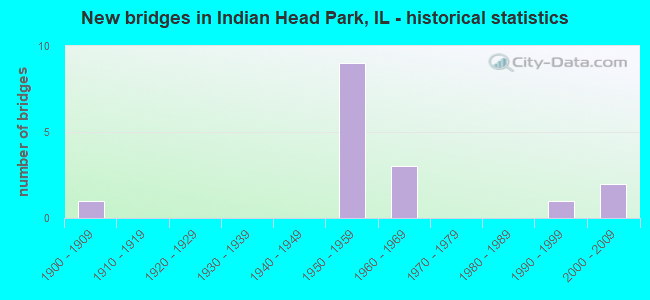
- New bridges - historical statistics
- 11900-1909
- 91950-1959
- 31960-1969
- 11990-1999
- 22000-2009

- Reconstructed bridges - Historical Statistics
- 11990-1999
- 02000-2009
- 02010-2019
- 12020-2022


- Bridge Condition - Deck
- 22.2%Good
- 55.6%Satisfactory
- 22.2%Poor

- Bridge Condition - Superstructure
- 22.2%Good
- 66.7%Satisfactory
- 11.1%Fair

- Bridge Condition - Substructure
- 33.3%Good
- 33.3%Satisfactory
- 33.3%Fair

- Bridge Condition - Channel
- 80.0%Good
- 20.0%Fair
Find on map >> Show street view
Structure Number: 160003, Location: 1.5 M W US 45 (Lat: 41.760669, Lng: -87.896600), Route carried "on" structure: Interstate 55, Year Built: 1963, Year Reconstructed: 1996, Status: Open, Structure Length: 8.61m (28.25ft), Average Daily Traffic: 145,000 (year 2021), Truck Traffic: 9%, Average Future Daily Traffic: 174,585 (year 2032), Design Load: HS 20, Features Intersected: WOLF RD & FLAG CR
Minimum Vertical Clearance: 30+ m (98+ ft), Kilometerpoint: 446.516, Lanes on structure: 8, Lanes under structure: 2, Base Highway Network: Yes, Owner: State Highway Agency, Approaching Roadway Width: 41.5m (136.2ft), Skew: 30 degrees, Material/Design: Steel continuous, Design/Construction: Stringer/Multi-beam, Number Of Spans In Main Unit: 5, Length of Maximum Span: 20.6m (67.6ft), Curb-To-Curb Width: 41.5m (136.2ft), Out-to-Out Width: 43.3m (142.1ft)
Condition: Deck: Satisfactory, Superstructure: Satisfactory, Substructure: Satisfactory, Channel: Good, Operating Rating: 89.1 metric tons, Method Used To Determine Operating Rating: Load Factor (LF) rating reported by rating factor (RF) method using MS18 loading, Inventory Rating: 59.0 metric tons, Method Used To Determine Inventory Rating: Load Factor (LF) rating reported by rating factor (RF) method using MS18 loading, Structural Evaluation: Equal to present minimum criteria, Deck Geometry: Superior to present desirable criteria, Underclear: Equal to present minimum criteria, Waterway Adequacy: Superior to present desirable criteria, Approach Roadway Alignment: Equal to present desirable criteria, Designated Inspection Frequency: Every 24 months, Inspection Date: November 2020, Deck Structure Type: Concrete Cast-file-Place, Wearing Surface/Protective System: Deck Protection: Epoxy Coated Reinforcing
Find on map >> Show street view
Structure Number: 160393, Location: 0.8 M NE DUPAGE CO (Lat: 41.763172, Lng: -87.901861), Route carried "on" structure: Other road , Year Built: 1959, Year Reconstructed: 2020, Status: Open, Structure Length: 2.89m (9.48ft), Average Daily Traffic: 12,500 (year 2018), Truck Traffic: 9%, Average Future Daily Traffic: 12,875 (year 2032), Design Load: HS 20+Mod, Features Intersected: FLAG CREEK, Facility Carried by Structure: JOLIET RD
Minimum Vertical Clearance: 30+ m (98+ ft), Kilometerpoint: 0.772, Lanes on structure: 5, Base Highway Network: Yes, Owner: State Highway Agency, Approaching Roadway Width: 19.8m (65.0ft), Skew: 30 degrees, Material/Design: Prestressed concrete, Design/Construction: Stringer/Multi-beam, Number Of Spans In Main Unit: 2, Length of Maximum Span: 13.7m (44.9ft), Curb-To-Curb Width: 20.7m (67.9ft), Out-to-Out Width: 22.4m (73.5ft)
Condition: Deck: Poor, Superstructure: Satisfactory, Substructure: Fair, Channel: Good, Operating Rating: 90.1 metric tons, Method Used To Determine Operating Rating: Load Factor (LF) rating reported by rating factor (RF) method using MS18 loading, Inventory Rating: 48.3 metric tons, Method Used To Determine Inventory Rating: Load Factor (LF) rating reported by rating factor (RF) method using MS18 loading, Structural Evaluation: Somewhat better than minimum adequacy, Deck Geometry: Somewhat better than minimum adequacy, Waterway Adequacy: Better than present minimum criteria, Approach Roadway Alignment: Better than present minimum criteria, Designated Inspection Frequency: Every 24 months, Inspection Date: Febuary 2020, Deck Structure Type: Concrete Cast-file-Place, Wearing Surface/Protective System: Wearing Surface: Other
Find on map >> Show street view
Structure Number: 161063, Location: 1.5 M W US 45 (Lat: 41.761103, Lng: -87.897014), Route carried "on" structure: City street , Year Built: 1963, Status: Open, Structure Length: 2.69m (8.83ft), Average Daily Traffic: 375 (year 2018), Truck Traffic: 37%, Average Future Daily Traffic: 310 (year 2032), Design Load: HS 15, Features Intersected: FLAG CREEK, Facility Carried by Structure: 70TH PLACE
Minimum Vertical Clearance: 30+ m (98+ ft), Kilometerpoint: 0.354, Lanes on structure: 2, Owner: State Highway Agency, Approaching Roadway Width: 9.1m (29.9ft), Material/Design: Prestressed concrete, Design/Construction: Stringer/Multi-beam, Number Of Spans In Main Unit: 1, Length of Maximum Span: 25.3m (83.0ft), Curb-To-Curb Width: 8.6m (28.2ft), Out-to-Out Width: 9.8m (32.2ft)
Condition: Deck: Good, Superstructure: Good, Substructure: Good, Channel: Good, Operating Rating: 97.2 metric tons, Method Used To Determine Operating Rating: Load Factor (LF) rating reported by rating factor (RF) method using MS18 loading, Inventory Rating: 47.0 metric tons, Method Used To Determine Inventory Rating: Load Factor (LF) rating reported by rating factor (RF) method using MS18 loading, Structural Evaluation: Better than present minimum criteria, Deck Geometry: Equal to present minimum criteria, Waterway Adequacy: Better than present minimum criteria, Approach Roadway Alignment: Better than present minimum criteria, Length Of Structure Improvement: 3.44m (11.29ft), Designated Inspection Frequency: Every 24 months, Inspection Date: October 2021, Bridge Improvement Cost: $371,000, Roadway Improvement Cost: $37,000, Total Project Cost: $557,000, Deck Structure Type: Concrete Cast-file-Place, Wearing Surface/Protective System: Wearing Surface: Latex Concrete
Find on map >> Show street view
Structure Number: 162687, Location: 0.3 M NW I-55 (Lat: 41.762136, Lng: -87.903544), Route carried "on" structure: Other road , Year Built: 2002, Status: Open, Structure Length: 6.05m (19.85ft), Average Daily Traffic: 12,400 (year 2021), Average Future Daily Traffic: 13,596 (year 2032), Design Load: HS 20, Features Intersected: JOLIET RD, Facility Carried by Structure: I-294 RAMPS I-55
Minimum Vertical Clearance: 30+ m (98+ ft), Kilometerpoint: 1.062, Lanes on structure: 4, Lanes under structure: 5, Base Highway Network: Yes (Inventory Route: 10055040, Subroute: 70), Owner: State Highway Agency, Approaching Roadway Width: 21.9m (71.9ft), Skew: 1 degrees, Material/Design: Steel, Design/Construction: Stringer/Multi-beam, Number Of Spans In Main Unit: 1, Number Of Approach Spans: 2, Length of Maximum Span: 39.9m (130.9ft), Curb-To-Curb Width: 21.9m (71.9ft), Out-to-Out Width: 23.6m (77.4ft)
Condition: Deck: Good, Superstructure: Good, Substructure: Good, Operating Rating: 83.3 metric tons, Method Used To Determine Operating Rating: Load Factor (LF) rating reported by rating factor (RF) method using MS18 loading, Inventory Rating: 49.9 metric tons, Method Used To Determine Inventory Rating: Load Factor (LF) rating reported by rating factor (RF) method using MS18 loading, Structural Evaluation: Better than present minimum criteria, Deck Geometry: Better than present minimum criteria, Underclear: High priority of corrective action, Approach Roadway Alignment: Equal to present desirable criteria, Designated Inspection Frequency: Every 24 months, Inspection Date: September 2020, Deck Structure Type: Concrete Cast-file-Place, Wearing Surface/Protective System: Deck Protection: Epoxy Coated Reinforcing
Find on map >> Show street view
Structure Number: 163016, Location: 0.9 M N 79TH P10 (Lat: 41.759919, Lng: -87.896581), Route carried "on" structure: Other road , Year Built: 1900, Status: Open, Structure Length: 3.07m (10.07ft), Average Daily Traffic: 10,900 (year 2018), Truck Traffic: 26%, Average Future Daily Traffic: 8,858 (year 2032), Design Load: HS 20, Features Intersected: FLAG CREEK, Facility Carried by Structure: WOLF RD
Minimum Vertical Clearance: 30+ m (98+ ft), Kilometerpoint: 14.435, Lanes on structure: 2, Owner: County Highway Agency, Approaching Roadway Width: 11.0m (36.1ft), Skew: 3 degrees, Material/Design: Prestressed concrete, Design/Construction: Stringer/Multi-beam, Number Of Spans In Main Unit: 2, Length of Maximum Span: 14.8m (48.6ft), Curb or Sidewalk Widths: Left: 1.5m (4.9ft), Right: 1.5m (4.9ft), Curb-To-Curb Width: 9.1m (29.9ft), Out-to-Out Width: 12.8m (42.0ft)
Condition: Deck: Poor, Superstructure: Fair, Substructure: Good, Channel: Good, Operating Rating: 41.8 metric tons, Method Used To Determine Operating Rating: Load Factor (LF) rating reported by rating factor (RF) method using MS18 loading, Inventory Rating: 21.7 metric tons, Method Used To Determine Inventory Rating: Load Factor (LF) rating reported by rating factor (RF) method using MS18 loading, Structural Evaluation: Somewhat better than minimum adequacy, Deck Geometry: High priority of corrective action, Waterway Adequacy: Equal to present desirable criteria, Approach Roadway Alignment: Equal to present desirable criteria, Length Of Structure Improvement: 4.72m (15.49ft), Designated Inspection Frequency: Every 24 months, Underwater Inspection Frequency: Every 60 months, Inspection Date: June 2021, Underwater Inspection Date: August 2020, Bridge Improvement Cost: $477,000, Roadway Improvement Cost: $48,000, Total Project Cost: $716,000, Deck Structure Type: Concrete Cast-file-Place, Wearing Surface/Protective System: Wearing Surface: Latex Concrete
Find on map >> Show street view
Structure Number: 163245, Location: 0.2M.N.OF I-55 (Lat: 41.761250, Lng: -87.896633), Route carried "on" structure: Other road , Year Built: 1991, Status: Open, Structure Length: 0.72m (2.36ft), Average Daily Traffic: 10,900 (year 2018), Truck Traffic: 26%, Average Future Daily Traffic: 8,858 (year 2032), Design Load: HS 20, Features Intersected: RELOC.FLAG CREEK, Facility Carried by Structure: WOLF RD.
Minimum Vertical Clearance: 30+ m (98+ ft), Kilometerpoint: 14.258, Lanes on structure: 2, Base Highway Network: Yes, Owner: County Highway Agency, Approaching Roadway Width: 7.3m (24.0ft), Skew: 2 degrees, Material/Design: Concrete, Design/Construction: Culvert, Number Of Spans In Main Unit: 2, Length of Maximum Span: 3.0m (9.8ft)
Condition: Channel: Fair, Culverts: Satisfactory, Operating Rating: 44.4 metric tons, Method Used To Determine Operating Rating: Assigned rating based on Load Factor Design (LFD) reported by rating factor (RF) using MS18 loading, Inventory Rating: 32.4 metric tons, Method Used To Determine Inventory Rating: Assigned rating based on Load Factor Design (LFD) reported by rating factor (RF) using MS18 loading, Structural Evaluation: Equal to present minimum criteria, Waterway Adequacy: Equal to present desirable criteria, Approach Roadway Alignment: Equal to present desirable criteria, Designated Inspection Frequency: Every 24 months, Inspection Date: June 2020, Wearing Surface/Protective System: Wearing Surface: Bituminous
Find on map >> Show street view
Structure Number: 169818, Location: 0.2 M NW I55 P10 (Lat: 41.762175, Lng: -87.897008), Route carried "on" structure: Interstate 294, Year Built: 1958, Status: Open, Structure Length: 2.47m (8.10ft), Average Daily Traffic: 64,850 (year 2021), Truck Traffic: 22%, Average Future Daily Traffic: 59,586 (year 2032), Features Intersected: WOLF RD
Minimum Vertical Clearance: 30+ m (98+ ft), Kilometerpoint: 47.700, Lanes on structure: 3, Lanes under structure: 2, Base Highway Network: Yes, Toll: On toll road, Owner: State Toll Authority, Approaching Roadway Width: 15.8m (51.8ft), Skew: 3 degrees, Material/Design: Prestressed concrete, Design/Construction: Stringer/Multi-beam, Number Of Spans In Main Unit: 1, Length of Maximum Span: 23.5m (77.1ft), Curb-To-Curb Width: 14.3m (46.9ft), Out-to-Out Width: 18.6m (61.0ft)
Condition: Deck: Satisfactory, Superstructure: Satisfactory, Substructure: Satisfactory, Operating Rating: 97.2 metric tons, Method Used To Determine Operating Rating: Load Factor (LF) rating reported by rating factor (RF) method using MS18 loading, Inventory Rating: 58.3 metric tons, Method Used To Determine Inventory Rating: Load Factor (LF) rating reported by rating factor (RF) method using MS18 loading, Structural Evaluation: Equal to present minimum criteria, Deck Geometry: Meets minimum limits, Underclear: Meets minimum limits, Approach Roadway Alignment: Equal to present desirable criteria, Designated Inspection Frequency: Every 24 months, Inspection Date: June 2019, Deck Structure Type: Concrete Cast-file-Place, Wearing Surface/Protective System: Wearing Surface: Bituminous, Membrane: Built-up
Find on map >> Show street view
Structure Number: 169819, Location: 0.2 M NW I55 P10 (Lat: 41.762103, Lng: -87.896828), Route carried "on" structure: Interstate 294, Year Built: 1958, Status: Open, Structure Length: 2.65m (8.69ft), Average Daily Traffic: 64,850 (year 2021), Truck Traffic: 22%, Average Future Daily Traffic: 59,586 (year 2032), Features Intersected: WOLF RD
Minimum Vertical Clearance: 30+ m (98+ ft), Kilometerpoint: 47.716, Lanes on structure: 3, Lanes under structure: 2, Base Highway Network: Yes, Toll: On toll road, Owner: State Toll Authority, Approaching Roadway Width: 15.8m (51.8ft), Skew: 3 degrees, Material/Design: Prestressed concrete, Design/Construction: Stringer/Multi-beam, Number Of Spans In Main Unit: 1, Length of Maximum Span: 23.5m (77.1ft), Curb-To-Curb Width: 14.3m (46.9ft), Out-to-Out Width: 18.6m (61.0ft)
Condition: Deck: Satisfactory, Superstructure: Satisfactory, Substructure: Satisfactory, Operating Rating: 97.2 metric tons, Method Used To Determine Operating Rating: Load Factor (LF) rating reported by rating factor (RF) method using MS18 loading, Inventory Rating: 58.3 metric tons, Method Used To Determine Inventory Rating: Load Factor (LF) rating reported by rating factor (RF) method using MS18 loading, Structural Evaluation: Equal to present minimum criteria, Deck Geometry: Meets minimum limits, Underclear: Meets minimum limits, Approach Roadway Alignment: Equal to present desirable criteria, Designated Inspection Frequency: Every 24 months, Inspection Date: June 2019, Deck Structure Type: Concrete Cast-file-Place, Wearing Surface/Protective System: Wearing Surface: Bituminous, Membrane: Built-up
Find on map >> Show street view
Structure Number: 16982, Location: I294 AT I55 P10 (Lat: 41.760761, Lng: -87.892850), Route carried "on" structure: Interstate 294, Year Built: 1958, Status: Open, Structure Length: 15.18m (49.80ft), Average Daily Traffic: 64,850 (year 2021), Truck Traffic: 22%, Average Future Daily Traffic: 59,586 (year 2032), Features Intersected: I 55
Minimum Vertical Clearance: 30+ m (98+ ft), Kilometerpoint: 47.844, Lanes on structure: 3, Lanes under structure: 4, Base Highway Network: Yes, Toll: On toll road, Owner: State Toll Authority, Approaching Roadway Width: 15.8m (51.8ft), Skew: 6 degrees, Material/Design: Steel, Design/Construction: Stringer/Multi-beam, Number Of Spans In Main Unit: 6, Length of Maximum Span: 47.5m (155.8ft), Curb-To-Curb Width: 16.6m (54.5ft), Out-to-Out Width: 21.3m (69.9ft)
Condition: Deck: Satisfactory, Superstructure: Satisfactory, Substructure: Fair, Operating Rating: 97.2 metric tons, Method Used To Determine Operating Rating: Load Factor (LF) rating reported by rating factor (RF) method using MS18 loading, Inventory Rating: 58.3 metric tons, Method Used To Determine Inventory Rating: Load Factor (LF) rating reported by rating factor (RF) method using MS18 loading, Structural Evaluation: Somewhat better than minimum adequacy, Deck Geometry: Equal to present minimum criteria, Underclear: High priority of corrective action, Approach Roadway Alignment: Equal to present desirable criteria, Designated Inspection Frequency: Every 24 months, Inspection Date: May 2020, Deck Structure Type: Concrete Cast-file-Place, Wearing Surface/Protective System: Wearing Surface: Bituminous, Membrane: Built-up
Find on map >> Show street view
Structure Number: 169821, Location: I294 AT I55 P10 (Lat: 41.760711, Lng: -87.892697), Route carried "on" structure: Interstate 294, Year Built: 1958, Status: Open, Structure Length: 15.18m (49.80ft), Average Daily Traffic: 64,850 (year 2021), Truck Traffic: 22%, Average Future Daily Traffic: 59,586 (year 2032), Features Intersected: I 55
Minimum Vertical Clearance: 30+ m (98+ ft), Kilometerpoint: 47.861, Lanes on structure: 3, Lanes under structure: 4, Base Highway Network: Yes, Toll: On toll road, Owner: State Toll Authority, Approaching Roadway Width: 15.8m (51.8ft), Skew: 6 degrees, Material/Design: Steel, Design/Construction: Stringer/Multi-beam, Number Of Spans In Main Unit: 6, Length of Maximum Span: 47.5m (155.8ft), Curb-To-Curb Width: 16.6m (54.5ft), Out-to-Out Width: 21.3m (69.9ft)
Condition: Deck: Satisfactory, Superstructure: Satisfactory, Substructure: Fair, Operating Rating: 97.2 metric tons, Method Used To Determine Operating Rating: Load Factor (LF) rating reported by rating factor (RF) method using MS18 loading, Inventory Rating: 60.6 metric tons, Method Used To Determine Inventory Rating: Load Factor (LF) rating reported by rating factor (RF) method using MS18 loading, Structural Evaluation: Somewhat better than minimum adequacy, Deck Geometry: Equal to present minimum criteria, Underclear: High priority of corrective action, Approach Roadway Alignment: Equal to present desirable criteria, Length Of Structure Improvement: 15.18m (49.80ft), Designated Inspection Frequency: Every 24 months, Inspection Date: May 2020, Bridge Improvement Cost: $2,196,000, Roadway Improvement Cost: $220,000, Total Project Cost: $3,294,000, Deck Structure Type: Concrete Cast-file-Place, Wearing Surface/Protective System: Wearing Surface: Bituminous, Membrane: Built-up
Find on map >> Show street view
Structure Number: 160003, Location: 1.5 M W US 45 (Lat: 41.760669, Lng: -87.896600), Route carried "under" structure: Other road , Year Built: 1963, Structure Length: 0. m, Average Daily Traffic: 10,900 (year 2018), Truck Traffic: 26%, Features Intersected: WOLF RD & FLAG CR, Facility Carried by Structure: I- 55 STEVENSON
Minimum Vertical Clearance: 4.34m (14.24ft), Kilometerpoint: 14.355, Lanes on structure: 8, Lanes under structure: 2, Material/Design: Steel continuous, Design/Construction: Stringer/Multi-beam, Length of Maximum Span: 20.6m (67.6ft)
Find on map >> Show street view
Structure Number: 162687, Location: 0.3 M NW I-55 (Lat: 41.762222, Lng: -87.903817), Route carried "under" structure: Other road , Year Built: 2002, Structure Length: 0. m, Average Daily Traffic: 12,500 (year 2018), Truck Traffic: 9%, Features Intersected: JOLIET RD, Facility Carried by Structure: I-294 RAMPS I-55
Minimum Vertical Clearance: 4.39m (14.40ft), Kilometerpoint: 0.612, Lanes on structure: 4, Lanes under structure: 5, Material/Design: Steel, Design/Construction: Stringer/Multi-beam, Length of Maximum Span: 39.9m (130.9ft)
Find on map >> Show street view
Structure Number: 169818, Location: 0.2 M NW I55 P10 (Lat: 41.762289, Lng: -87.896658), Route carried "under" structure: Other road , Year Built: 1958, Structure Length: 0. m, Average Daily Traffic: 10,900 (year 2018), Truck Traffic: 26%, Features Intersected: WOLF RD, Facility Carried by Structure: I-294 NB
Minimum Vertical Clearance: 4.57m (14.99ft), Kilometerpoint: 14.130, Lanes on structure: 3, Lanes under structure: 2, Toll: On toll road, Material/Design: Prestressed concrete, Design/Construction: Stringer/Multi-beam, Length of Maximum Span: 23.5m (77.1ft)
Find on map >> Show street view
Structure Number: 169819, Location: 0.2 M NW I55 P10 (Lat: 41.761958, Lng: -87.896650), Route carried "under" structure: Other road , Year Built: 1958, Structure Length: 0. m, Average Daily Traffic: 10,900 (year 2018), Truck Traffic: 26%, Features Intersected: WOLF RD, Facility Carried by Structure: I-294 SB
Minimum Vertical Clearance: 4.57m (14.99ft), Kilometerpoint: 14.162, Lanes on structure: 3, Lanes under structure: 2, Toll: On toll road, Material/Design: Prestressed concrete, Design/Construction: Stringer/Multi-beam, Length of Maximum Span: 23.5m (77.1ft)
Find on map >> Show street view
Structure Number: 16982, Location: I294 AT I55 P10 (Lat: 41.760756, Lng: -87.893042), Route carried "under" structure: Interstate 55, Year Built: 1958, Structure Length: 0. m, Average Daily Traffic: 137,300 (year 2021), Truck Traffic: 10%, Features Intersected: I 55, Facility Carried by Structure: I-294 SB
Minimum Vertical Clearance: 5.97m (19.59ft), Kilometerpoint: 446.870, Lanes on structure: 3, Lanes under structure: 4, Toll: On toll road, Material/Design: Steel, Design/Construction: Stringer/Multi-beam, Length of Maximum Span: 47.5m (155.8ft)
Find on map >> Show street view
Structure Number: 169821, Location: I294 AT I55 P10 (Lat: 41.760778, Lng: -87.892139), Route carried "under" structure: Interstate 55, Year Built: 1958, Structure Length: 0. m, Average Daily Traffic: 137,300 (year 2021), Truck Traffic: 10%, Features Intersected: I 55, Facility Carried by Structure: I-294 NB
Minimum Vertical Clearance: 5.97m (19.59ft), Kilometerpoint: 446.903, Lanes on structure: 3, Lanes under structure: 4, Toll: On toll road, Material/Design: Steel, Design/Construction: Stringer/Multi-beam, Length of Maximum Span: 47.5m (155.8ft)