Bridge Statistics for Imperial, Pennsylvania (PA)
Condition, Traffic, Stress, Structural Evaluation, Project Costs
- National Bridge Inventory (NBI) Statistics
- 10Number of bridges
- 33ft / 9.8mTotal length
- $1,060,000Total costs
- 43,626Total average daily traffic
- 5,400Total average daily truck traffic
- National Bridge Inventory (NBI) Registered Bridges for Imperial
- No street view available for this location
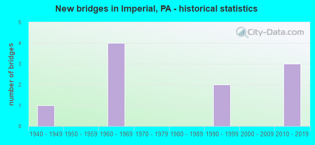
- New bridges - historical statistics
- 11940-1949
- 41960-1969
- 21990-1999
- 32010-2019


- Bridge Condition - Deck
- 33.3%Very good
- 66.7%Good

- Bridge Condition - Superstructure
- 66.7%Very good
- 33.3%Good

- Bridge Condition - Substructure
- 33.3%Very good
- 33.3%Good
- 33.3%Satisfactory
Find on map >> Show street view
Structure Number: 189, Location: RT.22 & 980 INTER. (Lat: 40.426228, Lng: -80.294147), Route carried "on" structure: State highway , Year Built: 1945, Year Reconstructed: 2013, Status: Open, Structure Length: 4.97m (16.31ft), Average Daily Traffic: 2,611 (year 2022), Truck Traffic: 9%, Average Future Daily Traffic: 4,227 (year 2032), Design Load: HL 93, Features Intersected: ABANDONED MOUNTOUR RR, Facility Carried by Structure: STEUBENVILLE PK
Minimum Vertical Clearance: 30+ m (98+ ft), Kilometerpoint: 0.000, Lanes on structure: 2, Owner: State Highway Agency, Approaching Roadway Width: 9.8m (32.2ft), Material/Design: Steel continuous, Design/Construction: Stringer/Multi-beam, Number Of Spans In Main Unit: 3, Length of Maximum Span: 16.2m (53.1ft), Curb or Sidewalk Widths: Left: 0.9m (3.0ft), Right: 0.3m (1.0ft), Curb-To-Curb Width: 7.9m (25.9ft), Out-to-Out Width: 10.1m (33.1ft)
Condition: Deck: Very good, Superstructure: Very good, Substructure: Very good, Operating Rating: 81.6 metric tons, Method Used To Determine Operating Rating: Assigned ratings based on Load and Resistance Factor Design (LRFD) reported by rating factor (RF) using HL93 loadings, Inventory Rating: 59.9 metric tons, Method Used To Determine Inventory Rating: Assigned ratings based on Load and Resistance Factor Design (LRFD) reported by rating factor (RF) using HL93 loadings, Structural Evaluation: Equal to present desirable criteria, Deck Geometry: High priority of corrective action, Approach Roadway Alignment: Equal to present desirable criteria, Length Of Structure Improvement: 4.90m (16.08ft), Designated Inspection Frequency: Every 48 months, Inspection Date: October 2020, Bridge Improvement Cost: $73,000, Roadway Improvement Cost: $216,000, Total Project Cost: $990,000, Deck Structure Type: Concrete Cast-file-Place, Wearing Surface/Protective System: Wearing Surface: Low Slump Concrete, Deck Protection: Epoxy Coated Reinforcing
Find on map >> Show street view
Structure Number: 2286, Location: MX04 2 MI E OF CLINTON RD (Lat: 40.483183, Lng: -80.266431), Route carried "on" structure: County highway , Year Built: 1960, Status: Open, Structure Length: 0.79m (2.59ft), Average Daily Traffic: 500 (year 2005), Truck Traffic: 5%, Average Future Daily Traffic: 500 (year 2025), Features Intersected: MONTOUR RUN NORTH BRANCH, Facility Carried by Structure: CLINTON-ENLOW RD
Minimum Vertical Clearance: 30+ m (98+ ft), Kilometerpoint: 0.000, Lanes on structure: 2, Owner: County Highway Agency, Approaching Roadway Width: 7.3m (24.0ft), Skew: 3 degrees, Material/Design: Concrete, Design/Construction: Slab, Number Of Spans In Main Unit: 1, Length of Maximum Span: 7.6m (24.9ft), Curb or Sidewalk Widths: Left: 0.4m (1.3ft), Right: 0.4m (1.3ft), Curb-To-Curb Width: 9.2m (30.2ft), Out-to-Out Width: 10.8m (35.4ft)
Condition: Deck: Good, Superstructure: Good, Substructure: Satisfactory, Channel: Fair, Operating Rating: 51.7 metric tons, Method Used To Determine Operating Rating: Field evaluation and documented engineering judgment, Inventory Rating: 30.8 metric tons, Method Used To Determine Inventory Rating: Field evaluation and documented engineering judgment, Structural Evaluation: Equal to present minimum criteria, Deck Geometry: Equal to present minimum criteria, Waterway Adequacy: Better than present minimum criteria, Approach Roadway Alignment: Equal to present desirable criteria, Length Of Structure Improvement: 0.80m (2.62ft), Designated Inspection Frequency: Every 24 months, Inspection Date: October 2021, Bridge Improvement Cost: $5,000, Roadway Improvement Cost: $37,000, Total Project Cost: $70,000, Wearing Surface/Protective System: Wearing Surface: Bituminous
Find on map >> Show street view
Structure Number: 46653, Location: SR 3051 OVER SR 22 (Lat: 40.430464, Lng: -80.264042), Route carried "on" structure: State highway , Year Built: 2011, Status: Open, Structure Length: 3.99m (13.09ft), Average Daily Traffic: 817 (year 2020), Truck Traffic: 16%, Average Future Daily Traffic: 1,777 (year 2032), Design Load: HL 93, Features Intersected: SR 22 EB WB, Facility Carried by Structure: KELSO ROAD
Minimum Vertical Clearance: 30+ m (98+ ft), Kilometerpoint: 0.014, Lanes on structure: 2, Lanes under structure: 4, Owner: State Highway Agency, Approaching Roadway Width: 12.2m (40.0ft), Material/Design: Prestressed concrete, Design/Construction: Box Beam or Girders - Single/Spread, Number Of Spans In Main Unit: 2, Length of Maximum Span: 19.5m (64.0ft), Curb or Sidewalk Widths: Left: 0.2m (0.7ft), Right: 0.2m (0.7ft), Curb-To-Curb Width: 12.2m (40.0ft), Out-to-Out Width: 13.2m (43.3ft)
Condition: Deck: Good, Superstructure: Very good, Substructure: Good, Operating Rating: 64.2 metric tons, Method Used To Determine Operating Rating: Assigned ratings based on Load and Resistance Factor Design (LRFD) reported by rating factor (RF) using HL93 loadings, Inventory Rating: 39.5 metric tons, Method Used To Determine Inventory Rating: Assigned ratings based on Load and Resistance Factor Design (LRFD) reported by rating factor (RF) using HL93 loadings, Structural Evaluation: Better than present minimum criteria, Deck Geometry: Equal to present desirable criteria, Underclear: Somewhat better than minimum adequacy, Approach Roadway Alignment: Better than present minimum criteria, Designated Inspection Frequency: Every 24 months, Inspection Date: May 2021, Deck Structure Type: Concrete Cast-file-Place, Wearing Surface/Protective System: Wearing Surface: Monolithic Concrete, Deck Protection: Epoxy Coated Reinforcing
Find on map >> Show street view
Structure Number: 547, Location: 761'E.OF WASH.CO.LINE (Lat: 40.426886, Lng: -80.294628), Route carried "under" structure: State highway , Year Built: 1964, Structure Length: 0. m, Average Daily Traffic: 2,132 (year 2021), Truck Traffic: 32%, Features Intersected: POTATO GARDEN RD., Facility Carried by Structure: SR 0022 SH
Minimum Vertical Clearance: 4.37m (14.34ft), Kilometerpoint: 0.000, Lanes on structure: 4, Lanes under structure: 2, Material/Design: Prestressed concrete, Design/Construction: Box Beam or Girders - Single/Spread, Length of Maximum Span: 19.8m (65.0ft)
Find on map >> Show street view
Structure Number: 548, Location: 150'N.OF SR3053 (Lat: 40.427172, Lng: -80.284875), Route carried "under" structure: City street 22, Year Built: 1963, Structure Length: 0. m, Average Daily Traffic: 8,216 (year 2005), Truck Traffic: 5%, Features Intersected: OLD STEUBENVILLE PIKE
Minimum Vertical Clearance: 4.47m (14.67ft), Kilometerpoint: 0.000, Lanes on structure: 4, Lanes under structure: 2, Material/Design: Prestressed concrete continuous, Design/Construction: Stringer/Multi-beam, Length of Maximum Span: 24.1m (79.1ft)
Find on map >> Show street view
Structure Number: 549, Location: OVER T 873 (Lat: 40.434494, Lng: -80.252383), Route carried "under" structure: City street , Year Built: 1964, Structure Length: 0. m, Average Daily Traffic: 1,951 (year 2003), Truck Traffic: 3%, Features Intersected: TWP RD 873 PARTRIDGE LN, Facility Carried by Structure: RT 0022 EB WB
Minimum Vertical Clearance: 4.57m (14.99ft), Kilometerpoint: 0.000, Lanes on structure: 4, Lanes under structure: 2, Material/Design: Prestressed concrete, Design/Construction: Box Beam or Girders - Single/Spread, Length of Maximum Span: 10.7m (35.1ft)
Find on map >> Show street view
Structure Number: 786, Location: NEAR MCCLAREN RN RD INTCH (Lat: 40.467917, Lng: -80.241094), Route carried "under" structure: ServiceOther road , Year Built: 1992, Structure Length: 0. m, Average Daily Traffic: 1 (year 2005), Truck Traffic: 1%, Features Intersected: SERVICE RD & MCCLAREN RN, Facility Carried by Structure: AIRPORT RD
Minimum Vertical Clearance: 7.54m (24.74ft), Kilometerpoint: 0.000, Lanes on structure: 3, Lanes under structure: 2, Material/Design: Steel continuous, Design/Construction: Stringer/Multi-beam, Length of Maximum Span: 65.2m (213.9ft)
Find on map >> Show street view
Structure Number: 787, Location: NEAR MCCLAREN RN RD INTCH (Lat: 40.467617, Lng: -80.240853), Route carried "under" structure: ServiceOther road , Year Built: 1992, Structure Length: 0. m, Average Daily Traffic: 1 (year 2005), Truck Traffic: 1%, Features Intersected: SERVICE RD & MCCLAREN RN, Facility Carried by Structure: AIRPORT EX
Minimum Vertical Clearance: 8.08m (26.51ft), Kilometerpoint: 0.000, Lanes on structure: 2, Lanes under structure: 2, Material/Design: Steel continuous, Design/Construction: Stringer/Multi-beam, Length of Maximum Span: 64.0m (210.0ft)
Find on map >> Show street view
Structure Number: 46653, Location: SR 3051 OVER SR 22 (Lat: 40.430464, Lng: -80.264042), Route carried "under" structure: US 22, Year Built: 2011, Structure Length: 0. m, Average Daily Traffic: 11,472 (year 2022), Truck Traffic: 17%, Features Intersected: SR 22 EB WB, Facility Carried by Structure: KELSO ROAD
Minimum Vertical Clearance: 5.49m (18.01ft), Kilometerpoint: 2.863, Lanes on structure: 2, Lanes under structure: 2, Material/Design: Prestressed concrete, Design/Construction: Box Beam or Girders - Single/Spread, Length of Maximum Span: 19.5m (64.0ft)
Find on map >> Show street view
Structure Number: 46653, Location: SR 3051 OVER SR 22 (Lat: 40.430464, Lng: -80.264042), Route carried "under" structure: US 22, Year Built: 2011, Structure Length: 0. m, Average Daily Traffic: 15,925 (year 2022), Truck Traffic: 12%, Features Intersected: SR 22 EB WB, Facility Carried by Structure: KELSO ROAD
Minimum Vertical Clearance: 5.49m (18.01ft), Kilometerpoint: 2.858, Lanes on structure: 2, Lanes under structure: 2, Material/Design: Prestressed concrete, Design/Construction: Box Beam or Girders - Single/Spread, Length of Maximum Span: 19.5m (64.0ft)