Bridge Statistics for Imlay City, Michigan (MI)
Condition, Traffic, Stress, Structural Evaluation, Project Costs
- National Bridge Inventory (NBI) Statistics
- 26Number of bridges
- 203ft / 62.1mTotal length
- $358,000Total costs
- 195,019Total average daily traffic
- 35,694Total average daily truck traffic
- National Bridge Inventory (NBI) Registered Bridges for Imlay City
- No street view available for this location
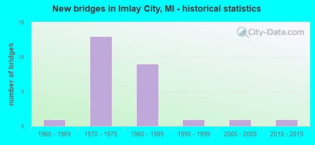
- New bridges - historical statistics
- 11960-1969
- 131970-1979
- 91980-1989
- 11990-1999
- 12000-2009
- 12010-2019


- Bridge Condition - Deck
- 6.7%Very good
- 26.7%Good
- 53.3%Satisfactory
- 13.3%Fair

- Bridge Condition - Superstructure
- 26.7%Very good
- 33.3%Good
- 33.3%Satisfactory
- 6.7%Fair

- Bridge Condition - Substructure
- 6.7%Very good
- 46.7%Good
- 40.0%Satisfactory
- 6.7%Fair

- Bridge Condition - Channel
- 11.1%Very good
- 33.3%Good
- 44.4%Satisfactory
- 11.1%Fair

- Bridge Condition - Culverts
- 33.3%Good
- 33.3%Satisfactory
- 33.3%Fair
Find on map >> Show street view
Structure Number: 5314, Location: 2.6 MI S OF IMLAY CITY (Lat: 42.988064, Lng: -83.067947), Route carried "on" structure: State highway 53, Year Built: 1963, Year Reconstructed: 2013, Status: Open, Structure Length: 1.52m (4.99ft), Average Daily Traffic: 19,650 (year 2013), Truck Traffic: 8%, Average Future Daily Traffic: 22,840 (year 2033), Design Load: HS 20, Features Intersected: WESTON DRAIN
Minimum Vertical Clearance: 30.48m (100.00ft), Kilometerpoint: 11.477, Lanes on structure: 2, Base Highway Network: Yes (Inventory Route: 75, Subroute: 9), Owner: State Highway Agency, Approaching Roadway Width: 15.8m (51.8ft), Skew: 4 degrees, Material/Design: Prestressed concrete, Design/Construction: Stringer/Multi-beam, Number Of Spans In Main Unit: 1, Length of Maximum Span: 14.1m (46.3ft), Curb-To-Curb Width: 15.8m (51.8ft), Out-to-Out Width: 16.8m (55.1ft)
Condition: Deck: Satisfactory, Superstructure: Good, Substructure: Satisfactory, Channel: Satisfactory, Operating Rating: 53.5 metric tons, Method Used To Determine Operating Rating: Load Factor (LF) rating reported by rating factor (RF) method using MS18 loading, Inventory Rating: 32.1 metric tons, Method Used To Determine Inventory Rating: Load Factor (LF) rating reported by rating factor (RF) method using MS18 loading, Structural Evaluation: Equal to present minimum criteria, Deck Geometry: Superior to present desirable criteria, Waterway Adequacy: Equal to present desirable criteria, Approach Roadway Alignment: Equal to present minimum criteria, Designated Inspection Frequency: Every 24 months, Inspection Date: April 2021, Deck Structure Type: Concrete Cast-file-Place, Wearing Surface/Protective System: Wearing Surface: Latex Concrete
Find on map >> Show street view
Structure Number: 5318, Location: 3.8 MI NORTH OF IMLAY CTY (Lat: 43.085978, Lng: -83.074972), Route carried "on" structure: State highway 53, Year Built: 1979, Status: Open, Structure Length: 0.79m (2.59ft), Average Daily Traffic: 10,276 (year 2007), Truck Traffic: 12%, Average Future Daily Traffic: 13,996 (year 2018), Design Load: HS 25 or greater, Features Intersected: ELK LAKE CREEK
Minimum Vertical Clearance: 30.48m (100.00ft), Kilometerpoint: 22.499, Lanes on structure: 2, Base Highway Network: Yes (Inventory Route: 75, Subroute: 9), Owner: State Highway Agency, Approaching Roadway Width: 13.7m (44.9ft), Material/Design: Prestressed concrete, Design/Construction: Box Beam or Girders - Multiple, Number Of Spans In Main Unit: 1, Length of Maximum Span: 7.9m (25.9ft), Curb-To-Curb Width: 14.0m (45.9ft), Out-to-Out Width: 14.8m (48.6ft)
Condition: Deck: Fair, Superstructure: Fair, Substructure: Fair, Channel: Fair, Operating Rating: 94.0 metric tons, Method Used To Determine Operating Rating: Load Factor (LF) rating reported by rating factor (RF) method using MS18 loading, Inventory Rating: 56.4 metric tons, Method Used To Determine Inventory Rating: Load Factor (LF) rating reported by rating factor (RF) method using MS18 loading, Structural Evaluation: Somewhat better than minimum adequacy, Deck Geometry: Superior to present desirable criteria, Waterway Adequacy: Equal to present desirable criteria, Approach Roadway Alignment: Equal to present desirable criteria, Designated Inspection Frequency: Every 24 months, Inspection Date: April 2021, Bridge Improvement Cost: $29,000, Roadway Improvement Cost: $2,000, Total Project Cost: $26,000, Deck Structure Type: Concrete Cast-file-Place, Wearing Surface/Protective System: Wearing Surface: Bituminous
Find on map >> Show street view
Structure Number: 5338, Location: 0.5 MI E OF M-53 (Lat: 43.001847, Lng: -83.059747), Route carried "on" structure: Interstate 69, Year Built: 1979, Status: Open, Structure Length: 1.10m (3.61ft), Average Daily Traffic: 13,836 (year 2007), Truck Traffic: 24%, Average Future Daily Traffic: 18,034 (year 2018), Design Load: HS 20+Mod, Features Intersected: N BRANCH BELL RIVER
Minimum Vertical Clearance: 30.48m (100.00ft), Kilometerpoint: 33.933, Lanes on structure: 4, Base Highway Network: Yes (Inventory Route: 75, Subroute: 2), Owner: State Highway Agency, Approaching Roadway Width: 14.6m (47.9ft), Material/Design: Concrete, Design/Construction: Culvert, Number Of Spans In Main Unit: 2, Length of Maximum Span: 5.1m (16.7ft), Out-to-Out Width: 32.3m (106.0ft)
Condition: Channel: Good, Culverts: Fair, Operating Rating: 97.2 metric tons, Method Used To Determine Operating Rating: Load Factor (LF) rating reported by rating factor (RF) method using MS18 loading, Inventory Rating: 73.5 metric tons, Method Used To Determine Inventory Rating: Load Factor (LF) rating reported by rating factor (RF) method using MS18 loading, Structural Evaluation: Somewhat better than minimum adequacy, Waterway Adequacy: Equal to present minimum criteria, Approach Roadway Alignment: Equal to present minimum criteria, Designated Inspection Frequency: Every 24 months, Inspection Date: May 2021, Wearing Surface/Protective System: Deck Protection: Epoxy Coated Reinforcing
Find on map >> Show street view
Structure Number: 5342, Location: 2 MI SW IMLAY CITY (Lat: 42.997364, Lng: -83.103242), Route carried "on" structure: Interstate 69, Year Built: 1983, Status: Open, Structure Length: 5.27m (17.29ft), Average Daily Traffic: 8,789 (year 2013), Truck Traffic: 20%, Average Future Daily Traffic: 10,107 (year 2033), Design Load: HS 25 or greater, Features Intersected: GTW RR (ABN)
Minimum Vertical Clearance: 30.48m (100.00ft), Kilometerpoint: 30.397, Lanes on structure: 2, Base Highway Network: Yes (Inventory Route: 75, Subroute: 2), Owner: State Highway Agency, Approaching Roadway Width: 14.6m (47.9ft), Skew: 3 degrees, Material/Design: Steel continuous, Design/Construction: Stringer/Multi-beam, Number Of Spans In Main Unit: 3, Length of Maximum Span: 20.7m (67.9ft), Curb-To-Curb Width: 13.4m (44.0ft), Out-to-Out Width: 14.6m (47.9ft)
Condition: Deck: Satisfactory, Superstructure: Satisfactory, Substructure: Satisfactory, Operating Rating: 97.2 metric tons, Method Used To Determine Operating Rating: Load Factor (LF) rating reported by rating factor (RF) method using MS18 loading, Inventory Rating: 59.3 metric tons, Method Used To Determine Inventory Rating: Load Factor (LF) rating reported by rating factor (RF) method using MS18 loading, Structural Evaluation: Equal to present minimum criteria, Deck Geometry: Superior to present desirable criteria, Approach Roadway Alignment: Equal to present desirable criteria, Designated Inspection Frequency: Every 24 months, Inspection Date: April 2021, Deck Structure Type: Concrete Cast-file-Place, Wearing Surface/Protective System: Wearing Surface: Epoxy Overlay, Deck Protection: Epoxy Coated Reinforcing
Find on map >> Show street view
Structure Number: 5343, Location: 2.0 M SW OF IMLAY CITY (Lat: 42.997711, Lng: -83.102983), Route carried "on" structure: Interstate 69, Year Built: 1983, Status: Open, Structure Length: 5.27m (17.29ft), Average Daily Traffic: 8,789 (year 2013), Truck Traffic: 20%, Average Future Daily Traffic: 10,107 (year 2033), Design Load: HS 25 or greater, Features Intersected: GTW RR (ABN)
Minimum Vertical Clearance: 30.48m (100.00ft), Kilometerpoint: 30.374, Lanes on structure: 2, Base Highway Network: Yes (Inventory Route: 75, Subroute: 10), Owner: State Highway Agency, Approaching Roadway Width: 14.6m (47.9ft), Skew: 3 degrees, Material/Design: Steel continuous, Design/Construction: Stringer/Multi-beam, Number Of Spans In Main Unit: 3, Length of Maximum Span: 20.7m (67.9ft), Curb-To-Curb Width: 13.4m (44.0ft), Out-to-Out Width: 14.6m (47.9ft)
Condition: Deck: Satisfactory, Superstructure: Satisfactory, Substructure: Good, Operating Rating: 97.2 metric tons, Method Used To Determine Operating Rating: Load Factor (LF) rating reported by rating factor (RF) method using MS18 loading, Inventory Rating: 59.3 metric tons, Method Used To Determine Inventory Rating: Load Factor (LF) rating reported by rating factor (RF) method using MS18 loading, Structural Evaluation: Equal to present minimum criteria, Deck Geometry: Superior to present desirable criteria, Approach Roadway Alignment: Equal to present desirable criteria, Designated Inspection Frequency: Every 24 months, Inspection Date: April 2021, Deck Structure Type: Concrete Cast-file-Place, Wearing Surface/Protective System: Wearing Surface: Epoxy Overlay, Deck Protection: Epoxy Coated Reinforcing
Find on map >> Show street view
Structure Number: 5354, Location: 2.0 M SW OF IMLAY CITY (Lat: 42.997269, Lng: -83.105336), Route carried "on" structure: Interstate 69, Year Built: 1983, Status: Open, Structure Length: 2.84m (9.32ft), Average Daily Traffic: 17,578 (year 2013), Truck Traffic: 20%, Average Future Daily Traffic: 20,215 (year 2033), Design Load: HS 25 or greater, Features Intersected: SUMMERS RD
Minimum Vertical Clearance: 30.48m (100.00ft), Kilometerpoint: 30.225, Lanes on structure: 2, Lanes under structure: 2, Base Highway Network: Yes (Inventory Route: 75, Subroute: 2), Owner: State Highway Agency, Approaching Roadway Width: 14.6m (47.9ft), Material/Design: Steel, Design/Construction: Stringer/Multi-beam, Number Of Spans In Main Unit: 1, Length of Maximum Span: 27.4m (89.9ft), Curb-To-Curb Width: 13.4m (44.0ft), Out-to-Out Width: 14.6m (47.9ft)
Condition: Deck: Satisfactory, Superstructure: Satisfactory, Substructure: Satisfactory, Operating Rating: 85.9 metric tons, Method Used To Determine Operating Rating: Load Factor (LF) rating reported by rating factor (RF) method using MS18 loading, Inventory Rating: 51.5 metric tons, Method Used To Determine Inventory Rating: Load Factor (LF) rating reported by rating factor (RF) method using MS18 loading, Structural Evaluation: Equal to present minimum criteria, Deck Geometry: Superior to present desirable criteria, Underclear: Somewhat better than minimum adequacy, Approach Roadway Alignment: Equal to present desirable criteria, Designated Inspection Frequency: Every 24 months, Inspection Date: April 2021, Deck Structure Type: Concrete Cast-file-Place, Wearing Surface/Protective System: Wearing Surface: Epoxy Overlay, Deck Protection: Epoxy Coated Reinforcing
Find on map >> Show street view
Structure Number: 5356, Location: 1.7 MI S OF IMLAY CITY (Lat: 42.999006, Lng: -83.085858), Route carried "on" structure: County highway 44, Year Built: 1983, Status: Open, Structure Length: 8.20m (26.90ft), Average Daily Traffic: 445 (year 1996), Truck Traffic: 2%, Average Future Daily Traffic: 1,500 (year 1977), Design Load: H 20, Features Intersected: I-69, Facility Carried by Structure: BLACKS CORNERS RD
Minimum Vertical Clearance: 30.48m (100.00ft), Kilometerpoint: 3.608, Lanes on structure: 2, Lanes under structure: 4, Owner: State Highway Agency, Approaching Roadway Width: 11.2m (36.7ft), Material/Design: Steel continuous, Design/Construction: Stringer/Multi-beam, Number Of Spans In Main Unit: 2, Length of Maximum Span: 40.3m (132.2ft), Curb-To-Curb Width: 11.1m (36.4ft), Out-to-Out Width: 12.2m (40.0ft)
Condition: Deck: Fair, Superstructure: Very good, Substructure: Good, Operating Rating: 67.4 metric tons, Method Used To Determine Operating Rating: Load Factor (LF) rating reported by rating factor (RF) method using MS18 loading, Inventory Rating: 40.5 metric tons, Method Used To Determine Inventory Rating: Load Factor (LF) rating reported by rating factor (RF) method using MS18 loading, Structural Evaluation: Better than present minimum criteria, Deck Geometry: Better than present minimum criteria, Underclear: Equal to present minimum criteria, Approach Roadway Alignment: Equal to present desirable criteria, Designated Inspection Frequency: Every 24 months, Inspection Date: December 2020, Deck Structure Type: Concrete Cast-file-Place, Wearing Surface/Protective System: Wearing Surface: Epoxy Overlay, Deck Protection: Epoxy Coated Reinforcing
Find on map >> Show street view
Structure Number: 5357, Location: 1.7 M S OF IMLAY CITY (Lat: 43.000597, Lng: -83.071128), Route carried "on" structure: State highway 53, Year Built: 1979, Status: Open, Structure Length: 7.98m (26.18ft), Average Daily Traffic: 15,625 (year 2012), Truck Traffic: 9%, Average Future Daily Traffic: 15,875 (year 2014), Design Load: HS 25 or greater, Features Intersected: I-69
Minimum Vertical Clearance: 30.48m (100.00ft), Kilometerpoint: 12.919, Lanes on structure: 5, Lanes under structure: 6, Base Highway Network: Yes (Inventory Route: 75, Subroute: 9), Owner: State Highway Agency, Approaching Roadway Width: 33.8m (110.9ft), Material/Design: Steel continuous, Design/Construction: Stringer/Multi-beam, Number Of Spans In Main Unit: 2, Length of Maximum Span: 39.2m (128.6ft), Curb-To-Curb Width: 31.9m (104.7ft), Out-to-Out Width: 33.1m (108.6ft)
Condition: Deck: Good, Superstructure: Satisfactory, Substructure: Satisfactory, Operating Rating: 79.7 metric tons, Method Used To Determine Operating Rating: Load Factor (LF) rating reported by rating factor (RF) method using MS18 loading, Inventory Rating: 48.0 metric tons, Method Used To Determine Inventory Rating: Load Factor (LF) rating reported by rating factor (RF) method using MS18 loading, Structural Evaluation: Equal to present minimum criteria, Deck Geometry: Superior to present desirable criteria, Underclear: Somewhat better than minimum adequacy, Approach Roadway Alignment: Equal to present desirable criteria, Designated Inspection Frequency: Every 24 months, Inspection Date: Febuary 2022, Deck Structure Type: Concrete Cast-file-Place, Wearing Surface/Protective System: Wearing Surface: Epoxy Overlay, Deck Protection: Epoxy Coated Reinforcing
Find on map >> Show street view
Structure Number: 5358, Location: 2.2 MI SE OF IMLAY CITY (Lat: 43.001078, Lng: -83.046564), Route carried "on" structure: County highway , Year Built: 1979, Status: Open, Structure Length: 8.17m (26.80ft), Average Daily Traffic: 520 (year 1995), Truck Traffic: 2%, Average Future Daily Traffic: 500 (year 1977), Design Load: H 20, Features Intersected: I-69, Facility Carried by Structure: BOWMAN ROAD
Minimum Vertical Clearance: 30.48m (100.00ft), Kilometerpoint: 8.409, Lanes on structure: 2, Lanes under structure: 4, Owner: State Highway Agency, Approaching Roadway Width: 12.2m (40.0ft), Material/Design: Steel continuous, Design/Construction: Stringer/Multi-beam, Number Of Spans In Main Unit: 2, Length of Maximum Span: 40.8m (133.9ft), Curb-To-Curb Width: 11.4m (37.4ft), Out-to-Out Width: 12.1m (39.7ft)
Condition: Deck: Satisfactory, Superstructure: Very good, Substructure: Good, Operating Rating: 66.1 metric tons, Method Used To Determine Operating Rating: Load Factor (LF) rating reported by rating factor (RF) method using MS18 loading, Inventory Rating: 39.5 metric tons, Method Used To Determine Inventory Rating: Load Factor (LF) rating reported by rating factor (RF) method using MS18 loading, Structural Evaluation: Better than present minimum criteria, Deck Geometry: Better than present minimum criteria, Underclear: Meets minimum limits, Approach Roadway Alignment: Equal to present desirable criteria, Length Of Structure Improvement: 8.17m (26.80ft), Designated Inspection Frequency: Every 24 months, Inspection Date: January 2022, Bridge Improvement Cost: $200,000, Roadway Improvement Cost: $10,000, Total Project Cost: $121,000, Deck Structure Type: Concrete Cast-file-Place, Wearing Surface/Protective System: Wearing Surface: Epoxy Overlay, Deck Protection: Epoxy Coated Reinforcing
Find on map >> Show street view
Structure Number: 5359, Location: 3.0 MI SE OF IMLAY CITY (Lat: 42.999933, Lng: -83.026792), Route carried "on" structure: County highway , Year Built: 1978, Status: Open, Structure Length: 8.53m (27.99ft), Average Daily Traffic: 95 (year 1994), Truck Traffic: 2%, Average Future Daily Traffic: 500 (year 1977), Design Load: H 20, Features Intersected: I-69, Facility Carried by Structure: BRISTOL ROAD
Minimum Vertical Clearance: 30.48m (100.00ft), Kilometerpoint: 1.366, Lanes on structure: 2, Lanes under structure: 4, Owner: State Highway Agency, Approaching Roadway Width: 10.3m (33.8ft), Skew: 1 degrees, Material/Design: Steel continuous, Design/Construction: Stringer/Multi-beam, Number Of Spans In Main Unit: 2, Length of Maximum Span: 42.9m (140.7ft), Curb-To-Curb Width: 11.3m (37.1ft), Out-to-Out Width: 12.1m (39.7ft)
Condition: Deck: Satisfactory, Superstructure: Good, Substructure: Good, Operating Rating: 74.5 metric tons, Method Used To Determine Operating Rating: Load Factor (LF) rating reported by rating factor (RF) method using MS18 loading, Inventory Rating: 44.7 metric tons, Method Used To Determine Inventory Rating: Load Factor (LF) rating reported by rating factor (RF) method using MS18 loading, Structural Evaluation: Better than present minimum criteria, Deck Geometry: Superior to present desirable criteria, Underclear: Somewhat better than minimum adequacy, Approach Roadway Alignment: Equal to present desirable criteria, Length Of Structure Improvement: 8.54m (28.02ft), Designated Inspection Frequency: Every 24 months, Inspection Date: January 2022, Bridge Improvement Cost: $215,000, Roadway Improvement Cost: $11,000, Total Project Cost: $129,000, Deck Structure Type: Concrete Cast-file-Place, Wearing Surface/Protective System: Wearing Surface: Epoxy Overlay
Find on map >> Show street view
Structure Number: 536, Location: 4.2 MI SE OF IMLAY CITY (Lat: 42.994956, Lng: -83.006897), Route carried "on" structure: Interstate 69, Year Built: 1979, Status: Open, Structure Length: 2.89m (9.48ft), Average Daily Traffic: 6,918 (year 2007), Truck Traffic: 24%, Average Future Daily Traffic: 9,017 (year 2018), Design Load: HS 25 or greater, Features Intersected: GRAHAM ROAD
Minimum Vertical Clearance: 30.48m (100.00ft), Kilometerpoint: 38.397, Lanes on structure: 2, Lanes under structure: 2, Base Highway Network: Yes (Inventory Route: 75, Subroute: 2), Owner: State Highway Agency, Approaching Roadway Width: 13.7m (44.9ft), Skew: 1 degrees, Material/Design: Steel, Design/Construction: Stringer/Multi-beam, Number Of Spans In Main Unit: 1, Length of Maximum Span: 28.9m (94.8ft), Curb-To-Curb Width: 12.9m (42.3ft), Out-to-Out Width: 14.0m (45.9ft)
Condition: Deck: Satisfactory, Superstructure: Very good, Substructure: Satisfactory, Inventory Rating: 74.2 metric tons, Method Used To Determine Inventory Rating: Load Factor (LF), Structural Evaluation: Equal to present minimum criteria, Deck Geometry: Superior to present desirable criteria, Underclear: Somewhat better than minimum adequacy, Approach Roadway Alignment: Equal to present desirable criteria, Length Of Structure Improvement: 2.90m (9.51ft), Designated Inspection Frequency: Every 24 months, Inspection Date: January 2022, Bridge Improvement Cost: $64,000, Roadway Improvement Cost: $4,000, Total Project Cost: $41,000, Deck Structure Type: Concrete Cast-file-Place, Wearing Surface/Protective System: Wearing Surface: Epoxy Overlay, Deck Protection: Epoxy Coated Reinforcing
Find on map >> Show street view
Structure Number: 5361, Location: 4.2 MI SE OF IMLAY CITY (Lat: 42.995289, Lng: -83.006900), Route carried "on" structure: Interstate 69, Year Built: 1979, Status: Open, Structure Length: 2.89m (9.48ft), Average Daily Traffic: 6,918 (year 2007), Truck Traffic: 24%, Average Future Daily Traffic: 9,017 (year 2018), Design Load: HS 25 or greater, Features Intersected: GRAHAM ROAD
Minimum Vertical Clearance: 30.48m (100.00ft), Kilometerpoint: 38.354, Lanes on structure: 2, Lanes under structure: 2, Base Highway Network: Yes (Inventory Route: 75, Subroute: 10), Owner: State Highway Agency, Approaching Roadway Width: 13.1m (43.0ft), Material/Design: Steel, Design/Construction: Stringer/Multi-beam, Number Of Spans In Main Unit: 1, Length of Maximum Span: 28.9m (94.8ft), Curb-To-Curb Width: 13.4m (44.0ft), Out-to-Out Width: 14.0m (45.9ft)
Condition: Deck: Satisfactory, Superstructure: Good, Substructure: Good, Operating Rating: 92.7 metric tons, Method Used To Determine Operating Rating: Load Factor (LF) rating reported by rating factor (RF) method using MS18 loading, Inventory Rating: 55.4 metric tons, Method Used To Determine Inventory Rating: Load Factor (LF) rating reported by rating factor (RF) method using MS18 loading, Structural Evaluation: Better than present minimum criteria, Deck Geometry: Superior to present desirable criteria, Underclear: Somewhat better than minimum adequacy, Approach Roadway Alignment: Equal to present desirable criteria, Length Of Structure Improvement: 2.90m (9.51ft), Designated Inspection Frequency: Every 24 months, Inspection Date: January 2022, Bridge Improvement Cost: $64,000, Roadway Improvement Cost: $4,000, Total Project Cost: $41,000, Deck Structure Type: Concrete Cast-file-Place, Wearing Surface/Protective System: Wearing Surface: Epoxy Overlay, Deck Protection: Epoxy Coated Reinforcing
Find on map >> Show street view
Structure Number: 5391, Location: SEC. 16 IMLAY TWP. (Lat: 43.030150, Lng: -83.067125), Route carried "on" structure: County highway 4434, Year Built: 2017, Status: Open, Structure Length: 1.52m (4.99ft), Average Daily Traffic: 6,854 (year 2016), Truck Traffic: 17%, Average Future Daily Traffic: 9,231 (year 2036), Design Load: Greater than HL93, Features Intersected: BELLE RIVER DRAIN, Facility Carried by Structure: IMLAY CITY ROAD
Minimum Vertical Clearance: 30+ m (98+ ft), Kilometerpoint: 34.267, Lanes on structure: 2, Owner: County Highway Agency, Approaching Roadway Width: 12.2m (40.0ft), Material/Design: Prestressed concrete, Design/Construction: Box Beam or Girders - Single/Spread, Number Of Spans In Main Unit: 1, Length of Maximum Span: 14.8m (48.6ft), Curb-To-Curb Width: 12.2m (40.0ft), Out-to-Out Width: 12.9m (42.3ft)
Condition: Deck: Very good, Superstructure: Very good, Substructure: Very good, Channel: Very good, Operating Rating: 62.9 metric tons, Method Used To Determine Operating Rating: Load and Resistance Factor Rating (LRFR) rating reported by rating factor(RF) method using HL-93 loadings, Inventory Rating: 48.6 metric tons, Method Used To Determine Inventory Rating: Load and Resistance Factor Rating (LRFR) rating reported by rating factor(RF) method using HL-93 loadings, Structural Evaluation: Equal to present desirable criteria, Deck Geometry: Somewhat better than minimum adequacy, Waterway Adequacy: Equal to present desirable criteria, Approach Roadway Alignment: Better than present minimum criteria, Designated Inspection Frequency: Every 24 months, Inspection Date: September 2021, Deck Structure Type: Concrete Cast-file-Place, Wearing Surface/Protective System: Wearing Surface: Monolithic Concrete, Deck Protection: Epoxy Coated Reinforcing
Find on map >> Show street view
Structure Number: 5395, Location: SEC. 6 ALMONT TWP. (Lat: 42.976900, Lng: -83.087500), Route carried "on" structure: ServiceCounty highway , Year Built: 1983, Status: Open, Structure Length: 1.09m (3.58ft), Average Daily Traffic: 270 (year 2018), Average Future Daily Traffic: 330 (year 2038), Design Load: HS 20, Features Intersected: WESTON DRAIN, Facility Carried by Structure: MUIR ROAD
Minimum Vertical Clearance: 30.48m (100.00ft), Kilometerpoint: 2.652, Lanes on structure: 2, Owner: County Highway Agency, Approaching Roadway Width: 7.9m (25.9ft), Material/Design: Wood or Timber, Design/Construction: Slab, Number Of Spans In Main Unit: 2, Length of Maximum Span: 5.1m (16.7ft), Curb-To-Curb Width: 7.9m (25.9ft), Out-to-Out Width: 8.3m (27.2ft)
Condition: Deck: Good, Superstructure: Good, Substructure: Good, Channel: Satisfactory, Operating Rating: 45.0 metric tons, Method Used To Determine Operating Rating: Allowable Stress (AS) rating reported by rating factor (RF) method using MS18 loading, Inventory Rating: 31.8 metric tons, Method Used To Determine Inventory Rating: Allowable Stress (AS) rating reported by rating factor (RF) method using MS18 loading, Structural Evaluation: Better than present minimum criteria, Deck Geometry: Somewhat better than minimum adequacy, Waterway Adequacy: Equal to present desirable criteria, Approach Roadway Alignment: Equal to present minimum criteria, Designated Inspection Frequency: Every 24 months, Inspection Date: June 2021, Deck Structure Type: Wood or Timber, Wearing Surface/Protective System: Wearing Surface: Bituminous, Deck Protection: Epoxy Coated Reinforcing
Find on map >> Show street view
Structure Number: 5422, Location: SEC. 21-28 GOODLAND TWP. (Lat: 43.094914, Lng: -83.067367), Route carried "on" structure: ServiceCounty highway , Year Built: 2003, Status: Open, Structure Length: 1.14m (3.74ft), Average Daily Traffic: 30 (year 2020), Truck Traffic: 2%, Average Future Daily Traffic: 37 (year 2040), Design Load: HS 20, Features Intersected: NORTH BR. MILL CREEK DN., Facility Carried by Structure: ARMSTRONG ROAD
Minimum Vertical Clearance: 30.48m (100.00ft), Kilometerpoint: 3.544, Lanes on structure: 2, Owner: County Highway Agency, Approaching Roadway Width: 7.6m (24.9ft), Material/Design: Prestressed concrete, Design/Construction: Box Beam or Girders - Multiple, Number Of Spans In Main Unit: 1, Length of Maximum Span: 9.2m (30.2ft), Curb-To-Curb Width: 7.6m (24.9ft), Out-to-Out Width: 8.5m (27.9ft)
Condition: Deck: Good, Superstructure: Good, Substructure: Good, Channel: Satisfactory, Operating Rating: 77.4 metric tons, Method Used To Determine Operating Rating: Load Factor (LF) rating reported by rating factor (RF) method using MS18 loading, Inventory Rating: 46.3 metric tons, Method Used To Determine Inventory Rating: Load Factor (LF) rating reported by rating factor (RF) method using MS18 loading, Structural Evaluation: Better than present minimum criteria, Deck Geometry: Equal to present minimum criteria, Waterway Adequacy: Equal to present minimum criteria, Approach Roadway Alignment: Equal to present desirable criteria, Designated Inspection Frequency: Every 24 months, Inspection Date: July 2021, Deck Structure Type: Concrete Precast Panels, Wearing Surface/Protective System: Wearing Surface: Bituminous, Membrane: Preformed Fabric
Find on map >> Show street view
Structure Number: 5426, Location: SEC. 21-28 IMLAY TWP. (Lat: 43.007617, Lng: -83.059864), Route carried "on" structure: ServiceCounty highway , Year Built: 1985, Status: Open, Structure Length: 0.79m (2.59ft), Average Daily Traffic: 1,120 (year 2018), Average Future Daily Traffic: 1,367 (year 2038), Design Load: HS 20, Features Intersected: BELLE RIVER DRAIN, Facility Carried by Structure: NEWARK ROAD
Minimum Vertical Clearance: 30.48m (100.00ft), Kilometerpoint: 21.321, Lanes on structure: 2, Owner: County Highway Agency, Approaching Roadway Width: 7.3m (24.0ft), Material/Design: Concrete, Design/Construction: Culvert, Number Of Spans In Main Unit: 1, Length of Maximum Span: 7.3m (24.0ft), Out-to-Out Width: 14.6m (47.9ft)
Condition: Channel: Good, Culverts: Good, Operating Rating: 32.7 metric tons, Method Used To Determine Operating Rating: Field evaluation and documented engineering judgment, Inventory Rating: 32.7 metric tons, Method Used To Determine Inventory Rating: Field evaluation and documented engineering judgment, Structural Evaluation: Better than present minimum criteria, Waterway Adequacy: Equal to present desirable criteria, Approach Roadway Alignment: Equal to present desirable criteria, Designated Inspection Frequency: Every 24 months, Inspection Date: July 2021
Find on map >> Show street view
Structure Number: 5427, Location: SEC. 31 IMLAY TWP. (Lat: 42.981456, Lng: -83.104319), Route carried "on" structure: County highway , Year Built: 1992, Status: Posted for load, Structure Length: 1.22m (4.00ft), Average Daily Traffic: 405 (year 2018), Average Future Daily Traffic: 494 (year 2038), Design Load: HS 20, Features Intersected: WESTON DRAIN, Facility Carried by Structure: SUMMERS ROAD
Minimum Vertical Clearance: 30.48m (100.00ft), Kilometerpoint: 0.594, Lanes on structure: 2, Owner: County Highway Agency, Approaching Roadway Width: 9.1m (29.9ft), Skew: 2 degrees, Material/Design: Prestressed concrete, Design/Construction: Tee Beam, Number Of Spans In Main Unit: 1, Length of Maximum Span: 11.2m (36.7ft), Curb-To-Curb Width: 9.4m (30.8ft), Out-to-Out Width: 10.1m (33.1ft)
Condition: Deck: Good, Superstructure: Satisfactory, Substructure: Satisfactory, Channel: Good, Operating Rating: 42.4 metric tons, Method Used To Determine Operating Rating: Load Factor (LF) rating reported by rating factor (RF) method using MS18 loading, Inventory Rating: 25.6 metric tons, Method Used To Determine Inventory Rating: Load Factor (LF) rating reported by rating factor (RF) method using MS18 loading, Structural Evaluation: Equal to present minimum criteria, Deck Geometry: Equal to present minimum criteria, Waterway Adequacy: Superior to present desirable criteria, Approach Roadway Alignment: Equal to present desirable criteria, Bridge Posting: Required (Relationship of Operating Rating to Maximum Legal Load: 10.0 - 19.9% below), Designated Inspection Frequency: Every 24 months, Inspection Date: July 2021, Deck Structure Type: Concrete Precast Panels, Wearing Surface/Protective System: Wearing Surface: Bituminous, Deck Protection: Epoxy Coated Reinforcing
Find on map >> Show street view
Structure Number: 5428, Location: SEC. 31 IMLAY TWP. (Lat: 42.977100, Lng: -83.094233), Route carried "on" structure: ServiceCounty highway , Year Built: 1972, Status: Open, Structure Length: 0.88m (2.89ft), Average Daily Traffic: 95 (year 2018), Average Future Daily Traffic: 116 (year 2038), Design Load: H 20, Features Intersected: WESTON DRAIN, Facility Carried by Structure: BLACKS CORNERS RD.
Minimum Vertical Clearance: 30.48m (100.00ft), Kilometerpoint: 0.460, Lanes on structure: 2, Owner: County Highway Agency, Approaching Roadway Width: 6.1m (20.0ft), Skew: 3 degrees, Material/Design: Steel, Design/Construction: Culvert, Number Of Spans In Main Unit: 2, Length of Maximum Span: 3.6m (11.8ft), Out-to-Out Width: 16.8m (55.1ft)
Condition: Channel: Satisfactory, Culverts: Satisfactory, Operating Rating: 97.2 metric tons, Method Used To Determine Operating Rating: Load Factor (LF) rating reported by rating factor (RF) method using MS18 loading, Inventory Rating: 70.0 metric tons, Method Used To Determine Inventory Rating: Load Factor (LF) rating reported by rating factor (RF) method using MS18 loading, Structural Evaluation: Equal to present minimum criteria, Waterway Adequacy: Equal to present desirable criteria, Approach Roadway Alignment: Equal to present minimum criteria, Designated Inspection Frequency: Every 24 months, Inspection Date: July 2021
Find on map >> Show street view
Structure Number: 5354, Location: 2.0 M SW OF IMLAY CITY (Lat: 42.997269, Lng: -83.105336), Route carried "under" structure: County highway 44, Year Built: 1983, Structure Length: 0. m, Average Daily Traffic: 360 (year 1997), Truck Traffic: 2%, Features Intersected: SUMMERS RD, Facility Carried by Structure: I-69 EB
Minimum Vertical Clearance: 4.78m (15.68ft), Kilometerpoint: 2.351, Lanes on structure: 2, Lanes under structure: 2, Material/Design: Steel, Design/Construction: Stringer/Multi-beam, Length of Maximum Span: 27.4m (89.9ft)
Find on map >> Show street view
Structure Number: 5355, Location: 2.0 M SW OF IMLAY CITY (Lat: 42.997597, Lng: -83.105358), Route carried "under" structure: County highway 44, Year Built: 1983, Structure Length: 0. m, Average Daily Traffic: 360 (year 1997), Truck Traffic: 2%, Features Intersected: SUMMERS RD, Facility Carried by Structure: I-69 WB
Minimum Vertical Clearance: 4.57m (14.99ft), Kilometerpoint: 2.388, Lanes on structure: 2, Lanes under structure: 2, Material/Design: Steel, Design/Construction: Stringer/Multi-beam, Length of Maximum Span: 27.4m (89.9ft)
Find on map >> Show street view
Structure Number: 5356, Location: 1.7 MI S OF IMLAY CITY (Lat: 42.999006, Lng: -83.085858), Route carried "under" structure: Interstate 69, Year Built: 1983, Structure Length: 0. m, Average Daily Traffic: 22,482 (year 2007), Truck Traffic: 20%, Features Intersected: I-69, Facility Carried by Structure: BLACKS CORNERS RD
Minimum Vertical Clearance: 5.46m (17.91ft), Kilometerpoint: 31.826, Lanes on structure: 2, Lanes under structure: 4, Material/Design: Steel continuous, Design/Construction: Stringer/Multi-beam, Length of Maximum Span: 40.3m (132.2ft)
Find on map >> Show street view
Structure Number: 5357, Location: 1.7 M S OF IMLAY CITY (Lat: 43.000597, Lng: -83.071128), Route carried "under" structure: Interstate 69, Year Built: 1979, Structure Length: 0. m, Average Daily Traffic: 22,482 (year 2007), Truck Traffic: 24%, Features Intersected: I-69, Facility Carried by Structure: M-53
Minimum Vertical Clearance: 5.51m (18.08ft), Kilometerpoint: 33.039, Lanes on structure: 5, Lanes under structure: 6, Material/Design: Steel continuous, Design/Construction: Stringer/Multi-beam, Length of Maximum Span: 39.2m (128.6ft)
Find on map >> Show street view
Structure Number: 5358, Location: 2.2 MI SE OF IMLAY CITY (Lat: 43.001078, Lng: -83.046564), Route carried "under" structure: Interstate 69, Year Built: 1979, Structure Length: 0. m, Average Daily Traffic: 13,836 (year 2007), Truck Traffic: 24%, Features Intersected: I-69, Facility Carried by Structure: BOWMAN ROAD
Minimum Vertical Clearance: 5.03m (16.50ft), Kilometerpoint: 35.051, Lanes on structure: 2, Lanes under structure: 4, Material/Design: Steel continuous, Design/Construction: Stringer/Multi-beam, Length of Maximum Span: 40.8m (133.9ft)
Find on map >> Show street view
Structure Number: 5359, Location: 3.0 MI SE OF IMLAY CITY (Lat: 42.999933, Lng: -83.026792), Route carried "under" structure: Interstate 69, Year Built: 1978, Structure Length: 0. m, Average Daily Traffic: 13,836 (year 2007), Truck Traffic: 24%, Features Intersected: I-69, Facility Carried by Structure: BRISTOL ROAD
Minimum Vertical Clearance: 5.18m (16.99ft), Kilometerpoint: 36.670, Lanes on structure: 2, Lanes under structure: 4, Material/Design: Steel continuous, Design/Construction: Stringer/Multi-beam, Length of Maximum Span: 42.9m (140.7ft)
Find on map >> Show street view
Structure Number: 536, Location: 4.2 MI SE OF IMLAY CITY (Lat: 42.994956, Lng: -83.006897), Route carried "under" structure: County highway , Year Built: 1979, Structure Length: 0. m, Average Daily Traffic: 1,725 (year 1995), Truck Traffic: 3%, Features Intersected: GRAHAM ROAD, Facility Carried by Structure: I-69 EB
Minimum Vertical Clearance: 4.70m (15.42ft), Kilometerpoint: 1.545, Lanes on structure: 2, Lanes under structure: 2, Material/Design: Steel, Design/Construction: Stringer/Multi-beam, Length of Maximum Span: 28.9m (94.8ft)
Find on map >> Show street view
Structure Number: 5361, Location: 4.2 MI SE OF IMLAY CITY (Lat: 42.995289, Lng: -83.006900), Route carried "under" structure: County highway , Year Built: 1979, Structure Length: 0. m, Average Daily Traffic: 1,725 (year 1995), Truck Traffic: 2%, Features Intersected: GRAHAM ROAD, Facility Carried by Structure: I-69 WB
Minimum Vertical Clearance: 4.47m (14.67ft), Kilometerpoint: 1.582, Lanes on structure: 2, Lanes under structure: 2, Material/Design: Steel, Design/Construction: Stringer/Multi-beam, Length of Maximum Span: 28.9m (94.8ft)