Bridge Statistics for Ida, Louisiana (LA)
Condition, Traffic, Stress, Structural Evaluation, Project Costs
- National Bridge Inventory (NBI) Statistics
- 21Number of bridges
- 312ft / 94.7mTotal length
- 121,323Total average daily traffic
- 18,729Total average daily truck traffic
- National Bridge Inventory (NBI) Registered Bridges for Ida
- No street view available for this location
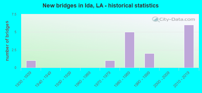
- New bridges - historical statistics
- 11930-1939
- 11970-1979
- 51980-1989
- 21990-1999
- 62010-2019


- Bridge Condition - Deck
- 33.3%Very good
- 41.7%Good
- 16.7%Satisfactory
- 8.3%Fair

- Bridge Condition - Superstructure
- 33.3%Very good
- 41.7%Good
- 16.7%Satisfactory
- 8.3%Fair

- Bridge Condition - Substructure
- 33.3%Very good
- 25.0%Good
- 8.3%Satisfactory
- 16.7%Fair
- 16.7%Poor

- Bridge Condition - Channel
- 18.2%Very good
- 63.6%Good
- 18.2%Satisfactory

- Bridge Condition - Culverts
- 66.7%Good
- 33.3%Satisfactory
Find on map >> Show street view
Structure Number: 40900000040276, Location: 0.8 MI. W. OF US 71 (Lat: 33.007500, Lng: -93.904719), Route carried "on" structure: County highway , Year Built: 2010, Status: Open, Structure Length: 12.19m (39.99ft), Average Daily Traffic: 10,300 (year 2016), Truck Traffic: 19%, Average Future Daily Traffic: 110 (year 2037), Design Load: HS 20, Features Intersected: I-49, Facility Carried by Structure: IDA STATELINE RD
Minimum Vertical Clearance: 30+ m (98+ ft), Kilometerpoint: 0.380, Lanes on structure: 2, Lanes under structure: 4, Owner: State Highway Agency, Approaching Roadway Width: 6.4m (21.0ft), Skew: 7 degrees, Material/Design: Prestressed concrete continuous, Design/Construction: Stringer/Multi-beam, Number Of Spans In Main Unit: 4, Length of Maximum Span: 30.5m (100.1ft), Curb or Sidewalk Widths: Left: 1.7m (5.6ft), Right: 1.7m (5.6ft), Curb-To-Curb Width: 9.6m (31.5ft), Out-to-Out Width: 10.4m (34.1ft)
Condition: Deck: Very good, Superstructure: Very good, Substructure: Very good, Operating Rating: 63.2 metric tons, Method Used To Determine Operating Rating: Load and Resistance Factor Rating (LRFR) rating reported by rating factor(RF) method using HL-93 loadings, Inventory Rating: 33.4 metric tons, Method Used To Determine Inventory Rating: Load and Resistance Factor Rating (LRFR) rating reported by rating factor(RF) method using HL-93 loadings, Structural Evaluation: Equal to present desirable criteria, Deck Geometry: Meets minimum limits, Underclear: Meets minimum limits, Approach Roadway Alignment: Equal to present minimum criteria, Designated Inspection Frequency: Every 24 months, Inspection Date: March 2020, Deck Structure Type: Concrete Cast-file-Place
Find on map >> Show street view
Structure Number: 40900000040288, Location: 1.3 MILES WEST OF JCT OF (Lat: 32.977569, Lng: -93.910289), Route carried "on" structure: County highway , Year Built: 2011, Status: Open, Structure Length: 18.90m (62.01ft), Average Daily Traffic: 10,262 (year 2016), Truck Traffic: 36%, Average Future Daily Traffic: 162 (year 2037), Design Load: HS 20, Features Intersected: I-49 UNDER MUNNERLYN CHA, Facility Carried by Structure: MUNNERLYN CHAPEL
Minimum Vertical Clearance: 30+ m (98+ ft), Kilometerpoint: 1.180, Lanes on structure: 2, Lanes under structure: 4, Base Highway Network: Yes (Inventory Route: 455-09-1, Subroute: 10), Owner: State Highway Agency, Approaching Roadway Width: 6.4m (21.0ft), Skew: 34 degrees, Material/Design: Steel continuous, Design/Construction: Girder and Floorbeam System, Number Of Spans In Main Unit: 4, Length of Maximum Span: 47.2m (154.9ft), Curb-To-Curb Width: 9.1m (29.9ft), Out-to-Out Width: 10.0m (32.8ft)
Condition: Deck: Very good, Superstructure: Very good, Substructure: Very good, Operating Rating: 42.1 metric tons, Method Used To Determine Operating Rating: Load and Resistance Factor Rating (LRFR) rating reported by rating factor(RF) method using HL-93 loadings, Inventory Rating: 32.4 metric tons, Method Used To Determine Inventory Rating: Load and Resistance Factor Rating (LRFR) rating reported by rating factor(RF) method using HL-93 loadings, Structural Evaluation: Equal to present desirable criteria, Deck Geometry: Meets minimum limits, Underclear: Meets minimum limits, Approach Roadway Alignment: Better than present minimum criteria, Designated Inspection Frequency: Every 24 months, Inspection Date: January 2021, Deck Structure Type: Concrete Cast-file-Place, Wearing Surface/Protective System: Wearing Surface: Monolithic Concrete
Find on map >> Show street view
Structure Number: 40900000040387, Location: I-49 OVER MYRA-MYRTIS RD (Lat: 32.942450, Lng: -93.897500), Route carried "on" structure: Interstate 49, Year Built: 2014, Status: Open, Structure Length: 17.37m (56.99ft), Average Daily Traffic: 5,131 (year 2016), Truck Traffic: 36%, Average Future Daily Traffic: 10,944 (year 2036), Design Load: HL 93, Features Intersected: MYRA-MIRTUS RD
Minimum Vertical Clearance: 30+ m (98+ ft), Kilometerpoint: 49.246, Lanes on structure: 2, Lanes under structure: 2, Base Highway Network: Yes (Inventory Route: 455-09-1, Subroute: 10), Owner: State Highway Agency, Approaching Roadway Width: 12.2m (40.0ft), Skew: 32 degrees, Material/Design: Prestressed concrete, Design/Construction: Stringer/Multi-beam, Number Of Spans In Main Unit: 1, Number Of Approach Spans: 5, Length of Maximum Span: 37.8m (124.0ft), Curb-To-Curb Width: 12.2m (40.0ft), Out-to-Out Width: 13.0m (42.7ft)
Condition: Deck: Very good, Superstructure: Very good, Substructure: Very good, Operating Rating: 45.0 metric tons, Method Used To Determine Operating Rating: Load and Resistance Factor Rating (LRFR) rating reported by rating factor(RF) method using HL-93 loadings, Inventory Rating: 24.6 metric tons, Method Used To Determine Inventory Rating: Load and Resistance Factor Rating (LRFR) rating reported by rating factor(RF) method using HL-93 loadings, Structural Evaluation: Equal to present minimum criteria, Deck Geometry: Better than present minimum criteria, Approach Roadway Alignment: Equal to present desirable criteria, Designated Inspection Frequency: Every 24 months, Inspection Date: May 2020, Deck Structure Type: Concrete Cast-file-Place, Wearing Surface/Protective System: Wearing Surface: Monolithic Concrete
Find on map >> Show street view
Structure Number: 40900000040388, Location: I-49 OVER MYRA-MYRTIS RD (Lat: 32.943950, Lng: -93.898089), Route carried "on" structure: Interstate 49, Year Built: 2014, Status: Open, Structure Length: 18.62m (61.09ft), Average Daily Traffic: 5,131 (year 2016), Truck Traffic: 36%, Average Future Daily Traffic: 9,764 (year 2036), Design Load: HL 93, Features Intersected: MYRA-MYRTIS RD
Minimum Vertical Clearance: 30+ m (98+ ft), Kilometerpoint: 8.692, Lanes on structure: 2, Lanes under structure: 2, Base Highway Network: Yes (Inventory Route: 455-09-2, Subroute: 10), Owner: State Highway Agency, Approaching Roadway Width: 12.2m (40.0ft), Skew: 32 degrees, Material/Design: Prestressed concrete, Design/Construction: Stringer/Multi-beam, Number Of Spans In Main Unit: 2, Number Of Approach Spans: 4, Length of Maximum Span: 37.8m (124.0ft), Curb-To-Curb Width: 12.1m (39.7ft), Out-to-Out Width: 13.0m (42.7ft)
Condition: Deck: Very good, Superstructure: Very good, Substructure: Very good, Operating Rating: 45.0 metric tons, Method Used To Determine Operating Rating: Load and Resistance Factor Rating (LRFR) rating reported by rating factor(RF) method using HL-93 loadings, Inventory Rating: 24.6 metric tons, Method Used To Determine Inventory Rating: Load and Resistance Factor Rating (LRFR) rating reported by rating factor(RF) method using HL-93 loadings, Structural Evaluation: Equal to present minimum criteria, Deck Geometry: Equal to present minimum criteria, Approach Roadway Alignment: Equal to present desirable criteria, Designated Inspection Frequency: Every 24 months, Inspection Date: May 2020, Deck Structure Type: Concrete Cast-file-Place, Wearing Surface/Protective System: Wearing Surface: Monolithic Concrete
Find on map >> Show street view
Structure Number: 4090000004039, Location: 0.92 MI S. OF LA 168 (Lat: 32.984269, Lng: -93.910600), Route carried "on" structure: Interstate 49, Year Built: 2014, Status: Open, Structure Length: 0.67m (2.20ft), Average Daily Traffic: 10,262 (year 2016), Truck Traffic: 36%, Average Future Daily Traffic: 9,764 (year 2036), Design Load: HL 93, Features Intersected: HARTMAN BRANCH
Minimum Vertical Clearance: 30+ m (98+ ft), Kilometerpoint: 54.058, Lanes on structure: 4, Base Highway Network: Yes (Inventory Route: 455-09-1, Subroute: 10), Owner: State Highway Agency, Approaching Roadway Width: 24.1m (79.1ft), Skew: 30 degrees, Material/Design: Concrete, Design/Construction: Culvert, Number Of Spans In Main Unit: 2, Length of Maximum Span: 3.0m (9.8ft)
Condition: Channel: Very good, Culverts: Good, Operating Rating: 97.2 metric tons, Method Used To Determine Operating Rating: Load and Resistance Factor Rating (LRFR) rating reported by rating factor(RF) method using HL-93 loadings, Inventory Rating: 74.5 metric tons, Method Used To Determine Inventory Rating: Load and Resistance Factor Rating (LRFR) rating reported by rating factor(RF) method using HL-93 loadings, Structural Evaluation: Better than present minimum criteria, Waterway Adequacy: Equal to present desirable criteria, Approach Roadway Alignment: Equal to present desirable criteria, Designated Inspection Frequency: Every 24 months, Inspection Date: May 2020, Deck Structure Type: Other
Find on map >> Show street view
Structure Number: 409000000404, Location: 0.34 MI. N. OF LA 168 (Lat: 33.002150, Lng: -93.907400), Route carried "on" structure: Interstate 49, Year Built: 2013, Status: Open, Structure Length: 0.67m (2.20ft), Average Daily Traffic: 10,262 (year 2016), Truck Traffic: 36%, Average Future Daily Traffic: 7,552 (year 2036), Design Load: HL 93, Features Intersected: NANCE BRANCH
Minimum Vertical Clearance: 30+ m (98+ ft), Kilometerpoint: 56.074, Lanes on structure: 4, Base Highway Network: Yes (Inventory Route: 455-09-1, Subroute: 10), Owner: State Highway Agency, Approaching Roadway Width: 23.2m (76.1ft), Skew: 30 degrees, Material/Design: Concrete, Design/Construction: Culvert, Number Of Spans In Main Unit: 2, Length of Maximum Span: 3.0m (9.8ft)
Condition: Channel: Very good, Culverts: Good, Operating Rating: 42.1 metric tons, Method Used To Determine Operating Rating: Load and Resistance Factor Rating (LRFR) rating reported by rating factor(RF) method using HL-93 loadings, Inventory Rating: 32.4 metric tons, Method Used To Determine Inventory Rating: Load and Resistance Factor Rating (LRFR) rating reported by rating factor(RF) method using HL-93 loadings, Structural Evaluation: Better than present minimum criteria, Waterway Adequacy: Equal to present desirable criteria, Approach Roadway Alignment: Equal to present desirable criteria, Designated Inspection Frequency: Every 24 months, Inspection Date: July 2020, Deck Structure Type: Concrete Precast Panels
Find on map >> Show street view
Structure Number: 40900110411051, Location: 6.6 MI NORTH OF LA 2 (Lat: 32.976200, Lng: -93.894000), Route carried "on" structure: US 71, Year Built: 1981, Status: Open, Structure Length: 3.66m (12.01ft), Average Daily Traffic: 3,700 (year 2016), Truck Traffic: 26%, Average Future Daily Traffic: 4,366 (year 2036), Design Load: HS 20, Features Intersected: FLAG BRANCH
Minimum Vertical Clearance: 30+ m (98+ ft), Kilometerpoint: 17.832, Lanes on structure: 2, Base Highway Network: Yes (Inventory Route: 11-04-1, Subroute: 10), Owner: State Highway Agency, Approaching Roadway Width: 12.5m (41.0ft), Material/Design: Concrete, Design/Construction: Slab, Number Of Spans In Main Unit: 6, Length of Maximum Span: 6.1m (20.0ft), Curb-To-Curb Width: 12.2m (40.0ft), Out-to-Out Width: 13.0m (42.7ft)
Condition: Deck: Satisfactory, Superstructure: Satisfactory, Substructure: Good, Channel: Good, Operating Rating: 68.0 metric tons, Method Used To Determine Operating Rating: Load Factor (LF), Inventory Rating: 40.8 metric tons, Method Used To Determine Inventory Rating: Load Factor (LF), Structural Evaluation: Equal to present minimum criteria, Deck Geometry: Equal to present minimum criteria, Waterway Adequacy: Better than present minimum criteria, Approach Roadway Alignment: Equal to present desirable criteria, Designated Inspection Frequency: Every 24 months, Inspection Date: January 2022, Deck Structure Type: Concrete Cast-file-Place
Find on map >> Show street view
Structure Number: 40900110412251, Location: 7.8 MI NORTH OF LA 2 (Lat: 32.993689, Lng: -93.895400), Route carried "on" structure: US 71, Year Built: 1935, Year Reconstructed: 1999, Status: Open, Structure Length: 0.70m (2.30ft), Average Daily Traffic: 3,700 (year 2016), Truck Traffic: 26%, Average Future Daily Traffic: 4,366 (year 2036), Design Load: H 15, Features Intersected: DRAIN
Minimum Vertical Clearance: 30+ m (98+ ft), Kilometerpoint: 19.772, Lanes on structure: 2, Base Highway Network: Yes (Inventory Route: 11-04-1, Subroute: 10), Owner: State Highway Agency, Approaching Roadway Width: 11.6m (38.1ft), Material/Design: Concrete, Design/Construction: Culvert, Number Of Spans In Main Unit: 2, Length of Maximum Span: 3.0m (9.8ft), Curb-To-Curb Width: 12.3m (40.4ft), Out-to-Out Width: 17.7m (58.1ft)
Condition: Channel: Good, Culverts: Satisfactory, Operating Rating: 42.1 metric tons, Method Used To Determine Operating Rating: Load and Resistance Factor Rating (LRFR) rating reported by rating factor(RF) method using HL-93 loadings, Inventory Rating: 32.4 metric tons, Method Used To Determine Inventory Rating: Load and Resistance Factor Rating (LRFR) rating reported by rating factor(RF) method using HL-93 loadings, Structural Evaluation: Equal to present minimum criteria, Deck Geometry: Equal to present minimum criteria, Waterway Adequacy: Better than present minimum criteria, Approach Roadway Alignment: Equal to present desirable criteria, Designated Inspection Frequency: Every 24 months, Inspection Date: January 2022, Deck Structure Type: Concrete Cast-file-Place
Find on map >> Show street view
Structure Number: 40900950206381, Location: 6.38 MI E OF LA 1 (Lat: 33.000281, Lng: -93.904200), Route carried "on" structure: State highway 168, Year Built: 1983, Status: Open, Structure Length: 2.90m (9.51ft), Average Daily Traffic: 380 (year 2016), Truck Traffic: 19%, Average Future Daily Traffic: 708 (year 2036), Design Load: HS 20, Features Intersected: NANCE BRANCH
Minimum Vertical Clearance: 30+ m (98+ ft), Kilometerpoint: 10.268, Lanes on structure: 2, Owner: State Highway Agency, Approaching Roadway Width: 11.0m (36.1ft), Material/Design: Concrete, Design/Construction: Slab, Number Of Spans In Main Unit: 5, Length of Maximum Span: 5.8m (19.0ft), Curb-To-Curb Width: 9.8m (32.2ft), Out-to-Out Width: 10.7m (35.1ft)
Condition: Deck: Fair, Superstructure: Fair, Substructure: Poor, Channel: Good, Operating Rating: 37.3 metric tons, Method Used To Determine Operating Rating: Load and Resistance Factor Rating (LRFR) rating reported by rating factor(RF) method using HL-93 loadings, Inventory Rating: 28.8 metric tons, Method Used To Determine Inventory Rating: Load and Resistance Factor Rating (LRFR) rating reported by rating factor(RF) method using HL-93 loadings, Structural Evaluation: Meets minimum limits, Deck Geometry: Better than present minimum criteria, Waterway Adequacy: Equal to present minimum criteria, Approach Roadway Alignment: Equal to present minimum criteria, Designated Inspection Frequency: Every 24 months, Underwater Inspection Frequency: Every 60 months, Other Special Inspection Frequency: Every 12 months, Inspection Date: January 2021, Underwater Inspection Date: November 2020, Other Special Inspection Date: January 2022, Deck Structure Type: Concrete Precast Panels, Wearing Surface/Protective System: Wearing Surface: Bituminous
Find on map >> Show street view
Structure Number: 40932567935221, Location: 1.0 M EAST OF US 71 (Lat: 32.945719, Lng: -93.870000), Route carried "on" structure: County highway , Year Built: 1989, Status: Open, Structure Length: 4.57m (14.99ft), Average Daily Traffic: 150 (year 2019), Average Future Daily Traffic: 236 (year 2036), Design Load: HS 20, Features Intersected: KELLY BAYOU, Facility Carried by Structure: Mira Scotts Slu
Minimum Vertical Clearance: 30+ m (98+ ft), Kilometerpoint: 0.000, Lanes on structure: 2, Owner: County Highway Agency, Approaching Roadway Width: 9.1m (29.9ft), Skew: 3 degrees, Material/Design: Prestressed concrete, Design/Construction: Stringer/Multi-beam, Number Of Spans In Main Unit: 3, Length of Maximum Span: 15.2m (49.9ft), Curb-To-Curb Width: 8.6m (28.2ft), Out-to-Out Width: 9.4m (30.8ft)
Condition: Deck: Good, Superstructure: Good, Substructure: Good, Channel: Good, Operating Rating: 49.2 metric tons, Method Used To Determine Operating Rating: Load and Resistance Factor Rating (LRFR) rating reported by rating factor(RF) method using HL-93 loadings, Inventory Rating: 29.2 metric tons, Method Used To Determine Inventory Rating: Load and Resistance Factor Rating (LRFR) rating reported by rating factor(RF) method using HL-93 loadings, Structural Evaluation: Better than present minimum criteria, Deck Geometry: Equal to present minimum criteria, Waterway Adequacy: Equal to present desirable criteria, Approach Roadway Alignment: Equal to present desirable criteria, Designated Inspection Frequency: Every 24 months, Inspection Date: March 2021, Deck Structure Type: Concrete Cast-file-Place
Find on map >> Show street view
Structure Number: 40932583935131, Location: 1.6 MI S OF INT 531 (Lat: 32.972119, Lng: -93.855931), Route carried "on" structure: County highway , Year Built: 1980, Status: Posted for load, Structure Length: 1.80m (5.91ft), Average Daily Traffic: 59 (year 2019), Average Future Daily Traffic: 283 (year 2036), Design Load: HS 20, Features Intersected: TRIBUTARY TO KELLY BAYOU, Facility Carried by Structure: Gilliam Scotts Slu
Minimum Vertical Clearance: 30+ m (98+ ft), Kilometerpoint: 0.000, Lanes on structure: 2, Owner: County Highway Agency, Approaching Roadway Width: 9.1m (29.9ft), Material/Design: Concrete, Design/Construction: Slab, Number Of Spans In Main Unit: 3, Length of Maximum Span: 5.8m (19.0ft), Curb-To-Curb Width: 8.6m (28.2ft), Out-to-Out Width: 9.4m (30.8ft)
Condition: Deck: Satisfactory, Superstructure: Satisfactory, Substructure: Fair, Channel: Satisfactory, Operating Rating: 26.9 metric tons, Method Used To Determine Operating Rating: Load and Resistance Factor Rating (LRFR) rating reported by rating factor(RF) method using HL-93 loadings, Inventory Rating: 20.7 metric tons, Method Used To Determine Inventory Rating: Load and Resistance Factor Rating (LRFR) rating reported by rating factor(RF) method using HL-93 loadings, Structural Evaluation: Somewhat better than minimum adequacy, Deck Geometry: Better than present minimum criteria, Waterway Adequacy: Better than present minimum criteria, Approach Roadway Alignment: Equal to present desirable criteria, Designated Inspection Frequency: Every 24 months, Inspection Date: March 2021, Deck Structure Type: Concrete Precast Panels, Wearing Surface/Protective System: Wearing Surface: Bituminous
Find on map >> Show street view
Structure Number: 40932590935431, Location: 0.75M W OF US 71 (Lat: 32.984119, Lng: -93.905269), Route carried "on" structure: County highway , Year Built: 1993, Status: Open, Structure Length: 2.38m (7.81ft), Average Daily Traffic: 78 (year 2019), Average Future Daily Traffic: 162 (year 2036), Design Load: HS 20, Features Intersected: HARTMAN BRANCH, Facility Carried by Structure: MUNERLYN CHAPEL RD
Minimum Vertical Clearance: 30+ m (98+ ft), Kilometerpoint: 0.000, Lanes on structure: 2, Owner: County Highway Agency, Approaching Roadway Width: 10.7m (35.1ft), Material/Design: Concrete, Design/Construction: Slab, Number Of Spans In Main Unit: 4, Length of Maximum Span: 5.8m (19.0ft), Curb-To-Curb Width: 8.7m (28.5ft), Out-to-Out Width: 9.6m (31.5ft)
Condition: Deck: Good, Superstructure: Good, Substructure: Fair, Channel: Satisfactory, Operating Rating: 26.9 metric tons, Method Used To Determine Operating Rating: Load and Resistance Factor Rating (LRFR) rating reported by rating factor(RF) method using HL-93 loadings, Inventory Rating: 20.7 metric tons, Method Used To Determine Inventory Rating: Load and Resistance Factor Rating (LRFR) rating reported by rating factor(RF) method using HL-93 loadings, Structural Evaluation: Somewhat better than minimum adequacy, Deck Geometry: Better than present minimum criteria, Waterway Adequacy: Equal to present desirable criteria, Approach Roadway Alignment: Equal to present desirable criteria, Designated Inspection Frequency: Every 24 months, Inspection Date: March 2021, Deck Structure Type: Concrete Cast-file-Place
Find on map >> Show street view
Structure Number: 40933000935311, Location: 1 MI. E. US HWY 71 (Lat: 33.000419, Lng: -93.882400), Route carried "on" structure: County highway , Year Built: 1976, Status: Posted for load, Structure Length: 2.35m (7.71ft), Average Daily Traffic: 77 (year 2019), Average Future Daily Traffic: 542 (year 2036), Design Load: HS 20, Features Intersected: NANCE BRANCH, Facility Carried by Structure: Ida Missionary Rd
Minimum Vertical Clearance: 30+ m (98+ ft), Kilometerpoint: 0.000, Lanes on structure: 2, Owner: County Highway Agency, Approaching Roadway Width: 10.4m (34.1ft), Material/Design: Concrete, Design/Construction: Slab, Number Of Spans In Main Unit: 4, Length of Maximum Span: 5.8m (19.0ft), Curb-To-Curb Width: 8.6m (28.2ft), Out-to-Out Width: 9.5m (31.2ft)
Condition: Deck: Good, Superstructure: Good, Substructure: Poor, Channel: Good, Operating Rating: 20.1 metric tons, Method Used To Determine Operating Rating: Load and Resistance Factor Rating (LRFR) rating reported by rating factor(RF) method using HL-93 loadings, Inventory Rating: 15.6 metric tons, Method Used To Determine Inventory Rating: Load and Resistance Factor Rating (LRFR) rating reported by rating factor(RF) method using HL-93 loadings, Structural Evaluation: Meets minimum limits, Deck Geometry: Better than present minimum criteria, Waterway Adequacy: Better than present minimum criteria, Approach Roadway Alignment: Equal to present minimum criteria, Bridge Posting: Required (Relationship of Operating Rating to Maximum Legal Load: 30.0 - 39.9% below), Designated Inspection Frequency: Every 24 months, Underwater Inspection Frequency: Every 60 months, Other Special Inspection Frequency: Every 12 months, Inspection Date: March 2021, Underwater Inspection Date: July 2020, Deck Structure Type: Concrete Precast Panels, Wearing Surface/Protective System: Wearing Surface: Bituminous
Find on map >> Show street view
Structure Number: 40933001935211, Location: 1.8M EAST OF US 71 (Lat: 33.001989, Lng: -93.865189), Route carried "on" structure: County highway , Year Built: 1994, Status: Open, Structure Length: 6.10m (20.01ft), Average Daily Traffic: 200 (year 2019), Average Future Daily Traffic: 318 (year 2036), Design Load: HS 20, Features Intersected: KELLY BAYOU, Facility Carried by Structure: Ida Missionary Rd
Minimum Vertical Clearance: 30+ m (98+ ft), Kilometerpoint: 0.000, Lanes on structure: 2, Owner: County Highway Agency, Approaching Roadway Width: 7.9m (25.9ft), Material/Design: Prestressed concrete, Design/Construction: Stringer/Multi-beam, Number Of Spans In Main Unit: 4, Length of Maximum Span: 15.2m (49.9ft), Curb-To-Curb Width: 8.5m (27.9ft), Out-to-Out Width: 9.4m (30.8ft)
Condition: Deck: Good, Superstructure: Good, Substructure: Good, Channel: Good, Operating Rating: 45.7 metric tons, Method Used To Determine Operating Rating: Load and Resistance Factor Rating (LRFR) rating reported by rating factor(RF) method using HL-93 loadings, Inventory Rating: 23.3 metric tons, Method Used To Determine Inventory Rating: Load and Resistance Factor Rating (LRFR) rating reported by rating factor(RF) method using HL-93 loadings, Structural Evaluation: Equal to present minimum criteria, Deck Geometry: Equal to present minimum criteria, Waterway Adequacy: Equal to present desirable criteria, Approach Roadway Alignment: Equal to present desirable criteria, Designated Inspection Frequency: Every 24 months, Underwater Inspection Frequency: Every 60 months, Inspection Date: March 2021, Underwater Inspection Date: July 2020, Deck Structure Type: Concrete Cast-file-Place
Find on map >> Show street view
Structure Number: 40933003935171, Location: 2.0 MI EAST OF US 71 (Lat: 33.005311, Lng: -93.860800), Route carried "on" structure: County highway , Year Built: 1989, Status: Open, Structure Length: 1.80m (5.91ft), Average Daily Traffic: 59 (year 2019), Average Future Daily Traffic: 184 (year 2036), Design Load: HS 20, Features Intersected: BARDSTOWN BAYOU, Facility Carried by Structure: Wynn Rd
Minimum Vertical Clearance: 30+ m (98+ ft), Kilometerpoint: 0.000, Lanes on structure: 2, Owner: County Highway Agency, Approaching Roadway Width: 8.5m (27.9ft), Material/Design: Concrete, Design/Construction: Slab, Number Of Spans In Main Unit: 3, Length of Maximum Span: 5.8m (19.0ft), Curb-To-Curb Width: 8.6m (28.2ft), Out-to-Out Width: 9.4m (30.8ft)
Condition: Deck: Good, Superstructure: Good, Substructure: Satisfactory, Channel: Good, Operating Rating: 26.9 metric tons, Method Used To Determine Operating Rating: Load and Resistance Factor Rating (LRFR) rating reported by rating factor(RF) method using HL-93 loadings, Inventory Rating: 20.7 metric tons, Method Used To Determine Inventory Rating: Load and Resistance Factor Rating (LRFR) rating reported by rating factor(RF) method using HL-93 loadings, Structural Evaluation: Equal to present minimum criteria, Deck Geometry: Better than present minimum criteria, Waterway Adequacy: Better than present minimum criteria, Approach Roadway Alignment: Equal to present desirable criteria, Designated Inspection Frequency: Every 24 months, Underwater Inspection Frequency: Every 60 months, Inspection Date: March 2021, Underwater Inspection Date: July 2020, Deck Structure Type: Concrete Precast Panels
Find on map >> Show street view
Structure Number: 40900000040274, Location: 1.5 MI S OF STATE LINE (Lat: 32.997281, Lng: -93.909131), Route carried "under" structure: Interstate 20, Structure Length: 0. m, Average Daily Traffic: 10,262 (year 2015), Features Intersected: I-49 N UNDER LA 168, Facility Carried by Structure: I-49
Minimum Vertical Clearance: 6.40m (21.00ft), Kilometerpoint: 55.664, Lanes on structure: 2, Length of Maximum Span: 0.0m
Find on map >> Show street view
Structure Number: 40900000040274, Location: 1.5 MI S OF STATE LINE (Lat: 32.997461, Lng: -93.909450), Route carried "under" structure: Interstate 20, Structure Length: 0. m, Average Daily Traffic: 10,262 (year 2015), Features Intersected: I-49 S UNDER LA 168, Facility Carried by Structure: I-49
Minimum Vertical Clearance: 6.19m (20.31ft), Kilometerpoint: 2.572, Lanes on structure: 2, Length of Maximum Span: 0.0m
Find on map >> Show street view
Structure Number: 40900000040276, Location: 0.8 MI S OF STATE LINE (Lat: 33.008000, Lng: -93.905450), Route carried "under" structure: Interstate 49, Structure Length: 0. m, Average Daily Traffic: 10,262 (year 2015), Features Intersected: IDA STATE LINE RD OVER I
Minimum Vertical Clearance: 5.43m (17.81ft), Kilometerpoint: 1.345, Lanes on structure: 2, Length of Maximum Span: 0.0m
Find on map >> Show street view
Structure Number: 40900000040276, Location: 0.8 MI S OF STATE LINE (Lat: 33.007689, Lng: -93.905150), Route carried "under" structure: Interstate 49, Structure Length: 0. m, Average Daily Traffic: 10,262 (year 2015), Features Intersected: IDA STATE LINE RD OVER I
Minimum Vertical Clearance: 5.55m (18.21ft), Kilometerpoint: 56.692, Lanes on structure: 2, Length of Maximum Span: 0.0m
Find on map >> Show street view
Structure Number: 40900000040288, Location: 3.0 MI S OF STATE LINE (Lat: 32.978389, Lng: -93.909581), Route carried "under" structure: Interstate 49, Structure Length: 0. m, Average Daily Traffic: 10,262 (year 2015), Features Intersected: MUNNERLYN CHAPEL RD OVER
Minimum Vertical Clearance: 5.33m (17.49ft), Kilometerpoint: 1.292, Lanes on structure: 2, Length of Maximum Span: 0.0m
Find on map >> Show street view
Structure Number: 40900000040288, Location: 3.0 MI S OF STATE LINE (Lat: 32.978131, Lng: -93.909919), Route carried "under" structure: Interstate 49, Structure Length: 0. m, Average Daily Traffic: 10,262 (year 2015), Features Intersected: MUNNERLYN CHAPEL RD OVER
Minimum Vertical Clearance: 5.73m (18.80ft), Kilometerpoint: 1.250, Lanes on structure: 2, Length of Maximum Span: 0.0m