Bridge Statistics for Hyndman, Pennsylvania (PA)
Condition, Traffic, Stress, Structural Evaluation, Project Costs
- National Bridge Inventory (NBI) Statistics
- 10Number of bridges
- 102ft / 31.3mTotal length
- $5,290,000Total costs
- 7,647Total average daily traffic
- 1,108Total average daily truck traffic
- 8,638Total future (year 2032) average daily traffic
- National Bridge Inventory (NBI) Registered Bridges for Hyndman
- No street view available for this location
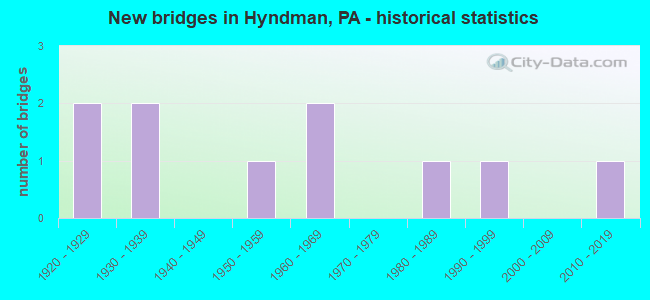
- New bridges - historical statistics
- 21920-1929
- 21930-1939
- 11950-1959
- 21960-1969
- 11980-1989
- 11990-1999
- 12010-2019

- Reconstructed bridges - Historical Statistics
- 11950-1959
- 01960-1969
- 01970-1979
- 21980-1989
- 21990-1999
- 32000-2009


- Bridge Condition - Deck
- 60.0%Good
- 20.0%Satisfactory
- 20.0%Fair

- Bridge Condition - Superstructure
- 10.0%Very good
- 20.0%Good
- 10.0%Satisfactory
- 60.0%Fair

- Bridge Condition - Substructure
- 20.0%Good
- 40.0%Satisfactory
- 40.0%Fair

- Bridge Condition - Channel
- 10.0%Very good
- 50.0%Satisfactory
- 10.0%Fair
- 30.0%Poor
Find on map >> Show street view
Structure Number: 4076, Location: 0.1 MILE NORTH OF SR 3003 (Lat: 39.758225, Lng: -78.696453), Route carried "on" structure: US 220, Year Built: 1926, Year Reconstructed: 1957, Status: Open, Structure Length: 0.76m (2.49ft), Average Daily Traffic: 4,524 (year 2022), Truck Traffic: 18%, Average Future Daily Traffic: 4,429 (year 2032), Design Load: H 15, Features Intersected: TR.EVITTS CREEK
Minimum Vertical Clearance: 30+ m (98+ ft), Kilometerpoint: 4.426, Lanes on structure: 2, Base Highway Network: Yes, Owner: State Highway Agency, Approaching Roadway Width: 11.0m (36.1ft), Material/Design: Concrete, Design/Construction: Tee Beam, Number Of Spans In Main Unit: 1, Length of Maximum Span: 7.3m (24.0ft), Curb-To-Curb Width: 11.4m (37.4ft), Out-to-Out Width: 12.6m (41.3ft)
Condition: Deck: Satisfactory, Superstructure: Fair, Substructure: Satisfactory, Channel: Poor, Operating Rating: 56.2 metric tons, Method Used To Determine Operating Rating: Load Factor (LF), Inventory Rating: 33.6 metric tons, Method Used To Determine Inventory Rating: Load Factor (LF), Structural Evaluation: Somewhat better than minimum adequacy, Deck Geometry: Somewhat better than minimum adequacy, Waterway Adequacy: Equal to present minimum criteria, Approach Roadway Alignment: Equal to present desirable criteria, Length Of Structure Improvement: 0.90m (2.95ft), Designated Inspection Frequency: Every 24 months, Inspection Date: April 2021, Bridge Improvement Cost: $39,000, Roadway Improvement Cost: $225,000, Total Project Cost: $523,000, Deck Structure Type: Concrete Cast-file-Place, Wearing Surface/Protective System: Wearing Surface: Bituminous, Membrane: Preformed Fabric
Find on map >> Show street view
Structure Number: 4287, Location: 2 MILE N.OF COOKS MILLS (Lat: 39.777592, Lng: -78.726536), Route carried "on" structure: State highway , Year Built: 1961, Year Reconstructed: 2008, Status: Open, Structure Length: 5.97m (19.59ft), Average Daily Traffic: 265 (year 2020), Truck Traffic: 9%, Average Future Daily Traffic: 382 (year 2040), Design Load: HS 20, Features Intersected: WILLS CREEK, Facility Carried by Structure: T654 CREEK ROAD
Minimum Vertical Clearance: 30+ m (98+ ft), Kilometerpoint: 0.045, Lanes on structure: 2, Owner: State Highway Agency, Approaching Roadway Width: 7.9m (25.9ft), Skew: 3 degrees, Material/Design: Prestressed concrete, Design/Construction: Box Beam or Girders - Multiple, Number Of Spans In Main Unit: 3, Length of Maximum Span: 19.5m (64.0ft), Curb-To-Curb Width: 8.5m (27.9ft), Out-to-Out Width: 10.2m (33.5ft)
Condition: Deck: Good, Superstructure: Fair, Substructure: Fair, Channel: Poor, Operating Rating: 86.2 metric tons, Method Used To Determine Operating Rating: Load Factor (LF), Inventory Rating: 20.0 metric tons, Method Used To Determine Inventory Rating: Load Factor (LF), Structural Evaluation: Somewhat better than minimum adequacy, Deck Geometry: Equal to present minimum criteria, Waterway Adequacy: Equal to present desirable criteria, Approach Roadway Alignment: Better than present minimum criteria, Length Of Structure Improvement: 7.40m (24.28ft), Designated Inspection Frequency: Every 24 months, Inspection Date: September 2021, Bridge Improvement Cost: $180,000, Roadway Improvement Cost: $531,000, Total Project Cost: $2,433,000, Deck Structure Type: Concrete Cast-file-Place, Wearing Surface/Protective System: Wearing Surface: Monolithic Concrete, Deck Protection: Epoxy Coated Reinforcing
Find on map >> Show street view
Structure Number: 4288, Location: 2 MI.S.OF HYNDMAN (Lat: 39.786758, Lng: -78.724008), Route carried "on" structure: State highway , Year Built: 1939, Year Reconstructed: 1988, Status: Open, Structure Length: 3.35m (10.99ft), Average Daily Traffic: 265 (year 2020), Truck Traffic: 9%, Average Future Daily Traffic: 382 (year 2032), Design Load: H 15, Features Intersected: WILLS CREEK, Facility Carried by Structure: T654 CREEK ROAD
Minimum Vertical Clearance: 30+ m (98+ ft), Kilometerpoint: 0.105, Lanes on structure: 1, Owner: State Highway Agency, Approaching Roadway Width: 7.0m (23.0ft), Skew: 1 degrees, Material/Design: Steel, Design/Construction: Stringer/Multi-beam, Number Of Spans In Main Unit: 2, Length of Maximum Span: 16.2m (53.1ft), Curb-To-Curb Width: 4.6m (15.1ft), Out-to-Out Width: 4.7m (15.4ft)
Condition: Deck: Fair, Superstructure: Fair, Substructure: Fair, Channel: Poor, Operating Rating: 74.4 metric tons, Method Used To Determine Operating Rating: Load Factor (LF), Inventory Rating: 44.5 metric tons, Method Used To Determine Inventory Rating: Load Factor (LF), Structural Evaluation: Somewhat better than minimum adequacy, Deck Geometry: High priority of replacement, Waterway Adequacy: Equal to present desirable criteria, Approach Roadway Alignment: Somewhat better than minimum adequacy, Length Of Structure Improvement: 4.20m (13.78ft), Designated Inspection Frequency: Every 24 months, Inspection Date: June 2020, Bridge Improvement Cost: $102,000, Roadway Improvement Cost: $300,000, Total Project Cost: $1,376,000, Deck Structure Type: Closed Grating, Wearing Surface/Protective System: Wearing Surface: Bituminous
Find on map >> Show street view
Structure Number: 429, Location: HYNDMAN (Lat: 39.808769, Lng: -78.722642), Route carried "on" structure: State highway , Year Built: 1954, Year Reconstructed: 1991, Status: Open, Structure Length: 0.73m (2.40ft), Average Daily Traffic: 265 (year 2020), Truck Traffic: 9%, Average Future Daily Traffic: 382 (year 2032), Design Load: H 20, Features Intersected: WILLS HILL RUN, Facility Carried by Structure: T654 CREEK ROAD
Minimum Vertical Clearance: 30+ m (98+ ft), Kilometerpoint: 0.143, Lanes on structure: 2, Owner: State Highway Agency, Approaching Roadway Width: 7.3m (24.0ft), Skew: 4 degrees, Material/Design: Prestressed concrete, Design/Construction: Slab, Number Of Spans In Main Unit: 1, Length of Maximum Span: 6.7m (22.0ft), Curb-To-Curb Width: 7.3m (24.0ft), Out-to-Out Width: 7.8m (25.6ft)
Condition: Deck: Good, Superstructure: Very good, Substructure: Good, Channel: Satisfactory, Operating Rating: 89.8 metric tons, Method Used To Determine Operating Rating: Load Factor (LF), Inventory Rating: 56.2 metric tons, Method Used To Determine Inventory Rating: Load Factor (LF), Structural Evaluation: Better than present minimum criteria, Deck Geometry: Somewhat better than minimum adequacy, Waterway Adequacy: Better than present minimum criteria, Approach Roadway Alignment: Better than present minimum criteria, Length Of Structure Improvement: 1.40m (4.59ft), Designated Inspection Frequency: Every 48 months, Inspection Date: May 2020, Deck Structure Type: Concrete Cast-file-Place, Wearing Surface/Protective System: Wearing Surface: Monolithic Concrete, Deck Protection: Epoxy Coated Reinforcing
Find on map >> Show street view
Structure Number: 4293, Location: HOBLITZEL (Lat: 39.834436, Lng: -78.748128), Route carried "on" structure: State highway , Year Built: 1965, Year Reconstructed: 2008, Status: Open, Structure Length: 4.21m (13.81ft), Average Daily Traffic: 125 (year 2022), Truck Traffic: 8%, Average Future Daily Traffic: 156 (year 2032), Design Load: HS 20, Features Intersected: WILLS CREEK, Facility Carried by Structure: SR 3004
Minimum Vertical Clearance: 30+ m (98+ ft), Kilometerpoint: 1.609, Lanes on structure: 2, Owner: State Highway Agency, Approaching Roadway Width: 6.7m (22.0ft), Skew: 3 degrees, Material/Design: Prestressed concrete, Design/Construction: Box Beam or Girders - Multiple, Number Of Spans In Main Unit: 2, Length of Maximum Span: 20.4m (66.9ft), Curb-To-Curb Width: 8.5m (27.9ft), Out-to-Out Width: 10.2m (33.5ft)
Condition: Deck: Good, Superstructure: Fair, Substructure: Satisfactory, Channel: Fair, Operating Rating: 75.3 metric tons, Method Used To Determine Operating Rating: Load Factor (LF), Inventory Rating: 22.7 metric tons, Method Used To Determine Inventory Rating: Load Factor (LF), Structural Evaluation: Somewhat better than minimum adequacy, Deck Geometry: Equal to present minimum criteria, Waterway Adequacy: Better than present minimum criteria, Approach Roadway Alignment: Better than present minimum criteria, Length Of Structure Improvement: 5.10m (16.73ft), Designated Inspection Frequency: Every 24 months, Inspection Date: Febuary 2020, Deck Structure Type: Concrete Cast-file-Place, Wearing Surface/Protective System: Wearing Surface: Monolithic Concrete, Deck Protection: Epoxy Coated Reinforcing
Find on map >> Show street view
Structure Number: 4506, Location: FOSSILVILLE (Lat: 39.867586, Lng: -78.695439), Route carried "on" structure: City street 328, Year Built: 1930, Year Reconstructed: 1998, Status: Open, Structure Length: 1.55m (5.09ft), Average Daily Traffic: 77 (year 2020), Truck Traffic: 3%, Average Future Daily Traffic: 97 (year 2040), Design Load: H 10, Features Intersected: LITTLE WILLS CREEK, Facility Carried by Structure: T329 FOSSILVILLE R
Minimum Vertical Clearance: 30+ m (98+ ft), Kilometerpoint: 0.000, Lanes on structure: 1, Owner: Town or Township Highway Agency, Approaching Roadway Width: 4.0m (13.1ft), Material/Design: Steel, Design/Construction: Stringer/Multi-beam, Number Of Spans In Main Unit: 1, Length of Maximum Span: 15.2m (49.9ft), Curb-To-Curb Width: 3.6m (11.8ft), Out-to-Out Width: 3.6m (11.8ft)
Condition: Deck: Fair, Superstructure: Fair, Substructure: Fair, Channel: Satisfactory, Operating Rating: 59.0 metric tons, Method Used To Determine Operating Rating: Load Factor (LF), Inventory Rating: 35.4 metric tons, Method Used To Determine Inventory Rating: Load Factor (LF), Structural Evaluation: Somewhat better than minimum adequacy, Deck Geometry: High priority of corrective action, Waterway Adequacy: Better than present minimum criteria, Approach Roadway Alignment: Somewhat better than minimum adequacy, Length Of Structure Improvement: 2.00m (6.56ft), Designated Inspection Frequency: Every 24 months, Inspection Date: April 2020, Bridge Improvement Cost: $60,000, Roadway Improvement Cost: $264,000, Total Project Cost: $808,000, Deck Structure Type: Open Grating
Find on map >> Show street view
Structure Number: 4509, Location: .5 MI.S.OF HYNDMAN (Lat: 39.812556, Lng: -78.716411), Route carried "on" structure: City street , Year Built: 1920, Year Reconstructed: 1997, Status: Open, Structure Length: 4.54m (14.90ft), Average Daily Traffic: 50 (year 2020), Truck Traffic: 1%, Average Future Daily Traffic: 63 (year 2040), Design Load: Railroad, Features Intersected: WILLS CREEK, Facility Carried by Structure: T-653,Shaffer Road
Minimum Vertical Clearance: 30+ m (98+ ft), Kilometerpoint: 0.000, Lanes on structure: 1, Owner: County Highway Agency, Approaching Roadway Width: 2.7m (8.9ft), Skew: 2 degrees, Material/Design: Steel, Design/Construction: Girder and Floorbeam System, Number Of Spans In Main Unit: 2, Length of Maximum Span: 22.6m (74.1ft), Curb-To-Curb Width: 3.6m (11.8ft), Out-to-Out Width: 4.3m (14.1ft)
Condition: Deck: Satisfactory, Superstructure: Fair, Substructure: Satisfactory, Channel: Satisfactory, Operating Rating: 89.8 metric tons, Method Used To Determine Operating Rating: Load Factor (LF), Inventory Rating: 86.2 metric tons, Method Used To Determine Inventory Rating: Load Factor (LF), Structural Evaluation: Somewhat better than minimum adequacy, Deck Geometry: High priority of corrective action, Waterway Adequacy: Better than present minimum criteria, Approach Roadway Alignment: Somewhat better than minimum adequacy, Length Of Structure Improvement: 5.50m (18.04ft), Designated Inspection Frequency: Every 24 months, Critical Feature Inspection Frequency: Every 24 months, Inspection Date: October 2020, Critical Feature Inspection Date: October 2020, Bridge Improvement Cost: $11,000, Roadway Improvement Cost: $33,000, Total Project Cost: $150,000, Deck Structure Type: Wood or Timber, Wearing Surface/Protective System: Wearing Surface: Bituminous, Membrane: Preformed Fabric
Find on map >> Show street view
Structure Number: 4554, Location: HYNDMAN (Lat: 39.824781, Lng: -78.722953), Route carried "on" structure: City street , Year Built: 1997, Status: Open, Structure Length: 3.11m (10.20ft), Average Daily Traffic: 526 (year 2020), Truck Traffic: 1%, Average Future Daily Traffic: 736 (year 2040), Design Load: HS 25 or greater, Features Intersected: WILLS CREEK, Facility Carried by Structure: T350,SCHELLSBURG S
Minimum Vertical Clearance: 30+ m (98+ ft), Kilometerpoint: 0.000, Lanes on structure: 2, Owner: County Highway Agency, Approaching Roadway Width: 8.5m (27.9ft), Material/Design: Steel, Design/Construction: Girder and Floorbeam System, Number Of Spans In Main Unit: 1, Length of Maximum Span: 29.0m (95.1ft), Curb or Sidewalk Widths: Left: 1.5m (4.9ft), Right: 0.2m (0.7ft), Curb-To-Curb Width: 8.5m (27.9ft), Out-to-Out Width: 9.7m (31.8ft)
Condition: Deck: Good, Superstructure: Good, Substructure: Satisfactory, Channel: Very good, Operating Rating: 68.0 metric tons, Method Used To Determine Operating Rating: Load Factor (LF), Inventory Rating: 40.8 metric tons, Method Used To Determine Inventory Rating: Load Factor (LF), Structural Evaluation: Equal to present minimum criteria, Deck Geometry: Somewhat better than minimum adequacy, Waterway Adequacy: Better than present minimum criteria, Approach Roadway Alignment: Better than present minimum criteria, Length Of Structure Improvement: 3.90m (12.80ft), Designated Inspection Frequency: Every 24 months, Critical Feature Inspection Frequency: Every 24 months, Inspection Date: October 2020, Critical Feature Inspection Date: October 2020, Deck Structure Type: Concrete Cast-file-Place, Wearing Surface/Protective System: Wearing Surface: Monolithic Concrete, Deck Protection: Epoxy Coated Reinforcing
Find on map >> Show street view
Structure Number: 31631, Location: 2 MI.SE.OF FAIRHOPE (Lat: 39.823317, Lng: -78.760358), Route carried "on" structure: State highway , Year Built: 1985, Year Reconstructed: 2014, Status: Open, Structure Length: 3.11m (10.20ft), Average Daily Traffic: 124 (year 2022), Truck Traffic: 8%, Average Future Daily Traffic: 143 (year 2032), Design Load: HS 25 or greater, Features Intersected: WILLS CREEK, Facility Carried by Structure: SR 2019
Minimum Vertical Clearance: 30+ m (98+ ft), Kilometerpoint: 0.000, Lanes on structure: 2, Owner: State Highway Agency, Approaching Roadway Width: 7.0m (23.0ft), Skew: 1 degrees, Material/Design: Prestressed concrete, Design/Construction: Box Beam or Girders - Single/Spread, Number Of Spans In Main Unit: 2, Length of Maximum Span: 15.2m (49.9ft), Curb or Sidewalk Widths: Left: 0.2m (0.7ft), Right: 0.2m (0.7ft), Curb-To-Curb Width: 8.5m (27.9ft), Out-to-Out Width: 9.6m (31.5ft)
Condition: Deck: Good, Superstructure: Satisfactory, Substructure: Fair, Channel: Satisfactory, Operating Rating: 59.9 metric tons, Method Used To Determine Operating Rating: Load Factor (LF), Inventory Rating: 35.4 metric tons, Method Used To Determine Inventory Rating: Load Factor (LF), Structural Evaluation: Somewhat better than minimum adequacy, Deck Geometry: Equal to present minimum criteria, Waterway Adequacy: Better than present minimum criteria, Approach Roadway Alignment: Equal to present desirable criteria, Length Of Structure Improvement: 3.90m (12.80ft), Designated Inspection Frequency: Every 24 months, Inspection Date: January 2021, Deck Structure Type: Concrete Cast-file-Place, Wearing Surface/Protective System: Wearing Surface: Epoxy Overlay, Deck Protection: Epoxy Coated Reinforcing
Find on map >> Show street view
Structure Number: 46155, Location: HYNDMAN BOROUGH (Lat: 39.823219, Lng: -78.718178), Route carried "on" structure: State highway 96, Year Built: 2010, Status: Open, Structure Length: 3.99m (13.09ft), Average Daily Traffic: 1,426 (year 2020), Truck Traffic: 14%, Average Future Daily Traffic: 1,868 (year 2032), Design Load: HL 93, Features Intersected: WILLS CREEK
Minimum Vertical Clearance: 30+ m (98+ ft), Kilometerpoint: 12.395, Lanes on structure: 2, Owner: State Highway Agency, Approaching Roadway Width: 8.5m (27.9ft), Material/Design: Prestressed concrete, Design/Construction: Box Beam or Girders - Single/Spread, Number Of Spans In Main Unit: 2, Length of Maximum Span: 19.5m (64.0ft), Curb or Sidewalk Widths: Left: 0.2m (0.7ft), Right: 0.2m (0.7ft), Curb-To-Curb Width: 11.0m (36.1ft), Out-to-Out Width: 12.0m (39.4ft)
Condition: Deck: Good, Superstructure: Good, Substructure: Good, Channel: Satisfactory, Operating Rating: 66.2 metric tons, Method Used To Determine Operating Rating: Load and Resistance Factor (LRFR), Inventory Rating: 42.6 metric tons, Method Used To Determine Inventory Rating: Load and Resistance Factor (LRFR), Structural Evaluation: Better than present minimum criteria, Deck Geometry: Equal to present minimum criteria, Waterway Adequacy: Equal to present minimum criteria, Approach Roadway Alignment: Equal to present desirable criteria, Designated Inspection Frequency: Every 24 months, Inspection Date: March 2020, Deck Structure Type: Concrete Cast-file-Place, Wearing Surface/Protective System: Wearing Surface: Monolithic Concrete, Deck Protection: Epoxy Coated Reinforcing